
.gif)
A2 road (Northern Ireland)
Encyclopedia
.jpg)
Northern Ireland
Northern Ireland is one of the four countries of the United Kingdom. Situated in the north-east of the island of Ireland, it shares a border with the Republic of Ireland to the south and west...
, a large section of which is often called the Antrim Coast Road because it follows the scenic coastline of County Antrim
County Antrim
County Antrim is one of six counties that form Northern Ireland, situated in the north-east of the island of Ireland. Adjoined to the north-east shore of Lough Neagh, the county covers an area of 2,844 km², with a population of approximately 616,000...
.
Mostly a single carriageway, the road actually follows the majority of the coastline of Northern Ireland. It is connected in several places to other major roads.
Route
The road begins in the city of NewryNewry
Newry is a city in Northern Ireland. The River Clanrye, which runs through the city, formed the historic border between County Armagh and County Down. It is from Belfast and from Dublin. Newry had a population of 27,433 at the 2001 Census, while Newry and Mourne Council Area had a population...
, County Down
County Down
-Cities:*Belfast *Newry -Large towns:*Dundonald*Newtownards*Bangor-Medium towns:...
and heads north-east through the fishing towns of Warrenpoint
Warrenpoint
Warrenpoint is a small town in County Down, Northern Ireland. It lies on the northern shore of Carlingford Lough and is separated from the Republic of Ireland by a narrow strait. The town sprang up within the townland of Ringmackilroy...
, Rostrevor
Rostrevor
Rostrevor is a village in County Down, Northern Ireland. It is within the Newry and Mourne District Council area. It lies at the foot of Slieve Martin on the coast of Carlingford Lough. The Kilbroney River flows through the village....
and Kilkeel
Kilkeel
Kilkeel is a small town in County Down, Northern Ireland. It is the main fishing port on the Down coast, and its harbour houses one of the largest fishing fleets in Ireland. It had a population of 6,338 people according to the 2001 Census...
.
After Dundrum
Dundrum, County Down
Dundrum is a village and townland in County Down, Northern Ireland. It is beside Dundrum Bay, about 4 miles outside Newcastle on the A2 road. The town is best known for its ruined Norman castle. It had a population of 1,065 people in the 2001 Census....
the road continues via Ardglass
Ardglass
Ardglass is a coastal village in County Down, Northern Ireland and still a relatively important fishing harbour. It is situated on the B1 Ardglass to Downpatrick road, about 11 kilometres to the south east of Downpatrick, in the Lecale peninsula on the Irish Sea. It had a population of 1,668...
to Strangford
Strangford
Strangford is a small village at the mouth of Strangford Lough in County Down, Northern Ireland. It had a population of 475 people at the 2001 Census.On the other side of the lough is Portaferry and there is a ferry service between the two villages...
, where traffic following the road takes a car ferry to Portaferry
Portaferry
Portaferry is a small town in County Down, Northern Ireland, at the southern end of the Ards Peninsula, near the Narrows at the entrance to Strangford Lough. It had a population of 2,467 people in the 2001 Census. It has an aquarium and is well-known for the annual Galway Hookers Regatta. It hosts...
. From there it meets the Irish Sea
Irish Sea
The Irish Sea separates the islands of Ireland and Great Britain. It is connected to the Celtic Sea in the south by St George's Channel, and to the Atlantic Ocean in the north by the North Channel. Anglesey is the largest island within the Irish Sea, followed by the Isle of Man...
coast of the Ards Peninsula
Ards Peninsula
The Ards Peninsula is a peninsula in County Down, Northern Ireland which separates Strangford Lough from the North Channel of the Irish Sea, on Ireland's northeast coast. A number of towns and villages are located on the peninsula, such as the seaside town of Donaghadee, with the surrounding area...
at Cloughey, and follows it through Portavogie
Portavogie
Portavogie is a village, townland and fishing port in County Down, Northern Ireland. It had a population of 1,594 people in the 2001 Census. It lies within the Borough of Ards and is the easternmost settlement in Ireland....
, Ballyhalbert
Ballyhalbert
Ballyhalbert is a small village and townland in County Down, Northern Ireland. It is on the east coast of the Ards Peninsula between Ballywalter and Portavogie. In the 2001 Census it had a population of 447 people...
, Millisle
Millisle
Millisle or Mill Isle is a village on the Ards Peninsula in County Down, Northern Ireland. It is mostly within the townland of Ballymacruise, about south of Donaghadee. It had a population of 1,800 in the 2001 Census...
and Donaghadee
Donaghadee
Donaghadee is a small town in County Down, Northern Ireland. It lies on the northeast coast of the Ards Peninsula, about east of Belfast and about six miles south east of Bangor. It had a population of 6,470 people in the 2001 Census...
to Bangor, County Down
Bangor, County Down
Bangor is a large town in County Down, Northern Ireland. It is a seaside resort on the southern side of Belfast Lough and within the Belfast Metropolitan Area. Bangor Marina is one of the largest in Ireland, and holds Blue Flag status...
, from where it forms a major dual carriageway to Belfast
Belfast
Belfast is the capital of and largest city in Northern Ireland. By population, it is the 14th biggest city in the United Kingdom and second biggest on the island of Ireland . It is the seat of the devolved government and legislative Northern Ireland Assembly...
.
After its intersection with the M3
M3 motorway (Northern Ireland)
The M3 is an urban motorway 0.8 miles in length owned by Siac Construction and Cintra, S.A. that connects the M2 in north Belfast, Northern Ireland to the A2 Sydenham Bypass in east Belfast. It is the shortest motorway in Northern Ireland, and one of the busiest, carrying 60,000 vehicles per...
, it continues through Belfast city centre's
Belfast City Centre
Belfast city centre is the central business district of Belfast, Northern Ireland.The city centre was originally centred around the Donegall Street area. Donegall Street is now mainly a business area, but with expanding residential and entertainment development as part of the Cathedral Quarter...
complex one-way system via the Queen's Bridge and Queen Elizabeth Bridge, past the Custom House and on along Corporation Street, eventually joining York Road. Along this stretch and further out the Shore Road, the main route parallels the M2
M2 motorway (Northern Ireland)
The M2 is a motorway in Belfast and County Antrim in Northern Ireland. It is in two sections, the southern section running from north Belfast to Antrim and the northern section acts as a bypass of Ballymena, with the A26 road linking the two sections. In total it is 22 miles...
and M5
M5 motorway (Northern Ireland)
The M5 is a spur motorway of 1.4 miles length in north Belfast, Northern Ireland. It connects the M2 to the A2 Shore Road at Hazelbank in Newtownabbey...
, until the M5 ends in Newtownabbey
Newtownabbey
Newtownabbey is a large town north of Belfast in County Antrim, Northern Ireland. Sometimes considered to be a suburb of Belfast, it is separated from the rest of the city by Cavehill and Fortwilliam golf course...
in the northern suburbs of Belfast.
After a suburban stretch through Jordanstown
Jordanstown
Jordanstown is the name of a townland and electoral ward in County Antrim, Northern Ireland. It is within the urban area called Newtownabbey and the wider Newtownabbey Borough....
, Greenisland
Greenisland
Greenisland is a village in County Antrim, Northern Ireland. It lies 7 miles north-east of Belfast and 3 miles south-west of Carrickfergus. The village is on the coast of Belfast Lough and is named after a tiny islet to the west, the Green Island....
, Carrickfergus
Carrickfergus
Carrickfergus , known locally and colloquially as "Carrick", is a large town in County Antrim, Northern Ireland. It is located on the north shore of Belfast Lough, from Belfast. The town had a population of 27,201 at the 2001 Census and takes its name from Fergus Mór mac Eirc, the 6th century king...
, Eden
Eden, County Antrim
Eden is a residential settlement on the eastern edge of Carrickfergus in County Antrim, Northern Ireland, located within a larger electoral ward area of the same name...
and Whitehead
Whitehead, County Antrim
Whitehead is a small seaside town on the east coast of County Antrim, Northern Ireland, lying almost midway between the towns of Carrickfergus and Larne. It lies within the civil parishes of Island Magee and Templecorran, the barony of Belfast Lower, and is part of Carrickfergus Borough Council...
, it enters open countryside en route to Larne
Larne
Larne is a substantial seaport and industrial market town on the east coast of County Antrim, Northern Ireland with a population of 18,228 people in the 2001 Census. As of 2011, there are about 31,000 residents in the greater Larne area. It has been used as a seaport for over 1,000 years, and is...
, beyond which the most notable section of the road, the Antrim Coast Road, begins (see below).
After leaving the coast at Cushendall
Cushendall
Cushendall and formerly known as Newtown Glens is a village and townland in County Antrim, Northern Ireland.It is on the A2 coast road between Glenariff and Cushendun, in the Antrim Coast and Glens Area of Outstanding Natural Beauty...
the road continues to Ballycastle
Ballycastle, County Antrim
Ballycastle is a small town in County Antrim in Northern Ireland. Its population was 5,089 people in the 2001 Census. It is the seat and main settlement of Moyle District Council....
before travelling along the Causeway Coast to Portrush
Portrush
Portrush is a small seaside resort town in County Antrim, Northern Ireland, on the County Londonderry border. The main part of the old town, including the railway station as well as most hotels, restaurants and bars, is built on a mile–long peninsula, Ramore Head, pointing north-northwest....
and on through Coleraine
Coleraine
Coleraine is a large town near the mouth of the River Bann in County Londonderry, Northern Ireland. It is northwest of Belfast and east of Derry, both of which are linked by major roads and railway connections...
and Derry
Derry
Derry or Londonderry is the second-biggest city in Northern Ireland and the fourth-biggest city on the island of Ireland. The name Derry is an anglicisation of the Irish name Doire or Doire Cholmcille meaning "oak-wood of Colmcille"...
to the border with the Republic of Ireland
Republic of Ireland
Ireland , described as the Republic of Ireland , is a sovereign state in Europe occupying approximately five-sixths of the island of the same name. Its capital is Dublin. Ireland, which had a population of 4.58 million in 2011, is a constitutional republic governed as a parliamentary democracy,...
.
Currently upon approach to Derry
Derry
Derry or Londonderry is the second-biggest city in Northern Ireland and the fourth-biggest city on the island of Ireland. The name Derry is an anglicisation of the Irish name Doire or Doire Cholmcille meaning "oak-wood of Colmcille"...
city it is a dual carriageway from Maydown to The Foyle Bridge
Foyle Bridge
The Foyle Bridge is a bridge in Derry in Northern Ireland. The central cantilever span of the bridge is the longest in Ireland at 234 metres , and the whole suspended bridge structure including the approach spans is also the longest in Ireland at 866 metres .It crosses the River Foyle to the north...
(Ireland's Longest Bridge) but from the end of 2008 work will begin on further dualling of this route from Maydown to City of Derry Airport
City of Derry Airport
City of Derry Airport is an airport located northeast of Derry, Northern Ireland. It is located on the south bank of Lough Foyle, a short distance from the village of Eglinton and from the city centre...
an Airport which is rapidly expanding.
Antrim Coast Road
The Antrim Coast Road is regarded as one of Ireland's most scenic drives. This part of the road is not a primary route; it is relatively narrow and lightly used. It runs along the coast for about 25 miles (40.2 km), from the Black Arch near LarneLarne
Larne is a substantial seaport and industrial market town on the east coast of County Antrim, Northern Ireland with a population of 18,228 people in the 2001 Census. As of 2011, there are about 31,000 residents in the greater Larne area. It has been used as a seaport for over 1,000 years, and is...
to the Red Arch near Cushendall
Cushendall
Cushendall and formerly known as Newtown Glens is a village and townland in County Antrim, Northern Ireland.It is on the A2 coast road between Glenariff and Cushendun, in the Antrim Coast and Glens Area of Outstanding Natural Beauty...
, passing through the villages of Ballygalley
Ballygalley
Ballygalley or Ballygally is a village and holiday resort in County Antrim, Northern Ireland which lies on the Antrim coast, approximately 3 miles north of Larne...
, Glenarm
Glenarm
Glenarm is a village in County Antrim, Northern Ireland. It lies on the North Channel coast north of the town of Larne and the village of Ballygalley, and south of the village of Carnlough. It had a population of 582 people in the 2001 Census. Glenarm takes it name from the glen in which it lies,...
, Carnlough
Carnlough
Carnlough is a village in County Antrim, Northern Ireland. It has a picturesque harbour on the shores of Carnlough Bay. Carnlough is situated on the Coast Road beside the North Channel and at the foot of Glencloy, the second of the nine Glens of Antrim...
and Waterfoot
Waterfoot, County Antrim
Waterfoot is a small village in County Antrim, Northern Ireland. It is in the parishes of Ardclinis and Layd, within the barony of Glenarm Lower. The 2001 Census recorded a population of 504 inhabitants....
.
Early in the 19th century, in the reign of William IV
William IV of the United Kingdom
William IV was King of the United Kingdom of Great Britain and Ireland and of Hanover from 26 June 1830 until his death...
, the Commissioners of Public Works in Ireland reported that the Glens of Antrim were "cut off from any reasonable communication by the badness of roads over mountains and slopes varying from 1 in 6 to 1 in 12". The Commissioners conceived a great project to build the Antrim Coast Road to give better access for the inhabitants, open up the Glens for trade, and give a form of unemployment relief.
The Antrim Coast Road was promoted by the Commissioners, but it was their civil engineer, William Bald, who had the vision of building the road along the foot of the cliffs. He did so between 1832 and 1842, supervised by the County Surveyors of the day – Thomas Woodhouse (1832–1836) and Charles Lanyon
Charles Lanyon
Sir Charles Lanyon DL, JP was an English architect of the 19th century. His work is most closely associated with Belfast, Northern Ireland.-Biography:Lanyon was born in Eastbourne, Sussex in 1813...
(1836–1842).
It was a great achievement for its day and made a great difference to the people of the Glens. Before the road was built they sailed across the North Channel to Scotland to trade their goods, because the short sea crossing was easier than travel by land to the nearest market town.
William Bald had the vision of building the road along the foot of the cliffs, some of them over 330 feet (101 m) high. This was a novel idea, as previous plans had been to build the road some distance inland. But this would have meant steep gradients as the road traversed the valleys of the Glens as they ran down from the Antrim Plateau to the sea. Bald decided to blast the cliff face which then fell down onto the foreshore to form the base for the new road.
In his report to the Commissioners Bald stated:
"30,0000 cubic yards of rock have been hurled down on the shore almost entirely by blasting, which has been executed by care and judgement. This has been greatly assisted by the use of Beckford’s Patent Safety FuseSafety fuseThe safety fuse is a type of fuse invented and patented by William Bickford in 1831. Originally it consisted of a "tube" of gunpowder surrounded by a water-proofed varnished jute "rope". It replaced earlier and less reliable methods of igniting gunpowder blasting charges which had caused many...
, an invention of the greatest certainty and economy which reduces, in a great degree, the chance of those accidents to which the operation of the miners has been particularly liable."
The Antrim Coast Road was completed in 1842 at a cost of £37,140 – some £12,000 over budget – much to the displeasure of the Commissioners. It then remained largely unchanged until the late 1960s. But there were frequent rockfalls because the geology of the Antrim Coast is Ulster White Limestone
Chalk
Chalk is a soft, white, porous sedimentary rock, a form of limestone composed of the mineral calcite. Calcite is calcium carbonate or CaCO3. It forms under reasonably deep marine conditions from the gradual accumulation of minute calcite plates shed from micro-organisms called coccolithophores....
, greatly faulted and fissured, which bears a considerable overburden of basalt
Basalt
Basalt is a common extrusive volcanic rock. It is usually grey to black and fine-grained due to rapid cooling of lava at the surface of a planet. It may be porphyritic containing larger crystals in a fine matrix, or vesicular, or frothy scoria. Unweathered basalt is black or grey...
, also weathered and rotten near the surface.
In February 1967 there was a major fall of rock onto the road south of Glenarm, and in May 1967 there was another which completely blocked the road. At this point the cliffs are about 330 feet (101 m) high so Antrim County Council decided to build a new road 100 feet (30 m) on the seaward side of the old one. The Council did the work largely by direct labour and started to acquire the plant and equipment needed for the job. The council opened a quarry and began to build a new embankment, but on the night of 31 October 1968 there was a one in 70 year storm that washed away the part of the causeway that had not yet been protected by rock armour. The work resumed in 1969 and a reinforced concrete sea wall was built, again by direct labour. Altogether 97,000 tonnes of rock armour were placed and the scheme was completed in November 1970, over three years after the road was closed.
William Bald was a civil engineer who left a great legacy to the people of the Glens of Antrim, and created one of the finest tourist routes in the World. But despite extensive research no portrait of him can be found.
Bald has two memorials. The first is a small plaque on the road just north of Larne. A second memorial was erected in August 2008 in Burntisland
Burntisland
Burntisland is a town and former royal burgh in Fife, Scotland on the Firth of Forth. According to an estimate taken in 2008, the town has a population of 5,940....
by the Institution of Civil Engineers
Institution of Civil Engineers
Founded on 2 January 1818, the Institution of Civil Engineers is an independent professional association, based in central London, representing civil engineering. Like its early membership, the majority of its current members are British engineers, but it also has members in more than 150...
and the Burntisland Heritage Trust.
Tourist attractions
Owing to its length and the fact that it follows the coast, the road passes a large number of Northern Ireland's tourist attractions. These include:- The Mourne Mountains.
- Carrickfergus CastleCarrickfergus CastleCarrickfergus Castle is a Norman castle in Northern Ireland, situated in the town of Carrickfergus in County Antrim, on the northern shore of Belfast Lough. Besieged in turn by the Scots, Irish, English and French, the castle played an important military role until 1928 and remains one of the best...
, a NormanNorman architectureAbout|Romanesque architecture, primarily English|other buildings in Normandy|Architecture of Normandy.File:Durham Cathedral. Nave by James Valentine c.1890.jpg|thumb|200px|The nave of Durham Cathedral demonstrates the characteristic round arched style, though use of shallow pointed arches above the...
castle built in 1177. - The Glens of AntrimGlens of AntrimThe Glens of Antrim , known locally as simply The Glens, is a region of County Antrim, Northern Ireland. It comprises nine glens , that radiate from the Antrim Plateau to the coast. The Glens are an area of outstanding natural beauty and are a major tourist attraction in north Antrim...
, a series of steep coastal valleys and hills with spectacular scenery. - BallycastleBallycastle, County AntrimBallycastle is a small town in County Antrim in Northern Ireland. Its population was 5,089 people in the 2001 Census. It is the seat and main settlement of Moyle District Council....
, site of the 400 year old Ould Lammas FairOuld Lammas FairThe Auld Lammas Fair is a traditional fair held in Ballycastle, County Antrim, Northern Ireland every year on the last Monday and Tuesday of August. It is associated with the Lammas harvest festival....
. - BushmillsBushmillsBushmills is a village on the north coast of County Antrim, Northern Ireland. Bushmills had 1,319 inhabitants in the 2001 Census. It is located 95 km from Belfast, 10 km from Ballycastle and 15 km from Coleraine...
, site of the Old Bushmills DistilleryOld Bushmills DistilleryThe Old Bushmills Distillery is a distillery in Bushmills, County Antrim, Northern Ireland. It is owned and operated by Diageo plc of London, England, and is a popular tourist attraction, with around 110,000 visitors per year...
which was founded in 1608. - Dunluce CastleDunluce CastleDunluce Castle is a now-ruined medieval castle in Northern Ireland. It is located on the edge of a basalt outcropping in County Antrim , and is accessible via a bridge connecting it to the mainland...
, dating from the 13th century and battered by the Atlantic OceanAtlantic OceanThe Atlantic Ocean is the second-largest of the world's oceanic divisions. With a total area of about , it covers approximately 20% of the Earth's surface and about 26% of its water surface area...
. - Carrick-a-Rede Rope BridgeCarrick-a-Rede Rope BridgeCarrick-a-Rede Rope Bridge is a rope suspension bridge near Ballintoy, County Antrim, Northern Ireland. The bridge links the mainland to the tiny Carrick Island. The site is owned and maintained by the National Trust, spans twenty metres and is thirty metres above the rocks below. Today the bridge...
, a rope bridge to the tiny Carrick Island. - PortrushPortrushPortrush is a small seaside resort town in County Antrim, Northern Ireland, on the County Londonderry border. The main part of the old town, including the railway station as well as most hotels, restaurants and bars, is built on a mile–long peninsula, Ramore Head, pointing north-northwest....
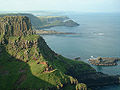
, and the nearby Giant's CausewayGiant's CausewayThe Giant's Causeway is an area of about 40,000 interlocking basalt columns, the result of an ancient volcanic eruption. It is located in County Antrim on the northeast coast of Northern Ireland, about three miles northeast of the town of Bushmills...
. - DerryDerryDerry or Londonderry is the second-biggest city in Northern Ireland and the fourth-biggest city on the island of Ireland. The name Derry is an anglicisation of the Irish name Doire or Doire Cholmcille meaning "oak-wood of Colmcille"...
and its Walled City.