
Cooley peninsula
Encyclopedia
Peninsula
A peninsula is a piece of land that is bordered by water on three sides but connected to mainland. In many Germanic and Celtic languages and also in Baltic, Slavic and Hungarian, peninsulas are called "half-islands"....
in County Louth
County Louth
County Louth is a county of Ireland. It is part of the Border Region and is also located in the province of Leinster. It is named after the town of Louth. Louth County Council is the local authority for the county...
, Ireland
Republic of Ireland
Ireland , described as the Republic of Ireland , is a sovereign state in Europe occupying approximately five-sixths of the island of the same name. Its capital is Dublin. Ireland, which had a population of 4.58 million in 2011, is a constitutional republic governed as a parliamentary democracy,...
, which includes towns such as Omeath
Omeath
Omeath is a village on the R173 regional road in County Louth, Ireland, close to the border with Northern Ireland. It is roughly mid way between Dublin and Belfast, very near the County Louth and County Armagh / County Down border. Omeath has a population of 439, and is approximately from...
, Carlingford
Carlingford, County Louth
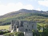
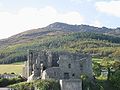
Carlingford is a coastal town and townland in northern County Louth, Ireland. It is situated between Carlingford Lough and Slieve Foy, sometimes known as Carlingford Mountain...
and Greenore
Greenore
Greenore is a small town, townland and deep water port on Carlingford Lough in County Louth, Ireland. The population of Greenore and the surrounding rural area was 898 in the 2002 Irish census....
.
Geography
The peninsula contains the Cooley MountainsCooley Mountains
The Cooley Mountains are located on the Cooley Peninsula in northeast County Louth in Ireland. They consist of two ridges oriented northwest to southeast, separated by the valley of Glenmore with the Big River running through it....
, the highest of which, Slieve Foy
Slieve Foy
Slieve Foy or Slieve Foye is the highest peak of a ridge of mountains collectively referred to as Carlingford Mountain, which rises near the town of Carlingford, County Louth, Ireland. Slieve Foy rises to an altitude of 588 metres, and at this is the highest peak in County Louth...
, is also the highest peak in County Louth at 588m. To the north is Carlingford Lough
Carlingford Lough
Carlingford Lough is a glacial fjord or sea inlet that forms part of the border between Northern Ireland to the north and the Republic of Ireland to the south. On its northern shore is County Down and on its southern shore is County Louth...
and the border with Northern Ireland
Northern Ireland
Northern Ireland is one of the four countries of the United Kingdom. Situated in the north-east of the island of Ireland, it shares a border with the Republic of Ireland to the south and west...
; to the south is Dundalk
Dundalk
Dundalk is the county town of County Louth in Ireland. It is situated where the Castletown River flows into Dundalk Bay. The town is close to the border with Northern Ireland and equi-distant from Dublin and Belfast. The town's name, which was historically written as Dundalgan, has associations...
Bay.
The peninsula is ringed by the R173
R173 road
The R173 road is a regional road in Ireland, running its full length in County Louth. It loops around Cooley Peninsula, mainly along the coast...
regional road
Regional road
A regional road in Ireland is a class of road not forming a major route , but nevertheless forming a link in the national route network. There are over 11,600 kilometres of regional roads. Regional roads are numbered with three digit route numbers, prefixed by "R" A regional road in Ireland is a...
.
Antiquity
In Irish mythologyIrish mythology
The mythology of pre-Christian Ireland did not entirely survive the conversion to Christianity, but much of it was preserved, shorn of its religious meanings, in medieval Irish literature, which represents the most extensive and best preserved of all the branch and the Historical Cycle. There are...
Cooley (Old Irish
Old Irish language
Old Irish is the name given to the oldest form of the Goidelic languages for which extensive written texts are extant. It was used from the 6th to the 10th centuries, by which time it had developed into Middle Irish....
Cúalnge) was the home of the bull Donn Cúailnge
Donn Cuailnge
In the Ulster Cycle of Irish mythology Donn Cúailnge, the Brown Bull of Cooley, was an extremely fertile stud bull over whom the Táin Bó Cúailnge was fought....
, and the site of the Táin Bó Cúailnge
Táin Bó Cúailnge
is a legendary tale from early Irish literature, often considered an epic, although it is written primarily in prose rather than verse. It tells of a war against Ulster by the Connacht queen Medb and her husband Ailill, who intend to steal the stud bull Donn Cuailnge, opposed only by the teenage...
or Cattle Raid of Cooley. Ancient monuments in Cooley include the Proleek Dolmen
Dolmen
A dolmen—also known as a portal tomb, portal grave, dolmain , cromlech , anta , Hünengrab/Hünenbett , Adamra , Ispun , Hunebed , dös , goindol or quoit—is a type of single-chamber megalithic tomb, usually consisting of...
, whose capstone weighs an estimated 46 tons (46.7 tonnes), and a Bronze Age
Bronze Age
The Bronze Age is a period characterized by the use of copper and its alloy bronze as the chief hard materials in the manufacture of some implements and weapons. Chronologically, it stands between the Stone Age and Iron Age...
gallery grave
Gallery grave
A Gallery grave is a form of Megalithic tomb where there is no size difference between the burial chamber itself and the entrance passage. Two parallel walls of stone slabs were erected to form a corridor and covered with a line of capstones. The rectangular tomb was covered with a barrow or a cairn...
, both near Ballymascanlon
Ballymascanlon
Ballymascanlan , otherwise Ballymascanlon, is a small village and townland in County Louth, Ireland, situated 4 km north-east of Dundalk on the road to Carlingford.-History:...
.