Cadamstown
Encyclopedia
Cadamstown, historically called Ballymacadam , is a small village
in County Offaly
, Ireland
. It lies on the R421
regional road
, just north of the Slieve Bloom Mountains
. It is about 20 km from Tullamore
and 6 km from Kinnitty
.
, which is crossed by the R421. The road forms the Main Street of the village. The village has a picnic area, public house, shop/post office and teashop. The plan is predominantly linear, centred on the bridge over the Silver River and comprises a Church, public house and approximately 20 houses, with a population of approximately 60 people. The Mill is to the west and the Ardara Masonry Bridge (which has been taken into National care) is to the north.

 Baile Mhic Ádaim is the Irish name for the town and castle, from which the English name derives. One source mentions that Mac Ádaim was a northern chieftain who settled in the area, while another offers the view that by the 1640s the area was in the possession of Adam Lord Viscount Loftus of Ely and that the “Adam” in the name is the Lord Viscount himself.
There was no mill in Cadamstown until 1831 when Sina Manifold, the wife of Dan Manifold, built the present mill. The old abbey of Leitir Lughna (one mile south of the village) was pulled down and the stones used in the construction of the mill. In 1890 the Manifolds sold the mill to William Slevin, from Belfast
, who converted it into a woollen mill. The mill remains but is disused. Opposite the mill stood the miller’s house which was used, during the Irish Rebellion of 1798
, as a yeoman’s barracks. Later it was used again as the miller’s house by Dan Manifold, then by William Slevin, who lived there with his son Pat. James Gaffney became owner when the Slevins died. Local historian Paddy Heaney currently owns the house.
Village
A village is a clustered human settlement or community, larger than a hamlet with the population ranging from a few hundred to a few thousand , Though often located in rural areas, the term urban village is also applied to certain urban neighbourhoods, such as the West Village in Manhattan, New...
in County Offaly
County Offaly
County Offaly is a county in Ireland. It is part of the Midlands Region and is also located in the province of Leinster. It is named after the ancient Kingdom of Uí Failghe and was formerly known as King's County until the establishment of the Irish Free State in 1922. Offaly County Council is...
, Ireland
Republic of Ireland
Ireland , described as the Republic of Ireland , is a sovereign state in Europe occupying approximately five-sixths of the island of the same name. Its capital is Dublin. Ireland, which had a population of 4.58 million in 2011, is a constitutional republic governed as a parliamentary democracy,...
. It lies on the R421
R421 road
The R421 road is a regional road in Ireland which runs southwest-northeast from the N62 in Roscrea to the N52 just south of Tullamore.The route is long.-See also:*Roads in Ireland*National primary road*National secondary road-References:...
regional road
Regional road
A regional road in Ireland is a class of road not forming a major route , but nevertheless forming a link in the national route network. There are over 11,600 kilometres of regional roads. Regional roads are numbered with three digit route numbers, prefixed by "R" A regional road in Ireland is a...
, just north of the Slieve Bloom Mountains
Slieve Bloom Mountains
Situated close to the geographical centre of Ireland The Slieve Bloom Mountains rise from the central plain of Ireland to a height of 527 metres. While not very high, they are extensive by local standards...
. It is about 20 km from Tullamore
Tullamore
Tullamore is a town in County Offaly, in the midlands of Ireland. It is Offaly's county town and the centre of the district.Tullamore is an important commercial and industrial centre in the region. Major international employers in the town include 'Tyco Healthcare' and 'Boston Scientific'. In...
and 6 km from Kinnitty
Kinnitty
Kinnitty is a village in County Offaly, Ireland. It is located 13 km east of Birr on the R440 and R421 regional roads.The village derives its name from the myth that the head of an ancient princess is buried beneath the village, Ceann being Irish for head and Eitigh being the name of the...
.
Features
The village is divided by the gorge of the Silver RiverSilver River (Ireland)
The Silver River flows from the Slieve Bloom Mountains in the south of County Offaly in central Ireland. The village of Cadamstown, on the river, is home of The Silver River Geological Reserve.-Course:...
, which is crossed by the R421. The road forms the Main Street of the village. The village has a picnic area, public house, shop/post office and teashop. The plan is predominantly linear, centred on the bridge over the Silver River and comprises a Church, public house and approximately 20 houses, with a population of approximately 60 people. The Mill is to the west and the Ardara Masonry Bridge (which has been taken into National care) is to the north.
History


There was no mill in Cadamstown until 1831 when Sina Manifold, the wife of Dan Manifold, built the present mill. The old abbey of Leitir Lughna (one mile south of the village) was pulled down and the stones used in the construction of the mill. In 1890 the Manifolds sold the mill to William Slevin, from Belfast
Belfast
Belfast is the capital of and largest city in Northern Ireland. By population, it is the 14th biggest city in the United Kingdom and second biggest on the island of Ireland . It is the seat of the devolved government and legislative Northern Ireland Assembly...
, who converted it into a woollen mill. The mill remains but is disused. Opposite the mill stood the miller’s house which was used, during the Irish Rebellion of 1798
Irish Rebellion of 1798
The Irish Rebellion of 1798 , also known as the United Irishmen Rebellion , was an uprising in 1798, lasting several months, against British rule in Ireland...
, as a yeoman’s barracks. Later it was used again as the miller’s house by Dan Manifold, then by William Slevin, who lived there with his son Pat. James Gaffney became owner when the Slevins died. Local historian Paddy Heaney currently owns the house.
Places of interest
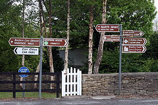
- The village has many scenic walks including the start of the Offaly Way, a 29 km, long-distance walking trail linking the Slieve Bloom and Grand Canal Ways.
- The Church and its grounds contain a cross inscribed grave slab, a 12th century decorated animal head and a human face, possibly Saint Lugna. It is possible that these stones, as well as many more used in constructing Cadamstown, were originally from the Church at Letter.
- Silver River Geological Reserve provides an insight into a landscape and the Silver River gorge.
- Ardara Bridge, a high arch spanning the Silver River, is of great architectural importance, being one of only a handful of such medieval bridges in Ireland. In 2006, the Office of Public Works acquired the bridge as a major conservation project was required to save the bridge from collapse, and to make it safe for public access.
People
- It is the home of local historian Paddy Heaney who has written several books on historical events and folkloreFolkloreFolklore consists of legends, music, oral history, proverbs, jokes, popular beliefs, fairy tales and customs that are the traditions of a culture, subculture, or group. It is also the set of practices through which those expressive genres are shared. The study of folklore is sometimes called...
in the region, including At the Foot of the Slieve Bloom - History and Folklore of Cadamstown. - The village was at one time home to Charles O'Carroll whose grandson was a signatory of the United States Declaration of IndependenceUnited States Declaration of IndependenceThe Declaration of Independence was a statement adopted by the Continental Congress on July 4, 1776, which announced that the thirteen American colonies then at war with Great Britain regarded themselves as independent states, and no longer a part of the British Empire. John Adams put forth a...
in 1776.
See also
- List of towns and villages in Ireland

