

N60 road (Ireland)
Encyclopedia
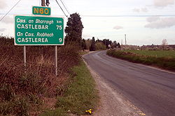
The N60 road is a national secondary road
in Ireland
, linking Castlebar
, County Mayo
to Roscommon
town. The quality of the road varies significantly, with County Roscommon
having a better alignment. The worst section of the route is between Castlebar and Claremorris
where some stretches are dangerously narrow. This section of the route is also the busiest with up to 7,000 vehicles daily. The N60 in County Mayo has seen very little improvement works carried out since the 1970s. The road remains almost the same except for the Claremorris relief road which was constructed in two stages between 1988 and 2000. This relief road removes the majority of the 7,000 vehicles daily from Claremorris town centre, in particular Mount St which was once notorious for tailbacks, as traffic had to give way to the busy N17 which once passed through the town.
A new route between Castlebar and Claremorris has been in planning for many years and will bypass the village of Balla
when constructed.
 (Northwest to Southeast)
It starts at the N5 Castlebar ring-road and runs southeast to Claremorris
. At Claremorris it turns east crossing over the N17 at a grade separated junction. It continues east to Ballyhaunis
where it crosses the N83
. Continuing eastwards it enters County Roscommon
and passes through Ballinlough
to Castlerea
where it turns south to Ballymoe
(in County Galway
)and finally southeast to Roscommon town where it terminates at a ring-road which joins it to the N61
and N63
national secondary roads.
The route originally continued from Castlebar to Westport
, however this section became part of the N5 in 1994.
National secondary road
A national secondary road is a category of road in Ireland. These roads form an important part of the national route network, but are secondary to the main arterial routes which are classified as national primary roads. National secondary roads are designated with route numbers higher than those...
in Ireland
Republic of Ireland
Ireland , described as the Republic of Ireland , is a sovereign state in Europe occupying approximately five-sixths of the island of the same name. Its capital is Dublin. Ireland, which had a population of 4.58 million in 2011, is a constitutional republic governed as a parliamentary democracy,...
, linking Castlebar
Castlebar
Castlebar is the county town of, and at the centre of, County Mayo in Ireland. It is Mayo's largest town by population. The town's population exploded in the late 1990s, increasing by one-third in just six years, though this massive growth has slowed down greatly in recent years...
, County Mayo
County Mayo
County Mayo is a county in Ireland. It is located in the West Region and is also part of the province of Connacht. It is named after the village of Mayo, which is now generally known as Mayo Abbey. Mayo County Council is the local authority for the county. The population of the county is 130,552...
to Roscommon
Roscommon
Roscommon is the county town of County Roscommon in Ireland. Its population at the 2006 census stood at 5,017 . The town is located near the junctions of the N60, N61 and N63 roads.-History:...
town. The quality of the road varies significantly, with County Roscommon
County Roscommon
County Roscommon is a county in Ireland. It is located in the West Region and is also part of the province of Connacht. It is named after the town of Roscommon. Roscommon County Council is the local authority for the county...
having a better alignment. The worst section of the route is between Castlebar and Claremorris
Claremorris
Claremorris , is a town in County Mayo in the west of Ireland, at the junction of the N17 and the N60 national routes. The population of Claremoris in the 2011 Census was 3,979....
where some stretches are dangerously narrow. This section of the route is also the busiest with up to 7,000 vehicles daily. The N60 in County Mayo has seen very little improvement works carried out since the 1970s. The road remains almost the same except for the Claremorris relief road which was constructed in two stages between 1988 and 2000. This relief road removes the majority of the 7,000 vehicles daily from Claremorris town centre, in particular Mount St which was once notorious for tailbacks, as traffic had to give way to the busy N17 which once passed through the town.
A new route between Castlebar and Claremorris has been in planning for many years and will bypass the village of Balla
Balla
Balla is a village in County Mayo, Ireland on the N60 National secondary road, the main road between Castlebar and Claremorris. The economy of the village survives mainly on passing trade, from the busy N60 which carries over 7,000 vehicles through the village every day. The village is to be...
when constructed.
Route
It starts at the N5 Castlebar ring-road and runs southeast to Claremorris
Claremorris
Claremorris , is a town in County Mayo in the west of Ireland, at the junction of the N17 and the N60 national routes. The population of Claremoris in the 2011 Census was 3,979....
. At Claremorris it turns east crossing over the N17 at a grade separated junction. It continues east to Ballyhaunis
Ballyhaunis
Ballyhaunis is a town in County Mayo, Ireland. It is situated at the crossroads of the N60 and N83 National secondary roads and on the railway line connecting Dublin to Westport and Ballina....
where it crosses the N83
N83 road (Ireland)
The N83 road is a national secondary road in Ireland that runs from its junction with the N17 just south of Ireland West Airport Knock in County Mayo to a point just north of Tuam, County Galway where it rejoins the N17.Total length is ....
. Continuing eastwards it enters County Roscommon
County Roscommon
County Roscommon is a county in Ireland. It is located in the West Region and is also part of the province of Connacht. It is named after the town of Roscommon. Roscommon County Council is the local authority for the county...
and passes through Ballinlough
Ballinlough, County Roscommon
Ballinlough is a small town in County Roscommon, Ireland. The N60 national secondary road passes through it. The town is between Ballyhaunis and Castlerea on the Roscommon to Castlebar road....
to Castlerea
Castlerea
Castlerea is located in the west of County Roscommon, Ireland. It is the second largest town in the county with a population of 3,055 . Roughly translated from Irish, Castlerea can mean Brindled Castle or King's Castle...
where it turns south to Ballymoe
Ballymoe
Ballymoe is a village in County Galway, Ireland. Ballymoe is situated on the western side of the River Suck that separates counties Galway and Roscommon...
(in County Galway
County Galway
County Galway is a county in Ireland. It is located in the West Region and is also part of the province of Connacht. It is named after the city of Galway. Galway County Council is the local authority for the county. There are several strongly Irish-speaking areas in the west of the county...
)and finally southeast to Roscommon town where it terminates at a ring-road which joins it to the N61
N61 road (Ireland)
The N61 road is a national secondary road in County Roscommon, Ireland, linking the N4, N5 and N6 national primary roads.-Route:Starting at Athlone , the road goes Northwards to Knockcroghery, Roscommon, Tulsk , and ends just North of Boyle at the N4....
and N63
N63 road (Ireland)
The N63 road is a national secondary road in Ireland. It links the N17 northeast of Galway, to the N5 national primary road in Longford.En route it passes through Mountbellew, Roscommon Town, crosses the River Shannon at Lanesborough.The road is long....
national secondary roads.
The route originally continued from Castlebar to Westport
Westport, County Mayo
Westport is a town in County Mayo, Ireland. It is situated on the west coast at the south-east corner of Clew Bay, an inlet of the Atlantic Ocean....
, however this section became part of the N5 in 1994.
See also
- Roads in IrelandRoads in IrelandThe island of Ireland, comprising Northern Ireland and the Republic of Ireland, has an extensive network of tens of thousands of kilometres of public roads, usually surfaced. These roads have been developed and modernised over centuries, from trackways suitable only for walkers and horses, to...
- Motorways in Ireland
- National primary roadNational primary roadA national primary road is a road classification in the Republic of Ireland. National primary roads form the major routes between the major urban centres. There are over 2,700km of national primary roads. This category of road has the prefix "N" followed by one or two digits...
- Regional roadRegional roadA regional road in Ireland is a class of road not forming a major route , but nevertheless forming a link in the national route network. There are over 11,600 kilometres of regional roads. Regional roads are numbered with three digit route numbers, prefixed by "R" A regional road in Ireland is a...