

R173 road
Encyclopedia
Regional road
A regional road in Ireland is a class of road not forming a major route , but nevertheless forming a link in the national route network. There are over 11,600 kilometres of regional roads. Regional roads are numbered with three digit route numbers, prefixed by "R" A regional road in Ireland is a...
in Ireland
Republic of Ireland
Ireland , described as the Republic of Ireland , is a sovereign state in Europe occupying approximately five-sixths of the island of the same name. Its capital is Dublin. Ireland, which had a population of 4.58 million in 2011, is a constitutional republic governed as a parliamentary democracy,...
, running its full length in County Louth
County Louth
County Louth is a county of Ireland. It is part of the Border Region and is also located in the province of Leinster. It is named after the town of Louth. Louth County Council is the local authority for the county...
. It loops around Cooley Peninsula
Cooley peninsula
The Cooley Peninsula is a hilly peninsula in County Louth, Ireland, which includes towns such as Omeath, Carlingford and Greenore.-Geography:...
, mainly along the coast. It nearly encircles the Cooley Mountains
Cooley Mountains
The Cooley Mountains are located on the Cooley Peninsula in northeast County Louth in Ireland. They consist of two ridges oriented northwest to southeast, separated by the valley of Glenmore with the Big River running through it....
.
It starts at a roundabout at Ballymascanlan, just north of Dundalk
Dundalk
Dundalk is the county town of County Louth in Ireland. It is situated where the Castletown River flows into Dundalk Bay. The town is close to the border with Northern Ireland and equi-distant from Dublin and Belfast. The town's name, which was historically written as Dundalgan, has associations...
, where it meets the N52 and the M1/N1 roads.
It then heads east, along the northern coast of Dundalk Bay to The Bush where it veers north, past the village of Grange to Carlingford
Carlingford, County Louth
Carlingford is a coastal town and townland in northern County Louth, Ireland. It is situated between Carlingford Lough and Slieve Foy, sometimes known as Carlingford Mountain...
.
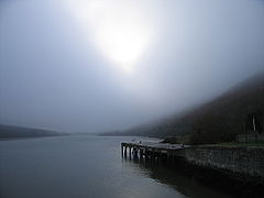
From there it heads NW along the southern shore of Carlingford Lough
Carlingford Lough
Carlingford Lough is a glacial fjord or sea inlet that forms part of the border between Northern Ireland to the north and the Republic of Ireland to the south. On its northern shore is County Down and on its southern shore is County Louth...
, through the village of Omeath
Omeath
Omeath is a village on the R173 regional road in County Louth, Ireland, close to the border with Northern Ireland. It is roughly mid way between Dublin and Belfast, very near the County Louth and County Armagh / County Down border. Omeath has a population of 439, and is approximately from...
to the Northern Ireland
Northern Ireland
Northern Ireland is one of the four countries of the United Kingdom. Situated in the north-east of the island of Ireland, it shares a border with the Republic of Ireland to the south and west...
border where it becomes the B79 into Newry
Newry
Newry is a city in Northern Ireland. The River Clanrye, which runs through the city, formed the historic border between County Armagh and County Down. It is from Belfast and from Dublin. Newry had a population of 27,433 at the 2001 Census, while Newry and Mourne Council Area had a population...
, County Down
County Down
-Cities:*Belfast *Newry -Large towns:*Dundonald*Newtownards*Bangor-Medium towns:...
.
The R173 is a former Trunk Road
Trunk Roads in Ireland
Ireland has an extensive network of public roads which connect all parts of the country with each other. Roads in Ireland are currently classified as motorways, National Primary routes, National secondary routes, Regional roads and Local roads. The introduction of this classification system began...
and was previously numbered as the T62.
The road is 32 km (19.9 mi) long.