

Ring of Kerry
Encyclopedia
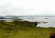
The Ring of Kerry is a tourist trail in County Kerry
County Kerry
Kerry means the "people of Ciar" which was the name of the pre-Gaelic tribe who lived in part of the present county. The legendary founder of the tribe was Ciar, son of Fergus mac Róich. In Old Irish "Ciar" meant black or dark brown, and the word continues in use in modern Irish as an adjective...
, south-western Ireland
Ireland
Ireland is an island to the northwest of continental Europe. It is the third-largest island in Europe and the twentieth-largest island on Earth...
. The route covers the 179 km circular road (N70
N70 road (Ireland)
The N70 road is a national secondary road in Ireland. It comprises most of the Ring of Kerry.-Route: – Sneem – Castlecove – Caherdaniel – Waterville – Cahersiveen – Killorglin – – Milltown – Castlemaine – – Tralee.-See also:*Roads...
, N71
N71 road (Ireland)
-Road standard:The road is mostly relatively poor single carriageway, with better sections towards the Cork end of the route. There are wide sections with climbing/passing lanes, including a very rare configuration with a passing lane on both sides, and a dual carriageway section approaching...
and R562), starting from Killarney
Killarney
Killarney is a town in County Kerry, southwestern Ireland. The town is located north of the MacGillicuddy Reeks, on the northeastern shore of the Lough Lein/Leane which are part of Killarney National Park. The town and its surrounding region are home to St...
, heading around the Iveragh Peninsula
Iveragh Peninsula
The Iveragh Peninsula is located in County Kerry in Ireland. It is the largest peninsula in southwestern Ireland. A mountain range, the Macgillycuddy's Reeks, lies in the centre of the peninsula...
and passing through Kenmare
Kenmare
Kenmare is a small town in the south of County Kerry, Ireland. The name Kenmare is the anglicised form of Ceann Mara meaning "head of the sea", referring to the head of Kenmare Bay.-Location:...
, Sneem
Sneem
Sneem is a town situated on the Iveragh Peninsula in County Kerry in the southwest of Ireland. It lies on the estuary of the River Sneem. National route N70 runs through the town....
, Waterville
Waterville, County Kerry
Waterville, historically known as Carrean , is a village in County Kerry, Ireland, on the Iveragh peninsula. The town is sited on a narrow isthmus, with Lough Currane on the east side of the town, and Ballinskelligs Bay on the west, and the Currane River connecting the two.The town's name in Irish...
, Cahersiveen and Killorglin
Killorglin
Killorglin is a town in County Kerry, Ireland. It is located on the river Laune, which has a rowing club and a new boathouse. The population of Killorglin is 4,150 although this expands considerably during Puck Fair due to visitors and returning emigrants.Killorglin is a major activity centre...
. Popular points include Muckross House
Muckross House
Muckross House is located on the small Muckross Peninsula between Muckross Lake and Lough Leane, two of the lakes of Killarney, from the town of Killarney in County Kerry, Ireland....
(near Killarney), Staigue stone fort and Derrynane House
Derrynane House
Derrynane House was the home of Irish politician and statesman, Daniel O'Connell. It is now an Irish National Monumement and part of a 320 acre National Park....
, home of Daniel O'Connell
Daniel O'Connell
Daniel O'Connell Daniel O'Connell Daniel O'Connell (6 August 1775 – 15 May 1847; often referred to as The Liberator, or The Emancipator, was an Irish political leader in the first half of the 19th century...
. Just south of Killarney, Ross Castle
Ross Castle
Ross Castle is the ancestral home of the O'Donoghue clan though it is better known for its association with the Brownes of Killarney who owned it until recently...
, Lough Leane
Lakes of Killarney
The Lakes of Killarney are a renowned scenic attraction located near Killarney, County Kerry, in Ireland. They consist of three lakes - Lough Leane, Muckross Lake and Upper Lake.Lough Leane is the largest of the three lakes...
, and Ladies View
Ladies View (Ireland)
Ladies View is a scenic point along the N71 portion of the Ring of Kerry, in Killarney National Park, Ireland. The name apparently stems from the admiration of the view given by Queen Victoria's ladies-in-waiting during their 1861 visit....
(a panoramic viewpoint), all located within Killarney National Park
Killarney National Park
Killarney National Park is located beside the town of Killarney, County Kerry, Ireland. It was the first national park established in Ireland, created when Muckross Estate was donated to the Irish state in 1932...
, are major attractions located along the Ring. A more complete list of major attractions along the Ring of Kerry includes: Gap of Dunloe
Gap of Dunloe
The Gap of Dunloe is a narrow mountain pass between Macgillycuddy's Reeks and Purple Mountain in County Kerry, Ireland. It is about from north to south. Within it are five lakes: Coosaun Lough, Black Lake, Cushnavally Lake, Auger Lake, and Black Lough . These lakes are connected by the River Loe...
, Bog Village, Rossbeigh Beach, Cahersiveen Heritage Centre, Derrynane House
Derrynane House
Derrynane House was the home of Irish politician and statesman, Daniel O'Connell. It is now an Irish National Monumement and part of a 320 acre National Park....
, Skellig Experience, Staigue Fort, Kenmare Lace, Moll's Gap
Moll's Gap
Moll's Gap is a pass on the N71 road from Kenmare to Killarney in County Kerry Ireland. On the Ring of Kerry route, with views of the Macgillycuddy's Reeks mountains, the area and its shop is a panoramic spot visited by thousands of tourists each year...
, Ladies View
Ladies View (Ireland)
Ladies View is a scenic point along the N71 portion of the Ring of Kerry, in Killarney National Park, Ireland. The name apparently stems from the admiration of the view given by Queen Victoria's ladies-in-waiting during their 1861 visit....
, Torc Waterfall
Torc Waterfall
Torc Waterfall is a waterfall at the base of Torc Mountain, about from Killarney in County Kerry, Ireland.The falls are one of the landmarks on the 200 kilometre Kerry Way walking tour, and are encompassed in the Killarney National Park...
, Muckross House, The Blue Pool, Ross Castle, Ogham
Ogham
Ogham is an Early Medieval alphabet used primarily to write the Old Irish language, and occasionally the Brythonic language. Ogham is sometimes called the "Celtic Tree Alphabet", based on a High Medieval Bríatharogam tradition ascribing names of trees to the individual letters.There are roughly...
Stones, St Mary’s Cathedral, Muckross Abbey
Muckross Abbey
Muckross Abbey is one of the major ecclesiastical sites found in the Killarney National Park, County Kerry, Republic of Ireland. It was founded in 1448 as a Franciscan friary for the Observantine Franciscans by Donal McCarthy Mor....
, Franciscan Friary, Kellegy Church, O’Connell Memorial Church, Sneem Church and Cemetery, Skellig Michael
Skellig Michael
Skellig Michael , also known as Great Skellig, is a steep rocky island in the Atlantic Ocean about 9 miles from the coast of County Kerry, Ireland. It is the larger of the two Skellig Islands...
, Beehive Cells and the Stone Pillars marking an important grave.
There is also an established walking path named The Kerry Way
Kerry Way
The Kerry Way is a long-distance trail in County Kerry, Ireland. It is a long circular trail that begins and ends in Killarney. It is typically completed in nine days. It is designated as a National Waymarked Trail by the National Trails Office of the Irish Sports Council and is managed by Kerry...
, which takes its own route, and a signposted Ring of Kerry cycling path which uses older quieter roads where possible. The Kerry Way roughly follows the scenic driving route of the Ring of Kerry.
There are numerous variations to the route taking in St. Finian's Bay and Valentia Island
Valentia Island
Valentia Island is one of Ireland's westernmost points, lying off the Iveragh Peninsula in the southwest of County Kerry, Ireland. It is linked to the mainland by the Maurice O'Neill Memorial bridge at Portmagee, as well as by a ferry which sails from Reenard Point to Knightstown, the island's...
which the official driving ring misses (the official cycling route takes in Valentia island). The Ring of Kerry has much to offer in terms of attractions. Not only does it have some of Europe's finest beaches, but also offers the Gap of Dunloe, Bog Village, Derrynane House, the Skellig Experience Valentia Island, Molls Gap, Torc Waterfall, Muckross House and Ross Castle.
"The Ring" is a popular day trip and numerous bus companies offer trips during the summer months. As the narrow roads make it difficult for tour coaches to pass, all tour buses run in an anti-clockwise (or counter-clockwise) direction, traveling via Killorglin first. It is recommended that car owners travel in the opposite direction, going first to Kenmare to avoid delays caused by tour buses. In 2008 satellite navigation systems
Automotive navigation system
An automotive navigation system is a satellite navigation system designed for use in automobiles. It typically uses a GPS navigation device to acquire position data to locate the user on a road in the unit's map database. Using the road database, the unit can give directions to other locations...
were blamed for directing bus drivers in a clockwise direction around the route.