
.gif)
San Pedro River (Arizona)
Encyclopedia
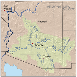
San Pedro River is a northward-flowing stream
originating about ten miles (16 km) south of Sierra Vista, Arizona
near Cananea
, Sonora
, Mexico
. It is one of only two rivers which flow north from Mexico into the United States. The river flows 140 miles (225.3 km) north through Cochise County
, Pima County
, Graham County
, and Pinal County
to its confluence with the Gila River
, at Winkelman, Arizona
. It is the last major, free-flowing undammed river in the American Southwest
, it is of major ecological importance as it hosts two-thirds of the avian diversity in the United States, including 100 species of breeding birds and 300 species of migrating birds.
, the Murray Springs Clovis Site and the Naco Mammoth-Kill Site.
The hunter-gatherer, Cochise Culture next made this area home between about 5000 to 200 BC. Followed by the more advanced Mogollon, Hohokam and Salado
cultures who built permanent homes and engaged in agriculture here. By the time the first Europeans arrived these cultures had disappeared and the San Pedro River was home to the Sobaipuri
people.
The first Europeans to visit the San Pedro River may have been the parties of Cabeza de Vaca, Fray Marcos de Niza or the Coronado expedition, although no archeological evidence exists of the passing of these groups. The Jesuit priest Eusebio Kino
visited the villages along the San Pedro and Babacomari Rivers in 1692 and soon after introduced the first livestock to this area.
It is widely believed that by 1762 Apache
depredation drove the Sobaipuri and Spanish out of the San Pedro Valley which then remained largely uninhabited until the early 1800s. This, however, is not true as a recent study has shown. In fact, documents state that not all the Sobaipuri left and in the 1780s Sobaipuri were noted still living along the river. Archaeology has confirmed additional Sobaipuri settlements along the middle San Pedro not mentioned in the documentary record throughout the 1800s.
Early American exploration of the San Pedro River, like most rivers in western North America, was driven by the pursuit of beaver pelts. James Ohio Pattie and his father led a party of fur trappers down the Gila River and then down the San Pedro River in 1826 which was so successful that he called the San Pedro the Beaver River. In the 19th century the river was a meandering stream with fluvial marshlands, riparian forest, Sporobolus
grasslands and extensive beaver ponds. As the beaver were removed by fur trapping and cattle denuded the riparian vegetation, the river down-cut and then widened in a process of arroyo formation observed on many rivers in the Southwest. The beaver were finally extirpated by 1920's dynamiting of the beaver dams from soldiers from Fort Huachuca
to prevent malaria. By the mid-20th century the once perennial river only flowed during the rainy season and beaver, fluvial marshlands and Sporobolus grasslands were uncommon. Physician naturalist Edgar Alexander Mearns
' 1907 Mammals of the Mexican boundary of the United States reported beaver (Castor canadensis) on the San Pedro River and Babocomari Creek. Mearns claimed that the San Pedro River beaver represented a new subspecies Castor canadensis frondator or "Sonora beaver" that ranged from Mexico up to Wyoming and Montana.
 The San Pedro River is the central corridor of the Madrean Archipelago
of "Sky Islands
", high mountains with unique ecosystems different from the ecology of the Sonoran desert "seas" that surround it.
More than 300 species of birds, 200 species of butterflies and 20 species of bat
s use this corridor as they migrate between South
, Central
and North America
, including the imperiled Yellow-billed Cuckoo
(Coccyzus americanus). More than 80 species of mammals, including jaguar
(Panthera onca), coatimundi (Nasua narica), bats, beaver (Castor canadensis frontador), mountain lion, and many rodents; more than 65 species of reptiles and amphibians, including Sonoran tiger salamander (Ambystoma mavortium
stebbinsi) and Western Barking Frog (Eleutherodactylus augusti
). Remaining native fish species include the Gila chub
(Gila intermedia) which is proposed for federal listing as endangered, and the longfin dace, desert sucker, roundtail chub, Sonora sucker, and speckled dace. The flora includes Fremont cottonwood (Populus fremontii), Goodding willow (Salix gracilistyla), velvet mesquite, sacaton, and the Federally endangered Huachaca water umbel (Lilaeopsis schaffneriana spp. recurva).
In recent decades, rapid growth and population increases in southern Arizona has caused concern with this river. Several non-profit organizations have risen in recent years to raise awareness of this problem. The San Pedro Riparian National Conservation Area
(SPRNCA) was established in 1988 to protect some forty miles of the upper San Pedro valley. The Nature Conservancy also owns several preserves in the watershed, including the San Pedro River Preserve
, Aravaipa Canyon Preserve, Muleshoe Ranch Preserve, Ramsey Canyon Preserve, and most recently, Rancho Los Fresnos. Rancho Los Fresnos, near the river's source, is the largest ciénega
, an isolated desert spring or marsh, remaining in the San Pedro River watershed. Its protection is important as 99% of the ciénegas in the Southwest have been drained and destroyed.
 With large portions of the river dry much of the year, Bureau of Land Management
(BLM) wildlife biologist Mark Fredlake proposed restoring beaver to the watershed to retain water flows into the dry season and to support re-growth of the historic riparian vegetation. Riparian habitat covers only 1% of the Southwest but supports 50% of breeding bird species and is vital as a food source for migrating avifauna. Fredlake reasoned that beaver dam
s would raise the water table, allowing groundwater to recharge the river's flow in the dry season. From 1999 to 2002, 19 beavers were released into the SPRNCA, a 40 miles (64.4 km) stretch of the river, in Cochise County. By 2006 there were more than 30 dams. The beavers also dispersed widely and rapidly. One beaver migrated to Aravaipa Canyon, more than 100 rivermiles away; another to the river's terminus at the Gila River, earning itself the moniker “the surfing beaver”; and others up into Mexico, building several dams along the river’s upper tributaries. The program was successful with measurable increases in bird diversity and formation of deep pools and lasting flows. In 2008, flooding destroyed all the beaver dams and this was followed by a long drought. However, as in historic times the beaver seems well adapted to the San Pedro River, and the 2009 dam count is back above 30 with a current population between 30 and 120 beavers. A short video reviews the use of re-introduced beaver to restore the river.
, Mule
, Whetstone
, Dragoon
, Rincon
, Little Rincon
, Winchester, Galiuro
, Tortilla, and Santa Catalina Mountains
. The San Pedro is fed by numerous tributaries, which in general, drain relatively short and steep catchments oriented more or less perpendicular to the mainstem. For most of its length the San Pedro flows over sedimentary basin fill deposits, although it is bound by bedrock at the Tombstone Hills at Charleston and near Fairbank, “the Narrows” south of Cascabel, near Redington, and again at Dudleyville (Heindl, 1952). Two major tributaries, Babocomari River and Aravaipa Creek, each have extensive bedrock-lined stretches. Historically the San Pedro has been divided into upper and lower reaches at the Narrows.
On May 27, 2011, a U.S. District judge ruled that Fort Huachaca's plan to pump 6100 acre.ft of groundwater without mitigation plans to replenish the San Pedro River flows failed to protect the endangered Southwestern willow flycatcher (Empidonax traillii) and the Huachuca water umbel will recover from their imperiled status. The ruling was in response to a second lawsuit brought by the Center for Biological Diversity
and the Maricopa Audubon Society. In 2002, in response to an earlier suit filed by the center, another judge tossed out an earlier Wildlife Service biological opinion that the water pumping could be mitigated.
marched through the river valley in 1846, and the only battle the battalion fought in their journey to California occurred near the river. The battalion's presence had aroused curiosity among a number of wild cattle, and the bulls of these herds damaged wagons and injured mules. In response, the men shot dozens of the charging bulls. Mormon
settlers later returned to this area in 1877 to found a settlement that became St. David
, and logged the Huachuca Mountains
to provide lumber for building Fort Huachuca
and Tombstone
.
The San Pedro Valley
is a site for Holocene
mammal fossil
s because of the riparian environment.
In recent decades, the Arizona Geological Society
has focused on the region, as well as researchers. Development pressures, recreation, and groundwater harvesting have led to recent concerns of protecting the region. A recent floodplain
study focused on the Holocene floodplain alluvium
and its history, over a 125 miles (201.2 km) stretch of the river to understand subground waterflow resources.
Geology, groundwater, paleontology
Stream
A stream is a body of water with a current, confined within a bed and stream banks. Depending on its locale or certain characteristics, a stream may be referred to as a branch, brook, beck, burn, creek, "crick", gill , kill, lick, rill, river, syke, bayou, rivulet, streamage, wash, run or...
originating about ten miles (16 km) south of Sierra Vista, Arizona
Sierra Vista, Arizona
Sierra Vista is a city in Cochise County, Arizona, United States. According to 2007 Census Bureau estimates, the population of the city is 43,044....
near Cananea
Cananea
-Economy:Mining is the main source of revenue for Cananea and will be for the foreseeable future. Eighty percent of the population is directly or indirectly supported by mining companies in Cananea. The first and most important mining company is Mexicana de Cananea, S.A. de C.V. owned by and...
, Sonora
Sonora
Sonora officially Estado Libre y Soberano de Sonora is one of the 31 states which, with the Federal District, comprise the 32 Federal Entities of Mexico. It is divided into 72 municipalities; the capital city is Hermosillo....
, Mexico
Mexico
The United Mexican States , commonly known as Mexico , is a federal constitutional republic in North America. It is bordered on the north by the United States; on the south and west by the Pacific Ocean; on the southeast by Guatemala, Belize, and the Caribbean Sea; and on the east by the Gulf of...
. It is one of only two rivers which flow north from Mexico into the United States. The river flows 140 miles (225.3 km) north through Cochise County
Cochise County, Arizona
-2010:Whereas according to the 2010 U.S. Census Bureau:*78.5% White*4.2% Black*1.2% Native American*1.9% Asian*0.3% Native Hawaiian or Pacific Islander*4.0% Two or more races*9.6% Other races*32.4% Hispanic or Latino -2000:...
, Pima County
Pima County, Arizona
-2010:Whereas according to the 2010 U.S. Census Bureau:*74.3% White*3.5% Black*3.3% Native American*2.6% Asian*0.2% Native Hawaiian or Pacific Islander*3.7% Two or more races*12.4% Other races*34.6% Hispanic or Latino -2000:...
, Graham County
Graham County, Arizona
-2010:Whereas according to the 2010 U.S. Census Bureau:*72.1% White*1.8% Black*14.4% Native American*0.5% Asian*0.1% Native Hawaiian or Pacific Islander*2.8% Two or more races*8.3% Other races*30.4% Hispanic or Latino -2000:...
, and Pinal County
Pinal County, Arizona
-2010:Whereas according to the 2010 U.S. Census Bureau:*72.4% White*4.6% Black*5.6% Native American*1.7% Asian*0.4% Native Hawaiian or Pacific Islander*3.8% Two or more races*11.5% Other races*28.5% Hispanic or Latino -2000:...
to its confluence with the Gila River
Gila River
The Gila River is a tributary of the Colorado River, 650 miles long, in the southwestern states of New Mexico and Arizona.-Description:...
, at Winkelman, Arizona
Winkelman, Arizona
Winkelman is a town in Gila and Pinal counties in the U.S. state of Arizona. According to 2006 Census Bureau estimates, the population of the town was 444, almost all of whom lived in Gila County.-Geography:...
. It is the last major, free-flowing undammed river in the American Southwest
Southwestern United States
The Southwestern United States is a region defined in different ways by different sources. Broad definitions include nearly a quarter of the United States, including Arizona, California, Colorado, Nevada, New Mexico, Oklahoma, Texas and Utah...
, it is of major ecological importance as it hosts two-thirds of the avian diversity in the United States, including 100 species of breeding birds and 300 species of migrating birds.
History
The first people to enter the San Pedro Valley were the Clovis people who hunted Mammoth here from 10,000 years ago. The San Pedro Valley has the highest concentration of Clovis sites in North America. Some Clovis sites of note are the Lehner Mammoth-Kill SiteLehner Mammoth-Kill Site
The Lehner Mammoth-Kill Site is a site in southern Arizona that is significant for its association with evidence that mammoths were killed here by Paleo-Indians 9000 years BCE....
, the Murray Springs Clovis Site and the Naco Mammoth-Kill Site.
The hunter-gatherer, Cochise Culture next made this area home between about 5000 to 200 BC. Followed by the more advanced Mogollon, Hohokam and Salado
Salado culture
Salado culture, or Salado Horizon, was a human culture of the Tonto Basin in southeastern Arizona from approximately 1150 CE through the 15th century....
cultures who built permanent homes and engaged in agriculture here. By the time the first Europeans arrived these cultures had disappeared and the San Pedro River was home to the Sobaipuri
Sobaipuri
The Sobaipuri are one of many indigenous groups occupying Sonora at the time Europeans first entered the American Southwest. They were a Piman group who occupied southern Arizona and northern Sonora in the 15th-19th centuries...
people.
The first Europeans to visit the San Pedro River may have been the parties of Cabeza de Vaca, Fray Marcos de Niza or the Coronado expedition, although no archeological evidence exists of the passing of these groups. The Jesuit priest Eusebio Kino
Eusebio Kino
Eusebio Francisco Kino S.J. was an Italian Roman Catholic priest who became famous in what is now northwestern Mexico and the southwestern United States in the region then known as the Pimaria Alta...
visited the villages along the San Pedro and Babacomari Rivers in 1692 and soon after introduced the first livestock to this area.
It is widely believed that by 1762 Apache
Apache
Apache is the collective term for several culturally related groups of Native Americans in the United States originally from the Southwest United States. These indigenous peoples of North America speak a Southern Athabaskan language, which is related linguistically to the languages of Athabaskan...
depredation drove the Sobaipuri and Spanish out of the San Pedro Valley which then remained largely uninhabited until the early 1800s. This, however, is not true as a recent study has shown. In fact, documents state that not all the Sobaipuri left and in the 1780s Sobaipuri were noted still living along the river. Archaeology has confirmed additional Sobaipuri settlements along the middle San Pedro not mentioned in the documentary record throughout the 1800s.
Early American exploration of the San Pedro River, like most rivers in western North America, was driven by the pursuit of beaver pelts. James Ohio Pattie and his father led a party of fur trappers down the Gila River and then down the San Pedro River in 1826 which was so successful that he called the San Pedro the Beaver River. In the 19th century the river was a meandering stream with fluvial marshlands, riparian forest, Sporobolus
Sporobolus
Sporobolus is a genus of grasses in the family Poaceae. They are usually called dropseed grasses or sacaton grasses. They are typical prairie and savanna plants, and they occur in other types of open habitat in warmer climates....
grasslands and extensive beaver ponds. As the beaver were removed by fur trapping and cattle denuded the riparian vegetation, the river down-cut and then widened in a process of arroyo formation observed on many rivers in the Southwest. The beaver were finally extirpated by 1920's dynamiting of the beaver dams from soldiers from Fort Huachuca
Fort Huachuca
Fort Huachuca is a United States Army installation under the command of the United States Army Installation Management Command. It is located in Cochise County, in southeast Arizona, about north of the border with Mexico. Beginning in 1913, for 20 years the fort was the base for the "Buffalo...
to prevent malaria. By the mid-20th century the once perennial river only flowed during the rainy season and beaver, fluvial marshlands and Sporobolus grasslands were uncommon. Physician naturalist Edgar Alexander Mearns
Edgar Alexander Mearns
Edgar Alexander Mearns was a notable American ornithologist and field naturalist....
' 1907 Mammals of the Mexican boundary of the United States reported beaver (Castor canadensis) on the San Pedro River and Babocomari Creek. Mearns claimed that the San Pedro River beaver represented a new subspecies Castor canadensis frondator or "Sonora beaver" that ranged from Mexico up to Wyoming and Montana.
Ecology
Madrean sky islands
The Madrean Sky Islands are enclaves of Madrean pine-oak woodlands, found at higher elevations in a complex of small mountain ranges in southern and southeastern Arizona, southwestern New Mexico, and northwestern Mexico. The sky islands are surrounded at lower elevations by the Sonoran and...
of "Sky Islands
Sky Islands
Sky Islands is a 1993 Jazz album by Ramsey Lewis released on GRP Records.The album peaked at #4 on the Billboard Top Contemporary Jazz Albums chart.-Track listing:-Personnel: *Tony Carpenter - Percussion, Background Vocals...
", high mountains with unique ecosystems different from the ecology of the Sonoran desert "seas" that surround it.
More than 300 species of birds, 200 species of butterflies and 20 species of bat
Bat
Bats are mammals of the order Chiroptera "hand" and pteron "wing") whose forelimbs form webbed wings, making them the only mammals naturally capable of true and sustained flight. By contrast, other mammals said to fly, such as flying squirrels, gliding possums, and colugos, glide rather than fly,...
s use this corridor as they migrate between South
South America
South America is a continent situated in the Western Hemisphere, mostly in the Southern Hemisphere, with a relatively small portion in the Northern Hemisphere. The continent is also considered a subcontinent of the Americas. It is bordered on the west by the Pacific Ocean and on the north and east...
, Central
Central America
Central America is the central geographic region of the Americas. It is the southernmost, isthmian portion of the North American continent, which connects with South America on the southeast. When considered part of the unified continental model, it is considered a subcontinent...
and North America
North America
North America is a continent wholly within the Northern Hemisphere and almost wholly within the Western Hemisphere. It is also considered a northern subcontinent of the Americas...
, including the imperiled Yellow-billed Cuckoo
Yellow-billed Cuckoo
The Yellow-billed Cuckoo, Coccyzus americanus, is a cuckoo. Common folk-names for this bird in the southern United States are Rain Crow and Storm Crow...
(Coccyzus americanus). More than 80 species of mammals, including jaguar
Jaguar
The jaguar is a big cat, a feline in the Panthera genus, and is the only Panthera species found in the Americas. The jaguar is the third-largest feline after the tiger and the lion, and the largest in the Western Hemisphere. The jaguar's present range extends from Southern United States and Mexico...
(Panthera onca), coatimundi (Nasua narica), bats, beaver (Castor canadensis frontador), mountain lion, and many rodents; more than 65 species of reptiles and amphibians, including Sonoran tiger salamander (Ambystoma mavortium
Ambystoma mavortium
Ambystoma mavortium, commonly known as the Barred Tiger Salamander, is a species of salamander found from southwestern Canada in British Columbia, Alberta, Saskatchewan and Manitoba, south through the western United States to Texas and northern Mexico.- Description :The tiger salamander is the...
stebbinsi) and Western Barking Frog (Eleutherodactylus augusti
Eleutherodactylus augusti
The Eastern Barking Frog is a small Leptodactylid frog found in the southern United States in the states of Texas and New Mexico, with disjunct populations in Arizona and northwestern Mexico. It is called the barking frog because its call sounds like the barking of a small dog...
). Remaining native fish species include the Gila chub
Gila Chub
The Gila chub is a species of ray-finned fish in the Cyprinidae family.It is found in Mexico and the United States. The Gila Chub is closely related to Gila robusta robusta and Gila robusta grahami...
(Gila intermedia) which is proposed for federal listing as endangered, and the longfin dace, desert sucker, roundtail chub, Sonora sucker, and speckled dace. The flora includes Fremont cottonwood (Populus fremontii), Goodding willow (Salix gracilistyla), velvet mesquite, sacaton, and the Federally endangered Huachaca water umbel (Lilaeopsis schaffneriana spp. recurva).
In recent decades, rapid growth and population increases in southern Arizona has caused concern with this river. Several non-profit organizations have risen in recent years to raise awareness of this problem. The San Pedro Riparian National Conservation Area
San Pedro Riparian National Conservation Area
The San Pedro Riparian National Conservation Area contains nearly of public land in Cochise County, Arizona, between the international border and St. David, Arizona. The riparian area, where some of the upper San Pedro River meanders, was designated by Congress as a Riparian National Conservation...
(SPRNCA) was established in 1988 to protect some forty miles of the upper San Pedro valley. The Nature Conservancy also owns several preserves in the watershed, including the San Pedro River Preserve
San Pedro River Preserve
The San Pedro River Preserve is a Nature Conservancy preserve in Dudleyville, Arizona.The Preserve is deeded of land along the San Pedro River acquired for the protection of Southwestern Willow Flycatcher The San Pedro River Preserve is a Nature Conservancy preserve in Dudleyville, Arizona.The...
, Aravaipa Canyon Preserve, Muleshoe Ranch Preserve, Ramsey Canyon Preserve, and most recently, Rancho Los Fresnos. Rancho Los Fresnos, near the river's source, is the largest ciénega
Cienega
A cienega or cienaga is a Spanish Colonial term for a spring, that is in use in English in the southwestern United States. A cienega usually is a wet, marshy area at the foot of a mountain, in a canyon, or on the edge of a grassland where groundwater bubbles to the surface...
, an isolated desert spring or marsh, remaining in the San Pedro River watershed. Its protection is important as 99% of the ciénegas in the Southwest have been drained and destroyed.
Bureau of Land Management
The Bureau of Land Management is an agency within the United States Department of the Interior which administers America's public lands, totaling approximately , or one-eighth of the landmass of the country. The BLM also manages of subsurface mineral estate underlying federal, state and private...
(BLM) wildlife biologist Mark Fredlake proposed restoring beaver to the watershed to retain water flows into the dry season and to support re-growth of the historic riparian vegetation. Riparian habitat covers only 1% of the Southwest but supports 50% of breeding bird species and is vital as a food source for migrating avifauna. Fredlake reasoned that beaver dam
Beaver dam
Beaver dams are dams built by beavers as protection against predators such as coyotes, wolves, and bears, and to provide easy access to food during winter. Beavers work at night and are prolific builders, carrying mud and stones with their fore-paws and timber between their teeth...
s would raise the water table, allowing groundwater to recharge the river's flow in the dry season. From 1999 to 2002, 19 beavers were released into the SPRNCA, a 40 miles (64.4 km) stretch of the river, in Cochise County. By 2006 there were more than 30 dams. The beavers also dispersed widely and rapidly. One beaver migrated to Aravaipa Canyon, more than 100 rivermiles away; another to the river's terminus at the Gila River, earning itself the moniker “the surfing beaver”; and others up into Mexico, building several dams along the river’s upper tributaries. The program was successful with measurable increases in bird diversity and formation of deep pools and lasting flows. In 2008, flooding destroyed all the beaver dams and this was followed by a long drought. However, as in historic times the beaver seems well adapted to the San Pedro River, and the 2009 dam count is back above 30 with a current population between 30 and 120 beavers. A short video reviews the use of re-introduced beaver to restore the river.
San Pedro Valley Watershed
The San Pedro drains an area of approximately 4720 square miles (12,224.7 km²) in Cochise, Graham, Pima, and Pinal Counties. Its course traverses deep sedimentary basins flanked by the HuachucaHuachuca Mountains
The Huachuca Mountain range is part of the Sierra Vista Ranger District of the Coronado National Forest. The Huachuca Mountains are located in Cochise County, Arizona approximately south-southeast of Tucson and southwest of the city of Sierra Vista, Arizona...
, Mule
Mule Mountains
The Mule Mountains are a north/south running mountain range located in the south-central area of Cochise County, Arizona. The highest peak, Mount Ballard, rises to...
, Whetstone
Whetstone Mountains
The Whetstone Mountains are a mountain range in southeastern Arizona. Major ranges in the region are part of sky island ranges called the Madrean Sky Islands. Part of the Coronado National Forest, the range is one of the least accessible areas...
, Dragoon
Dragoon Mountains
Dragoon Mountains are a range of mountains located in Cochise County, Arizona. The range is about 25 mi long, running on an axis extending south-south east through Willcox.- Geography :...
, Rincon
Rincon Mountains
The Rincon Mountains are a significant mountain range east of Tucson, Pima County, Arizona, in the United States. The Rincon Mountains are one of five mountain ranges surrounding the Tucson valley...
, Little Rincon
Little Rincon Mountains
The Little Rincon Mountains are a small range of mountains, lying to the east of the Rincon Mountains, at Tucson, of eastern Pima County, Arizona. The range is located in northwest Cochise County and is part of the western border of the San Pedro River and Valley, the major valley and river of...
, Winchester, Galiuro
Galiuro Mountains
The Galiuro Mountains are a large sky island mountain range of southeast Arizona, USA. It is a northerly mountain range in the Madrean Sky Islands region of southeast Arizona, northern Sonora, Northern Mexico, and extreme southwest, bootheel New Mexico....
, Tortilla, and Santa Catalina Mountains
Santa Catalina Mountains
The Santa Catalina Mountains, commonly referred to as the Catalina Mountains, are located north, and northeast of Tucson, Arizona, United States, on Tucson's north perimeter. The mountain range is the most prominent in the Tucson area, with the highest average elevation...
. The San Pedro is fed by numerous tributaries, which in general, drain relatively short and steep catchments oriented more or less perpendicular to the mainstem. For most of its length the San Pedro flows over sedimentary basin fill deposits, although it is bound by bedrock at the Tombstone Hills at Charleston and near Fairbank, “the Narrows” south of Cascabel, near Redington, and again at Dudleyville (Heindl, 1952). Two major tributaries, Babocomari River and Aravaipa Creek, each have extensive bedrock-lined stretches. Historically the San Pedro has been divided into upper and lower reaches at the Narrows.
On May 27, 2011, a U.S. District judge ruled that Fort Huachaca's plan to pump 6100 acre.ft of groundwater without mitigation plans to replenish the San Pedro River flows failed to protect the endangered Southwestern willow flycatcher (Empidonax traillii) and the Huachuca water umbel will recover from their imperiled status. The ruling was in response to a second lawsuit brought by the Center for Biological Diversity
Center for Biological Diversity
The Center for Biological Diversity based in Tucson, Arizona, is a nonprofit membership organization with approximately 220,000 members and online activists, known for its work protecting endangered species through legal action and scientific petitions...
and the Maricopa Audubon Society. In 2002, in response to an earlier suit filed by the center, another judge tossed out an earlier Wildlife Service biological opinion that the water pumping could be mitigated.
San Pedro River Valley
As virgin, unpopulated land, the Arizona tranportation system also has hopes to harvest the land to become a bypass corridor around the Tucson, Arizona region. A conservation group has formed an anti-development organization.Mormon Battalion
The Mormon BattalionMormon Battalion
The Mormon Battalion was the only religiously based unit in United States military history, and it served from July 1846 to July 1847 during the Mexican-American War. The battalion was a volunteer unit of between 534 and 559 Latter-day Saints men led by Mormon company officers, commanded by regular...
marched through the river valley in 1846, and the only battle the battalion fought in their journey to California occurred near the river. The battalion's presence had aroused curiosity among a number of wild cattle, and the bulls of these herds damaged wagons and injured mules. In response, the men shot dozens of the charging bulls. Mormon
Mormon
The term Mormon most commonly denotes an adherent, practitioner, follower, or constituent of Mormonism, which is the largest branch of the Latter Day Saint movement in restorationist Christianity...
settlers later returned to this area in 1877 to found a settlement that became St. David
St. David, Arizona
St. David is a census-designated place in Cochise County, Arizona, United States. The population was 1,744 at the 2000 census.-History:...
, and logged the Huachuca Mountains
Huachuca Mountains
The Huachuca Mountain range is part of the Sierra Vista Ranger District of the Coronado National Forest. The Huachuca Mountains are located in Cochise County, Arizona approximately south-southeast of Tucson and southwest of the city of Sierra Vista, Arizona...
to provide lumber for building Fort Huachuca
Fort Huachuca
Fort Huachuca is a United States Army installation under the command of the United States Army Installation Management Command. It is located in Cochise County, in southeast Arizona, about north of the border with Mexico. Beginning in 1913, for 20 years the fort was the base for the "Buffalo...
and Tombstone
Tombstone, Arizona
Tombstone is a city in Cochise County, Arizona, United States, founded in 1879 by Ed Schieffelin in what was then Pima County, Arizona Territory. It was one of the last wide-open frontier boomtowns in the American Old West. From about 1877 to 1890, the town's mines produced USD $40 to $85 million...
.
Geology, paleontology
The San Pedro Valley is geologically a great trough, a rift valley, resulting from the extensional southeast-to-northwest block-faulting of the earth's crust.The San Pedro Valley
San Pedro Valley (Arizona)
The San Pedro Valley of western Cochise County Arizona is a 50 mile long, mostly north-south valley, trending northwesterly. It drains from Sierra Vista Southeast north towards I-10, Benson, and the southeast of the Rincon Mountains....
is a site for Holocene
Holocene
The Holocene is a geological epoch which began at the end of the Pleistocene and continues to the present. The Holocene is part of the Quaternary period. Its name comes from the Greek words and , meaning "entirely recent"...
mammal fossil
Fossil
Fossils are the preserved remains or traces of animals , plants, and other organisms from the remote past...
s because of the riparian environment.
In recent decades, the Arizona Geological Society
Arizona Geological Society
The Arizona Geological Society is a non-profit scientific organization founded in 1948 whose purpose is to promote and encourage interest in the science of geology and in the geology of the State of Arizona. The Society holds monthly meetings, and sponsors field trips and symposia. Membership is...
has focused on the region, as well as researchers. Development pressures, recreation, and groundwater harvesting have led to recent concerns of protecting the region. A recent floodplain
Floodplain
A floodplain, or flood plain, is a flat or nearly flat land adjacent a stream or river that stretches from the banks of its channel to the base of the enclosing valley walls and experiences flooding during periods of high discharge...
study focused on the Holocene floodplain alluvium
Alluvium
Alluvium is loose, unconsolidated soil or sediments, eroded, deposited, and reshaped by water in some form in a non-marine setting. Alluvium is typically made up of a variety of materials, including fine particles of silt and clay and larger particles of sand and gravel...
and its history, over a 125 miles (201.2 km) stretch of the river to understand subground waterflow resources.
See also
- San Pedro Riparian National Conservation AreaSan Pedro Riparian National Conservation AreaThe San Pedro Riparian National Conservation Area contains nearly of public land in Cochise County, Arizona, between the international border and St. David, Arizona. The riparian area, where some of the upper San Pedro River meanders, was designated by Congress as a Riparian National Conservation...
- List of Arizona rivers
- List of tributaries of the Colorado River
External links
- Nature Conservancy Webpage
- Mountain Visions website writeup
- San Pedro River Valley Organization website
- Aviatlas: Birding along San Pedro
- Center for Biological Diversity San Pedro River page
- Huachaca water umbel at Pima County website
Geology, groundwater, paleontology