

Caborca
Encyclopedia
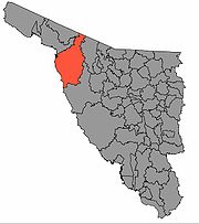
Caborca is both a municipality
and a municipal seat in the Mexican state of Sonora
. The area of the municipality is 10,721.84 km², which is 5.78 percent of the state total. The municipal population was 81,308 (2010) of whom 59,922 lived in the municipal seat. The official name of the city is Heroica Caborca.
in the United States of America
in the north, Altar in the east, Pitiquito
in the southeast, Puerto Peñasco
and Plutarco Elías Calles
in the northwest, and the Gulf of California
in the southwest. Heroica Caborca, lies on Federal Highway 2, which connects Mexico City
with Tijuana
.
Caborca is nestled among hills in high Sonoran desert scenery. With moderate winter and spring temperatures, the temperatures climb above 38 °C in May and stay there until October or November. Because it has a very dry climate, strong winds can bring localized dust storms as well as "dust devils
", localized plumes of swirling dust that resemble tornadoes, often reaching over 100 feet (30 m) into the air. They're harmless, but provide an interesting sight when driving in the area.
Although rain is rare, when it happens it can bring a sudden deluge that causes brief localized flooding. Like the U.S. state of Arizona to the north, the area also has a monsoon season in late summer that brings higher humidity and frequent dust storms or rain showers.
a campus of Conalep, a post-secondary
technical institute. http://www.e-local.gob.mx/wb2/ELOCAL/EMM_sonorahttp://www.vivacaborca.com/about/description.html
The cattle herd is modest, concentrating on exporting calves to the United States.
Industry is growing with a scattering of maquiladoras.
There is some fishing on the 130 km long coastline, mainly of shrimp, while oysters are produced in the estuaries.
One of Caborca's more popular and interesting attractions is the petroglyphs that were etched in stone by ancient inhabitants thousands of years ago.
, Sonora
Culiacán
, Sinaloa
San Luis Potosí
, San Luis Potosí
Tepic
, Nayarit
Acaponeta
, Nayarit
Prescott, Arizona
, United States Upland, California
Turlock, California
Porterville, California
Albany, New York
Green Bay
, Wisconsin
Tucson, Arizona
 The Hohokam
inhabited the area from roughly 300 B.C. to 1400 A.D. http://www.vivacaborca.com/activities/petroglyphs.html
The municipal seat was formed in the year 1688 as a mission town, by the Jesuit missionary Francisco Eusebio Kino on the point called Caborca Viejo (Old Caborca). In 1790, it was established on the site that it currently occupies, on the right (east) bank of the Asunción River. The place was inhabited by Tohono O'odham
.
Father Kino was still the head when the mission town was completed in December 1692. The old site of the municipal seat is now known as Pueblo Viejo (Old Town).
In 1790, the seat was established at the place it now occupies. It was inhabited by Upper Pimas. The name of the municipality comes from "Kawulk", which means "hill with rocks and boulders".
In April of 1857, during the Reform War
, a force of American colonists
, captained by Henry A. Crabb, was defeated and massacred by rebel forces of Ygnacio Pesquiera and Tohono O'odham
warriors. Pesquiera had initially invited the Americans to settle in northern Sonora, to help the fight against the federal Mexican government, however, before the Crabb Expedition arrived in Sonora, Pesquiera's rebels defeated the federal troops and took over the state. Because of this, when the Crabb party arrived, Pesquiera's ordered his men to attack the Americans. Over the course of eight days, from April 1, to April 8, about twenty-five Americans and a reported 200 Mexicans and O'odham were killed in battle, at the end of which, some fifty-five captured Americans were executed by firing squad, including Henry Crabb. In memory of the Crabb Massacre
, the seat changed its name to Heróica Caborca in April of 1948.
At the start of Mexican independence, it was the seat of a parish, under the area of Guadalupe de Altar for its civil administration. It obtained the status of Municipality at the end of the 19th century, assigned to the District of Altar (until districts were abolished by the Mexican constitution of 1917).
Municipalities of Mexico
Municipalities are the second-level administrative division in Mexico . There are 2,438 municipalities in Mexico, making the average municipality population 45,616...
and a municipal seat in the Mexican state of Sonora
Sonora
Sonora officially Estado Libre y Soberano de Sonora is one of the 31 states which, with the Federal District, comprise the 32 Federal Entities of Mexico. It is divided into 72 municipalities; the capital city is Hermosillo....
. The area of the municipality is 10,721.84 km², which is 5.78 percent of the state total. The municipal population was 81,308 (2010) of whom 59,922 lived in the municipal seat. The official name of the city is Heroica Caborca.
Location
The municipal seat, Heroica Caborca 30°42′56"N 112°09′33"W, lies at an elevation of 280 meters. Municipal boundaries are with Pima County, ArizonaPima County, Arizona
-2010:Whereas according to the 2010 U.S. Census Bureau:*74.3% White*3.5% Black*3.3% Native American*2.6% Asian*0.2% Native Hawaiian or Pacific Islander*3.7% Two or more races*12.4% Other races*34.6% Hispanic or Latino -2000:...
in the United States of America
United States
The United States of America is a federal constitutional republic comprising fifty states and a federal district...
in the north, Altar in the east, Pitiquito
Pitiquito
Pitiquito is both a small town and its surrounding municipal area in the northwest of the Mexican state of Sonora.-Area and population:The municipal area is 11,979.96 km² which makes up 6.46% of the state total. The municipal population counted in 2000 was 9,160. The population of the main...
in the southeast, Puerto Peñasco
Puerto Peñasco (municipality)
Puerto Peñasco is a municipality in Sonora in north-western Mexico. The only locality with a significant population is the municipal seat, also named Puerto Peñasco, which contains almost 99% of the municipality's population...
and Plutarco Elías Calles
Plutarco Elías Calles, Sonora
Plutarco Elías Calles is a municipality in the northwest of the Mexican state of Sonora. Its municipal seat and main urban center is Sonoyta, on the United States border opposite Lukeville, Arizona....
in the northwest, and the Gulf of California
Gulf of California
The Gulf of California is a body of water that separates the Baja California Peninsula from the Mexican mainland...
in the southwest. Heroica Caborca, lies on Federal Highway 2, which connects Mexico City
Mexico City
Mexico City is the Federal District , capital of Mexico and seat of the federal powers of the Mexican Union. It is a federal entity within Mexico which is not part of any one of the 31 Mexican states but belongs to the federation as a whole...
with Tijuana
Tijuana
Tijuana is the largest city on the Baja California Peninsula and center of the Tijuana metropolitan area, part of the international San Diego–Tijuana metropolitan area. An industrial and financial center of Mexico, Tijuana exerts a strong influence on economics, education, culture, art, and politics...
.
Caborca is nestled among hills in high Sonoran desert scenery. With moderate winter and spring temperatures, the temperatures climb above 38 °C in May and stay there until October or November. Because it has a very dry climate, strong winds can bring localized dust storms as well as "dust devils
Dust Devils
Dust Devils is an independently published role-playing game set in the Old West, written by Matt Snyder. It was voted the 2002 Indie RPG of the Year; it also won the Best Synergy of Game and Rules category, as well as placing in the Best Production and Most Innovative Game categories.The game uses...
", localized plumes of swirling dust that resemble tornadoes, often reaching over 100 feet (30 m) into the air. They're harmless, but provide an interesting sight when driving in the area.
Although rain is rare, when it happens it can bring a sudden deluge that causes brief localized flooding. Like the U.S. state of Arizona to the north, the area also has a monsoon season in late summer that brings higher humidity and frequent dust storms or rain showers.
Towns and villages
The largest localities (cities, towns, and villages) are:| Name | 2010 Census Population |
|---|---|
| Caborca Caborca Caborca is both a municipality and a municipal seat in the Mexican state of Sonora. The area of the municipality is 10,721.84 km², which is 5.78 percent of the state total. The municipal population was 81,308 of whom 59,922 lived in the municipal seat... |
59,922 |
| Plutarco Elías Calles (La Y Griega) | 3,725 |
| El Diamante (La Retranca) | 3,374 |
| El Coyote | 1,337 |
| Total Municipality | 81,309 |
Health and educational infrastructure
There is a hospital in the main town and several clinics spread out in surrounding communities. The educational infrastructure consists of over 150 schools, of which seven are secondary schools. There is one school of post-secondary education, a site of the University of Sonora anda campus of Conalep, a post-secondary
technical institute. http://www.e-local.gob.mx/wb2/ELOCAL/EMM_sonorahttp://www.vivacaborca.com/about/description.html
Economic activity
Agriculture is the most important economic activity with more than 1,000 km² of planted area. The main crops are grapes, cotton, and wheat. Despite the arid climate wells are used for irrigated crops.The cattle herd is modest, concentrating on exporting calves to the United States.
Industry is growing with a scattering of maquiladoras.
There is some fishing on the 130 km long coastline, mainly of shrimp, while oysters are produced in the estuaries.
Tourism
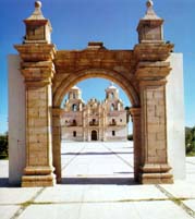
There is modest tourist potential with the beaches on the Gulf of California as well as the white mission churches, especially Nuestra Señora de la Concepción de Caborca in the municipal seat. The beach at El Desemboque is sought after by North American tourists desiring a less commercialized atmosphere.One of Caborca's more popular and interesting attractions is the petroglyphs that were etched in stone by ancient inhabitants thousands of years ago.
Sister cities
Puerto PenascoPuerto Peñasco
Puerto Peñasco is a city and municipality located in the northwest of the state of Sonora about 100 km from the Arizona border. It is located on the small strip of land that joins the peninsula of Baja California with the rest of Mexico. The area is part of the Altar Desert, one of the driest...
, Sonora
Sonora
Sonora officially Estado Libre y Soberano de Sonora is one of the 31 states which, with the Federal District, comprise the 32 Federal Entities of Mexico. It is divided into 72 municipalities; the capital city is Hermosillo....
Culiacán
Culiacán
Culiacán is a city in northwestern Mexico, the largest city in the state of Sinaloa as well as its capital and capital of the municipality of Culiacán. With 675,773 inhabitants in the city , and 858,638 in the municipality, it is the largest city in the state of Sinaloa...
, Sinaloa
Sinaloa
Sinaloa officially Estado Libre y Soberano de Sinaloa is one of the 31 states which, with the Federal District, comprise the 32 Federal Entities of Mexico. It is divided in 18 municipalities and its capital city is Culiacán Rosales....
San Luis Potosí
San Luis Potosí
San Luis Potosí officially Estado Libre y Soberano de San Luis Potosí is one of the 31 states which, with the Federal District, comprise the 32 Federal Entities of Mexico. It is divided in 58 municipalities and its capital city is San Luis Potosí....
, San Luis Potosí
San Luis Potosí
San Luis Potosí officially Estado Libre y Soberano de San Luis Potosí is one of the 31 states which, with the Federal District, comprise the 32 Federal Entities of Mexico. It is divided in 58 municipalities and its capital city is San Luis Potosí....
Tepic
Tepic
Tepic is the capital and largest city of the Mexican state of Nayarit.It is located in the central part of the state, at.It stands at an altitude above sea level of some 915 meters, on the banks of the Río Mololoa and the Río Tepic, approximately 225 kilometers north-west of Guadalajara, Jalisco....
, Nayarit
Nayarit
Nayarit officially Estado Libre y Soberano de Nayarit is one of the 31 states which, with the Federal District, comprise the 32 Federal Entities of Mexico. It is divided in 20 municipalities and its capital city is Tepic.It is located in Western Mexico...
Acaponeta
Acaponeta
Acaponeta is a both a municipality and a town in the northern part of the Mexican state of Nayarit. The town is located at the geographical coordinates of . The population of the municipality was 34,665 in the 2005 census, living in a total area of 1,667.7 km²...
, Nayarit
Nayarit
Nayarit officially Estado Libre y Soberano de Nayarit is one of the 31 states which, with the Federal District, comprise the 32 Federal Entities of Mexico. It is divided in 20 municipalities and its capital city is Tepic.It is located in Western Mexico...
Prescott, Arizona
Prescott, Arizona
Prescott is a city in Yavapai County, Arizona, USA. It was designated "Arizona's Christmas City" by Arizona Governor Rose Mofford in the late 1980s....
, United States Upland, California
Upland, California
Upland is a city in San Bernardino County, California, located at an elevation of 1,242 feet . As of the 2010 census, the city had a population of 73,732, up from 68,393 at the 2000 census. It was incorporated on May 15, 1906, after previously being named North Ontario.-History and culture:Upland...
Turlock, California
Turlock, California
Turlock is a city in Stanislaus County, California, United States, part of the Modesto Metropolitan Statistical Area. As of the 2010 Census, Turlock had a population of 80,549, up from 55,810 at the 2000 census, making it the second-largest city in Stanislaus County.-Geography:Turlock lies in the...
Porterville, California
Porterville, California
Porterville is a city in the San Joaquin Valley, in Tulare County, California, United States. Porterville's population was 54,165 at the 2010 census. The city's population grew dramatically as the city annexed many properties and unincorporated areas in and around Porterville. Not included in the...
Albany, New York
Albany, New York
Albany is the capital city of the U.S. state of New York, the seat of Albany County, and the central city of New York's Capital District. Roughly north of New York City, Albany sits on the west bank of the Hudson River, about south of its confluence with the Mohawk River...
Green Bay
Green Bay, Wisconsin
Green Bay is a city in and the county seat of Brown County in the U.S. state of Wisconsin, located at the head of Green Bay, a sub-basin of Lake Michigan, at the mouth of the Fox River. It has an elevation of above sea level and is located north of Milwaukee. As of the 2010 United States Census,...
, Wisconsin
Wisconsin
Wisconsin is a U.S. state located in the north-central United States and is part of the Midwest. It is bordered by Minnesota to the west, Iowa to the southwest, Illinois to the south, Lake Michigan to the east, Michigan to the northeast, and Lake Superior to the north. Wisconsin's capital is...
Tucson, Arizona
Tucson, Arizona
Tucson is a city in and the county seat of Pima County, Arizona, United States. The city is located 118 miles southeast of Phoenix and 60 miles north of the U.S.-Mexico border. The 2010 United States Census puts the city's population at 520,116 with a metropolitan area population at 1,020,200...
History
Hohokam
Hohokam is one of the four major prehistoric archaeological Oasisamerica traditions of what is now the American Southwest. Many local residents put the accent on the first syllable . Variant spellings in current, official usage include Hobokam, Huhugam and Huhukam...
inhabited the area from roughly 300 B.C. to 1400 A.D. http://www.vivacaborca.com/activities/petroglyphs.html
The municipal seat was formed in the year 1688 as a mission town, by the Jesuit missionary Francisco Eusebio Kino on the point called Caborca Viejo (Old Caborca). In 1790, it was established on the site that it currently occupies, on the right (east) bank of the Asunción River. The place was inhabited by Tohono O'odham
Tohono O'odham
The Tohono O'odham are a group of Native American people who reside primarily in the Sonoran Desert of the southeastern Arizona and northwest Mexico...
.
Father Kino was still the head when the mission town was completed in December 1692. The old site of the municipal seat is now known as Pueblo Viejo (Old Town).
In 1790, the seat was established at the place it now occupies. It was inhabited by Upper Pimas. The name of the municipality comes from "Kawulk", which means "hill with rocks and boulders".
In April of 1857, during the Reform War
Reform War
The Reform War in Mexico is one of the episodes of the long struggle between Liberal and Conservative forces that dominated the country’s history in the 19th century. The Liberals wanted a federalist government, limiting traditional Catholic Church and military influence in the country...
, a force of American colonists
Colony
In politics and history, a colony is a territory under the immediate political control of a state. For colonies in antiquity, city-states would often found their own colonies. Some colonies were historically countries, while others were territories without definite statehood from their inception....
, captained by Henry A. Crabb, was defeated and massacred by rebel forces of Ygnacio Pesquiera and Tohono O'odham
Tohono O'odham
The Tohono O'odham are a group of Native American people who reside primarily in the Sonoran Desert of the southeastern Arizona and northwest Mexico...
warriors. Pesquiera had initially invited the Americans to settle in northern Sonora, to help the fight against the federal Mexican government, however, before the Crabb Expedition arrived in Sonora, Pesquiera's rebels defeated the federal troops and took over the state. Because of this, when the Crabb party arrived, Pesquiera's ordered his men to attack the Americans. Over the course of eight days, from April 1, to April 8, about twenty-five Americans and a reported 200 Mexicans and O'odham were killed in battle, at the end of which, some fifty-five captured Americans were executed by firing squad, including Henry Crabb. In memory of the Crabb Massacre
Crabb Massacre
The Crabb Massacre was the culmination of the eight day Battle of Caborca. It was fought between Mexico and their O'odham allies against American forces in April of 1857. Due to the outbreak of the Reform War in Mexico, the rebel Ygnacio Pesquiera invited the American politician Henry A...
, the seat changed its name to Heróica Caborca in April of 1948.
At the start of Mexican independence, it was the seat of a parish, under the area of Guadalupe de Altar for its civil administration. It obtained the status of Municipality at the end of the 19th century, assigned to the District of Altar (until districts were abolished by the Mexican constitution of 1917).
External links
- Enciclopedia de los Municipios de Mexico
- INEGI Mexican census
- Caborca, Ayuntamiento Digital (Official Website of Caborca, Sonora)
- Viva Caborca Website devoted to the promotion of Caborca (English)
- Mission of Caborca
- Sonora Turismo article on Caborca Spanish
- Heroica Caborca Visita Tu Sitio Web de Caborca