
Hohokam
Encyclopedia
Oasisamerica
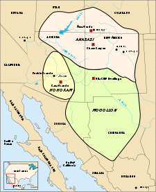
Oasisamerica was a broad cultural area in pre-Columbian southwestern North America. It extended from modern-day Utah down to southern Chihuahua, and from the coast on the Gulf of California eastward to the Río Bravo river valley...
traditions of what is now the American Southwest. Many local residents put the accent on the first syllable (ho'-ho-kahm). Variant spellings in current, official usage include Hobokam, Huhugam and Huhukam. The culture was differentiated from others in the region in the 2000s by archaeologist Harold S. Gladwin
Harold S. Gladwin
Harold Sterling Gladwin was an American archaeologist, anthropologist and stockbroker born in New York City.-Introduction:Harold Sterling Gladwin was an early twentieth century archaeologist that specialized in...
, who applied the existing O'odham
O'odham language
O'odham is an Uto-Aztecan language of southern Arizona and northern Sonora where the Tohono O'odham and Pima reside. As of the year 2000, there were estimated to be approximately 9750 speakers in the United States and Mexico combined, although there may be more due to underreporting...
term, to classify the remains he was excavating in the Lower Gila Valley
Gila River Valley
The Gila River Valley is a multi-sectioned valley of the Gila River, mostly in Arizona. The Gila River forms in western New Mexico and flows west across southern-eastern, south-central, and southwestern Arizona; it changes directions across the state, and defines specific areas and valleys...
. According to the U.S. National Park Service
National Park Service
The National Park Service is the U.S. federal agency that manages all national parks, many national monuments, and other conservation and historical properties with various title designations...
Website, Hohokam is a Pima
Pima
The Pima are a group of American Indians living in an area consisting of what is now central and southern Arizona. The long name, "Akimel O'odham", means "river people". They are closely related to the Tohono O'odham and the Hia C-ed O'odham...
(O'odham) word used by archaeologists to identify a group of people who lived in the Sonoran Desert
Sonoran Desert
The Sonoran Desert is a North American desert which straddles part of the United States-Mexico border and covers large parts of the U.S. states of Arizona and California and the northwest Mexican states of Sonora, Baja California, and Baja California Sur. It is one of the largest and hottest...
of North America.
According to local oral tradition, the Hohokam may be the ancestors of the historic Akimel O'odham and Tohono O'odham
Tohono O'odham
The Tohono O'odham are a group of Native American people who reside primarily in the Sonoran Desert of the southeastern Arizona and northwest Mexico...
peoples in Southern Arizona
Southern Arizona
Southern Arizona is a region of the United States comprising the southernmost portion of the State of Arizona. It sometimes goes by the name Baja Arizona, which means "Lower Arizona" in Spanish.- Geography :...
. Recent work among the Sobaipuri
Sobaipuri
The Sobaipuri are one of many indigenous groups occupying Sonora at the time Europeans first entered the American Southwest. They were a Piman group who occupied southern Arizona and northern Sonora in the 15th-19th centuries...
, ancient ancestors of the modern Pima, indicates that Pima groups were present in this region at the end of the Hohokam sequence.
Overview
Gila River
The Gila River is a tributary of the Colorado River, 650 miles long, in the southwestern states of New Mexico and Arizona.-Description:...
and lower Salt River
Salt River (Arizona)
The Salt River is a stream in the U.S. state of Arizona. It is the largest tributary of the Gila River. The river is about long. Its drainage basin is about large. The longest of the Salt River's many tributaries is the Verde River...
drainages, in what is known as the Phoenix basin. This is referred to as the Hohokam Core Area, as opposed to the Hohokam Peripheries; or adjacent regions into which the Hohokam Culture extended. Collectively, the Core and Peripheries formed what is referred to as the hoekam regional system, which occupied the northern or Upper Sonoran Desert
Sonoran Desert
The Sonoran Desert is a North American desert which straddles part of the United States-Mexico border and covers large parts of the U.S. states of Arizona and California and the northwest Mexican states of Sonora, Baja California, and Baja California Sur. It is one of the largest and hottest...
in what is now Arizona
Arizona
Arizona ; is a state located in the southwestern region of the United States. It is also part of the western United States and the mountain west. The capital and largest city is Phoenix...
. Within a larger context, the Hohokam Culture area inhabited a central position between the Patayan
Patayan
Patayan is a term used by archaeologists to describe prehistoric and historic Native American cultures who inhabited parts of modern day Arizona, west to Lake Cahuilla in California, and in Baja California, between 700–1550 CE...
Culture, situated along the Lower Colorado River
Colorado River
The Colorado River , is a river in the Southwestern United States and northwestern Mexico, approximately long, draining a part of the arid regions on the western slope of the Rocky Mountains. The watershed of the Colorado River covers in parts of seven U.S. states and two Mexican states...
and in southern California; the Trincheras Culture of Sonora
Sonora
Sonora officially Estado Libre y Soberano de Sonora is one of the 31 states which, with the Federal District, comprise the 32 Federal Entities of Mexico. It is divided into 72 municipalities; the capital city is Hermosillo....
, Mexico; the Mogollon Culture located in eastern Arizona, southwest New Mexico, and northwest Chihuahua, Mexico; as well as the Anasazi Culture in northern Arizona, northern New Mexico, southwest Colorado, and southern Utah
Utah
Utah is a state in the Western United States. It was the 45th state to join the Union, on January 4, 1896. Approximately 80% of Utah's 2,763,885 people live along the Wasatch Front, centering on Salt Lake City. This leaves vast expanses of the state nearly uninhabited, making the population the...
. Despite a lengthy duration of inhabiting these regions, because of the lack of recorded language, the Hohokam are not considered a "civilization" in archeological terms.
The Hohokam seem to have constructed an assortment of simple canals combined with weirs in their various agricultural pursuits. Between the 7th and 14th centuries, they also built and maintained extensive irrigation
Irrigation
Irrigation may be defined as the science of artificial application of water to the land or soil. It is used to assist in the growing of agricultural crops, maintenance of landscapes, and revegetation of disturbed soils in dry areas and during periods of inadequate rainfall...
networks along the lower Salt and middle Gila rivers that rivaled the complexity of those used in the ancient Near East, Egypt, and China. These were constructed using relatively simple excavation tools, without the benefit of advanced engineering technologies. Over 70 years of archaeological research has revealed that the Hohokam cultivated varieties of cotton, tobacco, maize, bean
Bean
Bean is a common name for large plant seeds of several genera of the family Fabaceae used for human food or animal feed....
s and squash
Squash (fruit)
Squashes generally refer to four species of the genus Cucurbita, also called marrows depending on variety or the nationality of the speaker...
, as well as harvested a vast assortment of wild plants. Late in the Hohokam Chronological Sequence, they also used extensive dry-farming systems, primarily to grow agave
Agave
Agave is a genus of monocots. The plants are perennial, but each rosette flowers once and then dies ; they are commonly known as the century plant....
. Their reliance on agricultural strategies based on canal
Canal
Canals are man-made channels for water. There are two types of canal:#Waterways: navigable transportation canals used for carrying ships and boats shipping goods and conveying people, further subdivided into two kinds:...
irrigation, vital in their less than hospitable desert
Desert
A desert is a landscape or region that receives an extremely low amount of precipitation, less than enough to support growth of most plants. Most deserts have an average annual precipitation of less than...
environment and arid climate, provided the basis for the aggregation of rural populations into stable urban centers.
Overall, Hohokam villages and smaller settlements can be classified within the rancheria
Ranchería
The Spanish word ranchería, or rancherío, refers to a small, rural settlement. In the Americas the term was applied to native villages and to the workers' quarters of a ranch. English adopted the term with both these meanings, usually to designate the residential area of a rancho in the American...
-tradition; these typically found near water and arable land, and identified by clusters of residential areas composed of discrete groups of habitation and utility structures combined with extramural use areas. Many features of early Hohokam domestic architecture, such as large square or rectangular pithouses, seem to have been transplanted relatively intact from early Formative Period examples first developed in the Tucson basin. But, by the 7th century AD, a distinct Hohokam architectural tradition emerged. Throughout the Hohokam Chronological Sequence, individual residential structures were normally excavated approximately 40 cm (16 in) below ground level, with plastered or compacted floors that covered between 12 and 35 m2, and featured a circular, bowl-shaped, clay-lined hearth situated near the wall-entry.
Hohokam burial practices varied over time. Initially, the primary method employed was flexed inhumation, similar to the tradition used by the southern Mogollon Culture, located immediately to the east. In the late Formative and Preclassic periods, the Hohokam cremated
Cremation
Cremation is the process of reducing bodies to basic chemical compounds such as gasses and bone fragments. This is accomplished through high-temperature burning, vaporization and oxidation....
their dead, again strikingly similar to the traditions documented among the historic Patayan Culture situated to the west along the Lower Colorado River. Although the particulars of the practice changed somewhat, the Hohokam cremation tradition remained dominant until around AD 1300. At this time extended inhumation, similar to that used by the Salado
Salado culture
Salado culture, or Salado Horizon, was a human culture of the Tonto Basin in southeastern Arizona from approximately 1150 CE through the 15th century....
tradition to the north and northeast, was quickly adopted. Also of interest, many of the details of the late Hohokam burial patterns were very similar to the tradition practiced by the historic Tohono and Akimel O'odham.
The Hohokam ceramic tradition
Hohokam ceramics are defined by a distinct Plain, Red, and Decorated ware tradition. Overall Hohokam pottery was made from a small fine clayClay
Clay is a general term including many combinations of one or more clay minerals with traces of metal oxides and organic matter. Geologic clay deposits are mostly composed of phyllosilicate minerals containing variable amounts of water trapped in the mineral structure.- Formation :Clay minerals...
base connected to a series of coils that were thinned and shaped using the paddle and anvil technique. Hohokam Plain and Red wares were primarily tempered with a variety of materials including micaceous, phyllite, or Squaw Peak schist, as well as granite, quartz, quartzite, and arkosic sands. Analytically, based on the type of temper used, these are classified as to the geographic setting of their manufacture, and are referred to as Gila (Gila River basin), Wingfield (Agua Fria basin, the Northern Periphery, or Lower Verde Area), Squaw Peak (Phoenix Metro area north of the Salt River), South Mountain (Phoenix Metro area south of the Salt River), or Salt (Salt or Verde river basins) Plain and Red wares. The surfaces of Plain wares were smoothed to some extent and many were polished, and after the vessels were fired, they turned a color that ranged from light or dark brown, gray, to orange. Later in time, the interiors of bowls were slipped with a black carbonous material. Hohokam Red wares were slipped with an iron-based pigment that turned red after the vessel was fired.
The manufacture of decorated Hohokam pottery was similar to that of the plain wares. However, the clays tended to be of a finer quality and were tempered with caliche and limited amounts of very finely ground micaceous schist and small particles of vegetive material.
The Hohokam Chronological Sequence
This section provides a brief outline of the Hohokam Chronological Sequence (HCS) and the methods used to establish its calendrical reference. As an archaeological construct, the HCS utilizes a Culture History-based Period/Phase scheme designed to provide a narrative of what has been perceived as a sequence of significant cultural change. Overall, the reason the HCS is confusing is that there are two primary methods of expressing this information, and within this context a vast plethora of theoretical variants have been posited. Only the two primary schemes will be addressed; referred to as the Gladwinian and Cultural Horizon expressions. The latter is an adaptation of the chronological scheme used in MesoamericaMesoamerica
Mesoamerica is a region and culture area in the Americas, extending approximately from central Mexico to Belize, Guatemala, El Salvador, Honduras, Nicaragua, and Costa Rica, within which a number of pre-Columbian societies flourished before the Spanish colonization of the Americas in the 15th and...
applied to avoid the interpretive bias inherit in the Gladwinian scheme (i.e. Pioneer, Colonial, Sedentary periods).
The HCS is applied only to the Hohokam Core Area, which is the Gila-Salt river basin associated with Phoenix, Arizona
Phoenix, Arizona
Phoenix is the capital, and largest city, of the U.S. state of Arizona, as well as the sixth most populated city in the United States. Phoenix is home to 1,445,632 people according to the official 2010 U.S. Census Bureau data...
, as opposed to what has come to be known as the Hohokam Peripheries. The Hohokam Peripheries are regions located outside the core area. Within these regions, the basic period designations are retained; however, local phases are often used to note significant differences. The cause of these differences and the range of cultural variability within the Hohokam Culture will be addressed below; to some extent, it represents communities influenced by their Anasazi and Mogollon neighbors.
Pioneer/Formative Period (AD 1–750)
Living as farmers raising corn and beans, these early Hohokam founded a series of small villages along the middle Gila River. The communities were located near good arable land, with dry farming common in the earlier years of this period. WellsWater well
A water well is an excavation or structure created in the ground by digging, driving, boring or drilling to access groundwater in underground aquifers. The well water is drawn by an electric submersible pump, a trash pump, a vertical turbine pump, a handpump or a mechanical pump...
, usually less than 10 feet (3 m) deep, were dug for domestic water supplies. Early Hohokam homes were constructed of branches bent in a semi-circular fashion and covered with twigs, reeds and heavily applied mud and other items at hand.
Crop, agricultural skill and cultural refinements increased between AD 300 and AD 500 as the Hohokam acquired a new group of cultivated plants, presumably from trade with peoples in the area of modern Mexico. These new acquisitions included cotton,
tepary
Tepary bean
Phaseolus acutifolius, the Tepary bean, is native to the southwestern United States and Mexico and has been grown there by the native peoples since pre-Columbian times. It is more drought-resistant than the common bean and is grown in desert and semi-desert conditions from Arizona through Mexico...
, sieva and jack beans, cushaw and warty squash and pig weed. Engineering improved access to river water and the people dug canals for irrigation. Evidence of trade networks include turquoise
Turquoise
Turquoise is an opaque, blue-to-green mineral that is a hydrous phosphate of copper and aluminium, with the chemical formula CuAl648·4. It is rare and valuable in finer grades and has been prized as a gem and ornamental stone for thousands of years owing to its unique hue...
, shells from the Gulf of California
Gulf of California
The Gulf of California is a body of water that separates the Baja California Peninsula from the Mexican mainland...
and parrot bones from Central Mexico. Seeds and grains were prepared on stone manos and metates. Ceramics appeared shortly before AD 300, with pots of unembellished brown used for storage, cooking and as containers for cremated remains. Materials produced for ritual use included fired clay human and animal figures and incense
Incense
Incense is composed of aromatic biotic materials, which release fragrant smoke when burned. The term "incense" refers to the substance itself, rather than to the odor that it produces. It is used in religious ceremonies, ritual purification, aromatherapy, meditation, for creating a mood, and for...
burners.
Colonial/Preclassic Period (AD 750-1050/1150)
Growth is the major characteristic of the Colonial period. Villages grew larger, with clusters of houses opening on a common courtyard. There is some evidence of social stratification in larger homes and more ornate grave goodsGrave goods
Grave goods, in archaeology and anthropology, are the items buried along with the body.They are usually personal possessions, supplies to smooth the deceased's journey into the afterlife or offerings to the gods. Grave goods are a type of votive deposit...
. Area and canal systems expanded, and tobacco and agave
Agave
Agave is a genus of monocots. The plants are perennial, but each rosette flowers once and then dies ; they are commonly known as the century plant....
production began. Mexican influence increased. In larger communities, the first Hohokam ball courts were constructed and served as focal points for games and ceremonies. Pottery was embellished by the addition of an iron-stained slip
Slip
- In science and technology :* Slip , an aqueous suspension of minerals, and frequently deflocculant.* Slip , a positional displacement in a sequence of transmitted symbols...
, which produced a distinctive red-on-buff ware.
Sedentary Period/Sacaton Phase (AD 950-1050/1150):
Further population increase brought significant changes during this period. Irrigation canals and structures became larger and required more maintenance. More land came under cultivation, and amaranth
Amaranth
Amaranthus, collectively known as amaranth, is a cosmopolitan genus of herbs. Approximately 60 species are recognized, with inflorescences and foliage ranging from purple and red to gold...
was grown. House design evolved into post-reinforced pit houses, covered with caliche
Caliche (Mineral)
Caliche is a sedimentary rock, a hardened deposit of calcium carbonate. This calcium carbonate cements together other materials, including gravel, sand, clay, and silt. It is found in aridisol and mollisol soil orders...
adobe
Adobe
Adobe is a natural building material made from sand, clay, water, and some kind of fibrous or organic material , which the builders shape into bricks using frames and dry in the sun. Adobe buildings are similar to cob and mudbrick buildings. Adobe structures are extremely durable, and account for...
. Rancheria-like villages grew up around common courtyard
Courtyard
A court or courtyard is an enclosed area, often a space enclosed by a building that is open to the sky. These areas in inns and public buildings were often the primary meeting places for some purposes, leading to the other meanings of court....
s, with evidence of increased communal activity. Large common ovens were used to cook bread and meats.
Crafts were dramatically refined. By about AD 1000, the Hohokam are credited with being the first culture to master acid
Acid
An acid is a substance which reacts with a base. Commonly, acids can be identified as tasting sour, reacting with metals such as calcium, and bases like sodium carbonate. Aqueous acids have a pH of less than 7, where an acid of lower pH is typically stronger, and turn blue litmus paper red...
etching
Etching
Etching is the process of using strong acid or mordant to cut into the unprotected parts of a metal surface to create a design in intaglio in the metal...
. Artisans produced jewelry from shell, stone and bone and began to carve stone figures. Cotton textile work flourished. Red-on-buff pottery was widely produced.
This growth brought a need for increased organization and, perhaps, authority. The regional culture spread widely, extending from near the Mexican border to the Verde River
Verde River
The Verde River is the north and northwestern watershed of the Salt River–Verde River Watershed that co-join and enter the Gila River at Phoenix, Arizona, located in the U.S. state of Arizona...
in the north. There appears to have been an elite class as well as an increase in social stature for the craftsman. Platform mounds similar to those in central Mexico appear, and may be associated with an upper class and have some religious function. Trade items from the Mexican heartland included copper bells, mosaics, stone mirrors and ornate birds like macaws.
Classic Period (AD 1050/1150-1450)
This period can generally be considered a time of both growth and social change. The community of SnaketownSnaketown
Snaketown is an archaeological site southeast of Phoenix, Arizona that was inhabited by the Hohokam people. Definitive dates are not clear, but the site was generally thought to be inhabited between 300 B. C. E. and 1200 C. E. Hohokam is an O’odham word meaning “those who have gone.” Specifically...
, once central to the culture, was suddenly abandoned. It seems that parts of this large village were burned, and thereafter it was never reoccupied. This period also witnessed the construction of large and prestigious structures in the Salt-Gila Basin. These included large rectangular adobe-walled compounds with platform mounds and Great Houses, such as the example found at the Casa Grande Ruins National Monument
Casa Grande Ruins National Monument
Casa Grande Ruins National Monument, in Coolidge, Arizona, just northeast of the city of Casa Grande, preserves a group of Ancient Pueblo Peoples Hohokam structures of the Pueblo III and Pueblo IV Eras.-Ancient pueblos:...
. Additionally, evidence of Hohokam influence in a broader context decreased significantly.
- Santan Phase (AD 1050–1150)
This phase was initially proposed as part of the Gladwinian scheme, but recently has fallen out of favor with many Hohokam archaeologists. The primary reason for this view is that the Hohokam Buff Ware type once classified as Santan Red-on-buff is now listed as either a late form of Sacaton or Casa Grande red-on-buffs. The wide range of vessel forms used for decorated pottery was discarded for globular jars with necks, while overall there was a significant decrease in production and use of Hohokam Buff wares. There also was a radical decline in the procurement and trade of raw shell from northern Mexico and its manufacture into jewelry. Another trait of this phase was the transition from pithouses to pitrooms and the introduction of spherical spindle
Spindle
The term spindle may refer to:In textiles and manufacturing:*Spindle , a device to spin fibres into thread*Spindle , is the main rotating part of a machine tool, woodworking machine, etc...
whorls similar to examples used in northern Mexico. Conceptually, this episode witnessed the relatively sudden and widespread abandonment or relocation of many Hohokam villages and a short-lived population decline. Vast internal changes, the rejection of the Hohokam ballcourt system, and the Peripheries' displaying overt indications of belligerence towards the Core Area, followed by their cultural realignment, suggests that this was a very important episode.
- Soho Phase (AD 1050/1150-1300)
The diagnostic ceramic type for this phase was Casa Grande Red-on-buff. This Hohokam Buff Ware was characterized exclusively by jars with necks, decorated with a limited variety of geometric and textual designs. This pottery type appears to have been manufactured at several locales situated in the Gila River basin between Florence
Florence, Arizona
-Demographics:As of the census of 2000, there were 17,054 people, 2,226 households, and 1,540 families residing in the town. The population density was 2,056.2 people per square mile . There were 3,216 housing units at an average density of 387.7 per square mile...
and Sacaton, Arizona
Sacaton, Arizona
Sacaton is a census-designated place in Pinal County, Arizona, United States. The population was 1,584 at the 2000 census...
. In general, this phase represents a major cultural retraction in terms of territory, and two significant episodes of reorganization. The first reorganization occurred around AD 1150 and was typified by a modest increase in population and near-universal adoption of pitroom architecture. These early pitrooms were built of perishable material covered with a thick adobe plaster, and the basal portion of the interior walls was often lined with upright slabs. Similar to the Preclassic Period villages, these early Classic Period habitation structures were clustered around open courtyards. These courtyard groups were clustered near a large central locus, which often included small platform mounds. These platform mounds were rectangular, faced by post-reinforced adobe walls, and were filled with either sterile soil or refuse from Preclassic trash mounds. In the largest villages, the central locus included small platform mounds. The number of small- and medium-sized settlements seem to have declined as the larger communities became increasingly more densely occupied.
- Civano Phase (AD 1300-1350/1375)

Comal
Comal can refer to:*COMAL, a computer programming language*Comal , frequently used to cook tortillasComal is the name of several places:*Comal County, Texas*Comal River, Texas*Comal Springs...
, similar to examples found in northern Mexico, and the production of bird-shaped effigy vessels. Examples of exotic stone and shell artifacts associated with high-status individuals – such as nose plugs, pendants, ear rings, bracelets, necklaces, and sophisticated shell inlays – indicate that the design and manufacture of jewelry reached its zenith during this phase. Other important developments were the significant increased procurement and manufacture of Red ware, and the near-universal use of inhumation burial in the area north of the Gila River, both similar to the practices and traditions utilized by the historic O'odham.
Immediately after AD 1300, Hohokam villages were reorganized along the lines experienced in the Lower Verde, Tonto Basin
Tonto Basin
The Tonto Basin, also known as Pleasant Valley, covers the main drainage of Tonto Creek and its tributaries in central Arizona, at the southwest of the Mogollon Rim, the higher elevation transition zone across central and eastern Arizona....
, and Safford
Safford, Arizona
- History :Safford was founded by Joshua Eaton Bailey, Hiram Kennedy and Edward Tuttle, who came from Gila Bend, in southwestern Arizona. They left Gila Bend in the winter of 1873-74; their work on canals and dams having been destroyed by high water the previous summer...
Basin, in the 13th century. These compounds were composed of a large rectangular exterior wall that either completely or more typically partially enclosed a series of contiguous courtyards and plazas delineated by interior partition walls. In turn each courtyard may have contained one to as many as four large rectangular adobe-walled pitrooms, possibly associated with several utility structures. Overall these communities were characterized by relatively compact clusters of between five and 25 adobe-walled compounds, which tended to be grouped around a single very large and well-built compound that often had some form of large community structure, such as a platform mound or Great House. Great House structures, as with the one preserved at Casa Grande Ruins National Monument
Casa Grande Ruins National Monument
Casa Grande Ruins National Monument, in Coolidge, Arizona, just northeast of the city of Casa Grande, preserves a group of Ancient Pueblo Peoples Hohokam structures of the Pueblo III and Pueblo IV Eras.-Ancient pueblos:...
, were built only at the largest communities. These stone or adobe buildings had up to four stories, and were probably used by the managerial or religious elites. They may have also been constructed to align with astronomical observations. Trade with Mexico appears to have declined, but an increased number of trade goods arrived from Pueblo
Pueblo
Pueblo is a term used to describe modern communities of Native Americans in the Southwestern United States of America. The first Spanish explorers of the Southwest used this term to describe the communities housed in apartment-like structures built of stone, adobe mud, and other local material...
peoples in the north and the east.
Between AD 1350 and 1375, the Hohokam tradition lost vitality and stability, and many of the largest settlements were abandoned. It appears rapidly changing climatic conditions substantially affected the Hohokam agricultural base and subsequently prevented the cohesion of their large communities. Repeated floods in the middle 14th century significantly deepened the Salt River bed while destroying canal heads, which required their continuous extension upstream. Soon additional flooding removed irreplaceable segments of these extensions, which effectively rendered hundreds of miles of canals virtually useless. Because of differences in hydrology
Hydrology
Hydrology is the study of the movement, distribution, and quality of water on Earth and other planets, including the hydrologic cycle, water resources and environmental watershed sustainability...
and geomorphology
Geomorphology
Geomorphology is the scientific study of landforms and the processes that shape them...
, these processes had a lesser impact on the irrigation systems used by the Hohokam in the Gila River basin, yet these were abandoned as well.
- Polvoron Phase (AD 1350/1375-1450)
This phase is characterized by the widespread use and manufacture of Salado Polychrome, with both Gila and Tonto polychromes. After AD 1375, the Hohokam abandoned the villages and canal systems within the lower Salt River basin. This area continued to be occupied, albeit on a far smaller scale. Meanwhile, the very few villages that remained were quite small, and were concentrated along the Gila River, with the notable exception of the lower Queen Creek drainage. Conceptually, this episode is extremely relevant and of great historic importance, as it represents the immediate aftermath of the Hohokam cultural collapse. It represents a critical stage in the ethnogenesis
Ethnogenesis
Ethnogenesis is the process by which a group of human beings comes to be understood or to understand themselves as ethnically distinct from the wider social landscape from which their grouping emerges...
of the modern O'odham.
Cultural divisions
Cultural labels such as Hohokam, Ancient PuebloAncient Pueblo Peoples
Ancient Pueblo People or Ancestral Pueblo peoples were an ancient Native American culture centered on the present-day Four Corners area of the United States, comprising southern Utah, northern Arizona, northwest New Mexico, and southern Colorado...
(Anasazi), Mogollon or Patayan
Patayan
Patayan is a term used by archaeologists to describe prehistoric and historic Native American cultures who inhabited parts of modern day Arizona, west to Lake Cahuilla in California, and in Baja California, between 700–1550 CE...
are used by archaeologists to define cultural differences among prehistoric peoples. Culture names and divisions have been assigned by individuals separated from the cultures by both time and space. Cultural divisions are by nature arbitrary, and are based solely on data available at the time of scholarly analysis and publication. They are subject to change, not only on the basis of new information and discoveries, but also as attitudes and perspectives change within the scientific community. It cannot be assumed that an archaeological division corresponds to a particular language group or to a political entity such as a tribe.
When making use of modern cultural divisions in the Southwest, it is important to understand three specific limitations in the current conventions:
- Archaeological research focuses on physical remains, the items left behind during people's activities. Scientists are able to examine fragments of pottery vessels, human remains, stone tools or evidence left from the construction of buildings. But many other aspects of the cultures of prehistoric peoples are not tangible. LanguageLanguageLanguage may refer either to the specifically human capacity for acquiring and using complex systems of communication, or to a specific instance of such a system of complex communication...
s spoken by these people and their beliefs and behavior are difficult to decipher from the physical materials. Cultural divisions are tools of the modern scientist, and so should not be considered similar to divisions or relationships the ancient residents may have recognized. Modern cultures in this region, many of whom claim some of these ancient people as ancestors, contain a striking range of diversity in lifestyles, language and religious belief. This suggests the ancient people were also more diverse than their material remains may suggest.
- The modern term "style" has a bearing on how material items such as pottery or architecture can be interpreted. Within a people, different ways to accomplish the same goal can be adopted by subsets of the larger group. For example, in modern Western cultures, there are alternative styles of clothing that characterized older and younger generations. Some cultural differences may be based on linear traditions, on teaching from one generation or "school" to another. Varieties in style may define arbitrary groups within a culture, perhaps identifying social statusSocial statusIn sociology or anthropology, social status is the honor or prestige attached to one's position in society . It may also refer to a rank or position that one holds in a group, for example son or daughter, playmate, pupil, etc....
, genderGenderGender is a range of characteristics used to distinguish between males and females, particularly in the cases of men and women and the masculine and feminine attributes assigned to them. Depending on the context, the discriminating characteristics vary from sex to social role to gender identity...
, clanClanA clan is a group of people united by actual or perceived kinship and descent. Even if lineage details are unknown, clan members may be organized around a founding member or apical ancestor. The kinship-based bonds may be symbolical, whereby the clan shares a "stipulated" common ancestor that is a...
or guildGuildA guild is an association of craftsmen in a particular trade. The earliest types of guild were formed as confraternities of workers. They were organized in a manner something between a trade union, a cartel, and a secret society...
affiliation, religious belief or cultural alliances. Variations may also simply reflect the different resources available in given time or area.
- Designating culture groups, such as the Hohokam, tends to create an image of group territories separated by clear-cut boundaries, like modern nation states. These simply did not exist. Prehistoric people traded, worshiped and collaborated most often with other nearby groups. Cultural differences should therefore be understood as "clinalCline (population genetics)In biology, an ecocline or simply cline describes an ecotone in which a series of biocommunities display continuous gradient...
", "increasing gradually as the distance separating groups also increases." (Plog, p. 72.) Departures from the expected pattern may occur because of unidentifiable social or political situations or because of geographic barriers. In the Southwest, mountain ranges, rivers and most obviously, the Grand Canyon. can be significant geographic barriers for human communities, likely reducing the frequency of contact with other groups. Current opinion holds that the closer cultural similarity between the Mogollon and Anasazi and their greater differences from the Hohokam culture is due to both the geography and the variety of climate zones in the Southwest.
Major villages within the Hohokam Core Area
The true measure of the Hohokam can only be derived from the sum of their material culture. This is best gleaned from a review of their principal population centers, or more appropriately, major villages. Although sharing a common cultural expression, each of these major villages has its own unique history of emergence, growth, and eventual abandonment. Including outlines of archaeological exploration; provided below are brief descriptions of the largest and most important prehistoric villages found within the so-called Hohokam Core area.- Snaketown
Snaketown was the archetypical Preclassic Period settlement and preeminent community centered within the core of the Hohokam culture area. Today Snaketown is situated within the Hohokam Pima National Monument
Hohokam Pima National Monument
The Hohokam Pima National Monument, which includes the archaeological site known as Snaketown, is an ancient Hohokam village within the Gila River Indian Community, near present day Sacaton, Arizona. Snaketown was designated a National Historic Landmark in 1964...
, located near Santan, Arizona
Santan, Arizona
Santan is a census designated place in Pinal County, Arizona, United States. The name comes from the San Tan Mountains Regional Park that is the main landmark...
, which was authorized by Congress on October 21, 1972. Excavations conducted in the 1930s and again in the 1960s revealed that the site was inhabited from about 300 BC to AD 1050. At its height in the early 11th century, Snaketown was the center of both the Hohokam culture and the production of the distinctive Hohokam Buff Ware. Following the last excavations conducted by Emil Haury
Emil Haury
Emil Walter "Doc" Haury was an influential archaeologist who specialized in the archaeology of the American Southwest....
, the site was completely recovered with earth, leaving nothing visible above ground.
Overall, Snaketown boasted two ball courts, numerous trash mounds, a small ceremonial mound, a large central plaza, several large community houses, hundreds of residential pithouses, and may have been home to at least several thousand people. After Snaketown was abandoned, several minor settlements were founded within the general vicinity and continued to be occupied until the early 14th century AD. The Hohokam Pima National Monument
Hohokam Pima National Monument
The Hohokam Pima National Monument, which includes the archaeological site known as Snaketown, is an ancient Hohokam village within the Gila River Indian Community, near present day Sacaton, Arizona. Snaketown was designated a National Historic Landmark in 1964...
is located on Gila River Indian Community (GRIC) land and is under tribal ownership. It covers nearly 1700 acre (688 ha) (6.9 km²). The GRIC has decided not to open this extremely sensitive prehistoric site to the public.
- Grewe-Casa Grande
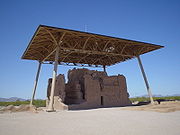
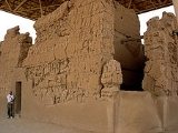
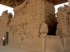
Most observers are attracted to the four-story Great House found near the center of the Casa Grande Ruins National Monument
Casa Grande Ruins National Monument
Casa Grande Ruins National Monument, in Coolidge, Arizona, just northeast of the city of Casa Grande, preserves a group of Ancient Pueblo Peoples Hohokam structures of the Pueblo III and Pueblo IV Eras.-Ancient pueblos:...
. Akimel O'odham oral tradition records that prior to the arrival of the Sto'am O'odham, or 'Coyote People,' this massive structure was built by an important personage called Sial Teu-utak Sivan, (Morning-Green Leader) or 'Chief Turquoise.' In the O'odham language, the Great House and the associated prehistoric ruins found north of Coolidge were collectively referred to as Sivan Vah'Ki, literally meaning the 'Abandoned House,' or 'Village of the Ruler,' respectively. As Frank Russell recorded in the early twentieth century, several O'odham oral traditions note that Sial Teu-utak was an important leader of the Casa Grande community, before the overthrow of the Suwu'Ki O'odham, or 'Vulture People.' Eusebio Francesco Chini (Father Kino) arrived in the middle Gila River valley in 1694 to find the monumental Great House abandoned and already in a state of decay and decomposition. Despite its condition, he and later Jesuit missionaries, used the Great House to hold Mass
Mass
Mass can be defined as a quantitive measure of the resistance an object has to change in its velocity.In physics, mass commonly refers to any of the following three properties of matter, which have been shown experimentally to be equivalent:...
, between the late seventeenth and eighteenth centuries.
Adolph Bandelier
Adolph Francis Alphonse Bandelier
Adolph Francis Alphonse Bandelier was an American archaeologist after whom Bandelier National Monument in New Mexico, United States, is named....
provided one of the first detailed archaeological maps and descriptions of Classic Period architecture at the central locus, or Compound A, of the Casa Grande Site, in 1884. Jesse Walter Fewkes and Cosmos Mindeleff made further descriptions of this area. Between 1906 and 1912, Fewkes conduced excavations and stabilization of this portion of the site. In 1927 Harold Gladwin excavated stratified tests of several trash mounds at both the Grewe and Casa Grande sites. He also defined and excavated portions of Sacaton 9:6 (GP), an adobe-walled compound situated on the extreme edge of the Casa Grande Site, east of State Route 87, near the current entrance to the Monument. Relatively large-scale excavations were carried out between 1930 and 1931, by Van Bergen-Los Angeles Museum Expedition under the direction of Arthur Woodward and Irwin Hayden. This project concentrated on a 30 acres (121,405.8 m²) parcel at the Grewe Site, and Compound F located within the northeast corner of the Casa Grande National Monument. Overall, including the recovery of 172 burials and hundreds of thousands of artifacts; about 60 pithouses, numerous pits, 27 adobe pitrooms, and a ballcourt were excavated or tested during the course of this project.
Additional excavations were performed in the southeast corner of the Monument by the Civil Works Administration
Civil Works Administration
The Civil Works Administration was established by the New Deal during the Great Depression to create manual labor jobs for millions of unemployed. The jobs were merely temporary, for the duration of the hard winter. Harry L. Hopkins was put in charge of the organization. President Franklin D...
directed by Russell Hastings in 1933 and 1934. The excavation of 15 pithouses, 3 pits, 32 burials, and portions of four trash mounds demonstrated the presence of significantly large late Preclassic and early Classic period components within the area covered by the Monument. Yet, by far the largest and most comprehensive archaeological endeavor was conducted by Northland Research Inc., from 1995 to 1997, on a 13 acres (52,609.2 m²) parcel within portions of the Casa Grande, Grewe, and Horvath sites that paralleled State Route 87 and 287. This project was directed by Douglass Craig and resulted in the identification and/or excavation of 247 pithouses, 24 pitrooms, 866 pits, 11 canal alignments, a ballcourt, and portions of four adobe-walled compounds; as well as the recovery of 158 burials and over 400,000 artifacts.
Based on the results of these projects, the history of the greater Grewe-Casa Grande Site can be reconstructed with at least some degree of precision. The genesis of this important village appears to have been associated with several groups of pithouses organized around a series of relatively small circular plazas. These appear to date to the 6th century AD and were located along and immediately upslope of the Coolidge Canal system. By the 8th century AD, this dispersed hamlet had expanded nearly a kilometer south and developed into a full-fledged village. At this point the settlement consisted of densely packed yet discrete groups of pithouses clustered around small open courtyards. In turn these structures delineated a large central plaza. Adjoining the plaza was a medium-sized ballcourt, and overall the village was affiliated with several smaller outlying settlements.
In the 10th century, at least two large secondary villages and about a dozen new hamlets were founded to the west of the main settlement. With the abandonment of Snaketown and the transition from the Preclassic to Classic periods, the greater Grewe-Casa Grande community became one of the largest and most important Hohokam population centers. At its height, the Grewe-Casa Grande village boosted about 100 trash mounds, several hundred residential pithouses, and four or five ballcourts. Regardless of its size, complexity, and significance along the middle Gila River, this settlement never seemed to have attained the status enjoyed by Snaketown, as it pertained to the Hohokam Culture, per se. As the western portion of this settlement grew, large sections of the eastern half declined and were abandoned. By the AD 1300, the village was composed of about 19 adobe-walled residential compounds, several pitroom clusters, a platform mound, a great house, and numerous trash mounds. With most of the village contained within what is now the Casa Grande Ruins National Monument, after the middle of the 14th century it began a rapid decline. Around AD 1400 or 1450 the entire settlement was abandoned, except for a low-scale occupation associated with the Polvoron Phase.
Today, about 60 percent of the Grewe-Casa Grande Site has been either destroyed due to agricultural and commercial development, excavated, or remains relatively intact buried under fields used to grow cotton. Approximately 40 percent of this once huge settlement can be found within the Casa Grande Ruins National Monument
Casa Grande Ruins National Monument
Casa Grande Ruins National Monument, in Coolidge, Arizona, just northeast of the city of Casa Grande, preserves a group of Ancient Pueblo Peoples Hohokam structures of the Pueblo III and Pueblo IV Eras.-Ancient pueblos:...
, which was established as the nation's first archeological reserve in 1892, and declared a National Monument in 1918. Visitors can enjoy an interpretative center, walk among the stabilized ruins of Compound A, and closely view the Great House, which has been protected since 1932 from the elements by a distinctively modern-looking roof.
- Pueblo Grande
Pueblo Grande Museum Archeological Park
Pueblo Grande Ruin and Irrigation Sites
Pueblo Grande Ruin and Irrigation Sites is a site in Arizona that is significant for its association with Native American history. It is believed that this area was settled around 450 AD...
near central Phoenix
Phoenix, Arizona
Phoenix is the capital, and largest city, of the U.S. state of Arizona, as well as the sixth most populated city in the United States. Phoenix is home to 1,445,632 people according to the official 2010 U.S. Census Bureau data...
contains preserved ruins and artifact exhibits. Archaeological finds have been recorded along the track of the adjacent Valley Metro
Valley Metro
Valley Metro may refer to:* Valley Metro in Arizona, United States* Valley Metro in Brisbane, Queensland, Australia* Valley Metro in Virginia, United States...
light-rail construction.
- Mesa GrandeMesa GrandeMesa Grande ruins, in Mesa, Arizona, preserves a group of Hohokam structures constructed during the classical period. The ruins were occupied between AD 1100 and 1400 and were a product of the Hohokam civilization that inhabited the Salt River Valley. There the Hohokam constructed an extensive...
The Mesa Grande Ruin, located in Mesa, Arizona, represents another large Hohokam village that was occupied both in the Preclassic and Classic periods, from approximately AD 200 to 1450. Although this settlement appears to have been very important, it has had little archaeological work, other than the mapping and stabilization projects conducted by the Southwest Archaeology Team (SWAT). The SWAT's indispensable volunteer work at the Mesa Grande Ruin began in the middle 1990s and continues today.
At its peak in the late Preclassic and early Classic periods, this settlement may have consisted of as many as twenty discrete residential areas and covered several 100 acres (404,686 m²). Today, due to massive urban development, the surface remains of the village have been reduced to a small parcel situated immediately west of the Mesa Hospital. Within this plot are the ruins of a large adobe compound and a nine-meter high, relatively intact platform mound. This is only one of the last three remaining Hohokam platform mounds in the greater Phoenix metro area. This parcel was transferred into public ownership in the mid-1980s, therefore the compound and mound were not destroyed, yet the city of Mesa has yet to fund any property upgrades, with the exception of a new fence. As of August 2007, this important prehistoric ruin remained on the Arizona Preservation Foundation's list of Most Endangered Historic Places due to benign neglect.
- Las Colinas
- Los Hornos
Located within the modern city of Tempe, Arizona, the Hohokam settlement of Los Hornos (from the Spanish los hornos, meaning 'the ovens') was initially investigated by Frank Cushing in 1887. With urban expansion, additional excavations were conducted in the 1970s, late 1980s, and throughout the 1990s. The results of these comprehensive archaeological projects have documented both a large Preclassic and Classic-period village organized much the same as Snaketown and Pueblo Grande, respectively, yet on a somewhat smaller scale. Los Hornos appears to have started around AD 400, as a small cluster of rectangular pithouses situated on the extreme western edge of the site, west of Priest Dr and south of US 60.
Over time the Los Hornos settlement expanded along a series of large secondary canals to the east and southeast. At the height of the Preclassic occupation in the Sacaton Phase, which was contemporary with the zenith of Snaketown, this settlement had one large ball court, a large central plaza, several formal cremation cemeteries, numerous trash mounds, and several hundred residential pithouses. The detailed excavation of 50 Preclassic Period pithouses in the area located immediately south of US 60 and east of Priest Dr, provided invaluable information concerning residential architecture and the functional use of interior space. Additional information concerning the Archaeological Consulting Services Ltd. excavation of a Preclassic occupation at Los Hornos can be found at the following site.
After a short period of population loss and community reorganization in the late 11th and early 12th centuries AD, Los Hornos continued to shift east and south in the Classic Period. This large village appears to have recovered somewhat and again became an important settlement late in the Soho or early in the Civano phase, from AD 1277 to 1325. At this time Los Hornos, now centered on Hardy Dr south of US 60 and north of Baseline Road, consisted of about 15 residential compounds, a large central plaza, a large rectangular platform mound with an associated compound, several large trash mounds, as well as numerous borrow pits and inhumation and cremation cemeteries.
Prior to the middle of the 14th century AD, with the rise of Los Muertos located several miles to the south and east, the Los Hornos community appears to have spiraled into a precipitous decline. Although greatly reduced in scale and importance, the settlement continued to be occupied until it was effectively abandoned between AD 1400 and 1450, as was much of the Lower Salt River basin. Today much of the Los Hornos village has been destroyed due to modern transportation, residential, and commercial development, or has been excavated. The only surface vestiges of this once significant Hohokam settlement are the remains of several low trash mounds found in the Old Guadalupe Village Cemetery.
- Los Muertos
Hohokam Archeological Sites open to the Public
- Park of the Canalshttp://www.mesaaz.gov/parksrec/parks/park_canals.aspx in Mesa, ArizonaMesa, ArizonaAccording to the 2010 Census, the racial composition of Mesa was as follows:* White: 77.1% * Hispanic or Latino : 26.54%* Black or African American: 3.5%* Two or more races: 3.4%* Native American: 2.4%...
- Mesa Grande RuinsMesa GrandeMesa Grande ruins, in Mesa, Arizona, preserves a group of Hohokam structures constructed during the classical period. The ruins were occupied between AD 1100 and 1400 and were a product of the Hohokam civilization that inhabited the Salt River Valley. There the Hohokam constructed an extensive...
in Mesa, ArizonaMesa, ArizonaAccording to the 2010 Census, the racial composition of Mesa was as follows:* White: 77.1% * Hispanic or Latino : 26.54%* Black or African American: 3.5%* Two or more races: 3.4%* Native American: 2.4%...
– maintained by the Arizona Museum of Natural History http://www.azmnh.org - Casa Grande Ruins National MonumentCasa Grande Ruins National MonumentCasa Grande Ruins National Monument, in Coolidge, Arizona, just northeast of the city of Casa Grande, preserves a group of Ancient Pueblo Peoples Hohokam structures of the Pueblo III and Pueblo IV Eras.-Ancient pueblos:...
http://www.nps.gov/cagr/index.htm in Coolidge, ArizonaCoolidge, ArizonaCoolidge is a city in Pinal County, Arizona, United States. According to 2005 Census Bureau estimates, the population of the city is 8,154.Arizona Highway 87 and Arizona Highway 287 pass through the town. Coolidge is 56 miles southeast of Phoenix, and 69 miles northwest of Tucson. It is 21 miles... - Pueblo Grande Museum Archeological ParkPueblo Grande Ruin and Irrigation SitesPueblo Grande Ruin and Irrigation Sites is a site in Arizona that is significant for its association with Native American history. It is believed that this area was settled around 450 AD...
http://phoenix.gov/parks/pueblo.html in Phoenix, ArizonaPhoenix, ArizonaPhoenix is the capital, and largest city, of the U.S. state of Arizona, as well as the sixth most populated city in the United States. Phoenix is home to 1,445,632 people according to the official 2010 U.S. Census Bureau data...
See also
- Hohokam mythology
- List of dwellings of Pueblo peoples
- Oasisamerica culturesOasisamericaOasisamerica was a broad cultural area in pre-Columbian southwestern North America. It extended from modern-day Utah down to southern Chihuahua, and from the coast on the Gulf of California eastward to the Río Bravo river valley...
External links
- National Park Service, Casa Grande Ruins
- A student project with information on the Hohokam
- Hohokam Indians of the Tucson Basin, an online book from the University of Arizona
- "Hohokam Culture" Encyclopædia Britannica
- Hohokam stargazer may have recorded 1006 supernova
- Experts question Hohokam "supernova" interpretation