Causeway
Encyclopedia

Body of water
A body of water or waterbody is any significant accumulation of water, usually covering the Earth or another planet. The term body of water most often refers to large accumulations of water, such as oceans, seas, and lakes, but it may also include smaller pools of water such as ponds, puddles or...
or wetland
Wetland
A wetland is an area of land whose soil is saturated with water either permanently or seasonally. Wetlands are categorised by their characteristic vegetation, which is adapted to these unique soil conditions....
.
Etymology
When first used, the word appeared in a form such as “causey way” making clear its derivation from the earlier form “causey”. This word seems to have come from the same source by two different routes. It derives ultimately, from the Latin for heel, calx, and most likely comes from the trampling technique to consolidate earthworksEarthworks (engineering)
Earthworks are engineering works created through the moving or processing of quantities of soil or unformed rock.- Civil engineering use :Typical earthworks include roads, railway beds, causeways, dams, levees, canals, and berms...
. Anciently, the construction was trodden down, one layer at a time, often by slaves
Slavery
Slavery is a system under which people are treated as property to be bought and sold, and are forced to work. Slaves can be held against their will from the time of their capture, purchase or birth, and deprived of the right to leave, to refuse to work, or to demand compensation...
or flocks of sheep. Today, this work is done by machines. The same technique would have been used for road embankments, raised river banks, sea banks and fortification
Fortification
Fortifications are military constructions and buildings designed for defence in warfare and military bases. Humans have constructed defensive works for many thousands of years, in a variety of increasingly complex designs...
earthworks. (The layers, though not the trampling action, can be seen in the Bayeux Tapestry
Bayeux Tapestry
The Bayeux Tapestry is an embroidered cloth—not an actual tapestry—nearly long, which depicts the events leading up to the Norman conquest of England concerning William, Duke of Normandy and Harold, Earl of Wessex, later King of England, and culminating in the Battle of Hastings...
: Building Hastings Castle.)
The second derivation route is simply the hard, trodden surface of a path. The name by this route came to be applied to a firmly-surfaced road. It is now little-used except in dialect and in the names of roads which were originally notable for their solidly-made surface.
The word is comparable in both meanings with the French
French language
French is a Romance language spoken as a first language in France, the Romandy region in Switzerland, Wallonia and Brussels in Belgium, Monaco, the regions of Quebec and Acadia in Canada, and by various communities elsewhere. Second-language speakers of French are distributed throughout many parts...
chaussée, from a form of which it reached English
English language
English is a West Germanic language that arose in the Anglo-Saxon kingdoms of England and spread into what was to become south-east Scotland under the influence of the Anglian medieval kingdom of Northumbria...
by way of Norman French
Norman language
Norman is a Romance language and one of the Oïl languages. Norman can be classified as one of the northern Oïl languages along with Picard and Walloon...
. The French adjective, chaussée, carries the meaning of having been given a hardened surface, and is used to mean either paved or shod. As a noun chaussée is used on the one hand for a metalled carriageway, and on the other for an embankment with or without a road. Other languages have a noun with similar dual meaning. In Welsh
Welsh language
Welsh is a member of the Brythonic branch of the Celtic languages spoken natively in Wales, by some along the Welsh border in England, and in Y Wladfa...
, it is sarn. The Welsh is relevant here, as it also has a verb, sarnu, meaning to trample. The trampling and ramming technique for consolidating earthworks was used in fortifications and there is a comparable, outmoded form of wall construction technique, used in such work and known as pisé, a word derived not from trampling but from ramming or tamping.
Sometimes confused with the "Coastway", name of a touristic zone in Panama city Panama.
A transport corridor that is carried instead on a series of arches, perhaps approaching a bridge, is a viaduct
Viaduct
A viaduct is a bridge composed of several small spans. The term viaduct is derived from the Latin via for road and ducere to lead something. However, the Ancient Romans did not use that term per se; it is a modern derivation from an analogy with aqueduct. Like the Roman aqueducts, many early...
. In the U.S. a short stretch of viaduct is called an overpass
Overpass
An overpass is a bridge, road, railway or similar structure that crosses over another road or railway...
. The distinction between the terms causeway and viaduct becomes blurred when flood-relief culvert
Culvert
A culvert is a device used to channel water. It may be used to allow water to pass underneath a road, railway, or embankment. Culverts can be made of many different materials; steel, polyvinyl chloride and concrete are the most common...
s are incorporated, though generally a causeway refers to a roadway supported mostly by earth or stone, while a bridge supports a roadway between piers (which may be embedded in embankments). Some low causeways across shore waters become inaccessible when covered at high tide
Tide
Tides are the rise and fall of sea levels caused by the combined effects of the gravitational forces exerted by the moon and the sun and the rotation of the Earth....
.
Engineering
Cofferdam
A cofferdam is a temporary enclosure built within, or in pairs across, a body of water and constructed to allow the enclosed area to be pumped out, creating a dry work environment for the major work to proceed...
: two parallel
Parallel (geometry)
Parallelism is a term in geometry and in everyday life that refers to a property in Euclidean space of two or more lines or planes, or a combination of these. The assumed existence and properties of parallel lines are the basis of Euclid's parallel postulate. Two lines in a plane that do not...
steel sheet pile
Deep foundation
A deep foundation is a type of foundation distinguished from shallow foundations by the depth they are embedded into the ground. There are many reasons a geotechnical engineer would recommend a deep foundation over a shallow foundation, but some of the common reasons are very large design loads, a...
or concrete
Concrete
Concrete is a composite construction material, composed of cement and other cementitious materials such as fly ash and slag cement, aggregate , water and chemical admixtures.The word concrete comes from the Latin word...
retaining wall
Retaining wall
Retaining walls are built in order to hold back earth which would otherwise move downwards. Their purpose is to stabilize slopes and provide useful areas at different elevations, e.g...
s, anchor
Anchor
An anchor is a device, normally made of metal, that is used to connect a vessel to the bed of a body of water to prevent the vessel from drifting due to wind or current. The word derives from Latin ancora, which itself comes from the Greek ἄγκυρα .Anchors can either be temporary or permanent...
ed to each other with steel cables or rods. This construction may also serve as a dyke that keeps two bodies of water apart, such as bodies with a different water level on each side, or with salt water
Seawater
Seawater is water from a sea or ocean. On average, seawater in the world's oceans has a salinity of about 3.5% . This means that every kilogram of seawater has approximately of dissolved salts . The average density of seawater at the ocean surface is 1.025 g/ml...
on one side and fresh water
Fresh Water
Fresh Water is the debut album by Australian rock and blues singer Alison McCallum, released in 1972. Rare for an Australian artist at the time, it came in a gatefold sleeve...
on the other. This may also be the primary purpose of a structure, the road providing a hardened crest for the dike, slowing erosion in the event of an overflow. It also provides access for maintenance as well perhaps, as a public service.
Examples
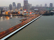
Singapore
Singapore , officially the Republic of Singapore, is a Southeast Asian city-state off the southern tip of the Malay Peninsula, north of the equator. An island country made up of 63 islands, it is separated from Malaysia by the Straits of Johor to its north and from Indonesia's Riau Islands by the...
and Malaysia (the Johor-Singapore Causeway
Johor-Singapore Causeway
The Johor–Singapore Causeway is a 1,056-metre causeway that links the city of Johor Bahru in Malaysia across the Straits of Johor to the town of Woodlands in Singapore. It serves as a road, rail, and pedestrian link, as well as water piping into Singapore.The causeway is connected to the...
), Bahrain
Bahrain
' , officially the Kingdom of Bahrain , is a small island state near the western shores of the Persian Gulf. It is ruled by the Al Khalifa royal family. The population in 2010 stood at 1,214,705, including 235,108 non-nationals. Formerly an emirate, Bahrain was declared a kingdom in 2002.Bahrain is...
and Saudi Arabia
Saudi Arabia
The Kingdom of Saudi Arabia , commonly known in British English as Saudi Arabia and in Arabic as as-Sa‘ūdiyyah , is the largest state in Western Asia by land area, constituting the bulk of the Arabian Peninsula, and the second-largest in the Arab World...
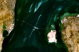
(25-km long King Fahd Causeway
King Fahd Causeway
The King Fahd Causeway is a causeway connecting Saudi Arabia and Bahrain. The idea of constructing the causeway was based on improving the links and bonds between Saudi Arabia and Bahrain...
) and Venice
Venice
Venice is a city in northern Italy which is renowned for the beauty of its setting, its architecture and its artworks. It is the capital of the Veneto region...
to the mainland, all of which carry roadways and railways. In the Netherlands
Netherlands
The Netherlands is a constituent country of the Kingdom of the Netherlands, located mainly in North-West Europe and with several islands in the Caribbean. Mainland Netherlands borders the North Sea to the north and west, Belgium to the south, and Germany to the east, and shares maritime borders...
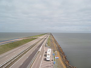
there are a number of prominent dykes which also double as causeways, including the Afsluitdijk
Afsluitdijk
The Afsluitdijk is a major causeway in the Netherlands, constructed between 1927 and 1933 and running from Den Oever on Wieringen in North Holland province, to the village of Zurich in Friesland province, over a length of and a width of 90 m, at an initial height of 7.25 m above sea-level.It is...
, Brouwersdam, and Markerwaarddijk. In Louisiana
Louisiana
Louisiana is a state located in the southern region of the United States of America. Its capital is Baton Rouge and largest city is New Orleans. Louisiana is the only state in the U.S. with political subdivisions termed parishes, which are local governments equivalent to counties...
, two very long bridges, called the Lake Pontchartrain Causeway
Lake Pontchartrain Causeway
The Lake Pontchartrain Causeway, or the Causeway, consists of two parallel bridges crossing Lake Pontchartrain in southern Louisiana, United States. The longer of the two bridges is long...
, stretch across Lake Pontchartrain
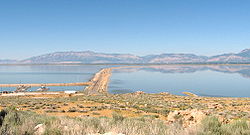
Lake Pontchartrain
Lake Pontchartrain is a brackish estuary located in southeastern Louisiana. It is the second-largest inland saltwater body of water in the United States, after the Great Salt Lake in Utah, and the largest lake in Louisiana. As an estuary, Pontchartrain is not a true lake.It covers an area of with...
for almost 38 km, making them the world's longest bridges (if total length is considered instead of span length). They are also the oldest causeways on the Gulf Coast that have never been put out of commission for an extended period of time following a Hurricane. In the Republic of Panama
Panama
Panama , officially the Republic of Panama , is the southernmost country of Central America. Situated on the isthmus connecting North and South America, it is bordered by Costa Rica to the northwest, Colombia to the southeast, the Caribbean Sea to the north and the Pacific Ocean to the south. The...
a causeway connects the islands of Perico, Flamenco, and Naos to Panama City
Panama City
Panama is the capital and largest city of the Republic of Panama. It has a population of 880,691, with a total metro population of 1,272,672, and it is located at the Pacific entrance of the Panama Canal, in the province of the same name. The city is the political and administrative center of the...
on the mainland. It also serves as a breakwater for ships entering the Panama Canal
Panama Canal
The Panama Canal is a ship canal in Panama that joins the Atlantic Ocean and the Pacific Ocean and is a key conduit for international maritime trade. Built from 1904 to 1914, the canal has seen annual traffic rise from about 1,000 ships early on to 14,702 vessels measuring a total of 309.6...
. The Aztec city-state of Tenochtitlan had causeways supporting roads and aqueducts. The oldest engineered road yet discovered is the Sweet Track
Sweet Track
The Sweet Track is an ancient causeway in the Somerset Levels, England. It was built in 3807 or 3806 BC and has been claimed to be the oldest road in the world. It was the oldest timber trackway discovered in Northern Europe until the 2009 discovery of a 6,000 year-old trackway in Belmarsh Prison...
in England
England
England is a country that is part of the United Kingdom. It shares land borders with Scotland to the north and Wales to the west; the Irish Sea is to the north west, the Celtic Sea to the south west, with the North Sea to the east and the English Channel to the south separating it from continental...
, dating from the 3800s BC
39th century BC
-Events:* The Post Track, an ancient causeway in the Somerset Levels, England, is built, ca. 3838 BC. It is one of the oldest engineered roads discovered in Northern Europe....
.
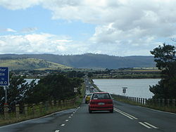
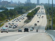
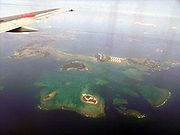
Causeways are also common in Florida
Florida
Florida is a state in the southeastern United States, located on the nation's Atlantic and Gulf coasts. It is bordered to the west by the Gulf of Mexico, to the north by Alabama and Georgia and to the east by the Atlantic Ocean. With a population of 18,801,310 as measured by the 2010 census, it...
, where low bridges may connect several man-made island
Island
An island or isle is any piece of sub-continental land that is surrounded by water. Very small islands such as emergent land features on atolls can be called islets, cays or keys. An island in a river or lake may be called an eyot , or holm...
s, often with a much higher bridge (or part of a single bridge) in the middle so that taller boat
Boat
A boat is a watercraft of any size designed to float or plane, to provide passage across water. Usually this water will be inland or in protected coastal areas. However, boats such as the whaleboat were designed to be operated from a ship in an offshore environment. In naval terms, a boat is a...
s may pass underneath safely. Causeways are most often used to connect the barrier island
Barrier island
Barrier islands, a coastal landform and a type of barrier system, are relatively narrow strips of sand that parallel the mainland coast. They usually occur in chains, consisting of anything from a few islands to more than a dozen...
s with the mainland
Mainland
Mainland is a name given to a large landmass in a region , or to the largest of a group of islands in an archipelago. Sometimes its residents are called "Mainlanders"...
.
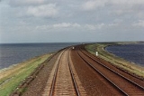
The Churchill Barriers
Churchill Barriers
The Churchill Barriers are a series of four causeways in the Orkney Islands, Scotland, with a total length of 1.5 miles . They link the Orkney Mainland in the north to the island of South Ronaldsay via Burray and the two smaller islands of Lamb Holm and Glimps Holm.The barriers were built in the...
in Orkney are of the most notable sets of causeways in Europe. Constructed in waters up to 18 metres deep, the four barriers link five islands on the eastern side of the natural harbour at Scapa Flow
Scapa Flow
right|thumb|Scapa Flow viewed from its eastern endScapa Flow is a body of water in the Orkney Islands, Scotland, United Kingdom, sheltered by the islands of Mainland, Graemsay, Burray, South Ronaldsay and Hoy. It is about...
. They were built during World War II
World War II
World War II, or the Second World War , was a global conflict lasting from 1939 to 1945, involving most of the world's nations—including all of the great powers—eventually forming two opposing military alliances: the Allies and the Axis...
as military defences for the harbour, on the orders of Winston Churchill
Winston Churchill
Sir Winston Leonard Spencer-Churchill, was a predominantly Conservative British politician and statesman known for his leadership of the United Kingdom during the Second World War. He is widely regarded as one of the greatest wartime leaders of the century and served as Prime Minister twice...
.
The Estrada do Istmo
Cotai
Cotai is a 5.2 km2 piece of newly reclaimed land between Taipa and Coloane islands in Macau, that has not yet been assigned to any of the freguesias. The Chinese and Portuguese names are a portmanteau of the two islands, Coloane and Taipa....
connecting the islands of Taipa
Taipa
Taipa is the smaller of the two islands in the Chinese special administrative region of Macao .- Geography :It is 2.5 kilometres from Macau Peninsula and east of the Lesser Hengqin Island of Zhuhai, Guangdong Province...
and Coloane
Coloane
Coloane is one of the two main islands of the Macau Special Administrative Region, located directly south of Macau's other main island, Taipa , and east of Hengqin Island of Zhuhai in Guangdong province....
in Macau
Macau
Macau , also spelled Macao , is, along with Hong Kong, one of the two special administrative regions of the People's Republic of China...
was initially built as a causeway. The sea on both sides of the causeway had become shallower as a result of silting, and mangroves had conquer the area. Later on land reclamation took place on both sides of the road and the area has subsequently be named Cotai
Cotai
Cotai is a 5.2 km2 piece of newly reclaimed land between Taipa and Coloane islands in Macau, that has not yet been assigned to any of the freguesias. The Chinese and Portuguese names are a portmanteau of the two islands, Coloane and Taipa....
and become home of several casino complexes.
Specific causeways around the world
Various causeways in the world:- Canso CausewayCanso CausewayThe Canso Causeway is a rock-fill causeway in Nova Scotia, Canada.The causeway crosses the Strait of Canso, connecting Cape Breton Island by road to the Nova Scotia peninsula...
, Nova ScotiaNova ScotiaNova Scotia is one of Canada's three Maritime provinces and is the most populous province in Atlantic Canada. The name of the province is Latin for "New Scotland," but "Nova Scotia" is the recognized, English-language name of the province. The provincial capital is Halifax. Nova Scotia is the...
, CanadaCanadaCanada is a North American country consisting of ten provinces and three territories. Located in the northern part of the continent, it extends from the Atlantic Ocean in the east to the Pacific Ocean in the west, and northward into the Arctic Ocean...
(45.6443°N 61.4184°W) - HindenburgdammHindenburgdammThe Hindenburgdamm is an 11 km-long causeway joining the North Frisian island of Sylt to mainland Schleswig-Holstein. Its coordinates are . It was opened on 1 June 1927 and is exclusively a railway corridor...
, GermanyGermanyGermany , officially the Federal Republic of Germany , is a federal parliamentary republic in Europe. The country consists of 16 states while the capital and largest city is Berlin. Germany covers an area of 357,021 km2 and has a largely temperate seasonal climate...
(54.8852°N 8.5404°W) - Johor-Singapore CausewayJohor-Singapore CausewayThe Johor–Singapore Causeway is a 1,056-metre causeway that links the city of Johor Bahru in Malaysia across the Straits of Johor to the town of Woodlands in Singapore. It serves as a road, rail, and pedestrian link, as well as water piping into Singapore.The causeway is connected to the...
(1.4520°N 103.7700°W) - Lake Ponchartrain, LouisianaLouisianaLouisiana is a state located in the southern region of the United States of America. Its capital is Baton Rouge and largest city is New Orleans. Louisiana is the only state in the U.S. with political subdivisions termed parishes, which are local governments equivalent to counties...
(30.1974°N 90.1205°W) - King Fahd CausewayKing Fahd CausewayThe King Fahd Causeway is a causeway connecting Saudi Arabia and Bahrain. The idea of constructing the causeway was based on improving the links and bonds between Saudi Arabia and Bahrain...
, BahrainBahrain' , officially the Kingdom of Bahrain , is a small island state near the western shores of the Persian Gulf. It is ruled by the Al Khalifa royal family. The population in 2010 stood at 1,214,705, including 235,108 non-nationals. Formerly an emirate, Bahrain was declared a kingdom in 2002.Bahrain is...
, Saudi ArabiaSaudi ArabiaThe Kingdom of Saudi Arabia , commonly known in British English as Saudi Arabia and in Arabic as as-Sa‘ūdiyyah , is the largest state in Western Asia by land area, constituting the bulk of the Arabian Peninsula, and the second-largest in the Arab World...
(26.1841°N 50.3241°W) - VeniceVeniceVenice is a city in northern Italy which is renowned for the beauty of its setting, its architecture and its artworks. It is the capital of the Veneto region...
(45.4535°N 12.2990°W) - Mahim CausewayMahim CausewayThe Mahim Causeway is a vital link road connecting the city of Mumbai with its northern suburbs. The causeway links the neighbourhoods of Mahim to the south with Bandra to the north....
, MumbaiMumbaiMumbai , formerly known as Bombay in English, is the capital of the Indian state of Maharashtra. It is the most populous city in India, and the fourth most populous city in the world, with a total metropolitan area population of approximately 20.5 million...
, India 19.04871°N 72.83816°E - SwarkestoneSwarkestoneSwarkestone is a village and civil parish in Derbyshire, England.Swarkestone has a very old village church, a full cricket pitch, the Crewe and Harpur pub, a canal with locks, moorings and canalside tea-rooms...
causeway, DerbyDerbyDerby , is a city and unitary authority in the East Midlands region of England. It lies upon the banks of the River Derwent and is located in the south of the ceremonial county of Derbyshire. In the 2001 census, the population of the city was 233,700, whilst that of the Derby Urban Area was 229,407...
, England, United Kingdom - Causeway across HaraldssundHaraldssundHaralssund is a town in the Faroe Islands situated on the island of Kunoy.*Population: 70*Postal code : FO 785*Location: *Municipality: Kunoyar...
, Faroe IslandsFaroe IslandsThe Faroe Islands are an island group situated between the Norwegian Sea and the North Atlantic Ocean, approximately halfway between Scotland and Iceland. The Faroe Islands are a self-governing territory within the Kingdom of Denmark, along with Denmark proper and Greenland... - Causeway across HvannasundHvannasundHvannasund is a village and municipality in the Faroe Islands, an autonomous region in Denmark....
, Faroe IslandsFaroe IslandsThe Faroe Islands are an island group situated between the Norwegian Sea and the North Atlantic Ocean, approximately halfway between Scotland and Iceland. The Faroe Islands are a self-governing territory within the Kingdom of Denmark, along with Denmark proper and Greenland... - MacArthur CausewayMacArthur CausewayThe General Douglas MacArthur Causeway is a six-lane causeway which connects Downtown, Miami, Florida and South Beach, Miami Beach via Biscayne Bay....
, FloridaFloridaFlorida is a state in the southeastern United States, located on the nation's Atlantic and Gulf coasts. It is bordered to the west by the Gulf of Mexico, to the north by Alabama and Georgia and to the east by the Atlantic Ocean. With a population of 18,801,310 as measured by the 2010 census, it...
, United StatesUnited StatesThe United States of America is a federal constitutional republic comprising fifty states and a federal district... - Giant's CausewayGiant's CausewayThe Giant's Causeway is an area of about 40,000 interlocking basalt columns, the result of an ancient volcanic eruption. It is located in County Antrim on the northeast coast of Northern Ireland, about three miles northeast of the town of Bushmills...
, Northern Ireland, United Kingdom
Precautions
Causeways affect currents and may therefore be involved in beach erosionErosion
Erosion is when materials are removed from the surface and changed into something else. It only works by hydraulic actions and transport of solids in the natural environment, and leads to the deposition of these materials elsewhere...
or changed deposition patterns; this effect has been a problem at the Hindenburgdamm
Hindenburgdamm
The Hindenburgdamm is an 11 km-long causeway joining the North Frisian island of Sylt to mainland Schleswig-Holstein. Its coordinates are . It was opened on 1 June 1927 and is exclusively a railway corridor...
in northern Germany. During hurricane seasons, the winds and rains of approaching tropical storms--as well as waves generated by the storm in the surrounding bodies of water--make traversing causeways problematic at best and impossibly dangerous during the fiercest parts of the storms. For this reason (and related reasons, such as the need to minimize traffic jams on both the roads approaching the causeway and the causeway itself), emergency evacuation
Emergency evacuation
Emergency evacuation is the immediate and rapid movement of people away from the threat or actual occurrence of a hazard. Examples range from the small scale evacuation of a building due to a bomb threat or fire to the large scale evacuation of a district because of a flood, bombardment or...
of island
Island
An island or isle is any piece of sub-continental land that is surrounded by water. Very small islands such as emergent land features on atolls can be called islets, cays or keys. An island in a river or lake may be called an eyot , or holm...
residents is a high priority for local, regional, and even national authorities.
See also
- The CausewayThe CausewayThe Causeway is the name of the traffic crossing of the Swan River in Western Australia at the eastern end of Perth Water. Made up of two bridges on either side of Heirisson Island, the crossing links the City of Perth and Victoria Park....
, Western AustraliaWestern AustraliaWestern Australia is a state of Australia, occupying the entire western third of the Australian continent. It is bounded by the Indian Ocean to the north and west, the Great Australian Bight and Indian Ocean to the south, the Northern Territory to the north-east and South Australia to the south-east... - Causey ArchCausey ArchThe Causey Arch is a bridge near Stanley in County Durham. It is the world’s oldest surviving railway bridge.It was built in 1725-26 by stonemason Ralph Wood, funded by a conglomeration of coal-owners known as the "'Grand Allies'" at a cost of £12,000...
, County DurhamCounty DurhamCounty Durham is a ceremonial county and unitary district in north east England. The county town is Durham. The largest settlement in the ceremonial county is the town of Darlington...
, EnglandEnglandEngland is a country that is part of the United Kingdom. It shares land borders with Scotland to the north and Wales to the west; the Irish Sea is to the north west, the Celtic Sea to the south west, with the North Sea to the east and the English Channel to the south separating it from continental... - Lake Pontchartrain CausewayLake Pontchartrain CausewayThe Lake Pontchartrain Causeway, or the Causeway, consists of two parallel bridges crossing Lake Pontchartrain in southern Louisiana, United States. The longer of the two bridges is long...
, Metairie, LouisianaMetairie, LouisianaMetairie is a census-designated place in Jefferson Parish, Louisiana, United States and is a major part of the New Orleans Metropolitan Area. Metairie is the largest community in Jefferson Parish. It is an unincorporated area that would be larger than most of the state's cities if it were...
,Southern; Mandeville, LouisianaMandeville, LouisianaMandeville is a city in St. Tammany Parish, Louisiana, United States. The population was 12,421 in 2008. Mandeville is located on the North Shore of Lake Pontchartrain, south of Interstate 12. It is across the lake from the city of New Orleans and its southshore suburbs...
, Northern. - KūlgrindaKulgrindaKūlgrinda is a hidden underwater stony road or ford across swamps and swampy areas used for defense in the history of Lithuania...
- Pulaski SkywayPulaski SkywayThe General Pulaski Skyway is a four-lane freeway composed of connected bridges in the northeastern part of the U.S. state of New Jersey, carrying the designation of U.S. Route 1/9 for most of its length. The landmark structure has a total length of with the longest bridge spanning...
- SacbeSacberight|thumb|Sacbe at Dzibilchaltun in the Yucatánthumb|right|Arch at the end of the sacbé, Kabah, YucatánSacbe, plural Sacbeob, or "white ways" are raised paved roads built by the Maya civilization of pre-Columbian Mesoamerica...