
Tyin
Encyclopedia
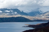
Tyin is a lake
in the southwest part of the Jotunheimen
mountain range in Norway
. The lake lies in Vang municipality in Oppland
county, although a small portion extends into Årdal
municipality in Sogn og Fjordane
county. The western border follows, for a large part, the border between Vang and Årdal
. In area it is 33.02 km². The lake serves as a reservoir
for Tyin kraftverk and the water level is regulated between 1082.84 and 1072.50 m above sea level. The volume is 0.313 km³.
Along the south side of the lake goes the national highway, riksvei 53, (Tyin–Årdal) and along the east side goes riksvei 252 (Tyin–Eidsbugarden
). The riksvei 252 is accessible from European route E16
via a 3 km link.
In 1869 the Norwegian Mountain Touring Association
(DNT) built its first hut, which was located on the shores of Lake Tyin. Today the DNT’s tourist huts make this area, just to the south of Jotunheim National Park
, one of the best developed touring areas in Europe. There are also a restricted number of private cabins by the lake.
. The meaning of the rivername is unknown.
Lake
A lake is a body of relatively still fresh or salt water of considerable size, localized in a basin, that is surrounded by land. Lakes are inland and not part of the ocean and therefore are distinct from lagoons, and are larger and deeper than ponds. Lakes can be contrasted with rivers or streams,...
in the southwest part of the Jotunheimen
Jotunheimen
Jotunheimen is a mountainous area of roughly 3,500 km² in Southern Norway and is part of the long range known as the Scandinavian Mountains. The 29 highest mountains in Norway are all in Jotunheimen, including the very highest - Galdhøpiggen...
mountain range in Norway
Norway
Norway , officially the Kingdom of Norway, is a Nordic unitary constitutional monarchy whose territory comprises the western portion of the Scandinavian Peninsula, Jan Mayen, and the Arctic archipelago of Svalbard and Bouvet Island. Norway has a total area of and a population of about 4.9 million...
. The lake lies in Vang municipality in Oppland
Oppland
is a county in Norway, bordering Sør-Trøndelag, Møre og Romsdal, Sogn og Fjordane, Buskerud, Akershus, Oslo and Hedmark. The county administration is in Lillehammer. Oppland is, together with Hedmark, one of the only two landlocked counties of Norway....
county, although a small portion extends into Årdal
Årdal
Årdal is a municipality in the county of Sogn og Fjordane, Norway. It is located in the traditional district of Sogn. The village of Årdalstangen is the administrative center of the municipality. Årdal was separated from Lærdal in 1860....
municipality in Sogn og Fjordane
Sogn og Fjordane
is a county in Norway, bordering Møre og Romsdal, Oppland, Buskerud, and Hordaland. The county administration is in the town of Hermansverk in Leikanger municipality while the largest town is Førde....
county. The western border follows, for a large part, the border between Vang and Årdal
Årdal
Årdal is a municipality in the county of Sogn og Fjordane, Norway. It is located in the traditional district of Sogn. The village of Årdalstangen is the administrative center of the municipality. Årdal was separated from Lærdal in 1860....
. In area it is 33.02 km². The lake serves as a reservoir
Reservoir
A reservoir , artificial lake or dam is used to store water.Reservoirs may be created in river valleys by the construction of a dam or may be built by excavation in the ground or by conventional construction techniques such as brickwork or cast concrete.The term reservoir may also be used to...
for Tyin kraftverk and the water level is regulated between 1082.84 and 1072.50 m above sea level. The volume is 0.313 km³.
Along the south side of the lake goes the national highway, riksvei 53, (Tyin–Årdal) and along the east side goes riksvei 252 (Tyin–Eidsbugarden
Eidsbugarden
Eidsbugarden is a tourist center which lies at the western end of Lake Bygdin in the Jotunheimen mountain range on the outskirts of Jotunheim National Park in Oppland, Norway. Eidsbugarden lies to the southeast in Jotunheim....
). The riksvei 252 is accessible from European route E16
European route E16
European route E 16 is the designation of a main west-east road through Northern Ireland, Scotland and Norway, from Derry to Oslo, via Glasgow, Edinburgh, previously by ferry to Bergen, Voss, through the Gudvanga Tunnel, Lærdal, through the Lærdal Tunnel, over Filefjell to Fagernes, Hønefoss,...
via a 3 km link.
In 1869 the Norwegian Mountain Touring Association
Norwegian Mountain Touring Association
The Norwegian Trekking Association is a Norwegian association which maintains mountain trails and cabins in Norway. The association was founded on 21 January 1868 with the scope "to help and develop tourism in this country". Today the goal is to work for simple, secure and environmentally friendly...
(DNT) built its first hut, which was located on the shores of Lake Tyin. Today the DNT’s tourist huts make this area, just to the south of Jotunheim National Park
Jotunheim National Park
Jotunheimen National Park is a national park in Norway, recognized as one of the country's premier hiking and fishing regions. The national park covers 1,151 km² and is part of the larger area Jotunheimen...
, one of the best developed touring areas in Europe. There are also a restricted number of private cabins by the lake.
The name
The name of the lake is derived from the name of the river Tya - the river that connects the lake to Årdalsvatnet and the SognefjordSognefjord
The Sognefjord is the largest fjord in Norway, and the second longest in the world. Located in Sogn og Fjordane county, it stretches inland to the small village of Skjolden...
. The meaning of the rivername is unknown.