
Geography of Brazil
Encyclopedia
| Geography of Brazil |
|---|
}}
|-
!align="center" bgcolor="lightblue" colspan="2"|Surface Area of Brazil
|-
! style="background:#f0f0f0;" align="left" valign="top"| Total
| style="background:#f0f0f0;" valign="top"| 8514877 km² (3,287,612.4 sq mi)
|-
!align="left" valign="top"| Land
|valign="top"| 8459417 km² (3,266,199.2 sq mi)
|-
! style="background:#f0f0f0;" align="left" valign="top"| Water
| style="background:#f0f0f0;" valign="top"| 55460 km² (21,413.2 sq mi)
|-
!align="center" valign="top" colspan="2"|Notes:
|-
!align="center" bgcolor="lightblue" colspan="2"|Boundaries
|-
! style="background:#f0f0f0;" align="left" valign="top"| Coastline
| style="background:#f0f0f0;" valign="top"| 7491 km (4,654.7 mi)
|-
!align="left" valign="top"| Total land boundary
|valign="top"| 16885 km (10,491.9 mi)
|-
! style="background:#f0f0f0;" align="left" valign="top"| Border countries
| style="background:#f0f0f0;" valign="top"|
- ArgentinaArgentinaArgentina , officially the Argentine Republic , is the second largest country in South America by land area, after Brazil. It is constituted as a federation of 23 provinces and an autonomous city, Buenos Aires...
1261 km (783.6 mi) - BoliviaBoliviaBolivia officially known as Plurinational State of Bolivia , is a landlocked country in central South America. It is the poorest country in South America...
3423 km (2,127 mi) - ColombiaColombiaColombia, officially the Republic of Colombia , is a unitary constitutional republic comprising thirty-two departments. The country is located in northwestern South America, bordered to the east by Venezuela and Brazil; to the south by Ecuador and Peru; to the north by the Caribbean Sea; to the...
1644 km (1,021.5 mi) - French GuianaFrench GuianaFrench Guiana is an overseas region of France, consisting of a single overseas department located on the northern Atlantic coast of South America. It has borders with two nations, Brazil to the east and south, and Suriname to the west...
730 km (453.6 mi) - GuyanaGuyanaGuyana , officially the Co-operative Republic of Guyana, previously the colony of British Guiana, is a sovereign state on the northern coast of South America that is culturally part of the Anglophone Caribbean. Guyana was a former colony of the Dutch and of the British...
1606 km (997.9 mi) - ParaguayParaguayParaguay , officially the Republic of Paraguay , is a landlocked country in South America. It is bordered by Argentina to the south and southwest, Brazil to the east and northeast, and Bolivia to the northwest. Paraguay lies on both banks of the Paraguay River, which runs through the center of the...
1365 km (848.2 mi) - PeruPeruPeru , officially the Republic of Peru , is a country in western South America. It is bordered on the north by Ecuador and Colombia, on the east by Brazil, on the southeast by Bolivia, on the south by Chile, and on the west by the Pacific Ocean....
2995 km (1,861 mi) - SurinameSurinameSuriname , officially the Republic of Suriname , is a country in northern South America. It borders French Guiana to the east, Guyana to the west, Brazil to the south, and on the north by the Atlantic Ocean. Suriname was a former colony of the British and of the Dutch, and was previously known as...
593 km (368.5 mi) - UruguayUruguayUruguay ,officially the Oriental Republic of Uruguay,sometimes the Eastern Republic of Uruguay; ) is a country in the southeastern part of South America. It is home to some 3.5 million people, of whom 1.8 million live in the capital Montevideo and its metropolitan area...
1068 km (663.6 mi) - VenezuelaVenezuelaVenezuela , officially called the Bolivarian Republic of Venezuela , is a tropical country on the northern coast of South America. It borders Colombia to the west, Guyana to the east, and Brazil to the south...
2200 km (1,367 mi)
|-
!align="center" bgcolor="lightblue" colspan="2"|Territories and claims
|-
|-
! style="background:#f0f0f0;" align="left" valign="top"|Islands
| style="background:#f0f0f0;" valign="top"|
- Fernando de NoronhaFernando de NoronhaFernando de Noronha is an archipelago of 21 islands and islets in the Atlantic Ocean, offshore from the Brazilian coast. The main island has an area of and had a population of 3,012 in the year 2010...
- Rocas AtollRocas AtollThe Rocas Atoll is an atoll in the Atlantic Ocean, belonging to the Brazilian State of Rio Grande do Norte. It is located approximately northeast of Natal and west of the archipelago of Fernando de Noronha. The atoll is of volcanic origin and coralline formation.-Description:The oval atoll is ...
- Saint Peter and Paul RocksSaint Peter and Paul RocksThe Saint Peter and Saint Paul Archipelago is a group of 15 small islets and rocks in the central equatorial Atlantic Ocean. It lies in the Intertropical Convergence Zone, a region of severe storms...
- Trindade and Martim Vaz IslandsTrindade and Martim VazTrindade and Martim Vaz is an archipelago located about 1,200 kilometers east of Vitória in the Southern Atlantic Ocean, belonging to the State of Espírito Santo, Brazil. The archipelago has a total area of 10.4 km² and a population of 32...
|-
!align="left" valign="top"|Informal claim
|valign="top"| Brazilian Antarctica
|-
!align="center" bgcolor="lightblue" colspan="2"|Maritime claims
|-
! style="background:#f0f0f0;" align="left" valign="top"| Contiguous zone
| style="background:#f0f0f0;" valign="top"| 24 nmi (44.4 km; 27.6 mi)
|-
!align="left" valign="top"| Continental shelf
|valign="top"| 200 nmi (370.4 km; 230.2 mi)
|-
! style="background:#f0f0f0;" align="left" valign="top"| Exclusive Economic Zone
Exclusive Economic Zone
Under the law of the sea, an exclusive economic zone is a seazone over which a state has special rights over the exploration and use of marine resources, including production of energy from water and wind. It stretches from the seaward edge of the state's territorial sea out to 200 nautical...
| style="background:#f0f0f0;" valign="top"| 200 nmi (370.4 km; 230.2 mi)
|-
!align="left" valign="top"| Territorial sea
|valign="top"| 12 nmi (22.2 km; 13.8 mi)
|-
!align="center" bgcolor="lightblue" colspan="2"|Land use
|-
! style="background:#f0f0f0;" align="left" valign="top"| Arable land
| style="background:#f0f0f0;" valign="top"| 6.93% (2005)
|-
!align="left" valign="top"| Permanent crop
|valign="top"| 0.89% (2005)
|-
! style="background:#f0f0f0;" align="left" valign="top"| Other
| style="background:#f0f0f0;" valign="top"| 92.18% (2005)
|-
!align="left" valign="top"| Irrigated land
|valign="top"| 29200 km² (11,274.2 sq mi) (2003)
|-
|}
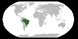
The country of Brazil occupies roughly half of South America
South America
South America is a continent situated in the Western Hemisphere, mostly in the Southern Hemisphere, with a relatively small portion in the Northern Hemisphere. The continent is also considered a subcontinent of the Americas. It is bordered on the west by the Pacific Ocean and on the north and east...
, bordering the Atlantic Ocean
Atlantic Ocean
The Atlantic Ocean is the second-largest of the world's oceanic divisions. With a total area of about , it covers approximately 20% of the Earth's surface and about 26% of its water surface area...
. Brazil covers a total area of 8514215 km² (3,287,356.8 sq mi) which includes 8456510 km² (3,265,076.8 sq mi) of land and 55455 km² (21,411.3 sq mi) of water. The highest point in Brazil is Pico da Neblina
Pico da Neblina
Pico da Neblina is the highest mountain in Brazil, above sea level, in the Serra do Imeri, a section of the Guiana Highlands on the Brazil–Venezuela border. As determined by a border survey expedition in 1962, its summit lies just within Brazilian territory, at a horizontal distance of only from...
at 2994 m (9,822.8 ft). Brazil is bordered by the countries of Argentina
Argentina
Argentina , officially the Argentine Republic , is the second largest country in South America by land area, after Brazil. It is constituted as a federation of 23 provinces and an autonomous city, Buenos Aires...
, Bolivia
Bolivia
Bolivia officially known as Plurinational State of Bolivia , is a landlocked country in central South America. It is the poorest country in South America...
, Colombia
Colombia
Colombia, officially the Republic of Colombia , is a unitary constitutional republic comprising thirty-two departments. The country is located in northwestern South America, bordered to the east by Venezuela and Brazil; to the south by Ecuador and Peru; to the north by the Caribbean Sea; to the...
, French Guiana
French Guiana
French Guiana is an overseas region of France, consisting of a single overseas department located on the northern Atlantic coast of South America. It has borders with two nations, Brazil to the east and south, and Suriname to the west...
, Guyana
Guyana
Guyana , officially the Co-operative Republic of Guyana, previously the colony of British Guiana, is a sovereign state on the northern coast of South America that is culturally part of the Anglophone Caribbean. Guyana was a former colony of the Dutch and of the British...
, Paraguay
Paraguay
Paraguay , officially the Republic of Paraguay , is a landlocked country in South America. It is bordered by Argentina to the south and southwest, Brazil to the east and northeast, and Bolivia to the northwest. Paraguay lies on both banks of the Paraguay River, which runs through the center of the...
, Peru
Peru
Peru , officially the Republic of Peru , is a country in western South America. It is bordered on the north by Ecuador and Colombia, on the east by Brazil, on the southeast by Bolivia, on the south by Chile, and on the west by the Pacific Ocean....
, Suriname
Suriname
Suriname , officially the Republic of Suriname , is a country in northern South America. It borders French Guiana to the east, Guyana to the west, Brazil to the south, and on the north by the Atlantic Ocean. Suriname was a former colony of the British and of the Dutch, and was previously known as...
, Uruguay
Uruguay
Uruguay ,officially the Oriental Republic of Uruguay,sometimes the Eastern Republic of Uruguay; ) is a country in the southeastern part of South America. It is home to some 3.5 million people, of whom 1.8 million live in the capital Montevideo and its metropolitan area...
and Venezuela
Venezuela
Venezuela , officially called the Bolivarian Republic of Venezuela , is a tropical country on the northern coast of South America. It borders Colombia to the west, Guyana to the east, and Brazil to the south...
.
Much of the climate is tropical, with the south being relatively temperate. The largest river in Brazil, and one of the longest in the world, is the Amazon
Amazon River
The Amazon of South America is the second longest river in the world and by far the largest by waterflow with an average discharge greater than the next seven largest rivers combined...
. The rainforest
Rainforest
Rainforests are forests characterized by high rainfall, with definitions based on a minimum normal annual rainfall of 1750-2000 mm...
that covers the Amazon Basin
Amazon Basin
The Amazon Basin is the part of South America drained by the Amazon River and its tributaries that drains an area of about , or roughly 40 percent of South America. The basin is located in the countries of Bolivia, Brazil, Colombia, Ecuador, Guyana, Peru, and Venezuela...
constitutes almost half of the rainforests on Earth.
Geographic coordinates:
10°S 55°W
Size and location
With its expansive territory, Brazil occupies most of the eastern part of the South American continentSouth America
South America is a continent situated in the Western Hemisphere, mostly in the Southern Hemisphere, with a relatively small portion in the Northern Hemisphere. The continent is also considered a subcontinent of the Americas. It is bordered on the west by the Pacific Ocean and on the north and east...
and its geographic heartland, as well as various islands in the Atlantic Ocean. The only countries in the world that are larger are Russia, Canada, the People's Republic of China, and the United States. The national territory extends 4395 kilometres (2,731 mi) from north to south (5°16'20" N to 33°44'32" S latitude) and 4319 kilometres (2,684 mi) from east to west (34°47'30" W to 73°59'32" W longitude). It spans three time zone
Time zone
A time zone is a region on Earth that has a uniform standard time for legal, commercial, and social purposes. In order for the same clock time to always correspond to the same portion of the day as the Earth rotates , different places on the Earth need to have different clock times...
s, the westernmost of which is one hour ahead of Eastern Standard Time in the United States. The time zone of the capital (Brasília)
Time in Brazil
Brazil has three time zones. Daylight saving time is also observed by the Southern, Southeast and Central-Western Brazilian states. A proposal to switch the entire country to a single UTC offset is under consideration....
and of the most populated part of Brazil along the east coast (UTC-3
UTC-3
UTC−03:00 is an identifier for a time offset from UTC of −03:00.-As standard time :*Suriname*Falkland Islands*French Guiana*Brazil - East Northern and Northeastern States...
) is two hours ahead of Eastern Standard Time, except when it is on its own daylight saving time
Daylight saving time
Daylight saving time —also summer time in several countries including in British English and European official terminology —is the practice of temporarily advancing clocks during the summertime so that afternoons have more daylight and mornings have less...
, from October to February. The Atlantic islands are in the easternmost time zone.
Brazil possesses the archipelago of Fernando de Noronha
Fernando de Noronha
Fernando de Noronha is an archipelago of 21 islands and islets in the Atlantic Ocean, offshore from the Brazilian coast. The main island has an area of and had a population of 3,012 in the year 2010...
, located 350 kilometres (217 mi) northeast of its "horn", and several small islands and atolls in the Atlantic - Abrolhos
Abrolhos Marine National Park
The Abrolhos Marine National Park is a Marine Park located in the Abrolhos Archipelago since 1983.The Abrolhos are an archipelago of 5 islands with coral reefs off the southern coast of Bahia state in the northeast of Brazil, between 17º25’—18º09’ S and 38º33’—39º05’ W.-External links:***...
, Atol das Rocas, Penedos de São Pedro e São Paulo
Saint Peter and Paul Rocks
The Saint Peter and Saint Paul Archipelago is a group of 15 small islets and rocks in the central equatorial Atlantic Ocean. It lies in the Intertropical Convergence Zone, a region of severe storms...
, Trindade
Trindade and Martim Vaz
Trindade and Martim Vaz is an archipelago located about 1,200 kilometers east of Vitória in the Southern Atlantic Ocean, belonging to the State of Espírito Santo, Brazil. The archipelago has a total area of 10.4 km² and a population of 32...
, and Martim Vaz
Trindade and Martim Vaz
Trindade and Martim Vaz is an archipelago located about 1,200 kilometers east of Vitória in the Southern Atlantic Ocean, belonging to the State of Espírito Santo, Brazil. The archipelago has a total area of 10.4 km² and a population of 32...
. In the early 1970s, Brazil claimed a territorial sea extending 362 kilometres (362,000 m) from the country's shores, including those of the islands.
On Brazil's east coast, the Atlantic coastline extends 7367 kilometres (4,578 mi). In the west, in clockwise order from the south, Brazil has 15719 kilometres (9,767 mi) of borders with Uruguay, Argentina
Argentina
Argentina , officially the Argentine Republic , is the second largest country in South America by land area, after Brazil. It is constituted as a federation of 23 provinces and an autonomous city, Buenos Aires...
, Paraguay
Paraguay
Paraguay , officially the Republic of Paraguay , is a landlocked country in South America. It is bordered by Argentina to the south and southwest, Brazil to the east and northeast, and Bolivia to the northwest. Paraguay lies on both banks of the Paraguay River, which runs through the center of the...
, Bolivia
Bolivia
Bolivia officially known as Plurinational State of Bolivia , is a landlocked country in central South America. It is the poorest country in South America...
, Peru
Peru
Peru , officially the Republic of Peru , is a country in western South America. It is bordered on the north by Ecuador and Colombia, on the east by Brazil, on the southeast by Bolivia, on the south by Chile, and on the west by the Pacific Ocean....
, Colombia
Colombia
Colombia, officially the Republic of Colombia , is a unitary constitutional republic comprising thirty-two departments. The country is located in northwestern South America, bordered to the east by Venezuela and Brazil; to the south by Ecuador and Peru; to the north by the Caribbean Sea; to the...
, Venezuela
Venezuela
Venezuela , officially called the Bolivarian Republic of Venezuela , is a tropical country on the northern coast of South America. It borders Colombia to the west, Guyana to the east, and Brazil to the south...
, Guyana
Guyana
Guyana , officially the Co-operative Republic of Guyana, previously the colony of British Guiana, is a sovereign state on the northern coast of South America that is culturally part of the Anglophone Caribbean. Guyana was a former colony of the Dutch and of the British...
, Suriname
Suriname
Suriname , officially the Republic of Suriname , is a country in northern South America. It borders French Guiana to the east, Guyana to the west, Brazil to the south, and on the north by the Atlantic Ocean. Suriname was a former colony of the British and of the Dutch, and was previously known as...
, and French Guiana
French Guiana
French Guiana is an overseas region of France, consisting of a single overseas department located on the northern Atlantic coast of South America. It has borders with two nations, Brazil to the east and south, and Suriname to the west...
. The only South American countries with which Brazil does not share borders are Chile
Chile
Chile ,officially the Republic of Chile , is a country in South America occupying a long, narrow coastal strip between the Andes mountains to the east and the Pacific Ocean to the west. It borders Peru to the north, Bolivia to the northeast, Argentina to the east, and the Drake Passage in the far...
and Ecuador
Ecuador
Ecuador , officially the Republic of Ecuador is a representative democratic republic in South America, bordered by Colombia on the north, Peru on the east and south, and by the Pacific Ocean to the west. It is one of only two countries in South America, along with Chile, that do not have a border...
. A few short sections are in question, but there are no true major boundary controversies with any of the neighboring countries.
It has within it five eco-systems, the tropical rainforest, the pantanal, the cerrado, the mata atlantica and the pampasn and surrounding areas.
Geology, geomorphology and drainage
In contrast to the AndesAndes
The Andes is the world's longest continental mountain range. It is a continual range of highlands along the western coast of South America. This range is about long, about to wide , and of an average height of about .Along its length, the Andes is split into several ranges, which are separated...
, which rose to elevations of nearly 7000 metres (22,966 ft) in a relatively recent epoch and inverted the Amazon's direction of flow from westward to eastward, Brazil's geological formation is very old. Precambrian
Precambrian
The Precambrian is the name which describes the large span of time in Earth's history before the current Phanerozoic Eon, and is a Supereon divided into several eons of the geologic time scale...
crystalline shields cover 36% of the territory, especially its central area. The principal mountain ranges average elevations just under 2000 metres (6,562 ft). The Serra do Mar
Serra do Mar
Serra do Mar is a 1,500 km long system of mountain ranges and escarpments in Southeastern Brazil, which runs in parallel to the Atlantic Ocean coast from the state of Espírito Santo to southern Santa Catarina, although some include Serra Geral in the Serra do Mar, in which case this range...
Range hugs the Atlantic coast, and the Serra do Espinhaço Range, the largest in area, extends through the south-central part of the country. The highest mountains are in the Tumucumaque, Pacaraima
Pacaraima
Pacaraima is a municipality located in the northwest of the state of Roraima in Brazil. Its population is 8,215 and its area is 8,028 km²....
, and Imeri ranges, among others, which traverse the northern border with the Guianas and Venezuela.
In addition to mountain ranges (about 0.5% of the country is above 1200 m (3,937 ft)), Brazil's Central Highlands include a vast central plateau (Planalto Central). The plateau's uneven terrain has an average elevation of 1000 metres (3,281 ft). The rest of the territory is made up primarily of sedimentary basins, the largest of which is drained by the Amazon
Amazon River
The Amazon of South America is the second longest river in the world and by far the largest by waterflow with an average discharge greater than the next seven largest rivers combined...
and its tributaries. Of the total territory, 41% averages less than 200 metres (656 ft) in elevation. The coastal zone is noted for thousands of kilometers of tropical beaches interspersed with mangrove
Mangrove
Mangroves are various kinds of trees up to medium height and shrubs that grow in saline coastal sediment habitats in the tropics and subtropics – mainly between latitudes N and S...
s, lagoon
Lagoon
A lagoon is a body of shallow sea water or brackish water separated from the sea by some form of barrier. The EU's habitat directive defines lagoons as "expanses of shallow coastal salt water, of varying salinity or water volume, wholly or partially separated from the sea by sand banks or shingle,...
s, and dune
Dune
In physical geography, a dune is a hill of sand built by wind. Dunes occur in different forms and sizes, formed by interaction with the wind. Most kinds of dunes are longer on the windward side where the sand is pushed up the dune and have a shorter "slip face" in the lee of the wind...
s, as well as numerous coral reef
Coral reef
Coral reefs are underwater structures made from calcium carbonate secreted by corals. Coral reefs are colonies of tiny living animals found in marine waters that contain few nutrients. Most coral reefs are built from stony corals, which in turn consist of polyps that cluster in groups. The polyps...
s.
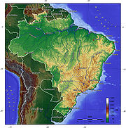
Amazon Basin
The Amazon Basin is the part of South America drained by the Amazon River and its tributaries that drains an area of about , or roughly 40 percent of South America. The basin is located in the countries of Bolivia, Brazil, Colombia, Ecuador, Guyana, Peru, and Venezuela...
and Tocantins-Araguaia account for more than half the total drainage area. The largest river system in Brazil is the Amazon, which originates in the Andes and receives tributaries from a basin that covers 45.7% of the country, principally the north and west. The main Amazon river system is the Amazonas-Solimões-Ucayali axis (the 6762 kilometres (4,202 mi)-long Ucayali is a Peruvian tributary), flowing from west to east. Through the Amazon Basin flows one-fifth of the world's fresh water. A total of 3615 kilometres (2,246 mi) of the Amazon are in Brazilian territory. Over this distance, the waters decline only about 100 metres (328.1 ft). The major tributaries on the southern side are, from west to east, the Javari, Juruá, Purus (all three of which flow into the western section of the Amazon called the Solimões
Solimões
Solimões is the name often given to early stretches of the Amazon River from the border of Brazil and Peru to its confluence with the Rio Negro.Further upstream from the border, the name of the river seems to depend on the speaker...
), Madeira
Madeira River
The Madeira River is a major waterway in South America, approximately 3,250 km miles long The Madeira is the biggest tributary of the Amazon...
, Tapajós
Tapajós
The Tapajós, a Brazilian river running through a humid and hot valley, pours into the Amazon River 500 miles above Pará and is about 1200 miles long.It rises on the lofty Brazilian plateau near Diamantino in 14 degrees 25' south latitude...
, Xingu
Xingu River
The Xingu River , also called Rio Xingu, is a 1,230-mile long, river in north Brazil; it is a southeast tributary of the Amazon River.-Description and history:...
, and Tocantins
Tocantins River
The Tocantins is a river in Brazil, the central fluvial artery of the country. In the Tupi language, its name means "toucan's beak" . It runs from south to north for about 2,640 km. It is not really a branch of the Amazon River, although usually so considered, since its waters flow into the...
. On the northern side, the largest tributaries are the Branco
Branco River
The Rio Branco is the principal affluent of the Rio Negro from the north; it is enriched by many streams from the sierras which separate Venezuela and Guyana from Brazil. Its two upper main tributaries are the Urariquira and the Takutu...
, Japurá
Japurá River
The Japurá River or Caquetá River is a river about long rising as the Caquetá River in the Andes in the Southwest of Colombia. It flows southeast into Brazil, where it is called the Japurá. The Japurá enters the Amazon River through a network of channels...
, Jari
Jari River
The Jari River, is a northern tributary of the Amazon river on the border between the states of Pará and Amapá in northeastern Brazil. It is in the most downstream regions of the Amazon Basin and borders the Guiana Highlands and the Guianas and French Guiana to the northwest.-Tributaries:*...
, and Rio Negro. The above-mentioned tributaries carry more water than the Mississippi (its discharge is less than one-tenth that of the Amazon). The Amazon and some of its tributaries, called "white" rivers, bear rich sediments and hydrobiological elements. The black-white and clear rivers—such as the Negro, Tapajós, and Xingu—have clear (greenish) or dark water with few nutrients and little sediment.
The major river system in the Northeast is the Rio São Francisco
São Francisco River
The São Francisco is a river in Brazil. With a length of , it is the longest river that runs entirely in Brazilian territory, and the fourth longest in South America and overall in Brazil...
, which flows 1609 kilometres (1,000 mi) northeast from the south-central region. Its basin covers 7.6% of the national territory. Only 277 kilometres (172 mi) of the lower river are navigable for oceangoing ships. The Paraná
Paraná River
The Paraná River is a river in south Central South America, running through Brazil, Paraguay and Argentina for some . It is second in length only to the Amazon River among South American rivers. The name Paraná is an abbreviation of the phrase "para rehe onáva", which comes from the Tupi language...
system covers 14.5% of the country. The Paraná flows south among the Río de la Plata Basin, reaching the Atlantic between Argentina and Uruguay. The headwaters of the Paraguai, the Paraná's major eastern tributary, constitute the Pantanal
Pantanal
The Pantanal is a tropical wetland and one of the world's largest wetland of any kind. Most of it lies within the Brazilian state of Mato Grosso do Sul, but it extends into Mato Grosso and portions of Bolivia and Paraguay, sprawling over an area estimated at between and...
, the largest contiguous wetlands in the world, covering as much as 230000 square kilometres (88,803.5 sq mi).
Below their descent from the highlands, many of the tributaries of the Amazon are navigable. Upstream, they generally have rapid
Rapid
A rapid is a section of a river where the river bed has a relatively steep gradient causing an increase in water velocity and turbulence. A rapid is a hydrological feature between a run and a cascade. A rapid is characterised by the river becoming shallower and having some rocks exposed above the...
s or waterfall
Waterfall
A waterfall is a place where flowing water rapidly drops in elevation as it flows over a steep region or a cliff.-Formation:Waterfalls are commonly formed when a river is young. At these times the channel is often narrow and deep. When the river courses over resistant bedrock, erosion happens...
s, and boats and barges also must face sandbars, trees, and other obstacles. Nevertheless, the Amazon is navigable by oceangoing vessels as far as 3885 kilometres (2,414 mi) upstream, reaching Iquitos
Iquitos
Iquitos is the largest city in the Peruvian rainforest, with a population of 370,962. It is the capital of Loreto Region and Maynas Province.Located on the Amazon River, it is only above sea level, although it is more than from the mouth of the Amazon at Belém on the Atlantic Ocean...
in Peru
Peru
Peru , officially the Republic of Peru , is a country in western South America. It is bordered on the north by Ecuador and Colombia, on the east by Brazil, on the southeast by Bolivia, on the south by Chile, and on the west by the Pacific Ocean....
. The Amazon river system was the principal means of access until new roads became more important hydroelectric projects are Itaipu, in Paraná, with 12,600 MW; Tucuruí, in Pará
Pará
Pará is a state in the north of Brazil. It borders the Brazilian states of Amapá, Maranhão, Tocantins, Mato Grosso, Amazonas and Roraima. To the northwest it also borders Guyana and Suriname, and to the northeast it borders the Atlantic Ocean. The capital is Belém.Pará is the most populous state...
, with 7,746 MW; and Paulo Afonso
Paulo Afonso
Paulo Afonso is a city in Bahia, Brazil. It is located at around . It was founded in 1958.The city is the seat of the Roman Catholic Diocese of Paulo Afonso.The city is served by Paulo Afonso Airport....
, in Bahia
Bahia
Bahia is one of the 26 states of Brazil, and is located in the northeastern part of the country on the Atlantic coast. It is the fourth most populous Brazilian state after São Paulo, Minas Gerais and Rio de Janeiro, and the fifth-largest in size...
, with 3,986 MW.
Natural resources
Natural resourcesNatural Resources
Natural Resources is a soul album released by Motown girl group Martha Reeves and the Vandellas in 1970 on the Gordy label. The album is significant for the Vietnam War ballad "I Should Be Proud" and the slow jam, "Love Guess Who"...
include: bauxite
Bauxite
Bauxite is an aluminium ore and is the main source of aluminium. This form of rock consists mostly of the minerals gibbsite Al3, boehmite γ-AlO, and diaspore α-AlO, in a mixture with the two iron oxides goethite and hematite, the clay mineral kaolinite, and small amounts of anatase TiO2...
, gold
Gold
Gold is a chemical element with the symbol Au and an atomic number of 79. Gold is a dense, soft, shiny, malleable and ductile metal. Pure gold has a bright yellow color and luster traditionally considered attractive, which it maintains without oxidizing in air or water. Chemically, gold is a...
, iron
Iron
Iron is a chemical element with the symbol Fe and atomic number 26. It is a metal in the first transition series. It is the most common element forming the planet Earth as a whole, forming much of Earth's outer and inner core. It is the fourth most common element in the Earth's crust...
ore
Ore
An ore is a type of rock that contains minerals with important elements including metals. The ores are extracted through mining; these are then refined to extract the valuable element....
, manganese
Manganese
Manganese is a chemical element, designated by the symbol Mn. It has the atomic number 25. It is found as a free element in nature , and in many minerals...
, nickel
Nickel
Nickel is a chemical element with the chemical symbol Ni and atomic number 28. It is a silvery-white lustrous metal with a slight golden tinge. Nickel belongs to the transition metals and is hard and ductile...
, phosphates, platinum
Platinum
Platinum is a chemical element with the chemical symbol Pt and an atomic number of 78. Its name is derived from the Spanish term platina del Pinto, which is literally translated into "little silver of the Pinto River." It is a dense, malleable, ductile, precious, gray-white transition metal...
, tin
Tin
Tin is a chemical element with the symbol Sn and atomic number 50. It is a main group metal in group 14 of the periodic table. Tin shows chemical similarity to both neighboring group 14 elements, germanium and lead and has two possible oxidation states, +2 and the slightly more stable +4...
, uranium
Uranium
Uranium is a silvery-white metallic chemical element in the actinide series of the periodic table, with atomic number 92. It is assigned the chemical symbol U. A uranium atom has 92 protons and 92 electrons, of which 6 are valence electrons...
, petroleum
Petroleum
Petroleum or crude oil is a naturally occurring, flammable liquid consisting of a complex mixture of hydrocarbons of various molecular weights and other liquid organic compounds, that are found in geologic formations beneath the Earth's surface. Petroleum is recovered mostly through oil drilling...
, hydropower
Hydropower
Hydropower, hydraulic power, hydrokinetic power or water power is power that is derived from the force or energy of falling water, which may be harnessed for useful purposes. Since ancient times, hydropower has been used for irrigation and the operation of various mechanical devices, such as...
and timber
Timber
Timber may refer to:* Timber, a term common in the United Kingdom and Australia for wood materials * Timber, Oregon, an unincorporated community in the U.S...
.
Rivers and lakes
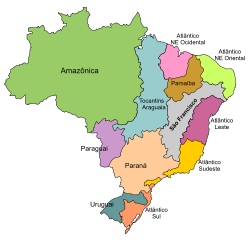
- 7 Hydrographic Regions named after their dominant rivers:
- AmazonasAmazon BasinThe Amazon Basin is the part of South America drained by the Amazon River and its tributaries that drains an area of about , or roughly 40 percent of South America. The basin is located in the countries of Bolivia, Brazil, Colombia, Ecuador, Guyana, Peru, and Venezuela...
- ParaguaiParaguay RiverThe Paraguay River is a major river in south central South America, running through Brazil, Bolivia, Paraguay, and Argentina...
- ParanáParaná RiverThe Paraná River is a river in south Central South America, running through Brazil, Paraguay and Argentina for some . It is second in length only to the Amazon River among South American rivers. The name Paraná is an abbreviation of the phrase "para rehe onáva", which comes from the Tupi language...
- ParnaíbaParnaiba RiverThe Parnaíba River is a river in Brazil, which forms the border between the states of Maranhão and Piauí. The Parnaíba River rises in the Chapada das Mangabeiras range, and flows northeastward for 1,056 miles to empty into the Atlantic Ocean. The middle and upper regions of this river are...
- São FranciscoSão Francisco RiverThe São Francisco is a river in Brazil. With a length of , it is the longest river that runs entirely in Brazilian territory, and the fourth longest in South America and overall in Brazil...
- TocantinsTocantins RiverThe Tocantins is a river in Brazil, the central fluvial artery of the country. In the Tupi language, its name means "toucan's beak" . It runs from south to north for about 2,640 km. It is not really a branch of the Amazon River, although usually so considered, since its waters flow into the...
- UruguaiUruguay RiverThe Uruguay River is a river in South America. It flows from north to south and makes boundary with Brazil, Argentina, and Uruguay, separating some of the Argentine provinces of the Mesopotamia from the other two countries...
- Amazonas
- 5 coastal Hydrographic Regions based on regional groupings of minor river basins (listed from north to south):
- Atlântico Nordeste Ocidental (Western North-east Atlantic)
- Atlântico Nordeste Oriental (Eastern North-east Atlantic)
- Atlântico Leste (Eastern Atlantic)
- Atlântico Sudeste (South-east Atlantic)
- Atlântico Sul (South Atlantic)
The Amazon River
Amazon River
The Amazon of South America is the second longest river in the world and by far the largest by waterflow with an average discharge greater than the next seven largest rivers combined...
is the widest and second longest river (behind the Nile) in the world. This huge river drains the greater part of the world's rainforests. Another major river, the Paraná, has its source in Brazil. It forms the border of Paraguay and Argentina, then winds its way through Argentina and into the Atlantic Ocean, along the southern coast of Uruguay. The HBV
HBV hydrology model
The HBV hydrology model, or Hydrologiska Byråns Vattenbalansavdelning model, is a computer simulation used to analyze river discharge and water pollution...
hydrology transport model has been used to analyze certain pollutant transport in Brazil's river systems.
The Amazon is full of eroded soil.
Soils and vegetation

Agriculture
Agriculture is the cultivation of animals, plants, fungi and other life forms for food, fiber, and other products used to sustain life. Agriculture was the key implement in the rise of sedentary human civilization, whereby farming of domesticated species created food surpluses that nurtured the...
productivity has been generally disappointing. High initial fertility after clearing and burning usually is depleted rapidly, and acidity and aluminum content are often high. Together with the rapid growth of weed
Weed
A weed in a general sense is a plant that is considered by the user of the term to be a nuisance, and normally applied to unwanted plants in human-controlled settings, especially farm fields and gardens, but also lawns, parks, woods, and other areas. More specifically, the term is often used to...
s and pests in cultivated areas, as a result of high temperatures and humidity, this loss of fertility explains the westward movement of the agricultural frontier and slash-and-burn agriculture; it takes less investment in work or money to clear new land than to continue cultivating the same land. Burning also is used traditionally to remove tall, dry, and nutrient-poor grass from pasture at the end of the dry season. Until mechanization and the use of chemical and genetic inputs increased during the agricultural intensification period of the 1970s and 1980s, coffee
Coffee
Coffee is a brewed beverage with a dark,init brooo acidic flavor prepared from the roasted seeds of the coffee plant, colloquially called coffee beans. The beans are found in coffee cherries, which grow on trees cultivated in over 70 countries, primarily in equatorial Latin America, Southeast Asia,...
planting and farming in general moved constantly onward to new lands in the west and north. This pattern of horizontal or extensive expansion maintained low levels of technology and productivity and placed emphasis on quantity rather than quality of agricultural production.
The largest areas of fertile soils, called terra roxa (red earth), are found in the states of Paraná
Paraná (state)
Paraná is one of the states of Brazil, located in the South of the country, bordered on the north by São Paulo state, on the east by the Atlantic Ocean, on the south by Santa Catarina state and the Misiones Province of Argentina, and on the west by Mato Grosso do Sul and the republic of Paraguay,...
and São Paulo
São Paulo
São Paulo is the largest city in Brazil, the largest city in the southern hemisphere and South America, and the world's seventh largest city by population. The metropolis is anchor to the São Paulo metropolitan area, ranked as the second-most populous metropolitan area in the Americas and among...
. The least fertile areas are in the Amazon, where the dense rain forest is. Soils in the Northeast
Northeast Region, Brazil
The Northeast Region of Brazil is composed of the following states: Maranhão, Piauí, Ceará, Rio Grande do Norte, Paraíba, Pernambuco, Alagoas, Sergipe and Bahia, and it represents 18.26% of the Brazilian territory....
are often fertile, but they lack water, unless they are irrigated
Irrigation
Irrigation may be defined as the science of artificial application of water to the land or soil. It is used to assist in the growing of agricultural crops, maintenance of landscapes, and revegetation of disturbed soils in dry areas and during periods of inadequate rainfall...
artificially.
In the 1980s, investments made possible the use of irrigation, especially in the Northeast Region and in Rio Grande do Sul
Rio Grande do Sul
Rio Grande do Sul is the southernmost state in Brazil, and the state with the fifth highest Human Development Index in the country. In this state is located the southernmost city in the country, Chuí, on the border with Uruguay. In the region of Bento Gonçalves and Caxias do Sul, the largest wine...
State, which had shifted from grazing to soy and rice
Rice
Rice is the seed of the monocot plants Oryza sativa or Oryza glaberrima . As a cereal grain, it is the most important staple food for a large part of the world's human population, especially in East Asia, Southeast Asia, South Asia, the Middle East, and the West Indies...
production in the 1970s. Savanna
Savanna
A savanna, or savannah, is a grassland ecosystem characterized by the trees being sufficiently small or widely spaced so that the canopy does not close. The open canopy allows sufficient light to reach the ground to support an unbroken herbaceous layer consisting primarily of C4 grasses.Some...
soils also were made usable for soybean farming through acidity correction, fertilization, plant breeding
Plant breeding
Plant breeding is the art and science of changing the genetics of plants in order to produce desired characteristics. Plant breeding can be accomplished through many different techniques ranging from simply selecting plants with desirable characteristics for propagation, to more complex molecular...
, and in some cases spray irrigation. As agriculture underwent modernization in the 1970s and 1980s, soil fertility became less important for agricultural production than factors related to capital investment, such as infrastructure, mechanization, use of chemical inputs, breeding, and proximity to markets. Consequently, the vigor of frontier expansion weakened.
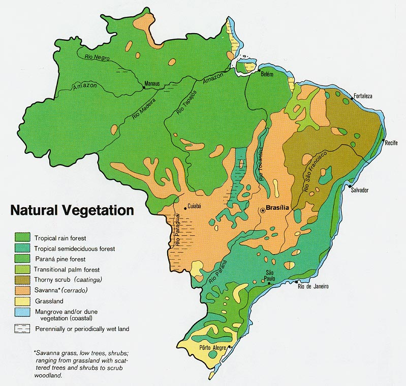
The variety of climates, soils, and drainage conditions in Brazil is reflected in the range of its vegetation types. The Amazon Basin and the areas of heavy rainfall along the Atlantic coast have tropical rain forest composed of broadleaf evergreen trees. The rain forest may contain as many as 3,000 species
Species
In biology, a species is one of the basic units of biological classification and a taxonomic rank. A species is often defined as a group of organisms capable of interbreeding and producing fertile offspring. While in many cases this definition is adequate, more precise or differing measures are...
of flora
Flora
Flora is the plant life occurring in a particular region or time, generally the naturally occurring or indigenous—native plant life. The corresponding term for animals is fauna.-Etymology:...
and fauna
Fauna
Fauna or faunæ is all of the animal life of any particular region or time. The corresponding term for plants is flora.Zoologists and paleontologists use fauna to refer to a typical collection of animals found in a specific time or place, e.g. the "Sonoran Desert fauna" or the "Burgess shale fauna"...
within a 2.6 square kilometres (1 sq mi) area. The Atlantic Forest is reputed to have even greater biological diversity than the Amazon rain forest, which, despite apparent homogeneity, contains many types of vegetation, from high canopy forest to bamboo groves.
In the semiarid Northeast, caatinga
Caatinga
Caatinga is a type of vegetation, and an ecoregion characterized by this vegetation in the northeastern part of Brazil. The name "Caatinga" is a Tupi word meaning "white forest" or "white vegetation"...
, a dry, thick, thorny vegetation, predominates. Most of central Brazil is covered with a woodland savanna, known as the cerrado
Cerrado
The Cerrado, is a vast tropical savanna ecoregion of Brazil, particularly in the states of Gioas and Minas Gerais...
(sparse scrub trees and drought-resistant grasses), which became an area of agricultural development after the mid-1970s. In the South
Southern Region, Brazil
The South Region of Brazil is one of the five regions of Brazil. It includes the states of Paraná, Santa Catarina and Rio Grande do Sul and covers 576,409.6 km ², being the smallest portion of the country...
(Sul), needle-leaved pinewood
Pinewood
Pinewood may refer to:* Pine, a species of tree* Pinewood Studios, a major British film studio in Buckinghamshire-Places:in England* Pinewood, Suffolkin the United States* Pinewood, Florida* Pinewood, Minnesota...
s (Paraná pine or araucaria
Araucaria
Araucaria is a genus of evergreen coniferous trees in the family Araucariaceae. There are 19 extant species in the genus, with a highly disjunct distribution in New Caledonia , Norfolk Island, eastern Australia, New Guinea, Argentina, Chile, and southern Brazil.-Description:Araucaria are mainly...
) cover the highlands; grassland similar to the Argentine pampa
Pampa
The Pampas are the fertile South American lowlands, covering more than , that include the Argentine provinces of Buenos Aires, La Pampa, Santa Fe, Entre Ríos and Córdoba, most of Uruguay, and the southernmost Brazilian State, Rio Grande do Sul...
covers the sea-level plains. The Mato Grosso swampland
Swampland
In physics, the term swampland is used in contrast to the term "landscape," to indicate physical theories or aspects of such theories which could be true if gravity wasn't an issue, but which are not compatible with string theory...
s (Pantanal
Pantanal
The Pantanal is a tropical wetland and one of the world's largest wetland of any kind. Most of it lies within the Brazilian state of Mato Grosso do Sul, but it extends into Mato Grosso and portions of Bolivia and Paraguay, sprawling over an area estimated at between and...
Mato-grossense) is a Florida
Florida
Florida is a state in the southeastern United States, located on the nation's Atlantic and Gulf coasts. It is bordered to the west by the Gulf of Mexico, to the north by Alabama and Georgia and to the east by the Atlantic Ocean. With a population of 18,801,310 as measured by the 2010 census, it...
-sized plain in the western portion of the Center-West (Centro-Oeste). It is covered with tall grass
Grass
Grasses, or more technically graminoids, are monocotyledonous, usually herbaceous plants with narrow leaves growing from the base. They include the "true grasses", of the Poaceae family, as well as the sedges and the rushes . The true grasses include cereals, bamboo and the grasses of lawns ...
es, bush
Woody plant
A woody plant is a plant that uses wood as its structural tissue. These are typically perennial plants whose stems and larger roots are reinforced with wood produced adjacent to the vascular tissues. The main stem, larger branches, and roots of these plants are usually covered by a layer of...
es, and widely dispersed trees similar to those of the cerrado and is partly submerged during the rainy season.
Brazil, which is named after reddish dyewood (pau brasil
Pau Brasil
Pau Brasil is a town and municipality in the state of Bahia in the North-East region of Brazil.-References:...
), has long been famous for the wealth of its tropical forests. These are not, however, as important to world markets as those of Asia and Africa, which started to reach depletion only in the 1980s. By 1996 more than 90% of the original Atlantic forest had been cleared, primarily for agriculture, with little use made of the wood, except for araucaria pine in Paraná.
The inverse situation existed with regard to clearing for wood in the Amazon rain forest, of which about 15% had been cleared by 1994, and part of the remainder had been disturbed by selective logging. Because the Amazon forest is highly heterogeneous, with hundreds of woody species per hectare
Hectare
The hectare is a metric unit of area defined as 10,000 square metres , and primarily used in the measurement of land. In 1795, when the metric system was introduced, the are was defined as being 100 square metres and the hectare was thus 100 ares or 1/100 km2...
, there is considerable distance between individual trees of economic value, such as mahogany
Mahogany
The name mahogany is used when referring to numerous varieties of dark-colored hardwood. It is a native American word originally used for the wood of the species Swietenia mahagoni, known as West Indian or Cuban mahogany....
and cerejeira. Therefore, this type of forest is not normally cleared for timber extraction but logged through high-grading, or selection of the most valuable trees. Because of vines, felling, and transportation, their removal causes destruction of many other trees, and the litter and new growth create a risk of forest fires, which are otherwise rare in rain forests. In favorable locations, such as Paragominas, in the northeastern part of Pará
Pará
Pará is a state in the north of Brazil. It borders the Brazilian states of Amapá, Maranhão, Tocantins, Mato Grosso, Amazonas and Roraima. To the northwest it also borders Guyana and Suriname, and to the northeast it borders the Atlantic Ocean. The capital is Belém.Pará is the most populous state...
State, a new pattern of timber extraction has emerged: diversification and the production of plywood
Plywood
Plywood is a type of manufactured timber made from thin sheets of wood veneer. It is one of the most widely used wood products. It is flexible, inexpensive, workable, re-usable, and can usually be locally manufactured...
have led to the economic use of more than 100 tree species.
Starting in the late 1980s, rapid deforestation and extensive burning in Brazil received considerable international and national attention. Satellite images have helped document and quantify deforestation as well as fires, but their use also has generated considerable controversy because of problems of defining original vegetation, cloud cover, and dealing with secondary growth and because fires, as mentioned above, may occur in old pasture rather than signifying new clearing. Public policies intended to promote sustainable management of timber extraction, as well as sustainable use of nontimber forest products (such as rubber, Brazil nut
Brazil Nut
The Brazil nut is a South American tree in the family Lecythidaceae, and also the name of the tree's commercially harvested edible seed.- Order :...
s, fruit
Fruit
In broad terms, a fruit is a structure of a plant that contains its seeds.The term has different meanings dependent on context. In non-technical usage, such as food preparation, fruit normally means the fleshy seed-associated structures of certain plants that are sweet and edible in the raw state,...
s, seed
Seed
A seed is a small embryonic plant enclosed in a covering called the seed coat, usually with some stored food. It is the product of the ripened ovule of gymnosperm and angiosperm plants which occurs after fertilization and some growth within the mother plant...
s, oils, and vine
Vine
A vine in the narrowest sense is the grapevine , but more generally it can refer to any plant with a growth habit of trailing or scandent, that is to say climbing, stems or runners...
s), were being discussed intensely in the mid-1990s. However, implementing the principles of sustainable development, without irreversible damage to the environment, proved to be more challenging than establishing international agreements about them.
Climate
Although 90% of the country is within the tropical zone, the climate of Brazil varies considerably from the mostly tropical North (the equatorEquator
An equator is the intersection of a sphere's surface with the plane perpendicular to the sphere's axis of rotation and containing the sphere's center of mass....
traverses the mouth of the Amazon) to temperate zones below the Tropic of Capricorn
Tropic of Capricorn
The Tropic of Capricorn, or Southern tropic, marks the most southerly latitude on the Earth at which the Sun can be directly overhead. This event occurs at the December solstice, when the southern hemisphere is tilted towards the Sun to its maximum extent.Tropic of Capricorn is one of the five...
(23°27' S latitude), which crosses the country at the latitude of the city of São Paulo. Brazil has five climatic regions: equatorial, tropical, semiarid, highland tropical, and subtropical.
Temperatures along the equator are high, averaging above 25 °C (77 °F), but not reaching the summer extremes of up to 40 °C (104 °F) in the temperate zones. There is little seasonal variation near the equator, although at times it can get cool enough for wearing a jacket, especially in the rain. At the country's other extreme, there are frosts south of the Tropic of Capricorn during the winter (June–August), and there is snow in the mountainous areas, such as Paraná
Paraná (state)
Paraná is one of the states of Brazil, located in the South of the country, bordered on the north by São Paulo state, on the east by the Atlantic Ocean, on the south by Santa Catarina state and the Misiones Province of Argentina, and on the west by Mato Grosso do Sul and the republic of Paraguay,...
, Rio Grande do Sul
Rio Grande do Sul
Rio Grande do Sul is the southernmost state in Brazil, and the state with the fifth highest Human Development Index in the country. In this state is located the southernmost city in the country, Chuí, on the border with Uruguay. In the region of Bento Gonçalves and Caxias do Sul, the largest wine...
and Santa Catarina
Santa Catarina (state)
Santa Catarina is a state in southern Brazil with one of the highest standards of living in Latin America. Its capital is Florianópolis, which mostly lies on the Santa Catarina Island. Neighbouring states are Rio Grande do Sul to the south and Paraná to the north. It is bounded on the east by...
. Temperatures in the cities of São Paulo, Belo Horizonte
Belo Horizonte
Belo Horizonte is the capital of and largest city in the state of Minas Gerais, located in the southeastern region of Brazil. It is the third largest metropolitan area in the country...
, and Brasília
Brasília
Brasília is the capital city of Brazil. The name is commonly spelled Brasilia in English. The city and its District are located in the Central-West region of the country, along a plateau known as Planalto Central. It has a population of about 2,557,000 as of the 2008 IBGE estimate, making it the...
are moderate (usually between 15 and 30 °C (59 and 86 F)), despite their relatively low latitude, because of their elevation of approximately 1000 metres (3,281 ft). Rio de Janeiro, Recife, and Salvador on the coast have warm climates, with average temperatures ranging from 23 to 27 °C (73.4 to 80.6 F), but enjoy constant trade winds. The southern cities of Porto Alegre
Porto Alegre
Porto Alegre is the tenth most populous municipality in Brazil, with 1,409,939 inhabitants, and the centre of Brazil's fourth largest metropolitan area . It is also the capital city of the southernmost Brazilian state of Rio Grande do Sul. The city is the southernmost capital city of a Brazilian...
and Curitiba
Curitiba
Curitiba is the capital of the Brazilian state of Paraná. It is the largest city with the biggest economy of both Paraná and southern Brazil. The population of Curitiba numbers approximately 1.75 million people and the latest GDP figures for the city surpass US$61 billion according to...
have a subtropical climate similar to that in parts of the United States and Europe, and temperatures can fall below freezing in winter.
Precipitation levels vary widely. Most of Brazil has moderate rainfall of between 1000 and 1500 mm (39.4 and 59.1 in) a year, with most of the rain falling in the summer (between December and April) south of the Equator. The Amazon region is notoriously humid, with rainfall generally more than 2000 millimetres (78.7 in) per year and reaching as high as 3000 millimetres (118.1 in) in parts of the western Amazon and near Belém. It is less widely known that, despite high annual precipitation, the Amazon rain forest has a three- to five-month dry season, the timing of which varies according to location north or south of the equator.
High and relatively regular levels of precipitation in the Amazon contrast sharply with the dryness of the semiarid Northeast, where rainfall is scarce and there are severe droughts in cycles averaging seven years. The Northeast
Northeast Region, Brazil
The Northeast Region of Brazil is composed of the following states: Maranhão, Piauí, Ceará, Rio Grande do Norte, Paraíba, Pernambuco, Alagoas, Sergipe and Bahia, and it represents 18.26% of the Brazilian territory....
is the driest part of the country. The region also constitutes the hottest part of Brazil, where during the dry season between May and November, temperatures of more than 38 °C (100 °F) have been recorded. However, the sertão
Sertão
In Portuguese, the word sertão first referred to the vast hinterlands of Asia that Lusitanian explorers encountered. In Brazil, the geographical term referred to backlands away from the Atlantic coastal regions where the Portuguese first settled in South America in the early sixteenth century...
, a region of semidesert vegetation
Desert
A desert is a landscape or region that receives an extremely low amount of precipitation, less than enough to support growth of most plants. Most deserts have an average annual precipitation of less than...
used primarily for low-density ranching, turns green when there is rain. Most of the Center-West has 1500 to 2000 mm (59.1 to 78.7 in) of rain per year, with a pronounced dry season in the middle of the year, while the South and most of the year without a distinct dry season.
Geographic regions


Brazilian Federal District
The Federal District is set apart for Brasília, the capital of Brazil. Located in a region called Planalto Central, or Central Plateau, the Federal District is divided in 29 administrative regions. Brasilia - place where the three branches of the Federal Government are located - is the main...
(Distrito Federal) are divided conventionally into five regions: North
North Region, Brazil
The North Region of Brazil is the largest Region of Brazil, corresponding to 45.27% of the national territory. It is the least inhabited of the country, and contributes with a minor percentage in the national GDP and population...
(Norte), Northeast (Nordeste), Southeast
Southeast Region, Brazil
The Southeast Region of Brazil is composed by the states of Espírito Santo, Minas Gerais, Rio de Janeiro and São Paulo. It is the richest region of the country, responsible for approximately 60% of the Brazilian GDP. São Paulo, Rio de Janeiro and Minas Gerais are three richest states of Brazil,...
(Sudeste), South
Southern Region, Brazil
The South Region of Brazil is one of the five regions of Brazil. It includes the states of Paraná, Santa Catarina and Rio Grande do Sul and covers 576,409.6 km ², being the smallest portion of the country...
(Sul), and Center-West
Center-West Region, Brazil
The Central-West Region of Brazil is composed of the states of Goiás, Mato Grosso and Mato Grosso do Sul; along with Distrito Federal , where Brazil's national capital, Brasília, is situated...
(Centro-Oeste) - see fig. 4. In 1996 there were 5,581 municipalities (municípios), which have municipal governments. Many municipalities, which are comparable to United States counties, are in turn divided into district
District
Districts are a type of administrative division, in some countries managed by a local government. They vary greatly in size, spanning entire regions or counties, several municipalities, or subdivisions of municipalities.-Austria:...
s (distritos), which do not have political or administrative autonomy
Autonomy
Autonomy is a concept found in moral, political and bioethical philosophy. Within these contexts, it is the capacity of a rational individual to make an informed, un-coerced decision...
. In 1995 there were 9,274 districts. All municipal and district seats, regardless of size, are considered officially to be urban. For purely statistical purposes, the municipalities were grouped in 1990 into 559 micro-regions, which in turn constituted 136 meso-regions. This grouping modified the previous micro-regional division established in 1968, a division that was used to present census data for 1970, 1975, 1980, and 1985.
Each of the five major regions has a distinct ecosystem
Ecosystem
An ecosystem is a biological environment consisting of all the organisms living in a particular area, as well as all the nonliving , physical components of the environment with which the organisms interact, such as air, soil, water and sunlight....
. Administrative boundaries do not necessarily coincide with ecological boundaries, however. In addition to differences in physical environment, patterns of economic activity and population settlement vary widely among the regions. The principal ecological characteristics of each of the five major regions, as well as their principal socioeconomic and demographic features, are summarized below.
Centerwest
The Center-West consists of the states of Goiás, Mato GrossoMato Grosso
Mato Grosso is one of the states of Brazil, the third largest in area, located in the western part of the country.Neighboring states are Rondônia, Amazonas, Pará, Tocantins, Goiás and Mato Grosso do Sul. It also borders Bolivia to the southwest...
, and Mato Grosso do Sul
Mato Grosso do Sul
Mato Grosso do Sul is one of the states of Brazil.Neighboring Brazilian states are Mato Grosso, Goiás, Minas Gerais, São Paulo and Paraná. It also borders the countries of Paraguay and Bolivia to the west. The economy of the state is largely based on agriculture and cattle-raising...
(separated from Mato Grosso in 1979), as well as the Federal District
Federal district
Federal districts are a type of administrative division of a federation, under the direct control of a federal government. They exist in various countries and states all over the world.-United States:...
, site of Brasília
Brasília
Brasília is the capital city of Brazil. The name is commonly spelled Brasilia in English. The city and its District are located in the Central-West region of the country, along a plateau known as Planalto Central. It has a population of about 2,557,000 as of the 2008 IBGE estimate, making it the...
, the national capital. Until 1988 Goiás State included the area that then became the state of Tocantins in the North.
The Center-West has 1612077 square kilometres (622,426 sq mi) and covers 18.9% of the national territory. Its main biome is the cerrado
Cerrado
The Cerrado, is a vast tropical savanna ecoregion of Brazil, particularly in the states of Gioas and Minas Gerais...
, the tropical savanna in which natural grassland is partly covered with twisted shrubs and small trees. The cerrado was used for low-density cattle-raising in the past but is now also used for soybean production. There are gallery forest
Gallery forest
Gallery forests are evergreen forests that form as corridors along rivers or wetlands and project into landscapes that are otherwise only sparsely treed such as savannas, grasslands or deserts....
s along the rivers and streams and some larger areas of forest, most of which have been cleared for farming and livestock
Livestock
Livestock refers to one or more domesticated animals raised in an agricultural setting to produce commodities such as food, fiber and labor. The term "livestock" as used in this article does not include poultry or farmed fish; however the inclusion of these, especially poultry, within the meaning...
. In the north, the cerrado blends into tropical forest. It also includes the Pantanal
Pantanal
The Pantanal is a tropical wetland and one of the world's largest wetland of any kind. Most of it lies within the Brazilian state of Mato Grosso do Sul, but it extends into Mato Grosso and portions of Bolivia and Paraguay, sprawling over an area estimated at between and...
wetland
Wetland
A wetland is an area of land whose soil is saturated with water either permanently or seasonally. Wetlands are categorised by their characteristic vegetation, which is adapted to these unique soil conditions....
s in the west, known for their wildlife, especially aquatic birds and cayman
Cayman
Cayman may refer to* Cayman Islands, an overseas territory of the United Kingdom;* Grand Cayman, Cayman Brac, or Little Cayman, three islands that are part of the Cayman Islands;* Porsche Cayman, a sports car produced by Porsche;...
s. In the early 1980s, 33.6% of the region had been altered by anthropic activities, with a low of 9.3% in Mato Grosso and a high of 72.9% in Goiás (not including Tocantins). In 1996 the Center-West region had 10.2 million inhabitants, or 6% of Brazil's total population. The average density is low, with concentrations in and around the cities of Brasília
Brasília
Brasília is the capital city of Brazil. The name is commonly spelled Brasilia in English. The city and its District are located in the Central-West region of the country, along a plateau known as Planalto Central. It has a population of about 2,557,000 as of the 2008 IBGE estimate, making it the...
, Goiânia
Goiânia
-Climate:The city has a tropical wet and dry climate with an average temperature of . There's a wet season, from October to April, and a dry one, from May to September. Annual rainfall is around 1,520 mm....
, Campo Grande
Campo Grande
-Climate:Campo Grande has a highland tropical climate, semi-humid, hot, and notably seasonal, with a dry winter season from May through September or October. Under the Koppen climate classification Campo Grande features a tropical wet and dry climate, albeit a noticeably cooler version of the...
, and Cuiabá
Cuiabá
Under the Koppen climate classification, Cuiaba features a tropical wet and dry climate. Cuiabá is famous for its searing heat, although temperatures in winter can arrive sporadically at 10 degrees, indeed atypical, caused by cold fronts coming from the south, and that may only last one or two...
. Living standards are below the national average. In 1994 they were highest in the Federal District, with per capita income of US$7,089 (the highest in the nation), and lowest in Mato Grosso, with US$2,268.
Northeast
The nine states that make up the Northeast are AlagoasAlagoas
Alagoas is one of the 27 federative units of Brazil and is situated in the eastern part of the Northeast Region. It borders: Pernambuco ; Sergipe ; Bahia ; and the Atlantic Ocean . It occupies an area of 27,767 km², being slightly larger than Haiti...
, Bahia
Bahia
Bahia is one of the 26 states of Brazil, and is located in the northeastern part of the country on the Atlantic coast. It is the fourth most populous Brazilian state after São Paulo, Minas Gerais and Rio de Janeiro, and the fifth-largest in size...
, Ceará
Ceará
Ceará is one of the 27 states of Brazil, located in the northeastern part of the country, on the Atlantic coast. It is currently the 8th largest Brazilian State by population and the 17th by area. It is also one of the main touristic destinations in Brazil. The state capital is the city of...
, Maranhão
Maranhão
Maranhão is a northeastern state of Brazil. To the north lies the Atlantic Ocean. Maranhão is neighbored by the states of Piauí, Tocantins and Pará. The people of Maranhão have a distinctive accent...
, Paraíba
Paraíba
Paraíba Paraíba Paraíba (Tupi: pa'ra a'íba: "bad to navigation"; Brazilian Portuguese pronunciation: is a state of Brazil. It is located in the Brazilian Northeast, and is bordered by Rio Grande do Norte to the north, Ceará to the west, Pernambuco to the south and the Atlantic Ocean to the east...
, Pernambuco
Pernambuco
Pernambuco is a state of Brazil, located in the Northeast region of the country. To the north are the states of Paraíba and Ceará, to the west is Piauí, to the south are Alagoas and Bahia, and to the east is the Atlantic Ocean. There are about of beaches, some of the most beautiful in the...
, Piauí
Piauí
Piauí is one of the states of Brazil, located in the northeastern part of the country.Piauí has the shortest coastline of any of the non-landlocked Brazilian states at 66 km , and the capital, Teresina, is the only state capital in the north east to be located inland...
, Rio Grande do Norte, and Sergipe
Sergipe
Sergipe , is the smallest state of the Brazilian Federation, located on the northeastern Atlantic coast of the country. It borders on two other states, Bahia to the south and west and Alagoas to the north, and to the east is the Atlantic Ocean...
. The Fernando de Noronha
Fernando de Noronha
Fernando de Noronha is an archipelago of 21 islands and islets in the Atlantic Ocean, offshore from the Brazilian coast. The main island has an area of and had a population of 3,012 in the year 2010...
archipelago (formerly the federal territory of Fernando de Noronha
Fernando de Noronha
Fernando de Noronha is an archipelago of 21 islands and islets in the Atlantic Ocean, offshore from the Brazilian coast. The main island has an area of and had a population of 3,012 in the year 2010...
, now part of Pernambuco
Pernambuco
Pernambuco is a state of Brazil, located in the Northeast region of the country. To the north are the states of Paraíba and Ceará, to the west is Piauí, to the south are Alagoas and Bahia, and to the east is the Atlantic Ocean. There are about of beaches, some of the most beautiful in the...
state) is also included in the Northeast.
The Northeast, with 1561178 square kilometres (602,774 sq mi), covers 18.3% of the national terrest concentration of rural population, and its living standards are the lowest in Brazil. In 1994 Piauí had the lowest per capita income in the region and the country, only US$835, while Sergipe had the highest average income in the region, with US$1,958.
North
The equatorial North, also known as the Amazon or Amazônia, includes, from west to east, the states of RondôniaRondônia
Rondônia is a state in Brazil, located in the north-western part of the country. To the west is a short border with the state of Acre, to the north is the state of Amazonas, in the east is Mato Grosso, and in the south is Bolivia. Its capital is Porto Velho. The state was named after Candido Rondon...
, Acre, Amazonas, Roraima
Roraima
Roraima is the northernmost and least populated state of Brazil, located in the Amazon region. It borders the states of Amazonas and Pará, as well as the nations of Venezuela and Guyana. The population is 400,000 and the capital is Boa Vista...
, Pará
Pará
Pará is a state in the north of Brazil. It borders the Brazilian states of Amapá, Maranhão, Tocantins, Mato Grosso, Amazonas and Roraima. To the northwest it also borders Guyana and Suriname, and to the northeast it borders the Atlantic Ocean. The capital is Belém.Pará is the most populous state...
, Amapá
Amapá
Amapá is one of the states of Brazil, located in the extreme north, bordering French Guiana and Suriname to the north. To the east is the Atlantic Ocean, and to the south and west is the Brazilian state of Pará. Perhaps one of the main features of the state is the River Oiapoque, as it was once...
, and, as of 1988, Tocantins
Tocantins (state)
Tocantins is one of the states of Brazil. . The state was formed in 1988 out of the northern part of Goiás, and construction began on the capital, Palmas, in 1989, in contrast to most of the other cities in the state which date back to the Portuguese colonial period...
(created from the northern part of Goiás State, which is situated in the Center-West). Rondônia, previously a federal territory, became a state in 1986. The former federal territories of Roraima and Amapá were raised to statehood in 1988.
With 3869638 square kilometres (1,494,076 sq mi), the North is the country's largest region, covering 45.3% of the national territory. The region's principal biome
Biome
Biomes are climatically and geographically defined as similar climatic conditions on the Earth, such as communities of plants, animals, and soil organisms, and are often referred to as ecosystems. Some parts of the earth have more or less the same kind of abiotic and biotic factors spread over a...
is the humid tropical forest, also known as the rain forest, home to some of the planet's richest biological diversity. The North has served as a source of forest products ranging from "backlands drugs" (such as sarsaparilla
Sarsaparilla
is a perennial trailing vine with prickly stems that is native to Central America. Common names include Sarsaparilla , Honduran Sarsaparilla, and Jamaican Sarsaparilla...
, cocoa, cinnamon
Cinnamon
Cinnamon is a spice obtained from the inner bark of several trees from the genus Cinnamomum that is used in both sweet and savoury foods...
, and turtle butter
Turtle
Turtles are reptiles of the order Testudines , characterised by a special bony or cartilaginous shell developed from their ribs that acts as a shield...
) in the colonial period to rubber and Brazil nut
Brazil Nut
The Brazil nut is a South American tree in the family Lecythidaceae, and also the name of the tree's commercially harvested edible seed.- Order :...
s in more recent times. In the mid-twentieth century, nonforest products from mining
Mining
Mining is the extraction of valuable minerals or other geological materials from the earth, from an ore body, vein or seam. The term also includes the removal of soil. Materials recovered by mining include base metals, precious metals, iron, uranium, coal, diamonds, limestone, oil shale, rock...
, farming, and livestock-raising became more important, and in the 1980s the lumber industry boomed. In 1990, 6.6% of the region's territory was considered altered by anthropic (man-made) action, with state levels varying from 0.9% in Amapá to 14.0% in Rondônia.
In 1996 the North had 11.1 million inhabitants, only 7% of the national total. However, its share of Brazil's total had grown rapidly in the 1970s and early 1980s as a result of interregional migration, as well as high rates of natural increase. The largest population concentrations are in eastern Pará State and in Rondônia. The major cities are Belém
Belém
Belém is a Brazilian city, the capital and largest city of state of Pará, in the country's north region. It is the entrance gate to the Amazon with a busy port, airport and bus/coach station...
and Santarém
Santarém
-In Portugal:* Santarém District, a district in Portugal* Santarém Municipality, a municipality in that district* Santarém, Portugal the seat of the above district* Roman Catholic Diocese of Santarém, Portugal-Other:* Santarém cheese, a Portuguese goat cheese...
in Pará, and Manaus
Manaus
Manaus is a city in Brazil, the capital of the state of Amazonas. It is situated at the confluence of the Negro and Solimões rivers. It is the most populous city of Amazonas, according to the statistics of Brazilian Institute of Geography and Statistics, and is a popular ecotourist destination....
in Amazonas. Living standards are below the national average. The highest per capita income
Per capita income
Per capita income or income per person is a measure of mean income within an economic aggregate, such as a country or city. It is calculated by taking a measure of all sources of income in the aggregate and dividing it by the total population...
, US$2,888, in the region in 1994, was in Amazonas, while the lowest, US$901, was in Tocantins.
Southeast
The Southeast consists of the four states of Espírito SantoEspírito Santo
Espírito Santo is one of the states of southeastern Brazil, often referred to by the abbreviation "ES". Its capital is Vitória and the largest city is Vila Velha. The name of the state means literally "holy spirit" after the Holy Ghost of Christianity...
, Minas Gerais
Minas Gerais
Minas Gerais is one of the 26 states of Brazil, of which it is the second most populous, the third richest, and the fourth largest in area. Minas Gerais is the Brazilian state with the largest number of Presidents of Brazil, the current one, Dilma Rousseff, being one of them. The capital is the...
, Rio de Janeiro
Rio de Janeiro (state)
Rio de Janeiro is one of the 27 states of Brazil.Rio de Janeiro has the second largest economy of Brazil behind only São Paulo state.The state of Rio de Janeiro is located within the Brazilian geopolitical region classified as the Southeast...
, and São Paulo
São Paulo (state)
São Paulo is a state in Brazil. It is the major industrial and economic powerhouse of the Brazilian economy. Named after Saint Paul, São Paulo has the largest population, industrial complex, and economic production in the country. It is the richest state in Brazil...
. Its total area of 927286 square kilometres (358,027 sq mi) corresponds to 10.9% of the national territory. The region has the largest share of the country's population, 63 million in 1991, or 39% of the national total, primarily as a result of internal migration since the mid-19th century until the 1980s. In addition to a dense urban network, it contains the megacities of São Paulo and Rio de Janeiro, which in 1991 had 18.7 million and 11.7 million inhabitants in their metropolitan areas, respectively. The region combines the highest living standards in Brazil with pockets of urban poverty. In 1994 São Paulo boasted an average income of US$4,666, while Minas Gerais reported only US$2,833.
Originally, the principal biome in the Southeast was the Atlantic Forest, but by 1990 less than 10% of the original forest cover remained as a result of clearing for farming, ranching, and charcoal making. Anthropic activity had altered 79.7% of the region, ranging from 75% in Minas Gerais to 91.1% in Espírito Santo. The region has most of Brazil's industrial production. The state of São Paulo alone accounts for half of the country's industries. Agriculture, also very strong, has diversified and now uses modern technology.
South
The three states in the temperate South: ParanáParaná (state)
Paraná is one of the states of Brazil, located in the South of the country, bordered on the north by São Paulo state, on the east by the Atlantic Ocean, on the south by Santa Catarina state and the Misiones Province of Argentina, and on the west by Mato Grosso do Sul and the republic of Paraguay,...
, Rio Grande do Sul, and Santa Catarina—cover 577214 square kilometres (222,864 sq mi), or 6.8% of the national territory. The population of the South in 1991 was 23.1 million, or 14% of the country's total. The region is almost as densely settled as the Southeast, but the population is more concentrated along the coast. The major cities are Curitiba
Curitiba
Curitiba is the capital of the Brazilian state of Paraná. It is the largest city with the biggest economy of both Paraná and southern Brazil. The population of Curitiba numbers approximately 1.75 million people and the latest GDP figures for the city surpass US$61 billion according to...
and Porto Alegre
Porto Alegre
Porto Alegre is the tenth most populous municipality in Brazil, with 1,409,939 inhabitants, and the centre of Brazil's fourth largest metropolitan area . It is also the capital city of the southernmost Brazilian state of Rio Grande do Sul. The city is the southernmost capital city of a Brazilian...
. The inhabitants of the South enjoy relatively high living standards. Because of its industry and agriculture, Paraná had the highest average income in 1994, US$3,674, while Santa Catarina, a land of small farmers and small industries, had slightly less, US$3,405.
In addition to the Atlantic Forest and Araucaria moist forests
Araucaria moist forests
The Araucaria moist forests are a subtropical moist forest ecoregion of southern Brazil and northeastern Argentina.-Setting:The Araucaria moist forests cover an area of , encompassing a region of mountains and plateaus in the Brazilian states of São Paulo, Paraná, Santa Catarina, and Rio Grande do...
, much of which were cleared in the post-World War II period, the southernmost portion of Brazil contains the Uruguayan savanna
Uruguayan savanna
The Uruguayan savanna, also known as the Brazilian-Uruguayan savanna, is a subtropical grassland and savanna ecoregion which includes all of Uruguay, some areas of northeastern Argentina and southernmost Brazil.-Flora:...
, which extends into Argentina
Argentina
Argentina , officially the Argentine Republic , is the second largest country in South America by land area, after Brazil. It is constituted as a federation of 23 provinces and an autonomous city, Buenos Aires...
and Uruguay. In 1982, 83.5% of the region had been altered by anthropic activity, with the highest level (89.7%) in Rio Grande do Sul, and the lowest (66.7%) in Santa Catarina. Agriculture
Agriculture
Agriculture is the cultivation of animals, plants, fungi and other life forms for food, fiber, and other products used to sustain life. Agriculture was the key implement in the rise of sedentary human civilization, whereby farming of domesticated species created food surpluses that nurtured the...
--much of which, such as rice
Rice
Rice is the seed of the monocot plants Oryza sativa or Oryza glaberrima . As a cereal grain, it is the most important staple food for a large part of the world's human population, especially in East Asia, Southeast Asia, South Asia, the Middle East, and the West Indies...
production, is carried out by small farmers—has high levels of productivity. There are also some important industries.
Environmental issues
The environmental problemEnvironmentalism
Environmentalism is a broad philosophy, ideology and social movement regarding concerns for environmental conservation and improvement of the health of the environment, particularly as the measure for this health seeks to incorporate the concerns of non-human elements...
that attracted most international attention in Brazil in the 1980s was undoubtedly deforestation in the Amazon. Of all Latin American countries, Brazil still has the largest portion (66%) of its territory covered by forests, but clearing
Clearing
Clearing may refer to:* Glade , a tract of land with few or no trees in the middle of a wooded area* Deforestation, the clearing away of trees to make farmland* Clearing , the process of settling a transaction after committing to it...
and burning in the Amazon proceeded at alarming rates in the 1970s and 1980s. Most of the clearing resulted from the activities of ranchers, including large corporate operations, and a smaller portion resulted from slash and burn
Slash and burn
Slash-and-burn is an agricultural technique which involves cutting and burning of forests or woodlands to create fields. It is subsistence agriculture that typically uses little technology or other tools. It is typically part of shifting cultivation agriculture, and of transhumance livestock...
techniques used by small farmers. Technical changes involved in the transition from horizontal expansion of agriculture to increasing productivity also accounted for decreasing rates of deforestation.
Desertification
Desertification
Desertification is the degradation of land in drylands. Caused by a variety of factors, such as climate change and human activities, desertification is one of the most significant global environmental problems.-Definitions:...
, another important environmental problem in Brazil, only received international attention following the United Nations
United Nations
The United Nations is an international organization whose stated aims are facilitating cooperation in international law, international security, economic development, social progress, human rights, and achievement of world peace...
Conference on the Environment and Development, also known as the Earth Summit, held in Rio de Janeiro in June 1992. Desertification means that the soils and vegetation of drylands are severely degraded, not necessarily that land turns into desert. In the early 1990s, it became evident that the semiarid caatinga
Caatinga
Caatinga is a type of vegetation, and an ecoregion characterized by this vegetation in the northeastern part of Brazil. The name "Caatinga" is a Tupi word meaning "white forest" or "white vegetation"...
ecosystem of the Northeast was losing its natural vegetation through clearing and that the zone was therefore running the risk of becoming even more arid, as was occurring also in some other regions.
In areas where agriculture is more intense and developed, there are serious problems of soil erosion, silt
Silt
Silt is granular material of a size somewhere between sand and clay whose mineral origin is quartz and feldspar. Silt may occur as a soil or as suspended sediment in a surface water body...
ation and sedimentation
Sedimentation
Sedimentation is the tendency for particles in suspension to settle out of the fluid in which they are entrained, and come to rest against a barrier. This is due to their motion through the fluid in response to the forces acting on them: these forces can be due to gravity, centrifugal acceleration...
of streams and rivers, and pollution with pesticide
Pesticide
Pesticides are substances or mixture of substances intended for preventing, destroying, repelling or mitigating any pest.A pesticide may be a chemical unicycle, biological agent , antimicrobial, disinfectant or device used against any pest...
s. In parts of the savanna
Savanna
A savanna, or savannah, is a grassland ecosystem characterized by the trees being sufficiently small or widely spaced so that the canopy does not close. The open canopy allows sufficient light to reach the ground to support an unbroken herbaceous layer consisting primarily of C4 grasses.Some...
s, where irrigated soybean
Soybean
The soybean or soya bean is a species of legume native to East Asia, widely grown for its edible bean which has numerous uses...
production expanded in the 1980s, the water table
Water table
The water table is the level at which the submarine pressure is far from atmospheric pressure. It may be conveniently visualized as the 'surface' of the subsurface materials that are saturated with groundwater in a given vicinity. However, saturated conditions may extend above the water table as...
has been affected. Expansion of pastures for cattle raising has reduced natural biodiversity
Biodiversity
Biodiversity is the degree of variation of life forms within a given ecosystem, biome, or an entire planet. Biodiversity is a measure of the health of ecosystems. Biodiversity is in part a function of climate. In terrestrial habitats, tropical regions are typically rich whereas polar regions...
in the savannas. Swine effluents constitute a serious environmental problem in Santa Catarina in the South.
In urban areas, at least in the largest cities, levels of air pollution
Air pollution
Air pollution is the introduction of chemicals, particulate matter, or biological materials that cause harm or discomfort to humans or other living organisms, or cause damage to the natural environment or built environment, into the atmosphere....
and congestion
Congestion
Congestion generally means excessive crowding.Congestion may refer to:* congestion in heart failure, a term to describe low cardiac output seen in heart failure.* Nasal congestion, the blockage of nasal passages due to swollen membranes...
are typical of, or worse than, those found in cities in developed countries. At the same time, however, basic environmental problems related to the lack of sanitation
Sanitation
Sanitation is the hygienic means of promoting health through prevention of human contact with the hazards of wastes. Hazards can be either physical, microbiological, biological or chemical agents of disease. Wastes that can cause health problems are human and animal feces, solid wastes, domestic...
, which developed countries solved long ago, persist in Brazil. These problems are sometimes worse in middle-sized and small cities than in large cities, which have more resources to deal with them. Environmental problems of cities and towns finally began to receive greater attention by society and the government in the 1990s.
According to many critics, the economic crisis in the 1980s worsened environmental degradation in Brazil because it led to overexploitation
Overexploitation
Overexploitation, also called overharvesting, refers to harvesting a renewable resource to the point of diminishing returns. Sustained overexploitation can lead to the destruction of the resource...
of natural resources
Natural Resources
Natural Resources is a soul album released by Motown girl group Martha Reeves and the Vandellas in 1970 on the Gordy label. The album is significant for the Vietnam War ballad "I Should Be Proud" and the slow jam, "Love Guess Who"...
, stimulated settlement in fragile lands in both rural and urban areas, and weakened environmental protection. At the same time, however, the lower level of economic activity may have reduced pressure on the environment, such as the aforementioned decreased level of investment in large-scale clearing in the Amazon. That pressure could increase if economic growth accelerates, especially if consumption patterns remain unchanged and more sustainable forms of production are not found.
In Brazil public policies regarding the environment
Environment (biophysical)
The biophysical environment is the combined modeling of the physical environment and the biological life forms within the environment, and includes all variables, parameters as well as conditions and modes inside the Earth's biosphere. The biophysical environment can be divided into two categories:...
are generally advanced, although their implementation and the enforcement of environmental law
Environmental law
Environmental law is a complex and interlocking body of treaties, conventions, statutes, regulations, and common law that operates to regulate the interaction of humanity and the natural environment, toward the purpose of reducing the impacts of human activity...
s have been far from ideal. Laws regarding forests, water, and wildlife have been in effect since the 1930s. Brazil achieved significant institutional advances in environmental policy design and implementation after the Stockholm Conference on the Environment in 1972. Specialized environmental agencies were organized at the federal level and in some states, and many national park
National park
A national park is a reserve of natural, semi-natural, or developed land that a sovereign state declares or owns. Although individual nations designate their own national parks differently A national park is a reserve of natural, semi-natural, or developed land that a sovereign state declares or...
s and reserves were established. By 1992 Brazil had established 34 national parks and fifty-six biological reserves. In 1981 the National Environment Policy was defined, and the National System for the Environment (Sistema Nacional do Meio Ambiente--Sisnama) was created, with the National Environmental Council (Conselho Nacional do Meio Ambiente--Conama) at its apex, municipal councils at its base, and state-level councils in between. In addition to government authorities, all of these councils include representatives of civil society.
The 1988 constitution incorporates environmental precepts that are advanced compared with those of most other countries. At that time, the Chamber of Deputies
Chamber of Deputies of Brazil
The Chamber of Deputies of Brazil is a federal legislative body and the lower house of the National Congress of Brazil. As of 2006, the chamber comprises 513 deputies, who are elected by proportional representation to serve four-year terms...
(Câmara dos Deputados) established its permanent Commission for Defense of the Consumer, the Environment, and Minorities. In 1989 the creation of the Brazilian Institute for the Environment and Renewable Natural Resources (Instituto Brasileiro do Meio Ambiente e dos Recursos Naturais Renováveis--Ibama
Ibama
Brazilian Institute of Environment and Renewable Natural Resources is the Brazilian Ministry of the Environment's enforcement agency...
) joined together the federal environment secretariat and the federal agencies specializing in forestry
Forestry
Forestry is the interdisciplinary profession embracing the science, art, and craft of creating, managing, using, and conserving forests and associated resources in a sustainable manner to meet desired goals, needs, and values for human benefit. Forestry is practiced in plantations and natural stands...
, rubber
Rubber
Natural rubber, also called India rubber or caoutchouc, is an elastomer that was originally derived from latex, a milky colloid produced by some plants. The plants would be ‘tapped’, that is, an incision made into the bark of the tree and the sticky, milk colored latex sap collected and refined...
, and fisheries. In 1990 the administration of Fernando Collor de Mello
Fernando Collor de Mello
Fernando Affonso Collor de Mello was the 32nd president of Brazil from 1990 to 1992, when he resigned in a failed attempt to stop his trial of impeachment by the Brazilian Senate...
(president, 1990–92) appointed the well-known environmentalist José Lutzemberger as secretary of the environment and took firm positions on the environment and on Indian lands. In 1992 Brazil played a key role at the Earth Summit
Earth Summit
The United Nations Conference on Environment and Development , also known as the Rio Summit, Rio Conference, Earth Summit was a major United Nations conference held in Rio de Janeiro from 3 June to 14 June 1992.-Overview:...
, not only as its host but also as negotiator on sustainable development agreements, including the conventions on climate and biodiversity. The Ministry of Environment was created in late 1992, after President Collor had left office. In August 1993, it became the Ministry of Environment and the Legal Amazon and took a more pragmatic approach than had the combative Lutzemberger. However, because of turnover in its leadership, a poorly defined mandate, and lack of funds, its role and impact were limited. In 1995 its mandate and name were expanded to include water resources—the Ministry of Environment, Hydraulic Resources, and the Legal Amazon—it began a process of restructuring to meet its mandate of "shared management of the sustainable use of natural resources." In 1997 the Commission on Policies for Sustainable Development and Agenda 21 began to function under the aegis of the Civil Household. One of its main tasks was to prepare Agenda 21 (a plan for the twenty-first century) for Brazil and to stimulate preparation of state and local agendas.
Institutional development at the official level was accompanied and in part stimulated by the growth, wide diffusion, and growing professional development of nongovernmental organizations (NGOs) dedicated to environmental and socio-environmental causes. The hundreds of NGOs throughout Brazil produce documents containing both useful information and passionate criticisms. Among the Brazilian environmental NGOs, the most visible are SOS Atlantic Forest (SOS Mata Atlântica), the Social-Environmental Institute (Instituto Sócio-Ambiental—ISA), the Pro-Nature Foundation (Fundação Pró-Natureza—Funatura), and the Amazon Working Group (Grupo de Trabalho Amazônico—GTA). The Brazilian Forum of NGOs and Social Movements for the Environment and Development and the Brazilian Association of Nongovernmental Organizations (Associacão Brasileira de Organizações Não-Governamentais—ABONG) are national networks, and there are various regional and thematic networks as well. The main international environmental NGOs that have offices or affiliates in Brazil are the World Wildlife Fund (WWF), Conservation International (CI), and Nature Conservancy.
Especially after the events of the late 1980s, international organizations and developed countries have allocated significant resources for the environmental sector in Brazil. In 1992 environmental projects worth about US$6.8 million were identified, with US$2.6 in counterpart funds (funds provided by the Brazilian government). More than 70% of the total value was for sanitation, urban pollution control, and other urban environmental projects. Thus, the allocation of resources did not accord with the common belief that funding was influenced unduly by alarmist views on deforestation in the Amazon.
Among the specific environmental projects with international support, the most important was the National Environmental Plan (Plano Nacional do Meio Ambiente—PNMA), which received a US$117 million loan from the World Bank. The National Environmental Fund (Fundo Nacional do Meio Ambiente—FNMA), in addition to budgetary funds, received US$20 million from the Inter-American Development Bank to finance the environmental activities of NGOs and small municipal governments. The Pilot Program for the Conservation of the Brazilian Rain Forests (Programa Piloto para a Proteção das Florestas Tropicais do Brasil—PPG-7) was supported by the world's seven richest countries (the so-called G-7) and the European Community, which allocated US$258 million for projects in the Amazon and Atlantic Forest regions. The Global Environment Facility (GEF), created in 1990, set aside US$30 million for Brazil, part of which is managed by a national fund called Funbio. GEF also established a small grants program for NGOs, which focused on the cerrado during its pilot phase. The World Bank also made loans for environmental and natural resource management in Rondônia and Mato Grosso, in part to correct environmental and social problems that had been created by the World Bank-funded development of the northwest corridor in the 1980s.
Despite favorable laws, promising institutional arrangements, and external funding, the government has not, on the whole, been effective in controlling damage to the environment. This failure is only in small measure because of the opposition of anti-environmental groups. In greater part, it can be attributed to the traditional separation between official rhetoric and actual practice in Brazil. It is also related to general problems of governance, fiscal crisis, and lingering doubts about appropriate tradeoffs between the environment and development. Some of the most effective governmental action in the environmental area has occurred at the state and local levels in the most developed states and has involved NGOs. In 1994 the PNMA began to stress decentralization and strengthening of state environmental agencies, a tendency that subsequently gained momentum.
Environment - current issues:
deforestation
Deforestation
Deforestation is the removal of a forest or stand of trees where the land is thereafter converted to a nonforest use. Examples of deforestation include conversion of forestland to farms, ranches, or urban use....
in Amazon Basin destroys the habitat and endangers the existence of a multitude of plant and animal species indigenous to the area; air and water pollution in Rio de Janeiro
Rio de Janeiro
Rio de Janeiro , commonly referred to simply as Rio, is the capital city of the State of Rio de Janeiro, the second largest city of Brazil, and the third largest metropolitan area and agglomeration in South America, boasting approximately 6.3 million people within the city proper, making it the 6th...
, São Paulo, and several other large cities; land degradation and water pollution caused by improper mining activities
note:
President Cardoso
Fernando Henrique Cardoso
Fernando Henrique Cardoso – also known by his initials FHC – was the 34th President of the Federative Republic of Brazil for two terms from January 1, 1995 to December 31, 2002. He is an accomplished sociologist, professor and politician...
in September 1999 signed into force an environmental crime bill which for the first time defines pollution
Pollution
Pollution is the introduction of contaminants into a natural environment that causes instability, disorder, harm or discomfort to the ecosystem i.e. physical systems or living organisms. Pollution can take the form of chemical substances or energy, such as noise, heat or light...
and deforestation as crimes punishable by stiff fines and jail sentences
Environment - international agreements:
party to:
Antarctic-Environmental Protocol, Antarctic-Marine Living Resources, Antarctic Seals, Antarctic Treaty, Biodiversity, Climate Change, Climate Change-Kyoto Protocol
Kyoto Protocol
The Kyoto Protocol is a protocol to the United Nations Framework Convention on Climate Change , aimed at fighting global warming...
, Desertification, Endangered Species, Environmental Modification, Hazardous Wastes, Law of the Sea, Marine Dumping, Ozone Layer Protection, Ship Pollution, Tropical Timber 83, Tropical Timber 94, Wetlands, Whaling
signed, but not ratified:
none of selected agreements
Antipodes
Parts of the Brazilian Amazon are antipodalAntipodes
In geography, the antipodes of any place on Earth is the point on the Earth's surface which is diametrically opposite to it. Two points that are antipodal to one another are connected by a straight line running through the centre of the Earth....
to large areas of the Malay Archipelago
Malay Archipelago
The Malay Archipelago refers to the archipelago between mainland Southeastern Asia and Australia. The name was derived from the anachronistic concept of a Malay race....
. This includes all of the Philippines
Philippines
The Philippines , officially known as the Republic of the Philippines , is a country in Southeast Asia in the western Pacific Ocean. To its north across the Luzon Strait lies Taiwan. West across the South China Sea sits Vietnam...
apart from the northern end of Luzon
Luzon
Luzon is the largest island in the Philippines. It is located in the northernmost region of the archipelago, and is also the name for one of the three primary island groups in the country centered on the Island of Luzon...
, antipodal to southwestern Pará
Pará
Pará is a state in the north of Brazil. It borders the Brazilian states of Amapá, Maranhão, Tocantins, Mato Grosso, Amazonas and Roraima. To the northwest it also borders Guyana and Suriname, and to the northeast it borders the Atlantic Ocean. The capital is Belém.Pará is the most populous state...
and northwestern Mato Grosso
Mato Grosso
Mato Grosso is one of the states of Brazil, the third largest in area, located in the western part of the country.Neighboring states are Rondônia, Amazonas, Pará, Tocantins, Goiás and Mato Grosso do Sul. It also borders Bolivia to the southwest...
; most of Borneo
Borneo
Borneo is the third largest island in the world and is located north of Java Island, Indonesia, at the geographic centre of Maritime Southeast Asia....
, antipodal to northwestern Amazonas; much of Sulawesi
Sulawesi
Sulawesi is one of the four larger Sunda Islands of Indonesia and is situated between Borneo and the Maluku Islands. In Indonesia, only Sumatra, Borneo, and Papua are larger in territory, and only Java and Sumatra have larger Indonesian populations.- Etymology :The Portuguese were the first to...
, near the Guyanas (with Boa Vista, Roraima
Boa Vista, Roraima
Boa Vista is the capital of the Brazilian state of Roraima. Situated on the western bank of the River Branco, the city lies 220 km away from Brazil's border with Venezuela. It is the only Brazilian capital located entirely above the Equator...
not far from Kalumpang
Kalumpang, Indonesia
Kalumpang is a subdistrict in the Mamuju Regency of West Sulawesi, Indonesia. The population is composed of the Kalumpang people, most of whom rely solely on subsistence-level agriculture, especially the growing of rice, to survive....
); and Halmahera
Halmahera
Halmahera is the largest island in the Maluku Islands. It is part of the North Maluku province of Indonesia.Halmahera has a land area of 17,780 km² and a population in 1995 of 162,728...
, largely coinciding with the Brazilian state of Amapá
Amapá
Amapá is one of the states of Brazil, located in the extreme north, bordering French Guiana and Suriname to the north. To the east is the Atlantic Ocean, and to the south and west is the Brazilian state of Pará. Perhaps one of the main features of the state is the River Oiapoque, as it was once...
. The northernmost part of the coastal Brazil overlies half of Ceram Island.
The small island nation of Palau
Palau
Palau , officially the Republic of Palau , is an island nation in the Pacific Ocean, east of the Philippines and south of Tokyo. In 1978, after three decades as being part of the United Nations trusteeship, Palau chose independence instead of becoming part of the Federated States of Micronesia, a...
is antipodal to southern Maranhão
Maranhão
Maranhão is a northeastern state of Brazil. To the north lies the Atlantic Ocean. Maranhão is neighbored by the states of Piauí, Tocantins and Pará. The people of Maranhão have a distinctive accent...
near Balsas, and with Micronesian atolls such as Yap
Yap
Yap, also known as Wa'ab by locals, is an island in the Caroline Islands of the western Pacific Ocean. It is a state of the Federated States of Micronesia. Yap's indigenous cultures and traditions are still strong compared to other neighboring islands. The island of Yap actually consists of four...
near Remanso
Remanso
Remanso is a town and municipality in the state of Bahia in the North-East region of Brazil.-References:...
, Bahia, Ulithi
Ulithi
Ulithi is an atoll in the Caroline Islands of the western Pacific Ocean, about 191 km east of Yap. It consists of 40 islets totalling , surrounding a lagoon about long and up to wide—at one of the largest in the world. It is administered by the state of Yap in the Federated States of...
near Jaguarari
Jaguarari
Jaguarari is a town and municipality in the state of Bahia in the North-East region of Brazil.-References:...
, Bahia,, and Woleai
Woleai
Woleai is a coral atoll of twenty-two islands in the eastern Caroline Islands in the Pacific Ocean, and forms a legislative district in Yap State in the Federated States of Micronesia and is located approximately west-northwest of Ifalik and northeast of Eauripik...
near Campina Grande
Campina Grande
Campina Grande is the second most populous Brazilian city in the State of Paraíba after João Pessoa, the capital. It is considered to be the most important city of the Northeastern Brazilian subregion called agreste. It is considered one of the main industrial, technological and educational...
, Paraíba.
The Japanese Okinawa
Okinawa Islands
Okinawa Islands are a group of islands that belongs to Okinawa Prefecture. Okinawa Prefecture makes up a portion of the Ryukyu Islands. The prefectural capital Naha, as well as most of the population, exists on the largest island, Okinawa Island...
and Amami Islands
Amami Islands
The are a group of islands that is part of the Satsunan Islands, which are then part of the Nansei Islands. The islands are part of Kagoshima Prefecture, in the Kyūshū region of Japan...
stretch across the antipodes of Santa Catarina State in the south of Brazil, while Brazil's southernmost point partially overlaps the Korean island of Jeju. Numerous smaller western Pacific islands also find their antipodes in Brazil.