
Luzon
Encyclopedia
Luzon is the largest island
in the Philippines
. It is located in the northernmost region of the archipelago
, and is also the name for one of the three primary island groups in the country centered on the Island of Luzon (the other two being the Visayas
and Mindanao
). Luzon as an island group includes the island of Luzon itself, plus the Batanes
and Babuyan
groups of islands to the north, and the main and outlying islands of Catanduanes
, Marinduque
, Masbate
, Romblon
, and Mindoro
in the south. Luzon is the economic and political center of the Philippines, being home to the country's capital city, Manila
.
of the Philippines. These regions are not political entities, but merely serve as administrative groupings of provinces. They are:
Ilocos Region (Region I) is on the northweast side of the island and faces South China Sea
. The region is well known for its white sand coastline and rich history. Its provinces are Ilocos Norte
, Ilocos Sur
, La Union
, and Pangasinan
. The region's administrative centers is San Fernando City, La Union
.
Cagayan Valley (Region II) is located in the northeast portion of the main island and also covers the Batanes and Babuyan islands to the north. The valley is surrounded by the Cordillera Central
and Sierra Madre
mountain ranges. Running through its center is the country's longest river, Cagayan River. Its provinces are Batanes, Cagayan
, Isabela, Nueva Vizcaya
, and Quirino
. The region's administrative centers is Tuguegarao City
.
Central Luzon (Region III) contains the largest plain
of the country and produces most of the country's rice
supply. Its provinces are
Aurora
, Bataan
, Bulacan
, Nueva Ecija
, Pampanga
, Tarlac
, and Zambales
. The region's administrative center is the City of San Fernando, Pampanga
. The former United States Navy
base of Subic Bay
is located in Subic, Zambales
while the former United States Air Force
is in Clark Field, Pampanga. Both are now two of the country's booming special economic zones. The main languages are Kapampangan
and Tagalog
.
CALABARZON (Region IV-A), one of the newest regions of the country, was previously a part of Southern Tagalog
(Region IV). It is one of the most populous areas of the country. The name of the region is actually an acronym that stands for its provinces, which are Cavite
, Laguna
, Batangas
, Rizal
, and Quezon
. The Tagalogs are the dominant ethnic group in this region, with Tagalog
as the main language. Its recognized administrative center is Manila
, which is in Metro Manila
, however, some government officials still consider Quezon City
, which is also in Metro Manila
as the administrative center, and also, Lucena City
.
MIMAROPA (Region IV-B), along with CALABARZON is the newest region of the country, and was previously a part of Southern Tagalog (Region IV). It contains most of the islands in the Luzon group. The name of the region is actually an acronym that stands for its provinces, which are Marinduque
, Occidental Mindoro
, Oriental Mindoro
, Palawan
and Romblon
. The region's administrative center is Calapan City
.
Bicol Region (Region V) occupies the Bicol Peninsula
at the southeastern end of Luzon island, plus the outlying islands which include the island provinces of Catanduanes
and Masbate. The remaining mainland provinces are Albay
, Camarines Norte
, Camarines Sur
, and Sorsogon. The region's administrative center is Legazpi City
. The inhabitants are of Bicolano descent with Bikol
as the main language.
Cordillera Administrative Region (CAR) almost completely covers the Cordillera Central
mountain range of Northern Luzon. CAR, created in 1989 is a special administrative region for the indigenous tribes of these mountains. Its provinces are Abra
, Apayao, Benguet
, Ifugao
, Kalinga, and Mountain Province
. The regional center is Baguio City
.
National Capital Region (NCR) is a special administrative region that contains the capital of the country, Manila; the country's most populous city, Quezon City; and an additional 15 more cities and municipalities. The region is more popularly known as Metro Manila
. It is the only region in the country that has no provinces, and is the most densely populated with over 10 million people living in a 636 km² area.
Luzon is sometimes divided into three areas: Northern Luzon, Southern Luzon and Metro Manila. Northern Luzon are the regions north of Metro Manila (Regions I, II, III and CAR), while Southern Luzon are regions to the south and east of it (Regions IV-A, IV-B and V). In some statistics, Metro Manila is included within Southern Luzon.
, and its most populated city, Quezon City
. The island is very mountain
ous and is home to Mount Pulag
, the third highest mountain in the country and Mount Pinatubo
, Mayon
, and Taal Volcano
, Luzon's most famous volcano
es. To the west of Luzon island is the South China Sea
(Luzon Sea in Philippine territorial waters), to the east is the Philippine Sea
, and to the north is Luzon Strait
containing Babuyan Channel and Balintang Channel
.
The main part of the island is roughly rectangular in shape and has the long Bicol Peninsula
protruding to the southeast. The northern part of the island contains the large mountain range
, the Cordillera Central
which is covered in a mixture of Luzon tropical pine forests
and Luzon montane rain forests. Mount Pulag
, the highest mountain in Luzon is located here, rising 2,922 meters.
To the east of the Cordillera Central is the large Cagayan Valley
, which serves as the basin for the Cagayan River
, the longest river in the Philippines. To the east of the valley rises the Sierra Madre
mountain range, easily the longest range in the country.
The Sierra Madre
snakes southwards into the central and southern part of the island. Between it and the Zambales Mountains
to the west is the largest plain, the Central Luzon plain. This plain, approximately 11,000 km² in size, is the country's largest producer of rice. Among the rivers irrigating this plain, the longest are Cagayan
to the north, and Pampanga
to the south. In the middle of the plain rises the solitary Mount Arayat
. To the west, in the Zambales Mountains, rises Mount Pinatubo
, made famous because of its enormous 1991 eruption.
The Zambales mountains extends to the sea in the north, forming Lingayen Gulf
, home to the Hundred Islands National Park
. To the south, the mountains also extend into the sea, forming the Bataan Peninsula
, which encloses the Manila Bay
. This natural harbor
is considered to be one of the best natural ports in East Asia, due to its size and strategic geographical location.
To the southeast of Manila Bay
is the largest lake in the country, and also the largest inland lake in Southeast Asia, the Laguna de Bay
(Old Spanish, Lake of Bay town). This 949 km² lake is drained by the Pasig River
into Manila Bay. Pasig River is one of the most important rivers in the country due to its historical significance and because it runs through the center of Metro Manila
.
Located just 20 km southwest of Laguna de Bay is Taal Lake
, within the southwestern portion of the island. This caldera of a lake contains the smallest volcano
of the country, Taal Volcano
, which rises on the island in the center of the lake. The volcano in turn has a lake in its crater. All the surrounding areas of Taal Lake were once part of a massive prehistoric volcano that covered the southern portion of the province of Cavite, Tagaytay City, and the whole of Batangas province.
Off the southwestern portion of Luzon is the island of Mindoro, separated by the Verde Island Passages. The passages connect the South China Sea to the east with the Tayabas Bay
. To the south of the bay is the island of Marinduque.
The southeastern portion of Luzon is dominated by the Bicol Peninsula
. This is a mountainous and narrow region that extends approximately 150 km southeast. Along it are numerous gulfs and bays. In the north is Lamon Bay
, which contains Alabat Island
and is south of the Polillo Islands of Quezon province
. Other bays and gulfs include San Miguel Bay
, Lagonoy Gulf
, Ragay Gulf
, and Sorsogon Bay
.
To the east of the peninsula lies the island of Catanduanes. Leading to it is the Caramoan Peninsula
. Off the southeast tip of Bicol is Samar island, separated by San Bernardino Strait
. Bicol Peninsula is connected to the main part of Luzon through the Tayabas Isthmus
. Extending south from the isthmus is the Bondoc Peninsula
.
The Bicol Peninsula is also home to numerous volcanoes. The most famous is Mayon Volcano
in Albay
. This 2,460 m high volcano is symmetrically shaped, rivaling that of Mount Fuji
in Japan
, and is a symbol of the Bicol Region
. Other notable mountains are Mount Isarog
and Mount Iriga
in Camarines Sur
, and Mount Bulusan
in Sorsogon
.
Located off the southwestern coast of the Bicol
Peninsula are the islands of Ticao
, Burias
, and Masbate.
, a fast deforming plate boundary zone (Gervasio, 1967) hemmed in between two opposing subduction zones, the west-dipping Philippine Trench
-East Luzon Trench subduction zone, and the east-dipping north-south trending Manila Trench
-Negros Trench-Cotabato Trench. The Philippine Sea Plate subducts under eastern Luzon along the East Luzon Trench and the Philippine Trench, while the South China Sea basin, part of the Eurasian plate
, subducts under western Luzon along the Manila Trench.
The North-Southeastern trending braided left-lateral strike-slip Philippine Fault System
traverses Luzon, from Quezon province and Bicol
to the northwestern part of the island. This fault system takes up part of the motion due to the subducting plates and produces large earthquakes. Southwest of Luzon is a collision zone where the Palawan micro-block collides with SW Luzon, producing a highly seismic zone near Mindoro
island. Southwest Luzon is characterized by a highly volcanic zone, called the Macolod Corridor, a region of crustal thinning and spreading.
Using geologic and structural data, seven principal blocks were identified in Luzon in 1989: the Sierra Madre Oriental, Angat, Zambales, Central Cordillera of Luzon, Bicol, and Catanduanes Island blocks. Using seismic and geodetic data, Luzon was modeled by Galgana et al. (2007) as a series of six micro blocks or micro plates (separated by subduction zones and intra-arc faults), all translating and rotating in different directions, with maximum velocities ~100 mm/yr NW with respect to Sundaland/Eurasia.
with Makati City
serving as the main economic and financial hub. Major companies such as Ayala
, Jollibee Foods Corporation, SM Group, and Metrobank
are based in the business districts of Makati, Ortigas Center, and Bonifacio Global City. Industry is concentrated in and around the urban areas of Metro Manila while agriculture predominates in the other regions of the island producing crops such as rice, bananas, mangoes, coconuts, pineapple, and coffee. Other sectors include livestock raising, tourism, mining, and fishing.
-Buddhist
kingdoms, Muslim principalities, and ethnoreligious
tribes, who had trading connections with Borneo
, Malaya
, Java
, Indochina
, India
, Okinawa
, Japan
and China
before the Spanish established their rule. From just before the first millennium, the Tagalog
and Kapampangan
peoples of south and central Luzon had established several Indianized kingdoms, notably among them those of Tundok, Namayan
and Maynila
. The Laguna Copperplate Inscription
, the first Philippine document written in 900AD, names places in and around Manila Bay
as well as Medan
in Indonesia. These kingdoms were based on leases between village rulers (Datu
) and landlords (Lakan
) or Rajahs, to whom tributes and taxes were levied. These kingdoms were coastal thalassocracies
based on trade with neighboring Asian political entities at that time. According to sources at the time, the trade in large native Rusun-tsukuri (literally Luzon made in Japanese:呂宋製 or 呂宋つくり) clay jars used for storing green tea
and rice wine
with Japan flourished in the 12th century, and local Tagalog
and Kapampangan
potters had marked each jar with Baybayin
letters denoting the particular urn used and the locale the jars were manufactured in. Of this flourishing trade, the Burnay jars of Ilocos
are the only large clay jar manufactured in Luzon today with origins from this time.
The Portuguese
were the first European explorers who recorded it in their charts as Luçonia or Luçon and inhabitants were called Luçoes
.
The Spanish arrival in the 16th century saw the breaking up of these kingdoms and the establishment of the Philippines with its capital Cebu, which was moved to Manila following the defeat of the local Rajah Sulayman
in 1570. Under Spain, Luzon also came to be known as the Nueva Castilla or the New Castile.

, and are divided into several ethnolinguistic
groups. These groups inhabit different areas of the island.
Ilocanos
predominate in the northern portion of Ilocos
and the region of Cagayan Valley, Pangasinense
primarily inhabit Pangasinan
, while the Kapampangans
primarily live in Pampanga
, Tarlac
and the rest of Central Luzon. Meanwhile, Tagalog
s are the majority in Bulacan
, CALABARZON
, and Metro Manila
, while Bicolanos
predominate in Bicol
. Other ethnic groups are also present such as the Aeta
of Zambales
, the Ibanag of Cagayan, and the Igorot
of the Cordilleras
.
Due to recent migrations populations of Hindus, Moros, and Chinese have also been present in urban areas. Populations of Spanish, Americans, Japanese, Koreans
, Desi
s, and Filipino mestizo
s are also visible. Most Americans have settled in Angeles City
and Olongapo City
due to the former presence of the U.S. air and naval bases in Central Luzon.
branch of the Austronesian language family
. Major regional languages include: Tagalog
, Ilocano
, Kapampangan
, Bicol
, and Pangasinense
. English
is also used by many inhabitants.
Spain ruled the Philippines for 300 years. Spanish was the language of Philippine Revolution
, and the 1899 Malolos Constitution proclaimed it as the official language. However, its use declined following the American occupation of the Philippines, it is still used by the elderly members of some families of great tradition (Rizal, Liboro...)
having the major denomination. Other sects include Protestantism
, the Philippine Independent Church
, and Iglesia ni Cristo
. Indigenous traditions and rituals are also present.
Sizable communities of Buddhist
s and Muslim
s have also began to be present in Metro Manila
due to migrations of Moros and Chinese.
Island
An island or isle is any piece of sub-continental land that is surrounded by water. Very small islands such as emergent land features on atolls can be called islets, cays or keys. An island in a river or lake may be called an eyot , or holm...
in the Philippines
Philippines
The Philippines , officially known as the Republic of the Philippines , is a country in Southeast Asia in the western Pacific Ocean. To its north across the Luzon Strait lies Taiwan. West across the South China Sea sits Vietnam...
. It is located in the northernmost region of the archipelago
Archipelago
An archipelago , sometimes called an island group, is a chain or cluster of islands. The word archipelago is derived from the Greek ἄρχι- – arkhi- and πέλαγος – pélagos through the Italian arcipelago...
, and is also the name for one of the three primary island groups in the country centered on the Island of Luzon (the other two being the Visayas
Visayas
The Visayas or Visayan Islands and locally known as Kabisay-an gid, is one of the three principal geographical divisions of the Philippines, along with Mindanao and Luzon. It consists of several islands, primarily surrounding the Visayan Sea, although the Visayas are considered the northeast...
and Mindanao
Mindanao
Mindanao is the second largest and easternmost island in the Philippines. It is also the name of one of the three island groups in the country, which consists of the island of Mindanao and smaller surrounding islands. The other two are Luzon and the Visayas. The island of Mindanao is called The...
). Luzon as an island group includes the island of Luzon itself, plus the Batanes
Batanes
The Province of Batanes , also called the Batanes Islands, is a Philippine province comprising ten islands that are located in the Luzon Strait between the islands of Luzon and Taiwan...
and Babuyan
Babuyan Islands
The Babuyan Islands form an archipelago located in the Luzon Strait north of Luzon island in the Philippines. It is separated from Luzon by the Babuyan Channel and from the Batanes Islands to its north by the Balintang Channel....
groups of islands to the north, and the main and outlying islands of Catanduanes
Catanduanes
Catanduanes is an island province of the Philippines located in the Bicol Region in Luzon. Its capital is Virac and the province lies to the east of Camarines Sur across Maqueda Channel. As of 2007, the population of the province is 232,757 people.-Etymology:"Isla de Cobos" was Catanduanes' first...
, Marinduque
Marinduque
In 1945, combined American and Philippine Commonwealth troops attacked from the Japanese Troops liberated to the Battle of Marinduque in the Second World War.-Archaeology:...
, Masbate
Masbate
Masbate is an island province of the Philippines located in the Bicol Region. Its capital is Masbate City and consists of three major islands: Masbate, Ticao and Burias.-History:...
, Romblon
Romblon
Romblon is an island province of the Philippines located in the MIMAROPA region. It lies south of Marinduque and Quezon, east of Mindoro, north of Aklan and Capiz, and west of Masbate. Its capital is also named Romblon....
, and Mindoro
Mindoro
Mindoro is the seventh-largest island in the Philippines. It is located off the coast of Luzon, and northeast of Palawan. The southern coast of Mindoro forms the northeastern extremum of the Sulu Sea.-History:...
in the south. Luzon is the economic and political center of the Philippines, being home to the country's capital city, Manila
Manila
Manila is the capital of the Philippines. It is one of the sixteen cities forming Metro Manila.Manila is located on the eastern shores of Manila Bay and is bordered by Navotas and Caloocan to the north, Quezon City to the northeast, San Juan and Mandaluyong to the east, Makati on the southeast,...
.
Administrative divisions
The island of Luzon contains 8 of the 17 administrative regionsRegions of the Philippines
In the Philippines, regions are administrative divisions that serve primarily to organize the provinces of the country for administrative convenience. Currently, the archipelagic republic of the Philippines is divided into 17 regions...
of the Philippines. These regions are not political entities, but merely serve as administrative groupings of provinces. They are:
- Ilocos RegionIlocos RegionThe Ilocos region or Region I is a Region of the Philippines and is located in the northwest of Luzon. It borders to the east the regions of the Cordillera Administrative Region and Cagayan Valley and to the south the region of Central Luzon...
(Region I), - Cagayan ValleyCagayan ValleyCagayan Valley is a region of the Philippines, also designated as Region II or Region 02. It is composed of five provinces, namely: Batanes, Cagayan, Isabela, Nueva Vizcaya, and Quirino...
(Region II) - Central LuzonCentral LuzonCentral Luzon , also known as Region III , is an administrative division or region of the Republic of the Philippines, primarily serve to organize the 7 provinces of the vast central plain of the island of Luzon , for administrative convenience...
(Region III) - CALABARZONCALABARZONCALABARZON is one of the regions of the Philippines. It is also designated as Region IV-A and its regional center is Calamba City in Laguna...
(Region IV-A) - MIMAROPA (Region IV-B)
- Bicol RegionBicol RegionThe Bicol Region or Bicolandia is one of the 17 regions of the Philippines. Its regional center is Legazpi City...
(Region V) - Cordillera Administrative RegionCordillera Administrative RegionThe Cordillera Administrative Region is a region in the Philippines composed of the provinces of Abra, Apayao, Benguet, Ifugao, Kalinga and Mountain Province, as well as Baguio City, the regional center. The Cordillera Administrative Region encompasses most of the areas within the Cordillera...
(CAR) - National Capital RegionMetro ManilaMetropolitan Manila , the National Capital Region , or simply Metro Manila, is the metropolitan region encompassing the City of Manila and its surrounding areas in the Philippines...
(NCR)
Ilocos Region (Region I) is on the northweast side of the island and faces South China Sea
South China Sea
The South China Sea is a marginal sea that is part of the Pacific Ocean, encompassing an area from the Singapore and Malacca Straits to the Strait of Taiwan of around...
. The region is well known for its white sand coastline and rich history. Its provinces are Ilocos Norte
Ilocos Norte
Ilocos Norte is a province of the Philippines located in the Ilocos Region in Luzon. Its capital is Laoag City and is located at the northwest corner of Luzon Island, bordering Cagayan and Apayao to the east, and Abra and Ilocos Sur to the south...
, Ilocos Sur
Ilocos Sur
Ilocos Sur is a province of the Philippines located in the Ilocos Region in Luzon. Vigan City, located on the mouth of the Mestizo River is the provincial capital...
, La Union
La Unión
La Union or La Unión may refer to:-Colombia:*La Unión, Antioquia*La Unión, Nariño*La Unión, Sucre*La Unión, Valle del Cauca-Peru:*La Unión Province, Peru...
, and Pangasinan
Pangasinan
Pangasinan is a province of the Republic of the Philippines. The provincial capital is Lingayen. Pangasinan is located on the west central and peripheral area of the island of Luzon along the Lingayen Gulf, with the total land area being 5,368.82 square kilometers . According to the latest census,...
. The region's administrative centers is San Fernando City, La Union
San Fernando City, La Union
The City of San Fernando in La Union is a 1st class component city in the Philippines. It is the capital city of La Union and the regional center of the Ilocos Region...
.
Cagayan Valley (Region II) is located in the northeast portion of the main island and also covers the Batanes and Babuyan islands to the north. The valley is surrounded by the Cordillera Central
Cordillera Central, Luzon
The Cordillera Central is a massive mountain range situated in the northern central part of the island of Luzon, in the Philippines. Several provinces bound it, namely Benguet, Abra, Kalinga, Apayao, Mountain Province, Ifugao, and Baguio, a chartered city located entirely within Benguet...
and Sierra Madre
Sierra Madre (Philippines)
The Sierra Madre is a mountain range in The Philippines. It is located along the north-eastern coast of Luzon Island, running north/south. Quezon National Forest Park is situated in the range.-Geography:...
mountain ranges. Running through its center is the country's longest river, Cagayan River. Its provinces are Batanes, Cagayan
Cagayan
Cagayan , the "Land of Smiling Beauty", is a province of the Philippines in the Cagayan Valley region in Luzon. Its capital is Tuguegarao City and is located at the northeastern corner of the island of Luzon. Cagayan also includes the Babuyan Islands to the north. The province borders Ilocos Norte...
, Isabela, Nueva Vizcaya
Nueva Vizcaya
Nueva Vizcaya is a province of the Philippines located in the Cagayan Valley region in Luzon. Its capital is Bayombong. It is bordered by, clockwise from the north, Ifugao, Isabela, Quirino, Aurora, Nueva Ecija, Pangasinan, and Benguet.-History, people and culture:The name was derived from the...
, and Quirino
Quirino
Quirino is a province of the Philippines located in the Cagayan Valley region in Luzon. Its capital is Cabarroguis and was named after Elpidio Quirino, the sixth President of the Philippines. The province borders Aurora to the southeast, Nueva Vizcaya to the west, and Isabela to the north...
. The region's administrative centers is Tuguegarao City
Tuguegarao City
Tuguegarao City is the city capital of Cagayan, Philippines and the regional capital of Region 02 . Tuguegarao is the economic center of the Cagayan Valley Region; it is located on a peninsula in the Cagayan Valley. It is sheltered by the Sierra Madre Mountains in the East; Cordilleras in the...
.
Central Luzon (Region III) contains the largest plain
Plain
In geography, a plain is land with relatively low relief, that is flat or gently rolling. Prairies and steppes are types of plains, and the archetype for a plain is often thought of as a grassland, but plains in their natural state may also be covered in shrublands, woodland and forest, or...
of the country and produces most of the country's rice
Rice
Rice is the seed of the monocot plants Oryza sativa or Oryza glaberrima . As a cereal grain, it is the most important staple food for a large part of the world's human population, especially in East Asia, Southeast Asia, South Asia, the Middle East, and the West Indies...
supply. Its provinces are
Aurora
Aurora province
Aurora is a province of the Philippines located in the Central Luzon region. Its capital is Baler and borders, clockwise from the south, the provinces of Quezon, Bulacan, Nueva Ecija, Nueva Vizcaya, Quirino, and Isabela. To the east of Aurora is the Philippine Sea.Before 1979, Aurora was part of...
, Bataan
Bataan
Bataan is a province of the Philippines occupying the whole of the Bataan Peninsula on Luzon. The province is part of the Central Luzon region. The capital of Bataan is Balanga City and it is bordered by the provinces of Zambales and Pampanga to the north...
, Bulacan
Bulacan
Bulacan , officially called the Province of Bulacan or simply Bulacan Province, is a first class province of the Republic of the Philippines located in the Central Luzon Region in the island of Luzon, north of Manila , and part of the Metro...
, Nueva Ecija
Nueva Ecija
Nueva Ecija is a landlocked province of the Philippines located in the Central Luzon region. Its capital is Palayan City...
, Pampanga
Pampanga
Pampanga is a province of the Philippines located in the Central Luzon region. Its capital is the City of San Fernando, Pampanga. Pampanga is bordered by the provinces of Bataan and Zambales to the west, Tarlac and Nueva Ecija to the north, and Bulacan to the southeast...
, Tarlac
Tarlac
Tarlac is a landlocked province of the Philippines located in the Luzon Island. Its capital is Tarlac City. Tarlac borders Pampanga to the south, Nueva Ecija to the east, Pangasinan to the north, and Zambales to the west...
, and Zambales
Zambales
Zambales is a province of the Philippines located in the Central Luzon region. Its capital is Iba. Zambales borders Pangasinan to the north, Tarlac and Pampanga to the east, and Bataan to the south. The province lies between the South China Sea and the Zambales Mountains. With a land area of...
. The region's administrative center is the City of San Fernando, Pampanga
San Fernando City, Pampanga
The City of San Fernando, is a first class, component city in the Philippine province of Pampanga. It is the capital city of Pampanga and the regional center of Central Luzon...
. The former United States Navy
United States Navy
The United States Navy is the naval warfare service branch of the United States Armed Forces and one of the seven uniformed services of the United States. The U.S. Navy is the largest in the world; its battle fleet tonnage is greater than that of the next 13 largest navies combined. The U.S...
base of Subic Bay
U.S. Naval Base Subic Bay
U.S. Naval Base Subic Bay was a major ship-repair, supply, and rest and recreation facility of the United States Navy located in Zambales, Philippines. It was the largest U.S...
is located in Subic, Zambales
Subic, Zambales
Subic is a 1st class municipality in the province of Zambales, Philippines. According to the latest census, it has a population of 77,118 people in 13,882 households....
while the former United States Air Force
United States Air Force
The United States Air Force is the aerial warfare service branch of the United States Armed Forces and one of the American uniformed services. Initially part of the United States Army, the USAF was formed as a separate branch of the military on September 18, 1947 under the National Security Act of...
is in Clark Field, Pampanga. Both are now two of the country's booming special economic zones. The main languages are Kapampangan
Kapampangan language
The Pampangan language, or Kapampangan , is one of the major languages of the Philippines. It is the language spoken in the province of Pampanga, the southern half of the province of Tarlac and the northern portion of the province of Bataan. Kapampangan is also understood in some barangays of...
and Tagalog
Tagalog language
Tagalog is an Austronesian language spoken as a first language by a third of the population of the Philippines and as a second language by most of the rest. It is the first language of the Philippine region IV and of Metro Manila...
.
CALABARZON (Region IV-A), one of the newest regions of the country, was previously a part of Southern Tagalog
Southern Tagalog
Southern Tagalog, or Region IV, was a region of the Philippines that is now composed of Region IV-A and Region IV-B . Region IV was split into the two regions on May 17, 2002...
(Region IV). It is one of the most populous areas of the country. The name of the region is actually an acronym that stands for its provinces, which are Cavite
Cavite
Cavite is a province of the Philippines located on the southern shores of Manila Bay in the CALABARZON region in Luzon, just 30 kilometers south of Manila. Cavite is surrounded by Laguna to the east, Metro Manila to the northeast, and Batangas to the south...
, Laguna
Laguna province
Laguna is a province of the Philippines found in the CALABARZON region in Luzon. Its capital is Santa Cruz and the province is located southeast of Metro Manila, south of the province of Rizal, west of Quezon, north of Batangas and east of Cavite. Laguna almost completely surrounds Laguna de Bay,...
, Batangas
Batangas
Batangas is a first class province of the Philippines located on the southwestern part of Luzon in the CALABARZON region. Its capital is Batangas City and it is bordered by the provinces of Cavite and Laguna to the north and Quezon to the east. Across the Verde Island Passages to the south is the...
, Rizal
Rizal
Rizal is a province located in the CALABARZON , just 16 kilometers east of Manila. The province was named after the country's national hero, José Rizal. Rizal Governor Casimiro A. Ynares III on June 17, 2008 announced the transfer of the Capitol from Pasig. Its P 270-million capitol building,...
, and Quezon
Quezon
-History:Originally, what now forms Quezon was divided among the provinces of Batangas, Laguna, and Nueva Ecija. The area was first explored by Juan de Salcedo in 1571-1572, during his expedition from Laguna to Camarines provinces....
. The Tagalogs are the dominant ethnic group in this region, with Tagalog
Tagalog language
Tagalog is an Austronesian language spoken as a first language by a third of the population of the Philippines and as a second language by most of the rest. It is the first language of the Philippine region IV and of Metro Manila...
as the main language. Its recognized administrative center is Manila
Manila
Manila is the capital of the Philippines. It is one of the sixteen cities forming Metro Manila.Manila is located on the eastern shores of Manila Bay and is bordered by Navotas and Caloocan to the north, Quezon City to the northeast, San Juan and Mandaluyong to the east, Makati on the southeast,...
, which is in Metro Manila
Metro Manila
Metropolitan Manila , the National Capital Region , or simply Metro Manila, is the metropolitan region encompassing the City of Manila and its surrounding areas in the Philippines...
, however, some government officials still consider Quezon City
Quezon City
Quezon City is the former capital and the most populous city in the Philippines. Located on the island of Luzon, Quezon City is one of the cities and municipalities that make up Metro Manila, the National Capital Region. The city was named after Manuel L...
, which is also in Metro Manila
Metro Manila
Metropolitan Manila , the National Capital Region , or simply Metro Manila, is the metropolitan region encompassing the City of Manila and its surrounding areas in the Philippines...
as the administrative center, and also, Lucena City
Lucena City
Metro Lucena has an estimated population of 700,000 which is mostly concentrated in the flat south-central portion of Quezon, which includes the cities of Lucena and Tayabas, Sariaya, Candelaria, Lucban & Pagbilao . The people are often characterized as friendly and hardworking...
.
MIMAROPA (Region IV-B), along with CALABARZON is the newest region of the country, and was previously a part of Southern Tagalog (Region IV). It contains most of the islands in the Luzon group. The name of the region is actually an acronym that stands for its provinces, which are Marinduque
Marinduque
In 1945, combined American and Philippine Commonwealth troops attacked from the Japanese Troops liberated to the Battle of Marinduque in the Second World War.-Archaeology:...
, Occidental Mindoro
Occidental Mindoro
Occidental Mindoro is a province of the Philippines located in the MIMAROPA region in Luzon. "Home of the Indigenous Mangyans". Its capital is Mamburao and occupies the western half of the island of Mindoro, on the west by Apo East Pass, and on the south by the Mindoro Strait; Oriental Mindoro is...
, Oriental Mindoro
Oriental Mindoro
Oriental Mindoro is a province of the Philippines located in the island of Mindoro under MIMAROPA region in Luzon, about 140 km southwest of Manila...
, Palawan
Palawan
Palawan is an island province of the Philippines located in the MIMAROPA region or Region 4. Its capital is Puerto Princesa City, and it is the largest province in the country in terms of total area of jurisdiction. The islands of Palawan stretch from Mindoro in the northeast to Borneo in the...
and Romblon
Romblon
Romblon is an island province of the Philippines located in the MIMAROPA region. It lies south of Marinduque and Quezon, east of Mindoro, north of Aklan and Capiz, and west of Masbate. Its capital is also named Romblon....
. The region's administrative center is Calapan City
Calapan City
Calapan City is a 3rd class city in the province of Oriental Mindoro, Philippines. It is the capital city of Oriental Mindoro and known as the "Gateway to the Golden Isle". According to the 2007 census, it has a population of 116,976 people in 20,929 households.The city's economy is dependent on...
.
Bicol Region (Region V) occupies the Bicol Peninsula
Bicol Peninsula
Bicol is a peninsula of the Philippines. It is located on Luzon Island and is part of Bicol Region. The active Mayon Volcano is here....
at the southeastern end of Luzon island, plus the outlying islands which include the island provinces of Catanduanes
Catanduanes
Catanduanes is an island province of the Philippines located in the Bicol Region in Luzon. Its capital is Virac and the province lies to the east of Camarines Sur across Maqueda Channel. As of 2007, the population of the province is 232,757 people.-Etymology:"Isla de Cobos" was Catanduanes' first...
and Masbate. The remaining mainland provinces are Albay
Albay
Albay is a province of the Philippines located in the Bicol Region in Luzon. Its capital is Legazpi City and the province borders Camarines Sur to the north and Sorsogon to the south. Also to the northeast is Lagonoy Gulf....
, Camarines Norte
Camarines Norte
Camarines Norte is a province of the Philippines located in the Bicol Region in Luzon. Its capital is Daet and the province borders Quezon to the west and Camarines Sur to the south.-Demographics:...
, Camarines Sur
Camarines Sur
Camarines Sur is a province of the Philippines located in the Bicol Region in Luzon. Its capital is Pili and the province borders Camarines Norte and Quezon to the north, and Albay to the south...
, and Sorsogon. The region's administrative center is Legazpi City
Legazpi City
The City of Legazpi is a first class city and capital of the province of Albay, Philippines. With 179,481 inhabitants according to the 2007 census, it is the largest city in the Bicol Region in terms of population, though not in land area...
. The inhabitants are of Bicolano descent with Bikol
Bikol language
Central Bicolano , is one of the individual languages of the Bikol languages. It belongs to Coastal Bikol. It is spoken in Bicol Region of the Philippines .-Bikol-Naga:...
as the main language.
Cordillera Administrative Region (CAR) almost completely covers the Cordillera Central
Cordillera Central, Luzon
The Cordillera Central is a massive mountain range situated in the northern central part of the island of Luzon, in the Philippines. Several provinces bound it, namely Benguet, Abra, Kalinga, Apayao, Mountain Province, Ifugao, and Baguio, a chartered city located entirely within Benguet...
mountain range of Northern Luzon. CAR, created in 1989 is a special administrative region for the indigenous tribes of these mountains. Its provinces are Abra
Abra province
Abra is a landlocked province of the Philippines in the Cordillera Administrative Region in Luzon. Its capital is Bangued, and it borders Ilocos Norte and Apayao on the north, Ilocos Sur and Mountain Province on the south, Ilocos Norte and Ilocos Sur on the west, and Kalinga, and Apayao on the...
, Apayao, Benguet
Benguet
Benguet is a landlocked province of the Philippines in the Cordillera Administrative Region in Luzon. Its capital is La Trinidad and borders, clockwise from the south, Pangasinan, La Union, Ilocos Sur, Mountain Province, Ifugao, and Nueva Vizcaya....
, Ifugao
Ifugao
Ifugao is a landlocked province of the Philippines in the Cordillera Administrative Region in Luzon. Covering a total land area of 262,820 hectares, the province of Ifugao is located in a mountainous region characterized by rugged terrain, river valleys, and massive forests...
, Kalinga, and Mountain Province
Mountain Province
Mountain Province is a landlocked province of the Philippines in the Cordillera Administrative Region in Luzon. Its capital is Bontoc and borders, clockwise from the south, Ifugao, Benguet, Ilocos Sur, Abra, Kalinga, and Isabela.Mountain Province is sometimes incorrectly named Mountain in some...
. The regional center is Baguio City
Baguio City
The City of Baguio is a highly urbanized city in northern Luzon in the Philippines. Baguio City was established by Americans in 1900 at the site of an Ibaloi village known as Kafagway...
.
National Capital Region (NCR) is a special administrative region that contains the capital of the country, Manila; the country's most populous city, Quezon City; and an additional 15 more cities and municipalities. The region is more popularly known as Metro Manila
Metro Manila
Metropolitan Manila , the National Capital Region , or simply Metro Manila, is the metropolitan region encompassing the City of Manila and its surrounding areas in the Philippines...
. It is the only region in the country that has no provinces, and is the most densely populated with over 10 million people living in a 636 km² area.
Luzon is sometimes divided into three areas: Northern Luzon, Southern Luzon and Metro Manila. Northern Luzon are the regions north of Metro Manila (Regions I, II, III and CAR), while Southern Luzon are regions to the south and east of it (Regions IV-A, IV-B and V). In some statistics, Metro Manila is included within Southern Luzon.
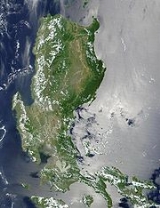
Geography
Luzon's area is 104,688 square kilometers, making it the world's 17th largest island. It is the fifth most populated island in the world. Located on Luzon are the country's capital, ManilaManila
Manila is the capital of the Philippines. It is one of the sixteen cities forming Metro Manila.Manila is located on the eastern shores of Manila Bay and is bordered by Navotas and Caloocan to the north, Quezon City to the northeast, San Juan and Mandaluyong to the east, Makati on the southeast,...
, and its most populated city, Quezon City
Quezon City
Quezon City is the former capital and the most populous city in the Philippines. Located on the island of Luzon, Quezon City is one of the cities and municipalities that make up Metro Manila, the National Capital Region. The city was named after Manuel L...
. The island is very mountain
Mountain
Image:Himalaya_annotated.jpg|thumb|right|The Himalayan mountain range with Mount Everestrect 58 14 160 49 Chomo Lonzorect 200 28 335 52 Makalurect 378 24 566 45 Mount Everestrect 188 581 920 656 Tibetan Plateaurect 250 406 340 427 Rong River...
ous and is home to Mount Pulag
Mount Pulag
Mount Pulag is the second highest mountain in the Philippines. It is Luzon’s highest peak at 2,922 meters above sea level. The borders between the provinces of Benguet, Ifugao, and Nueva Vizcaya meet at the mountain's peak....
, the third highest mountain in the country and Mount Pinatubo
Mount Pinatubo
Mount Pinatubo is an active stratovolcano located on the island of Luzon, near the tripoint of the Philippine provinces of Zambales, Tarlac, and Pampanga. It is located in the Tri-Cabusilan Mountain range separating the west coast of Luzon from the central plains, and is west of the dormant and...
, Mayon
Mayon Volcano
Mayon Volcano, also known as Mount Mayon, is an active volcano in the province of Albay, on the island of Luzon in the Philippines. Renowned as the "perfect cone" because of its almost symmetric conical shape, Mayon forms the northern boundary of Legazpi City, the largest city in terms of...
, and Taal Volcano
Taal Volcano
Taal Volcano is a complex volcano located on the island of Luzon in the Philippines. Historical eruptions are concentrated on Volcano Island, an island near the middle of Lake Taal. The lake partially fills Taal Caldera, which was formed by powerful prehistoric eruptions between 140,000 to 5,380 BP...
, Luzon's most famous volcano
Volcano
2. Bedrock3. Conduit 4. Base5. Sill6. Dike7. Layers of ash emitted by the volcano8. Flank| 9. Layers of lava emitted by the volcano10. Throat11. Parasitic cone12. Lava flow13. Vent14. Crater15...
es. To the west of Luzon island is the South China Sea
South China Sea
The South China Sea is a marginal sea that is part of the Pacific Ocean, encompassing an area from the Singapore and Malacca Straits to the Strait of Taiwan of around...
(Luzon Sea in Philippine territorial waters), to the east is the Philippine Sea
Philippine Sea
The Philippine Sea is a marginal sea east and north of the Philippines occupying an estimated surface area of 2 million mi² on the western part of the North Pacific Ocean...
, and to the north is Luzon Strait
Luzon Strait
The Luzon Strait is the strait between the island country of Taiwan and Luzon island of the Philippines. The strait thereby connects the Philippine Sea to the South China Sea in the western Pacific Ocean....
containing Babuyan Channel and Balintang Channel
Balintang Channel
The Balintang Channel is the small waterway that separates the Batanes and Babuyan Islands, both of which belong to the Philippines, in the Luzon Strait....
.
The main part of the island is roughly rectangular in shape and has the long Bicol Peninsula
Bicol Peninsula
Bicol is a peninsula of the Philippines. It is located on Luzon Island and is part of Bicol Region. The active Mayon Volcano is here....
protruding to the southeast. The northern part of the island contains the large mountain range
Mountain range
A mountain range is a single, large mass consisting of a succession of mountains or narrowly spaced mountain ridges, with or without peaks, closely related in position, direction, formation, and age; a component part of a mountain system or of a mountain chain...
, the Cordillera Central
Cordillera Central, Luzon
The Cordillera Central is a massive mountain range situated in the northern central part of the island of Luzon, in the Philippines. Several provinces bound it, namely Benguet, Abra, Kalinga, Apayao, Mountain Province, Ifugao, and Baguio, a chartered city located entirely within Benguet...
which is covered in a mixture of Luzon tropical pine forests
Luzon tropical pine forests
The Luzon tropical pine forests are a tropical coniferous forest ecoregion of the Philippines in the western Pacific Ocean. These pine forests are home to a large number of the island's endemic plants and animals.-Location and description:...
and Luzon montane rain forests. Mount Pulag
Mount Pulag
Mount Pulag is the second highest mountain in the Philippines. It is Luzon’s highest peak at 2,922 meters above sea level. The borders between the provinces of Benguet, Ifugao, and Nueva Vizcaya meet at the mountain's peak....
, the highest mountain in Luzon is located here, rising 2,922 meters.
To the east of the Cordillera Central is the large Cagayan Valley
Cagayan Valley
Cagayan Valley is a region of the Philippines, also designated as Region II or Region 02. It is composed of five provinces, namely: Batanes, Cagayan, Isabela, Nueva Vizcaya, and Quirino...
, which serves as the basin for the Cagayan River
Cagayan River
The Cagayan River is the longest and largest river in the Philippine Archipelago. It is located in the Cagayan Valley region in northeastern part of Luzon island and traverses the provinces of Nueva Vizcaya, Quirino, Isabela and Cagayan.-Topography:...
, the longest river in the Philippines. To the east of the valley rises the Sierra Madre
Sierra Madre (Philippines)
The Sierra Madre is a mountain range in The Philippines. It is located along the north-eastern coast of Luzon Island, running north/south. Quezon National Forest Park is situated in the range.-Geography:...
mountain range, easily the longest range in the country.
The Sierra Madre
Sierra Madre (Philippines)
The Sierra Madre is a mountain range in The Philippines. It is located along the north-eastern coast of Luzon Island, running north/south. Quezon National Forest Park is situated in the range.-Geography:...
snakes southwards into the central and southern part of the island. Between it and the Zambales Mountains
Zambales Mountains
The Zambales Mountains is a mountain range located on western Luzon island in the Philippines. The mountains separate Luzon's central plain from the South China Sea. Its most prominent section is known as the Tri-Cabusilan Mountain Range composed of Mt. Pinatubo, Mount Negron and Mount Cuadrado...
to the west is the largest plain, the Central Luzon plain. This plain, approximately 11,000 km² in size, is the country's largest producer of rice. Among the rivers irrigating this plain, the longest are Cagayan
Cagayan
Cagayan , the "Land of Smiling Beauty", is a province of the Philippines in the Cagayan Valley region in Luzon. Its capital is Tuguegarao City and is located at the northeastern corner of the island of Luzon. Cagayan also includes the Babuyan Islands to the north. The province borders Ilocos Norte...
to the north, and Pampanga
Pampanga River
Pampanga River is the second largest river in the island of Luzon, next to Cagayan River and the third largest river in the Philippines...
to the south. In the middle of the plain rises the solitary Mount Arayat
Mount Arayat
Mount Arayat is an extinct stratovolcano on Luzon Island, Philippines, rising to a height of There is no recorded eruption of the volcano, and its last activity probably dates to the Holocene era.The volcano is located in a flat agricultural region at...
. To the west, in the Zambales Mountains, rises Mount Pinatubo
Mount Pinatubo
Mount Pinatubo is an active stratovolcano located on the island of Luzon, near the tripoint of the Philippine provinces of Zambales, Tarlac, and Pampanga. It is located in the Tri-Cabusilan Mountain range separating the west coast of Luzon from the central plains, and is west of the dormant and...
, made famous because of its enormous 1991 eruption.
The Zambales mountains extends to the sea in the north, forming Lingayen Gulf
Lingayen Gulf
The Lingayen Gulf is an extension of the South China Sea on Luzon in the Philippines stretching . It is framed by the provinces of Pangasinan and La Union and sits between the Zambales Mountains and the Cordillera Central...
, home to the Hundred Islands National Park
Hundred Islands National Park
The Hundred Islands National Park is in the province of Pangasinan in northern Philippines. It is located in Alaminos City, Pangasinan. The islands are scattered along Lingayen Gulf and cover an area of 18.44 square kilometres . They are believed to be about two million years old...
. To the south, the mountains also extend into the sea, forming the Bataan Peninsula
Bataan Peninsula
The Bataan Peninsula is a rocky extension of the Zambales Mountains, on Luzon in the Philippines. It separates the Manila Bay from the South China Sea...
, which encloses the Manila Bay
Manila Bay
Manila Bay is a natural harbor which serves the Port of Manila , in the Philippines.The bay is considered to be one of the best natural harbors in Southeast Asia and one of the finest in the world...
. This natural harbor
Harbor
A harbor or harbour , or haven, is a place where ships, boats, and barges can seek shelter from stormy weather, or else are stored for future use. Harbors can be natural or artificial...
is considered to be one of the best natural ports in East Asia, due to its size and strategic geographical location.
To the southeast of Manila Bay
Manila Bay
Manila Bay is a natural harbor which serves the Port of Manila , in the Philippines.The bay is considered to be one of the best natural harbors in Southeast Asia and one of the finest in the world...
is the largest lake in the country, and also the largest inland lake in Southeast Asia, the Laguna de Bay
Laguna de Bay
Laguna de Bay is the largest lake in the Philippines and the third largest freshwater lake in Southeast Asia after Tonle Sap in Cambodia and Lake Toba in Sumatra, Indonesia. It is on the island of Luzon between the provinces of Laguna to the south and Rizal to the north...
(Old Spanish, Lake of Bay town). This 949 km² lake is drained by the Pasig River
Pasig River
The Pasig River is a river in the Philippines that connects Laguna de Bay to Manila Bay. Stretching for , it is lined by Metro Manila on each side...
into Manila Bay. Pasig River is one of the most important rivers in the country due to its historical significance and because it runs through the center of Metro Manila
Metro Manila
Metropolitan Manila , the National Capital Region , or simply Metro Manila, is the metropolitan region encompassing the City of Manila and its surrounding areas in the Philippines...
.
Located just 20 km southwest of Laguna de Bay is Taal Lake
Taal Lake
Taal Lake is a freshwater lake in the province of Batangas, on the island of Luzon, Philippines. The lake is situated within a caldera formed by very large eruptions between 500,000 and 100,000 years ago. It is the country's third largest lake...
, within the southwestern portion of the island. This caldera of a lake contains the smallest volcano
Volcano
2. Bedrock3. Conduit 4. Base5. Sill6. Dike7. Layers of ash emitted by the volcano8. Flank| 9. Layers of lava emitted by the volcano10. Throat11. Parasitic cone12. Lava flow13. Vent14. Crater15...
of the country, Taal Volcano
Taal Volcano
Taal Volcano is a complex volcano located on the island of Luzon in the Philippines. Historical eruptions are concentrated on Volcano Island, an island near the middle of Lake Taal. The lake partially fills Taal Caldera, which was formed by powerful prehistoric eruptions between 140,000 to 5,380 BP...
, which rises on the island in the center of the lake. The volcano in turn has a lake in its crater. All the surrounding areas of Taal Lake were once part of a massive prehistoric volcano that covered the southern portion of the province of Cavite, Tagaytay City, and the whole of Batangas province.
Off the southwestern portion of Luzon is the island of Mindoro, separated by the Verde Island Passages. The passages connect the South China Sea to the east with the Tayabas Bay
Tayabas Bay
Tayabas Bay is a large bay in the southern part of Luzon island, Philippines, at . Several islands are located in the bay, largest of which is Marinduque.Some of its parts is in Quezon Province Tayabas Bay is a large bay in the southern part of Luzon island, Philippines, at . Several islands are...
. To the south of the bay is the island of Marinduque.
The southeastern portion of Luzon is dominated by the Bicol Peninsula
Bicol Peninsula
Bicol is a peninsula of the Philippines. It is located on Luzon Island and is part of Bicol Region. The active Mayon Volcano is here....
. This is a mountainous and narrow region that extends approximately 150 km southeast. Along it are numerous gulfs and bays. In the north is Lamon Bay
Lamon Bay
Lamon Bay is a large bay in the southern part of Luzon island, Philippines, at .-Lamon Bay:It is a body of water connecting the southern part of Quezon province to the Pacific Ocean, and bounds the coastal towns of Atimonan, Gumaca, Plaridel, Lopez, Calauag, and the islands of Alabat. It is a rich...
, which contains Alabat Island
Alabat Island
Alabat Island is an island of the Philippine archipelago, in the Quezon Province of the CALABARZON region, situated just off the East coast of Southern Luzon...
and is south of the Polillo Islands of Quezon province
Quezon
-History:Originally, what now forms Quezon was divided among the provinces of Batangas, Laguna, and Nueva Ecija. The area was first explored by Juan de Salcedo in 1571-1572, during his expedition from Laguna to Camarines provinces....
. Other bays and gulfs include San Miguel Bay
San Miguel Bay
San Miguel Bay is a large bay in the southern part of Luzon island, Philippines, at ....
, Lagonoy Gulf
Lagonoy Gulf
Lagonoy Gulf is a large gulf in the southeastern part of Luzon island, Philippines, at . It is separated from the Philippine Sea by Caramoan Peninsula in the north....
, Ragay Gulf
Ragay Gulf
Ragay Gulf is a large gulf in the southern part of Luzon island, Philippines, at . It is separated from the Sibuyan Sea by Bondoc Peninsula in the west....
, and Sorsogon Bay
Sorsogon Bay
Sorsogon Bay is a large bay in the southern part of Luzon island, Philippines, at . It costs cover Pilar, Casiguran, Sorsogon City, Castilla and Magallanes....
.
To the east of the peninsula lies the island of Catanduanes. Leading to it is the Caramoan Peninsula
Caramoan Peninsula
Caramoan Peninsula is a hilly peninsula, with deep gorges and a rough, rocky terrain, located in north-east Camarines Sur, Bicol. The place has a National Park which has caves, limestone formations, white sandy beaches, an islet lake and a subterranean river, make it popular with tourists...
. Off the southeast tip of Bicol is Samar island, separated by San Bernardino Strait
San Bernardino Strait
The San Bernardino Strait is a strait in the Philippines. It separates the Bicol Peninsula of Luzon island from the island of Samar in the south.-Filipinos and San Bernardino Strait:...
. Bicol Peninsula is connected to the main part of Luzon through the Tayabas Isthmus
Tayabas Isthmus
Tayabas Isthmus, separates the Bicol Peninsula from the main part of Luzon Island, and the Bondoc Peninsula which lies between Tayabas Bay and Ragay Gulf....
. Extending south from the isthmus is the Bondoc Peninsula
Bondoc Peninsula
Bondoc Peninsula is a peninsula in Calabarzon Region, southern part of Luzon Island, Philippines, at ....
.
The Bicol Peninsula is also home to numerous volcanoes. The most famous is Mayon Volcano
Mayon Volcano
Mayon Volcano, also known as Mount Mayon, is an active volcano in the province of Albay, on the island of Luzon in the Philippines. Renowned as the "perfect cone" because of its almost symmetric conical shape, Mayon forms the northern boundary of Legazpi City, the largest city in terms of...
in Albay
Albay
Albay is a province of the Philippines located in the Bicol Region in Luzon. Its capital is Legazpi City and the province borders Camarines Sur to the north and Sorsogon to the south. Also to the northeast is Lagonoy Gulf....
. This 2,460 m high volcano is symmetrically shaped, rivaling that of Mount Fuji
Mount Fuji
is the highest mountain in Japan at . An active stratovolcano that last erupted in 1707–08, Mount Fuji lies about south-west of Tokyo, and can be seen from there on a clear day. Mount Fuji's exceptionally symmetrical cone is a well-known symbol of Japan and it is frequently depicted in art and...
in Japan
Japan
Japan is an island nation in East Asia. Located in the Pacific Ocean, it lies to the east of the Sea of Japan, China, North Korea, South Korea and Russia, stretching from the Sea of Okhotsk in the north to the East China Sea and Taiwan in the south...
, and is a symbol of the Bicol Region
Bicol Region
The Bicol Region or Bicolandia is one of the 17 regions of the Philippines. Its regional center is Legazpi City...
. Other notable mountains are Mount Isarog
Mount Isarog
Mount Isarog is a potentially active stratovolcano located in the province of Camarines Sur, Island of Luzon, Philippines.It was here that Bicolano guerillas hid during the Japanese Period...
and Mount Iriga
Mount Iriga
Mount Iriga, also known as Mount Asog, is one of the active volcanos in the Philippines, in the province of Camarines Sur, in the Philippines....
in Camarines Sur
Camarines Sur
Camarines Sur is a province of the Philippines located in the Bicol Region in Luzon. Its capital is Pili and the province borders Camarines Norte and Quezon to the north, and Albay to the south...
, and Mount Bulusan
Mount Bulusan
Mount Bulusan, or Bulusan Volcano, is the southernmost volcano on Luzon Island in the Republic of the Philippines. It is situated in the province of Sorsogon in the Bicol region, southeast of Mayon Volcano and approximately southeast of the Philippine capital of Manila.It is one of the active...
in Sorsogon
Sorsogon
Sorsogon is a province of the Philippines located in the Bicol Region; it is the southernmost province in Luzon and is subdivided into fourteen municipalities and one city. Its capital is Sorsogon City and borders the province of Albay to the north...
.
Located off the southwestern coast of the Bicol
Bicol Region
The Bicol Region or Bicolandia is one of the 17 regions of the Philippines. Its regional center is Legazpi City...
Peninsula are the islands of Ticao
Ticao Island
Ticao Island is one of the three major islands of Masbate Province in the Philippines. The other two major Islands are Masbate Island and Burias Island ....
, Burias
Burias Island
Burias Island is one of the three major islands of Masbate Province in the Philippines. The other two major Islands are Ticao Island and Masbate Island. The Island has two municipalities, Claveria and San Pascual....
, and Masbate.
Tectonics
Luzon is part of the Philippine Mobile BeltPhilippine Mobile Belt
The Philippine Mobile Belt is a complex portion of the tectonic boundary between the Eurasian Plate and the Philippine Sea Plate, comprising most of the country of the Philippines. It includes two subduction zones, the Manila Trench to the west and the Philippine Trench to the east, as well as the...
, a fast deforming plate boundary zone (Gervasio, 1967) hemmed in between two opposing subduction zones, the west-dipping Philippine Trench
Philippine Trench
The Philippine Trench is a submarine trench to the east of the Philippines. It has a length of approximately 1,320 km and a width of about 30 km from the centre of the Philippine island of Luzon trending southeast to the northern Maluku island of Halmahera in Indonesia...
-East Luzon Trench subduction zone, and the east-dipping north-south trending Manila Trench
Manila Trench
The Manila Trench is an ocean trench in the South China Sea, west of the Philippines. It reaches a depth of about 5,400 m, in contrast with the average depth of the South China Sea of about 1,500 m...
-Negros Trench-Cotabato Trench. The Philippine Sea Plate subducts under eastern Luzon along the East Luzon Trench and the Philippine Trench, while the South China Sea basin, part of the Eurasian plate
Eurasian Plate
The Eurasian Plate is a tectonic plate which includes most of the continent of Eurasia , with the notable exceptions of the Indian subcontinent, the Arabian subcontinent, and the area east of the Chersky Range in East Siberia...
, subducts under western Luzon along the Manila Trench.
The North-Southeastern trending braided left-lateral strike-slip Philippine Fault System
Philippine Fault System
The Philippine Fault System is an inter-related system of faults throughout the whole of the Philippine Archipelago, primarily caused by tectonic forces compressing the Philippines into what tectonic geophysicists call the Philippine Mobile Belt....
traverses Luzon, from Quezon province and Bicol
Bicol Region
The Bicol Region or Bicolandia is one of the 17 regions of the Philippines. Its regional center is Legazpi City...
to the northwestern part of the island. This fault system takes up part of the motion due to the subducting plates and produces large earthquakes. Southwest of Luzon is a collision zone where the Palawan micro-block collides with SW Luzon, producing a highly seismic zone near Mindoro
Mindoro
Mindoro is the seventh-largest island in the Philippines. It is located off the coast of Luzon, and northeast of Palawan. The southern coast of Mindoro forms the northeastern extremum of the Sulu Sea.-History:...
island. Southwest Luzon is characterized by a highly volcanic zone, called the Macolod Corridor, a region of crustal thinning and spreading.
Using geologic and structural data, seven principal blocks were identified in Luzon in 1989: the Sierra Madre Oriental, Angat, Zambales, Central Cordillera of Luzon, Bicol, and Catanduanes Island blocks. Using seismic and geodetic data, Luzon was modeled by Galgana et al. (2007) as a series of six micro blocks or micro plates (separated by subduction zones and intra-arc faults), all translating and rotating in different directions, with maximum velocities ~100 mm/yr NW with respect to Sundaland/Eurasia.
Economy
The economy of the island is centered in Metro ManilaMetro Manila
Metropolitan Manila , the National Capital Region , or simply Metro Manila, is the metropolitan region encompassing the City of Manila and its surrounding areas in the Philippines...
with Makati City
Makati City
The City of Makati is one of the 17 cities that make up Metro Manila, one of the most populous metropolitan areas in the world. Makati is the financial center of the Philippines and one of the major financial, commercial and economic hubs in Asia...
serving as the main economic and financial hub. Major companies such as Ayala
Ayala Corporation
Ayala Corporation is a holding company for the diversified interests of the Ayala Group. Founded in the Philippines by the Spanish and German Ayala, Roxas, and Zobel families during colonial rule, it is the country's oldest and largest conglomerate...
, Jollibee Foods Corporation, SM Group, and Metrobank
Metropolitan Bank and Trust Company
The Metropolitan Bank and Trust Company , commonly known as Metrobank. It has a diverse offering of financial services, from regular banking to insurance. Metrobank is the second largest bank in the Philippines.-History:...
are based in the business districts of Makati, Ortigas Center, and Bonifacio Global City. Industry is concentrated in and around the urban areas of Metro Manila while agriculture predominates in the other regions of the island producing crops such as rice, bananas, mangoes, coconuts, pineapple, and coffee. Other sectors include livestock raising, tourism, mining, and fishing.
History
Luzon was once split among HinduHinduism
Hinduism is the predominant and indigenous religious tradition of the Indian Subcontinent. Hinduism is known to its followers as , amongst many other expressions...
-Buddhist
Buddhism
Buddhism is a religion and philosophy encompassing a variety of traditions, beliefs and practices, largely based on teachings attributed to Siddhartha Gautama, commonly known as the Buddha . The Buddha lived and taught in the northeastern Indian subcontinent some time between the 6th and 4th...
kingdoms, Muslim principalities, and ethnoreligious
Philippine mythology
Philippine mythology include a collection of tales and superstitions about magical creatures and entities. Some Filipinos, even though heavily westernized and Christianized, still believe on these tales...
tribes, who had trading connections with Borneo
Borneo
Borneo is the third largest island in the world and is located north of Java Island, Indonesia, at the geographic centre of Maritime Southeast Asia....
, Malaya
Malay Peninsula
The Malay Peninsula or Thai-Malay Peninsula is a peninsula in Southeast Asia. The land mass runs approximately north-south and, at its terminus, is the southern-most point of the Asian mainland...
, Java
Java
Java is an island of Indonesia. With a population of 135 million , it is the world's most populous island, and one of the most densely populated regions in the world. It is home to 60% of Indonesia's population. The Indonesian capital city, Jakarta, is in west Java...
, Indochina
Indochina
The Indochinese peninsula, is a region in Southeast Asia. It lies roughly southwest of China, and east of India. The name has its origins in the French, Indochine, as a combination of the names of "China" and "India", and was adopted when French colonizers in Vietnam began expanding their territory...
, India
India
India , officially the Republic of India , is a country in South Asia. It is the seventh-largest country by geographical area, the second-most populous country with over 1.2 billion people, and the most populous democracy in the world...
, Okinawa
Ryukyu Islands
The , also known as the , is a chain of islands in the western Pacific, on the eastern limit of the East China Sea and to the southwest of the island of Kyushu in Japan. From about 1829 until the mid 20th century, they were alternately called Luchu, Loochoo, or Lewchew, akin to the Mandarin...
, Japan
Japan
Japan is an island nation in East Asia. Located in the Pacific Ocean, it lies to the east of the Sea of Japan, China, North Korea, South Korea and Russia, stretching from the Sea of Okhotsk in the north to the East China Sea and Taiwan in the south...
and China
China
Chinese civilization may refer to:* China for more general discussion of the country.* Chinese culture* Greater China, the transnational community of ethnic Chinese.* History of China* Sinosphere, the area historically affected by Chinese culture...
before the Spanish established their rule. From just before the first millennium, the Tagalog
Tagalog people
The Tagalog people are an ethnic group in the Philippines. The name Tagalog comes from either the native term tagá-ilog, meaning 'people living along the river', or another native term, tagá-alog, meaning 'people living along the ford', a ford being a shallow part of a river or stream where people,...
and Kapampangan
Kapampangan people
The Kapampangans or Capampan͠gans are the sixth largest Filipino ethnolinguistic group, numbering about 2,890,000. The original Kapampangans may have descended from Austronesian-speaking immigrants to Luzon during the Iron Age.The province of Pampanga is traditional homeland of the Kapampangans...
peoples of south and central Luzon had established several Indianized kingdoms, notably among them those of Tundok, Namayan
Kingdom of Namayan
The ancient Kingdom of Namayan, alternately referred to as the Kingdom of Sapa, Maysapan or Nasapan after its capital which goes by those names, was one of three major kingdoms that dominated the area around the upper portion of the Pasig River and the coast of Laguna Lake in the Philippines before...
and Maynila
Kingdom of Maynila
The Kingdom of Seludong , or Maynila, which after colonization became Manila, capital of the Philippines, was one of three major city-states that dominated the area around the upper portion of the Pasig River before the arrival of Spanish colonizers in the 16th century.The early inhabitants of the...
. The Laguna Copperplate Inscription
Laguna Copperplate Inscription
The Laguna Copperplate Inscription is the earliest known written document found in the Philippines. The plate was found in 1989 by a sand laborer working on Lumbang River near the outlet to Laguna de Bay, in Barangay Wawa, Lumban, in the Laguna province.The inscription on the plate was first...
, the first Philippine document written in 900AD, names places in and around Manila Bay
Manila Bay
Manila Bay is a natural harbor which serves the Port of Manila , in the Philippines.The bay is considered to be one of the best natural harbors in Southeast Asia and one of the finest in the world...
as well as Medan
Medan
- Demography :The city is Indonesia's fourth most populous after Jakarta, Surabaya, and Bandung, and Indonesia's largest city outside of Java island. Much of the population lies outside its city limits, especially in Deli Serdang....
in Indonesia. These kingdoms were based on leases between village rulers (Datu
Datu
Datu is the title for tribal chiefs, sovereign princes, and monarchs in the Visayas and Mindanao Regions of the Philippines. Together with Lakan , Apo in Central and Northern Luzon, Sultan and Rajah, they are titles used for native royalty, and are still currently used in the Philippines...
) and landlords (Lakan
Lakan
Lakan originally referred to a rank in the pre-Hispanic Filipino nobility in the island of Luzon, which means "paramount ruler." It has been suggested that this rank is equivalent to that of Rajah, and that different ethnic groups either used one term or the other, or used the two words...
) or Rajahs, to whom tributes and taxes were levied. These kingdoms were coastal thalassocracies
Thalassocracy
The term thalassocracy refers to a state with primarily maritime realms—an empire at sea, such as Athens or the Phoenician network of merchant cities...
based on trade with neighboring Asian political entities at that time. According to sources at the time, the trade in large native Rusun-tsukuri (literally Luzon made in Japanese:呂宋製 or 呂宋つくり) clay jars used for storing green tea
Green tea
Green tea is made solely from the leaves of Camellia sinensis that have undergone minimal oxidation during processing. Green tea originates from China and has become associated with many cultures throughout Asia. It has recently become more widespread in the West, where black tea is traditionally...
and rice wine
Rice wine
Rice wine is an alcoholic beverage made from rice. Unlike wine, which is made by fermentation of naturally sweet grapes and other fruit, rice "wine" results from the fermentation of rice starch converted to sugars...
with Japan flourished in the 12th century, and local Tagalog
Tagalog people
The Tagalog people are an ethnic group in the Philippines. The name Tagalog comes from either the native term tagá-ilog, meaning 'people living along the river', or another native term, tagá-alog, meaning 'people living along the ford', a ford being a shallow part of a river or stream where people,...
and Kapampangan
Kapampangan people
The Kapampangans or Capampan͠gans are the sixth largest Filipino ethnolinguistic group, numbering about 2,890,000. The original Kapampangans may have descended from Austronesian-speaking immigrants to Luzon during the Iron Age.The province of Pampanga is traditional homeland of the Kapampangans...
potters had marked each jar with Baybayin
Baybayin
Baybayin , is a pre-Spanish Philippine writing system. It is a member of the Brahmic family and is recorded as being in use in the 16th century...
letters denoting the particular urn used and the locale the jars were manufactured in. Of this flourishing trade, the Burnay jars of Ilocos
Ilocos
Ilocos collectively refers to two provinces in the Philippines: Ilocos Norte and Ilocos Sur. Inhabitants are called Ilocanos and they speak the language Iloko, also called Ilocano.The Ilocos Region, containing four provinces, is named after Ilocos...
are the only large clay jar manufactured in Luzon today with origins from this time.
The Portuguese
Portugal
Portugal , officially the Portuguese Republic is a country situated in southwestern Europe on the Iberian Peninsula. Portugal is the westernmost country of Europe, and is bordered by the Atlantic Ocean to the West and South and by Spain to the North and East. The Atlantic archipelagos of the...
were the first European explorers who recorded it in their charts as Luçonia or Luçon and inhabitants were called Luçoes
Luções
Luções or Luzones is the name that the Portuguese explorers in Southeast Asia used to refer to one of the ethnic groups that occupied the island of Luzon around the time of the early 16th century...
.
The Spanish arrival in the 16th century saw the breaking up of these kingdoms and the establishment of the Philippines with its capital Cebu, which was moved to Manila following the defeat of the local Rajah Sulayman
Rajah Sulayman
Rajah Sulayman was the Muslim Rajah of Maynila, a kingdom at the mouth of the Pasig River where it meets Manila Bay, at the time the Spanish forces first came to Luzon....
in 1570. Under Spain, Luzon also came to be known as the Nueva Castilla or the New Castile.
Demographics
Ethnic groups
The people of Luzon belong to the Filipino peopleFilipino people
The Filipino people or Filipinos are an Austronesian ethnic group native to the islands of the Philippines. There are about 92 million Filipinos in the Philippines, and about 11 million living outside the Philippines ....
, and are divided into several ethnolinguistic
Ethnolinguistics
Ethnolinguistics is a field of linguistics which studies the relationship between language and culture, and the way different ethnic groups perceive the world. It is the combination between ethnology and linguistics. The former refers to the way of life of an entire community i.e...
groups. These groups inhabit different areas of the island.
Ilocanos
Ilocano people
The Ilocano or Ilokano people are the third largest Filipino ethnolinguistic group. Aside from being referred to as Ilocanos, from "i"-from, and "looc"-bay, they also refer to themselves as Samtoy, from the Ilocano phrase "sao mi ditoy", meaning 'our language here.' The word "Ilocano" came from...
predominate in the northern portion of Ilocos
Ilocos Region
The Ilocos region or Region I is a Region of the Philippines and is located in the northwest of Luzon. It borders to the east the regions of the Cordillera Administrative Region and Cagayan Valley and to the south the region of Central Luzon...
and the region of Cagayan Valley, Pangasinense
Pangasinan people
The Pangasinan are the eighth largest Filipino ethnolinguistic group. They are the residents or indigenous peoples of the Province of Pangasinan, one of the provinces of the Republic of the Philippines, located on the west central area in the island of Luzon along Lingayen Gulf...
primarily inhabit Pangasinan
Pangasinan
Pangasinan is a province of the Republic of the Philippines. The provincial capital is Lingayen. Pangasinan is located on the west central and peripheral area of the island of Luzon along the Lingayen Gulf, with the total land area being 5,368.82 square kilometers . According to the latest census,...
, while the Kapampangans
Kapampangan people
The Kapampangans or Capampan͠gans are the sixth largest Filipino ethnolinguistic group, numbering about 2,890,000. The original Kapampangans may have descended from Austronesian-speaking immigrants to Luzon during the Iron Age.The province of Pampanga is traditional homeland of the Kapampangans...
primarily live in Pampanga
Pampanga
Pampanga is a province of the Philippines located in the Central Luzon region. Its capital is the City of San Fernando, Pampanga. Pampanga is bordered by the provinces of Bataan and Zambales to the west, Tarlac and Nueva Ecija to the north, and Bulacan to the southeast...
, Tarlac
Tarlac
Tarlac is a landlocked province of the Philippines located in the Luzon Island. Its capital is Tarlac City. Tarlac borders Pampanga to the south, Nueva Ecija to the east, Pangasinan to the north, and Zambales to the west...
and the rest of Central Luzon. Meanwhile, Tagalog
Tagalog people
The Tagalog people are an ethnic group in the Philippines. The name Tagalog comes from either the native term tagá-ilog, meaning 'people living along the river', or another native term, tagá-alog, meaning 'people living along the ford', a ford being a shallow part of a river or stream where people,...
s are the majority in Bulacan
Bulacan
Bulacan , officially called the Province of Bulacan or simply Bulacan Province, is a first class province of the Republic of the Philippines located in the Central Luzon Region in the island of Luzon, north of Manila , and part of the Metro...
, CALABARZON
CALABARZON
CALABARZON is one of the regions of the Philippines. It is also designated as Region IV-A and its regional center is Calamba City in Laguna...
, and Metro Manila
Metro Manila
Metropolitan Manila , the National Capital Region , or simply Metro Manila, is the metropolitan region encompassing the City of Manila and its surrounding areas in the Philippines...
, while Bicolanos
Bicolano people
The Bicolanos are the fifth-largest Filipino ethnolinguistic group.-Area:Bicolanos live in the southeastern peninsula of Luzon, now containing the provinces of Albay, Camarines Sur, Camarines Norte, Catanduanes, Masbate, and Sorsogon. Many Bicolanos also live near in the province of...
predominate in Bicol
Bicol Region
The Bicol Region or Bicolandia is one of the 17 regions of the Philippines. Its regional center is Legazpi City...
. Other ethnic groups are also present such as the Aeta
Aeta
The Aeta , Agta or Ayta are an indigenous people who live in scattered, isolated mountainous parts of Luzon, Philippines. They are considered to be Negritos, who are dark to very dark brown-skinned and tend to have features such as a small stature, small frame, curly to kinky afro-like textured...
of Zambales
Zambales
Zambales is a province of the Philippines located in the Central Luzon region. Its capital is Iba. Zambales borders Pangasinan to the north, Tarlac and Pampanga to the east, and Bataan to the south. The province lies between the South China Sea and the Zambales Mountains. With a land area of...
, the Ibanag of Cagayan, and the Igorot
Igorot
Cordillerans are the people of the Cordillera region, in the Philippines island of Luzon. The word, Igorot is a misnomer term invented by the Spaniards in mockery against the Nortnern Luzon tribes. The word ‘Igorot’ also as coined and applied by the Spaniards means a savage, head-hunting and...
of the Cordilleras
Cordillera Administrative Region
The Cordillera Administrative Region is a region in the Philippines composed of the provinces of Abra, Apayao, Benguet, Ifugao, Kalinga and Mountain Province, as well as Baguio City, the regional center. The Cordillera Administrative Region encompasses most of the areas within the Cordillera...
.
Due to recent migrations populations of Hindus, Moros, and Chinese have also been present in urban areas. Populations of Spanish, Americans, Japanese, Koreans
Koreans in the Philippines
Koreans in the Philippines, largely consisting of expatriates from South Korea, form the largest Korean diaspora community in Southeast Asia and the eighth-largest in the world, after Korean Australians and before Koreans in Kazakhstan; as of 2009, statistics of South Korea's Ministry of Foreign...
, Desi
Desi
Desi or Deshi refers to the people, cultures, and products of the Indian subcontinent and, increasingly, to the people, cultures, and products of their diaspora. Desi countries include India, Pakistan, Bangladesh...
s, and Filipino mestizo
Filipino mestizo
Filipino mestizo is a term used in the Philippines to describe people of mixed Filipino and foreign ancestry. The word mestizo is of Spanish origin, and was originally used in the Americas to only describe people of mixed European and Native American ancestry.- History :Spanish periodThe Spanish...
s are also visible. Most Americans have settled in Angeles City
Angeles City
The City of Angeles , located within the province of Pampanga in the Philippines, is locally classified as a first-class, highly-urbanized city. Its name is derived from El Pueblo de los Ángeles in honor of its patron saints, Los Santos Ángeles de los Custodios , and the name of its founder, Don...
and Olongapo City
Olongapo City
The City of Olongapo is a highly urbanized city located in the province of Zambales, Philippines. According to the latest census, it has a population of 227,270 people in 50,300 households.-History:...
due to the former presence of the U.S. air and naval bases in Central Luzon.
Languages
Almost all of the languages of Luzon belong to the Borneo–Philippines group of the Malayo-Polynesian languageMalayo-Polynesian languages
The Malayo-Polynesian languages are a subgroup of the Austronesian languages, with approximately 385.5 million speakers. These are widely dispersed throughout the island nations of Southeast Asia and the Pacific Ocean, with a smaller number in continental Asia...
branch of the Austronesian language family
Austronesian languages
The Austronesian languages are a language family widely dispersed throughout the islands of Southeast Asia and the Pacific, with a few members spoken on continental Asia that are spoken by about 386 million people. It is on par with Indo-European, Niger-Congo, Afroasiatic and Uralic as one of the...
. Major regional languages include: Tagalog
Tagalog language
Tagalog is an Austronesian language spoken as a first language by a third of the population of the Philippines and as a second language by most of the rest. It is the first language of the Philippine region IV and of Metro Manila...
, Ilocano
Ilokano language
Ilokano or Ilocano is the third most-spoken language of the Republic of the Philippines....
, Kapampangan
Kapampangan language
The Pampangan language, or Kapampangan , is one of the major languages of the Philippines. It is the language spoken in the province of Pampanga, the southern half of the province of Tarlac and the northern portion of the province of Bataan. Kapampangan is also understood in some barangays of...
, Bicol
Bikol language
Central Bicolano , is one of the individual languages of the Bikol languages. It belongs to Coastal Bikol. It is spoken in Bicol Region of the Philippines .-Bikol-Naga:...
, and Pangasinense
Pangasinan language
The Pangasinan language or Pangasinense is one of the twelve major languages in the Philippines....
. English
English language
English is a West Germanic language that arose in the Anglo-Saxon kingdoms of England and spread into what was to become south-east Scotland under the influence of the Anglian medieval kingdom of Northumbria...
is also used by many inhabitants.
Spain ruled the Philippines for 300 years. Spanish was the language of Philippine Revolution
Philippine Revolution
The Philippine Revolution , called the "Tagalog War" by the Spanish, was an armed military conflict between the people of the Philippines and the Spanish colonial authorities which resulted in the secession of the Philippine Islands from the Spanish Empire.The Philippine Revolution began in August...
, and the 1899 Malolos Constitution proclaimed it as the official language. However, its use declined following the American occupation of the Philippines, it is still used by the elderly members of some families of great tradition (Rizal, Liboro...)
Religion
The major religion present in the island is Christianity, the Roman Catholic ChurchRoman Catholic Church
The Catholic Church, also known as the Roman Catholic Church, is the world's largest Christian church, with over a billion members. Led by the Pope, it defines its mission as spreading the gospel of Jesus Christ, administering the sacraments and exercising charity...
having the major denomination. Other sects include Protestantism
Protestantism
Protestantism is one of the three major groupings within Christianity. It is a movement that began in Germany in the early 16th century as a reaction against medieval Roman Catholic doctrines and practices, especially in regards to salvation, justification, and ecclesiology.The doctrines of the...
, the Philippine Independent Church
Philippine Independent Church
The Philippine Independent Church, The Philippine Independent Church, The Philippine Independent Church, (officially the or the IFI, also known as the Philippine Independent Catholic Church or in Ilocano: Siwawayawaya nga Simbaan ti Filipinas (in in Kinaray-a/Hiligaynon: Simbahan Hilway nga...
, and Iglesia ni Cristo
Iglesia ni Cristo
Iglesia ni Cristo also known as INC, is the largest entirely indigenous Christian religious organization that originated from the Philippines and the largest independent church in Asia. Due to a number of similarities, some Protestant writers describe the INC's doctrines as restorationist in...
. Indigenous traditions and rituals are also present.
Sizable communities of Buddhist
Buddhism in the Philippines
Buddhism is a relatively minor religion in the Philippines. It is largely confined to the Filipino Chinese, Chinese, Japanese, Korean, Thai, and Vietnamese communities. There are temples in Manila, Davao, and Cebu, and other places. Estimates at the Buddhist population of the Philippines varies...
s and Muslim
Islam in the Philippines
Islam is the oldest recorded monotheistic religion in the Philippines. Islam reached the Philippines between the 12th and 14th century with the arrival of Muslim traders from Persian Gulf and the Malabar Coast in Southern India, and their followers from several sultanate governments in the Malay...
s have also began to be present in Metro Manila
Metro Manila
Metropolitan Manila , the National Capital Region , or simply Metro Manila, is the metropolitan region encompassing the City of Manila and its surrounding areas in the Philippines...
due to migrations of Moros and Chinese.
See also
- Regions of the PhilippinesRegions of the PhilippinesIn the Philippines, regions are administrative divisions that serve primarily to organize the provinces of the country for administrative convenience. Currently, the archipelagic republic of the Philippines is divided into 17 regions...
- Provinces of the PhilippinesProvinces of the PhilippinesThe Provinces of the Philippines are the primary political and administrative divisions of the Philippines. There are 80 provinces at present, further subdivided into component cities and municipalities. The National Capital Region, as well as independent cities, are autonomous from any provincial...
- Battle of LuzonBattle of LuzonThe Battle of Luzon was a land battle fought as part of the Pacific Theater of Operations of World War II by the Allied forces of the U.S., its colony The Philippines, and Mexico against forces of the Empire of Japan. The battle resulted in a U.S. and Filipino victory...