
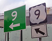
Croton Expressway
Encyclopedia
U.S. Route 9 is a part of the U.S. Highway System that runs from Laurel, Delaware
, to Champlain, New York
. In New York
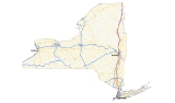
, US 9 extends 325.01 miles (523.05 km) from the George Washington Bridge
in Manhattan
to an interchange with Interstate 87 just south of the Canada – United States border in the town of Champlain. US 9 is the longest north–south U.S. Highway in New York; additionally, the portion of US 9 in New York accounts for more than half of the highway's total length.
The highway's passage through the state offers a diverse sample of New York
to a traveler, taking in busy urban neighborhoods, suburban strips and forested wilderness. It is Broadway
in Upper Manhattan
, the Bronx
and much of Westchester
. It uses parts of the old Albany Post Road
in the Hudson Valley
, where it passes the historic homes of a U.S. President
and Gilded Age
heir. It passes the center of New York political power in downtown Albany
, and the patrician grandeur of Saratoga Springs
. It penetrates into the deep recesses of the Adirondack Park and runs along the shore of Lake Champlain
, where it is part of the All-American Road known as the Lakes to Locks Passage
.
US 9 spawns more letter-suffixed state highways than any other route in New York, including the longest, 143 miles (230 km) NY 9N
. Outside of the cities it passes through, it is a mostly a two-lane road, save for two expressway
segments in the mid-Hudson region. For much of its southern half it follows the Hudson River
closely; in the north it tracks Interstate 87, the Adirondack Northway.
 The New York segment of US 9 can be divided into the section south of Albany, which parallels the Hudson River
closely; and the portion north of Albany, which takes in a long section of the eastern Adirondacks
. New York State Bicycle Route 9 follows the US 9 corridor, diverging from the route in areas not conducive to bicycling. For example, Bicycle Route 9 follows US 9W
in northern New Jersey
and Rockland County
, crosses the Bear Mountain Bridge
, and follows NY 9D
and NY 301
back to US 9 in Putnam County
.
 The concurrency between US 1 and US 9
that began in New Jersey ends at the first exit from Interstate 95
on the George Washington Bridge
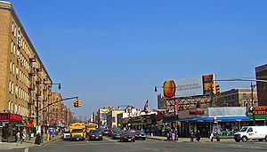
, when 9 heads north via 178th/179th Streets to Broadway. Broadway passes through the Washington Heights
neighborhood and then into Inwood
, the northernmost neighborhood on the island. Conspicuous Spanish-language
advertising testifies to the heavy Latin American
immigrant population in the area. The northernmost section of the New York City Subway
's underground IND Eighth Avenue Line
( train) runs along Broadway between Dyckman Street
and the Inwood – 207th Street terminal. On the corner of 204th Street is the Dyckman House
, the only original farmhouse left in Manhattan and a National Historic Landmark
.
Near the island's northern tip, at the intersection with 215th Street, the elevated IRT Broadway – Seventh Avenue Line ( train) of the New York City Subway joins Broadway. At the very tip of Manhattan, just past Columbia University
's Lawrence A. Wien Stadium
, Route 9 crosses the Harlem River Ship Canal
via the Broadway Bridge, into Marble Hill
, the only portion of Manhattan on the mainland. The Marble Hill Metro-North station
here is the first of several along Route 9.
 At or just south of 230th Street, 9, still Broadway, enters the Bronx
. It draws alongside Interstate 87, here the Major Deegan Expressway
, the first of many encounters between the two roads on their northward course. At the 242nd Street station, the subway ends and Broadway runs along the west side of Van Cortlandt Park
. The Henry Hudson Parkway
interchange a mile up this stretch adds NY 9A
to 9.
, where it is now known as South Broadway. It trends ever eastward, closer to the Hudson River
, remaining a busy urban commercial street. At downtown, it drops close to the river, becomes North Broadway and 9A leaves via Ashburton Avenue. 9 climbs to the nearby ridgetop runs parallel to the river and the railroad, a few blocks east of both as it passes St. John's Riverside Hospital. The neighborhoods become more residential and the road gently undulates along the ridgetop.
It remains Broadway as it leaves Yonkers for Hastings-on-Hudson
, where it splits into separate north and south routes for 0.6 mile (0.965604 km). The trees become taller and the houses, many separated from the road by stone fences, become larger. Another National Historic Landmark, the John William Draper House
, was the site of the first astrophotograph of the Moon
.
In the next village, Dobbs Ferry
, it passes Mercy College
, then turns left again at the center of town just past South Presbyterian Church
, headed for equally comfortable Ardsley-on-Hudson and Irvington
. Villa Lewaro
, the home of C.J. Walker, the first African-American millionaire, is along the highway here. At the north end of the village of Irvington, a memorial
to writer Washington Irving
, after whom the village was renamed, marks the turnoff to his home at Sunnyside
.
 North of here, at the Kraft Foods
technical center, the Tappan Zee Bridge
becomes visible, and after crossing under the Thruway
and I-87 again, here concurrent with Interstate 287, where the four-lane NY 119
splits off to the east, it becomes the busy main street of Tarrytown
. Christ Episcopal Church, where Irving worshipped, is along the street. This downtown ends at the eastern terminus of NY 448
, where 9 slopes off to the left, downhill, and four signs indicate that 9 turns left, passing the Old Dutch Church of Sleepy Hollow
, another NHL. The road then enters Sleepy Hollow
(formerly North Tarrytown), passing the visitors' center for Kykuit
, the National Historic Landmark
that was (and partially still is) the Rockefeller family
's estate
.
US 9 expands to four lanes at the trumpet intersection with NY 117
; Broadway finally ends and 9 becomes Albany Post Road. Entering Ossining's
downtown
, US 9 becomes Highland Avenue and continues to rise and fall, widen and narrow, through the riverside community.
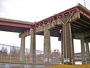
Just after Ossining, Route 9A returns and merges with US 9 for approximately 1,500 feet (457 m) as it crosses the mouth of the Croton River
and becomes the 9.2 miles (14.8 km) Croton Expressway. The only section built of the cancelled Interstate 487
, the highway is generally built to interstate standards. 9A leaves the freeway and returns to two lanes, following the parent route's old course, at the first exit, Croton Point Avenue in Croton-on-Hudson
, where NY 129
reaches its western end. Here the modern concrete
ramps of Metro-North's Croton-Harmon station
, also served by Amtrak
, are prominent to the west as Haverstraw Bay
becomes visible.
 The expressway veers inland for much of its route, preferring to follow the railroad tracks (the new Cortlandt
station is visible to the west at one point), rather than the river past the promontory at Buchanan
. NY 9A, as a surface street, ends at its parent at the Welcher Street exit. It continues on a reconstructed, widened section through Peekskill
. Despite recent upgrades to freeway standards, the northern end of the highway still maintains a lower 45 mi/h speed limit.
1 miles (1.6 km) from the freeway's northern terminus, US 202
and US 6
join the freeway. NY 35 reaches its western terminus at that same junction. The four-lane divided highway's northern terminus is at a stoplight at a three-way intersection with the Bear Mountain State Parkway
. The parkway continues straight from this intersection while 6/9/202 turns left.
 550 feet (168 m) north of that junction, the routes enter the Annsville traffic circle
. While 6 and 202 remain concurrent and exit the circle on its west side, continuing up the river, 9 exits the roundabout on the northeast side. It continues due north as, once again, two-lane Albany Post Road
. Running inland and mostly free of development behind the Hudson Highlands
, it enters Putnam County
. NY 403
reaches its eastern terminus at the same intersection where the Appalachian Trail
crosses the road. The gas station here has, when in service, long been a favorite stop for thru-hikers. A few miles further to the north, at the Indian Brook Road
intersection, the highway passes through Nelson's Corner, a rare surviving early 19th-century country hamlet. Old Albany Post Road
, a 6.6-mile (10.6 km) remnant of Route 9's original and one of the oldest dirt road
s still in use in the country, comes in from the right a mile on. The only other intersection of note in Putnam County is its main east–west state route, NY 301
, which crosses 9 several miles further north, just a mile south of the Dutchess County
line.
US 9 passes Dutchess Mall
, a dead mall
, and the historic Van Wyck Homestead
before meeting Interstate 84
in Fishkill
. At the interstate exit, the road expands into a four-lane strip similar to the form it takes in Central New Jersey
, complete with much commercial development on both sides. It will remain this way to Poughkeepsie. This stretch is an important, if often congested, transportation artery for the county.
Just north of I-84 9 clips off a corner of the village of Fishkill
, where the intersection with NY 52
creates a heavily congested situation at rush hours since traffic going from southbound 9 to westbound I-84 often uses it as a shortcut. The remaining miles to Wappingers Falls
boast many intersections as well, but are not quite as heavy.
In the Town of Poughkeepsie
, just after the northern terminus of NY 9D
, 9 passes another distressed mall, South Hills
and its healthier, newer counterpart, the Poughkeepsie Galleria
. A mile further north, NY 113
swings to the west at a cloverleaf interchange
near the IBM
plant, once the region's major employer. Entering the city of Poughkeepsie
, at Sharon Drive, 9 returns to expressway status once again. 2 miles (3.2 km) north of Sharon, the highway connects to the US 44/NY 55
concurrency at an interchange in close proximity to the Mid-Hudson Bridge
. This creates some unusual left exits, as traffic from 44/55 east wanting to go north on 9 is routed into a U-turn south of the highway, and likewise northbound drivers on 9 must get turned around to go west over the river. The limited-access highway comes to an end at the intersection with NY 9G
near Marist College
.
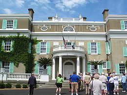 North of Poughkeepsie 9 is at first a busy four-lane undivided route, with occasional turn lanes as it approaches Hyde Park
, passing the Culinary Institute of America
and then the home
and presidential library
of native Franklin D. Roosevelt
. It narrows to two lanes at the built-up area that marks the center of town, then opens up a turn lane for traffic entering the third of the town's tourist attractions, Vanderbilt Mansion National Historic Site
.
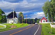
Past Hyde Park, the road narrows to two lanes again as traffic becomes more local. The area recalls Westchester County with many wooded tracts and stone walls at roadside. Through here it has been running fairly close to the river, but after Staatsburg
the highway begins to veer inland again. The land to the west, between road and river, forms the Hudson River Historic District
, the largest in the country and another National Historic Landmark. Route 9 is at least 2 miles (3 km) east of the river when it reaches Rhinebeck
, the next town along the route, where NY 308
heads off to the east.
At Weys Corners, the X-shaped intersection north of Rhinebeck, northbound traffic to the river and the Kingston-Rhinecliff Bridge
via NY 199
typically bears left onto NY 9G. Southbound traffic, in turn, takes 199 itself to the river when the two meet in Red Hook
3 miles (5 km) further ahead. Two blocks north of that junction are the Village Diner
, originally named the Halfway Diner since it was roughly halfway along Route 9 from New York City to Albany, and the Elmendorph Inn
, a mid-18th century counterpart to the diner. North of Red Hook, the land around the road begins to open up into farms and fields, offering frequent views of the Catskill Escarpment
across the river. This terrain continues into Columbia County
, which 9 enters 5 miles (8 km) beyond Red Hook.
 The road remains two lanes, with mostly local traffic and no stop signs or traffic lights, until the oblique four-way intersection in Belle Pond, 10 miles (16 km) into the county. Here, NY 23
joins 9 as it heads west, which in turn joins NY 9H
on the northern roadway while NY 82
departs to the southeast. 1.5 miles (2.4 km) west, in Greenport
, 9 turns northward again toward Hudson
, the county seat, passing the St. Lawrence
-owned cement
plant whose expansion was recently blocked by community activists after two contentious years.
On the east fringe of Hudson's historic downtown
, US 9 intersects the northern terminus of NY 9G and NY 23B
. Route 23B runs concurrent with 9 for a short distance eastward before splitting at Fairview Avenue, which US 9 follows out of Hudson. A commercial strip with turn lane gives way after 1.75 miles (2.82 km) to the lightly traveled rural two-lane 9 north of Hudson. Near Stockport
, Route 9 meets the southern terminus of NY 9J
. Farther north, after passing through Kinderhook
, home of another U.S. president, Martin Van Buren
, the road passes under NY 9H at a grade-separated
interchange before intersecting the northern terminus of 9H a short distance later outside Valatie
. When a developer wanted to add a fifth leg to this intersection for a new shopping center, the state Department of Transportation
required the developer to convert the signalized intersection to a roundabout
, despite heavy local opposition.
 The highway widens to four lanes with a turn lane shortly after crossing into Renesslaer County
, and will remain so for most of the rest of the way to Albany
, despite limited development and low traffic in some areas. Within a mile of the county line it passes under the New York State Thruway
Berkshire Connector and meets the lone section of Interstate 90
in New York
not part of the Thruway system, at exit 12 southeast of Castleton-on-Hudson
. 4 miles (6 km) north of I-90 and 4 miles (6 km) northwest of Nassau
, Route 9 veers left to merge with US 20
in Schodack Center
, and together they progress northwest toward Albany. Less than 0.5 mile (0.80467 km) from the eastern terminus of the overlap, 9 and 20 intersect NY 150
before connecting to I-90 at exit 11.
As the roadway heads westward, it meets the western (southern for state purposes) terminus of US 4
across from a Hannaford
supermarket along the busy commercial strip in East Greenbush. Shortly afterwards the first sign of the state capital, the Erastus Corning Tower
, starts becoming visible. At a bluff east of the river, the entire Albany skyline comes into view as the road descends, passing the northern terminus of NY 9J south of Rensselaer
. Routes 9 and 20 then cross the Hudson River
via the Dunn Memorial Bridge
into Albany as Corning Tower and the other buildings of Empire State Plaza
loom ahead, and the two routes separate, with 20 heading west across the city.
, US 9 starts to pull away from the Hudson corridor, eventually picking up I-87
, now the Adirondack Northway.
. Here it intersects the two routes which have paralled 9 up the west side of the Hudson. At Pearl Street and the Palace Theatre
, it crosses NY 32
(North Pearl Street), which continues north, and US 9W
(Lark Street), which ends at the junction. Route 9 turns north on Henry Johnson Boulevard and widens to cross I-90 again via a flyover
originally built for the canceled Mid-Crosstown Arterial, exiting the city of Albany in the process.
 Just before reaching the northern suburb of Colonie, 9 returns to two lanes and follows Loudon Road through well-to-do residential neighborhoods past Albany Memorial Hospital and Wolferts Roost Country Club. The short NY 377
forks off to the north while Route 9 trends slightly westward. A five-way intersection marks Loudonville
. Siena College
in Newtonville
is on the east side a mile past the junction, with the headquarters of New York State Police
Troop G opposite.
Continuing northward into Latham
, the highway adds a middle turn lane. NY 155
intersects as the Northway draws near to the west. Beyond, the road expands to four lanes and commercial property resumes. At the Latham Circle
9 crosses beneath NY 2
. It is used also to give access to westbound NY 7
. A mile further north, the expressway portion of Route 7 crosses over for eastbound traffic, and then NY 9R
goes off to the east, to return 2 miles (3 km) further north. At the junction, 9 starts to trend eastward again, away from the Northway, and finally crosses the Mohawk River
into Saratoga County
via the Crescent Bridge at the northernmost point of Albany County.
A new name, Halfmoon Parkway, comes with the change of county, after the town
the road runs through. The eastward bent reverses itself as another state route, NY 236
forks off to the north. By the time 9 reaches the NY 146
junction in Clifton Park
, the Northway is right alongside again. The roads continue running parallel courses past Round Lake
as NY 67
joins 9 into Malta
, leaving 1.6 miles (2.6 km) later at the center of town for its own exit along the Northway. Another 1.5 miles (2.4 km) to the north, another lettered subroute of US 9, NY 9P
, leaves east for Saratoga Lake.
 Route 9 itself has its first exit with the Northway, its first junction with I-87 since Tarrytown in fact, 2 miles (3 km) north of 9P. This full cloverleaf is the main exit for Saratoga Springs
. The resort town's historic downtown
is 4 miles (6 km) ahead, past Saratoga Spa State Park
and Congress Park
. Here 9, as South Broadway, begins a concurrency with NY 50
and, later, briefly, with NY 29
. 9P completes its loop here, and another lettered route, NY 9N
, the longest letter-suffixed route in the state, begins at the post office
. Tacking eastward out of town, 9 and 50 follow Van Dam Street until 9 returns to a northerly course on Marion Avenue, which becomes Maple Avenue at the city limit.
as it gets less developed through Wilton
and Moreau
. The Palmerstown Range begins to rise on one side, anticipating the mountainous country to come. From the hamlet of Kings Station onward, what is now signed as Saratoga Road follows a straight northeast course for 10 miles (16 km) through more wooded countryside to the entrance to Moreau Lake State Park
. A mile further on, 9 again intersects the Northway at exit 17.
Another 1.5 miles (2.4 km) brings it to the western end of NY 197
(Reynolds Road). US 9 continues straight ahead for the next 3 miles (5 km) into the village of South Glens Falls
, where NY 32 (Gansevoort Road), comes in at an oblique angle from the south and merges with 9 to cross the Hudson via the Cooper's Cave Bridge for the last time, leave Saratoga County and enter the Warren County
city of Glens Falls
.
The two routes follow Glen Street to a five-way intersection in the center of town, where 32 leaves to the right via Warren Street and NY 9L
takes Ridge Street due north. 9 continues via Glen to the northwest, becoming Upper Glen Street at the city limit. NY 254
(Aviation Road) comes in from its nearby western terminus at the Northway. The highway remains heavily developed for the next 3 miles (5 km) to a junction with another route beginning at I-87, NY 149
. It joins with US 9 briefly before leaving to the east north of the Adirondack-Lake George Outlet Mall. Many vehicles make that turn, as 149 is the best route from the Northway into southern Vermont
, 30 miles (48 km) to the east.
Route 9 continues to parallel the interstate. At the Queensbury
-Lake George
town line, a massive wooden shingle lets drivers know they have crossed the Blue Line
into the Adirondack Park. The route straightens out for the next 2.5 miles (4 km) into the village of Lake George
, a popular tourist destination.
It takes the name Canada Street, and NY 9N comes in from the west to run concurrently with. The two routes widen to a busy four-lane road past shops catering to a busy tourist trade. Shortly thereafter, NY 9L loops back to the parent route, after having followed the east shore of the lake
that gives the village its name. At the northern end of the village of Lake George, 9N splits via Lake Shore Drive to follow the western shore, and 9 itself takes a northwesterly turn to remain parallel with the Northway.
east of the Mississippi
, 6100000 acres (24,685.8 km²) with vast tracts of Forest Preserve
kept "forever wild" per the state constitution. Accordingly, 9 remains a two-lane rural road, often very close to the Northway, throughout the park. Development, traffic and population are minimal, the surrounding land is heavily wooded and the two roads cover very long, lonely distances between very small, solitary towns.
After Lake George, there is another exit with the Northway, to ease access to the village by southbound traffic. US 9 remains very close to the Northway on its east side, resulting in another exit 4 miles (6 km) north. This serves Warrensburg
, where NY 418
reaches its eastern terminus. The highway begins to move further away from the interstate and 3 miles (5 km) further, NY 28
concludes its long bow-shaped route at a junction with 9.
 Nearly 9 miles (14 km) north, at Chestertown
, Route 9 meets and joins NY 8
, which carries it due west almost 4 miles (6 km) to Loon Lake
. After crossing over a southwestern bay of the lake, 9 turns right and is once again on its own, trending northeast alongside the lake's western shore to eventually reach the Northway again in 4 miles (6 km). This exit serves only northbound traffic. A mile later, there is access for the other direction.
The road begins to run along the west shore of Schroon Lake, in the process crossing into Essex County
. Shortly after the county line, an access road leads to I-87 again. It is 7 miles (11 km) from here, past the hamlet of Schroon Lake at the water's northern tip, that 9 intersects NY 74
, like 254 and 149 fresh off its western terminus at the Northway. Signs at this junction use Ticonderoga
, 17 miles (27 km) to the east, as a control city
, an indication of how sparsely populated the park is.
9 remains close to the interstate for the next 16 miles (26 km) into the town of North Hudson
, where Boreas Road provides access to the Dix Mountain Wilderness Area
the southernmost in the Adirondack High Peaks region. The highway again crosses the interstate to connect I-87 to the western terminus of NY 73
, the well-traveled scenic route to Keene Valley and Lake Placid
. At this ornate junction, 9 is at 1,155 feet (340 m) above sea level, the highest elevation it reaches along its entire length.
The right turn takes it again to the northeast past Rocky Peak Ridge
and the Giant Mountain Wilderness Area
, to the hamlet of New Russia. This 10 miles (16 km) stretch brings the highway to Elizabethtown
, the unincorporated county seat
and the first settlement 9 has passed through since Warrensburg. NY 9N comes through town from the west; it and US 9 briefly overlap.
While the land remains mostly forested as the road continues its northeast course from Elizabethtown, it begins to descend somewhat as the valley of Lake Champlain
draws near. 9 eventually draws close to the Northway again at Poke-O-Moonshine Mountain, the Adirondacks' most popular climbing
spot. In Chesterfield
, 18 miles (29 km) without a major highway junction are ended when NY 22
joins 9 after its exit, the first pairing of two highways that begin their journey upstate in New York City.
The two routes enter Keeseville
, where in mid-village they cross the Ausable River and enter Clinton County
. NY 9N reappears here, reaching its northern terminus. North of the village, the two routes split again and exchange the roles they had been playing for their entire northward journey. 9 takes the eastward fork to the lake, running close to the state's edge; while 22 will run inland from here to the border.
After Keeseville, 9 follows AuSable Chasm down to the lake shore. It crosses the Ausable and briefly re-enters Essex County long enough for the short NY 373
to provide access to the Port Kent-Burlington Ferry. A third and final crossing takes it out of the Adirondack Park.
comes in from the east at the small hamlet of Peru
, 9 heads down to the shore of the lake itself, which it will stay close to all the way into Plattsburgh as Lakes to Locks Passage. On clear days it is possible to see Burlington
across the water. Ahead lies Valcour Island
. In the narrow, rocky strait between it and the shore, Benedict Arnold
's hastily built fleet held off the British
on October 11, 1776 in the Battle of Valcour Island
in what is considered the first battle of U.S. naval history
. More recent military history is apparent shortly thereafter when 9 passes now-closed Plattsburgh Air Force Base
, a pillar of the regional economy Plattsburgh has struggled to replace.
 When it actually enters Plattsburgh
, it becomes first U.S. Avenue, then Peru Street when it passes the Old Catholic Cemetery. The Saranac River
draws alongside twice before 9 takes a left turn at Bridge Street and crosses it. Just past the bridge, the highway turns left again onto City Hall Place at the center of town. Route 9 passes in front of the City Hall
designed by John Russell Pope
, also the builder of the Jefferson Memorial
in Washington. Two more quick lefts follow past the large obelisk
of Riverside Park, onto Miller and Cornelia streets, then 9 turns right at the eastern terminus of the lengthy NY 3
to follow Margaret Street north and out of the city.
It bends northeast to return to the lake shore shortly after the city limit, following alongside Cumberland Bay
. At the Dead Creek crossing, 9 widens to four lanes for the first time since the Albany area to handle the heavy traffic at the junction with NY 314
, another ferry connector, just southeast of the Northway. 2 miles (3 km) north of the junction, after North Country Shopping Center, the highway returns to two lanes and the name Lakes to Locks Passage as it overlooks Woodruff Pond and Treadwell Bay. I-87 is visible a thousand feet (305 m) to the east across the many open fields as the two roads parallel each others turns closely.
Another short route, NY 456
, comes in from the west and terminates at 9 shortly after the right turn for Point Au Roche State Park
. Continuing northward, the road deviates to the east slightly in the Town of Chazy
, but returns to its previous track by the interstate at the Little Chazy River bridge. Shortly afterwards, NY 191
(Miner Farm Road) comes in from the west.
Route 9 runs straight, no longer taking another name, and due north 3 miles (5 km) to the next major intersection, NY 9B
(Lavalley Road), its last subroute. 9B does not terminate but instead runs to the lakeshore and eventually north to Rouses Point
. A bend slightly to the west, closer to the Northway, brings the next 3 miles (5 km) stretch to 9's last major intersection, US 11
, just south of Champlain
.
US 9 winds through the quiet border village as its Main Street, turning west-northwest near Champlain's northern boundary to make its last water crossing over the Chazy River
. 9, still known as Main Street, heads northwest towards the Northway to follow it for the last 0.5 mile (0.80467 km) passing a few customs brokerages
towards its official end at the onramp to the last exit. Traffic to Canada must get on I-87 here.
The roadway continues as the East Service Road, unsigned NY 971B, for another 0.5 mile (0.80467 km). This was the former route of US 9 to the border prior to the construction of the Northway. It is devoid of any development save some long vacant and abandoned lots, finally ending in a parking lot
400 feet (121.9 m) south of the border from which the Canadian customs station
at the south end of Autoroute 15
is visible.
was assigned an unsigned legislative route
designation by the New York State Legislature in 1908. Route 2 joined modern US 9 at Archville (north of Tarrytown
) and followed it north to Croton-on-Hudson
, where it turned off to the northeast on modern NY 129
. The legislative route rejoined what is now US 9 at Peekskill
and remained on it to Valatie
, where it met Route 1. Route 2 ended here while Route 1 continued north to Albany
on current US 9. From Albany to Clifton Park
and from South Glens Falls
to Riparius, modern US 9 was part of Route 25. At Riparius, Route 25 met Route 22, which utilized what is now US 9 from Riparius to Elizabethtown
and from Keeseville
to the town of Champlain
. While modern US 9 travels directly from Elizabethtown to Keeseville and bypasses Rouses Point
to the west, Route 25 used current NY 9N
between Elizabethtown and Keeseville and served Rouses Point via modern NY 9B
. Routes 2 and 25 were realigned slightly on March 1, 1921, to utilize the modern US 9 corridor from Croton-on-Hudson to Peekskill and from Saratoga Springs
to South Glens Falls, respectively.
When the first set of posted routes in New York were assigned in 1924, the general routing of modern US 9 was designated as NY 6, which went from the New York City
line at Yonkers
north to the Canadian border near Rouses Point
. From New York City, NY 6 followed current US 9 north to Tarrytown, where it joined legislative Route 2 and continued north through Valatie to Albany via legislative Routes 1 and 2. North of Albany, NY 6 served Cohoes
, Mechanicville
, and Round Lake
via modern NY 32
and NY 67
. At Round Lake, NY 6 rejoined the path of current US 9 and headed north to Saratoga Springs. Past Saratoga Springs, NY 6 continued to Rouses Point on legislative Routes 22 and 25.
 In the original 1925 plan for the U.S. Highway System, US 9 was designated along the west bank of the Hudson River
from the New Jersey
line to Albany, utilizing then-NY 10
. North of Albany, US 9 mostly followed NY 6 to Canada. The lone deviation was from Elizabethtown to Keeseville, where US 9 was routed on a previously unnumbered highway to the east instead. NY 6 east of the Hudson (up to Rensselaer) and a further extension to Glens Falls via Troy
, Mechanicville, and Schuylerville
was designated as US 109. The alignment of US 9 within New York remained unchanged in the final system alignment approved on November 11, 1926. However, when US 9 was commissioned in New York in 1927, the US 109 designation had been dropped and was signed instead as US 9E, but only up to Waterford. The segment on the west bank of the Hudson from New Jersey to Waterford was redesignated as US 9W
, with the split routes meeting in Waterford. From there, unsuffixed US 9 began (still along NY 6) and went up to the Canadian border via Rouses Point as planned in 1925.
The former routing of NY 6 between Elizabethtown and Keeseville, bypassed by US 9, became NY 9W at this time. A shorter, more inland alternate route between Albany and Round Lake was designated as NY 9C sometime in the late 1920s. In the 1930 renumbering of state highways in New York, the "E" suffix was dropped from all of US 9E south of East Greenbush—making it part of US 9—while US 9W was truncated southward to end in Albany. At the same time, US 9 was realigned between Albany and Round Lake to use what had been NY 9C. The Waterford–Mechanicville portion of US 9's former routing and the segment of US 9E between East Greenbush and Waterford became part of an extended US 4. The remainder of the old riverside route south of Waterford became part of NY 32 while the Round Lake – Mechanicville segment of old US 9 became part of NY 67.
. It was shifted northward onto the George Washington Bridge
when it opened in 1934. In mid-December 1934, US 9 was signed within New York City for the first time, as were several other U.S. Highways and state routes. US 9 followed the George Washington Bridge into Manhattan, where it continued east on 179th Street to Broadway
. Here, US 9 turned north as it does today, following Broadway through Manhattan and The Bronx
to Yonkers. The route was moved from 179th Street to the Cross Bronx Expressway ca. 1963 following the completion of the highway in the vicinity of the eastern bridge approach.
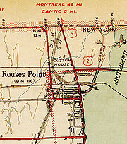
 In the mid-1940s, the northern end of US 9 was realigned to enter Canada via Champlain instead of Rouses Point. The old route through Rouses Point became NY 9B
. In the mid-1960s, the Adirondack Northway was completed in the vicinity of Champlain, supplanting the northernmost 1 miles (1.6 km) of US 9. US 9 initially overlapped with Interstate 87 from exit 43 to the Canadian border; however, it was truncated to end at exit 43—the last interchange before the border—in the 1970s. Part of US 9's former routing to the border was retained as a service road and was designated as NY 971B, an unsigned reference route.
(up to Tarrytown). In 1956, there were plans to continue the expressway further north to Interstate 84
in Beacon and beyond. This was one of the proposed alignments for Interstate 87.
In early 1965, this unconstructed expressway was assigned the designation Interstate 487, allowing a commercial-vehicle-accessible means of travel on the east side of the Hudson River
. By 1967, strong resident opposition caused the segment from Peekskill to Beacon to be cancelled. In 1971, the section from Tarrytown to Ossining had also been cancelled due to lack of public support. The only portion that was ever built was the section from Crotonville to Peekskill, and was later named the Croton Expressway. The Croton Expressway opened in 1967 with the US 9 designation. The original surface alignment of US 9 became an extension of NY 9A
.
 In Albany, US 9 was planned to be upgraded to an expressway. It was to run west from the Dunn Memorial Bridge along the South Mall Arterial
(co-signed with US 20), then north along the northern half of the Mid-Crosstown Arterial. The southern half would carry US 9W. The Mid-Crosstown Arterial would have begun at the junction of Interstate 787 and the New York State Thruway
, connect with the South Mall Arterial at an underground interchange at Washington Park, and continue north to a junction with Interstate 90. The only portion that was actually constructed was in the vicinity of the I-90 interchange (exit 6).
A study by the National Highway Traffic Safety Administration
in 2009 found that US 9 was the deadliest highway in Dutchess County
, with 47 fatal accidents on the road in the 1994–2008 period. Police in the town of Poughkeepsie
blamed it on the increasing commercialization of US 9 south of the city of Poughkeepsie.
|rowspan=5|New York
|rowspan=7|New York City
|0.00
| colspan="2" style="text-align:center;"|I-95
/ US 1/US 9
continue west across the George Washington Bridge
into New Jersey
|-
|0.55
|
|Exit 1A (I-95 / US 1 / US 9); exit 14 (NY 9A / Henry Hudson Parkway)
|-
|0.84
|
|Exit 1A (I-95 / US 1 / US 9); eastern terminus of I-95 / US 1 / US 9 overlap
|-
|3.06
| colspan="2" style="text-align:center;"|Broadway Bridge over the Harlem River Ship Canal
|-
|rowspan=2|3.16
| rowspan="2" colspan="2" style="text-align:center;"|West 230th Street
|-
|rowspan=2|Bronx
|-
|4.98
|
|Exit 23 (NY 9A / Henry Hudson Parkway); southern terminus of US 9 / NY 9A overlap
|-
|rowspan=12|Westchester
|Yonkers
|7.85
|
|Northern terminus of US 9 / NY 9A overlap
|-
|Tarrytown
|17.07
|
|Exit 9 (I-87/I-287/Thruway); western terminus of NY 119
|-
|rowspan=2|Sleepy Hollow
|18.68
|
|Western terminus of NY 448
|-
|20.38
|
|Interchange; western terminus of NY 117
|-
|rowspan=2|Ossining
|24.11
|
|Western terminus of NY 133
|-
|25.76
|
|Southern terminus of US 9 / NY 9A overlap
|-
|rowspan=2|Croton-on-Hudson
|26.41
|
|Interchange; northern terminus of US 9 / NY 9A overlap
|-
|29.88
|
|Interchange
|-
|Buchanan
|32.91
|
|Interchange; northern terminus of NY 9A
|-
|rowspan=3|Peekskill
|34.36
|
|Southern terminus of US 6 / US 9 and US 9 / US 202 overlaps; western terminus of NY 35
|-
|34.97
|
|Western terminus of Bear Mountain Parkway
|-
|35.09
|
|Annsville Circle; northern terminus of US 6 / US 9 and US 9 / US 202 overlaps
|-
|rowspan=2|Putnam
|Garrison
|38.96
|
|Southern terminus of NY 403
|-
|Cold Spring
|45.44
|
|
|-
|rowspan=9|Dutchess
|rowspan=2|Fishkill
|52.16
|
|Exit 13 (I-84)
|-
|53.08
|
|
|-
|Wappingers Falls
|58.90
|
|Northern terminus of NY 9D
|-
|Town of Poughkeepsie
|61.85
|
|Interchange
|-
|City of Poughkeepsie
|65.19
|
|Interchange
|-
|Town of Poughkeepsie
|66.56
|
|Southern terminus of NY 9G; formerly NY 9F
|-
|rowspan=2|Rhinebeck
|81.56
|
|Western terminus of NY 308
|-
|83.91
|
|
|-
|Red Hook
|86.86
|
|
|-
|rowspan=7|Columbia
|Livingston
|101.59
|
|Southern terminus of US 9 / NY 23 overlap
|-
|Greenport
|104.27
|
|Northern terminus of US 9 / NY 23 overlap
|-
|rowspan=2|Hudson
|107.22
|
|Western terminus of US 9 / NY 23B overlap; northern terminus of NY 9G
|-
|107.73
|
|Eastern terminus of US 9 / NY 23B overlap
|-
|Stockport
|113.85
|
|Southern terminus of NY 9J
|-
|rowspan=2|Valatie
|120.62
|
|
|-
|122.41
|
|Northern terminus of NY 9H
|-
|rowspan=7|Rensselaer
|rowspan=4|Schodack
|127.00
|
|Exit 12 (I-90)
|-
|131.35
|
|Eastern terminus of US 9 / US 20 overlap
|-
|131.72
|
|
|-
|132.23
|
|Exit 11 (I-90)
|-
|East Greenbush
|135.41
|
|Southern terminus of US 4
|-
|rowspan=2|Rensselaer
|138.20
|
|Northern terminus of NY 9J
|-
|rowspan=2|139.46
| rowspan="2" colspan="2" style="text-align:center;"|Dunn Memorial Bridge
over Hudson River
|-
|rowspan=14|Albany
|rowspan=6|Albany
|-
|139.52
|
|Western terminus of US 9 / US 20 overlap
|-
|139.84
|
|Exits 3 and 4 (I-787)
|-
|140.72
|
|
|-
|141.35
|
|Northern terminus of US 9W
|-
|142.08
|
|Exit 6 (I-90)
|-
|rowspan=8|Colonie
|142.83
|
|Interchange; southern terminus of NY 377
|-
|144.88
|
|Western terminus of NY 378
|-
|147.19
|
|
|-
|147.98
|
|Latham Circle; 9 passes underneath
|-
|148.70
|
|
|-
|149.01
|
|Exit 7 (I-87/NY 7); southern terminus of NY 9R
|-
|150.57
|
|Northern terminus of NY 9R
|-
|rowspan=2 |153.41
| rowspan="2" colspan="2" style="text-align:center;"|Crescent Bridge over the Mohawk River
|-
|rowspan=16|Saratoga
|rowspan=3|Halfmoon
|-
|154.47
|
|Southern terminus of NY 236
|-
|156.91
|
|
|-
|Round Lake
– Malta
line
|163.25
|
|Southern terminus of US 9 / NY 67 overlap
|-
|rowspan=3|Malta
|164.83
|
|Northern terminus of US 9 / NY 67 overlap
|-
|166.31
|
|Southern terminus of NY 9P
|-
|168.43
|
|Exit 13 (I-87)
|-
|rowspan=5|Saratoga Springs
|172.00
|
|Southern terminus of US 9 / NY 50 overlap
|-
|172.30
|
|Northern terminus of NY 9P
|-
|172.33
|
|Southern terminus of US 9 / NY 29 overlap
|-
|172.55
|
|Northern terminus of US 9 / NY 29 overlap; southern terminus of NY 9N
|-
|173.53
|
|Northern terminus of US 9 / NY 50 overlap
|-
|rowspan=2|Moreau
|184.58
|
|Exit 17 (I-87)
|-
|186.02
|
|Western terminus of NY 197
|-
|rowspan=2|South Glens Falls
|189.26
|
|Southern terminus of US 9 / NY 32 overlap
|-
|rowspan=2|190.46
| rowspan="2" colspan="2" style="text-align:center;"|Cooper's Cave Bridge over the Hudson River
|-
|rowspan=16|Warren
|rowspan=2|Glens Falls
|-
|190.76
|
|Northern terminus of US 9 / NY 32 overlap; southern terminus of NY 9L
|-
|rowspan=3|Queensbury
|192.85
|
|
|-
|195.90
|
|Exit 20 (I-87); southern terminus of US 9 / NY 149 overlap
|-
|196.40
|
|Northern terminus of US 9 / NY 149 overlap
|-
|rowspan=4|Lake George
|199.01
|
|Southern terminus of US 9 / NY 9N overlap
|-
|199.34
|
|Northern terminus of NY 9L
|-
|200.89
|
|Northern terminus of US 9 / NY 9N overlap
|-
|201.12
|
|Exit 22 (I-87)
|-
|rowspan=2|Hamlet of Warrensburg
|205.42
|
|Exit 23 (I-87)
|-
|206.20
|
|Eastern terminus of NY 418
|-
|Town of Warrensburg
|209.62
|
|Northern terminus of NY 28
|-
|rowspan=4|Chester
|218.24
|
|Eastern terminus of US 9 / NY 8 overlap
|-
|222.06
|
|Western terminus of US 9 / NY 8 overlap
|-
|226.79
|
|Southern half of exit 26 (I-87)
|-
|227.62
|
|Northern half of exit 26 (I-87)
|-
|rowspan=7|Essex
|rowspan=2|Schroon
|231.49
|
|Exit 27 (I-87)
|-
|238.43
|
|To I-87 exit 28
|-
|rowspan=2|North Hudson
|254.33
|
|Exit 30 (I-87)
|-
|256.47
|
|Eastern terminus of NY 73
|-
|rowspan=2|Elizabethtown
|266.43
|
|Western terminus of US 9 / NY 9N overlap
|-
|266.89
|
|Eastern terminus of US 9 / NY 9N overlap
|-
|Chesterfield
|284.22
|
|Southern terminus of US 9 / NY 22 overlap
|-
|Clinton
|Keeseville
|288.79
|
|Northern terminus of US 9 / NY 22 overlap; northern terminus of NY 9N
|-
|Essex
|Chesterfield
|290.41
|
|Western terminus of NY 373
|-
|rowspan=8|Clinton
|Peru
|294.16
|
|Eastern terminus of NY 442
|-
|City of Plattsburgh
|303.10
|
|Eastern terminus of NY 3
|-
|Town of Plattsburgh
|305.16
|
|
|-
|Beekmantown
|309.37
|
|Eastern terminus of NY 456
|-
|Chazy
|317.40
|
|Eastern terminus of NY 191
|-
|Town of Champlain
|320.08
|
|Western terminus of NY 9B
|-
|Village of Champlain
|323.28
|
|
|-
|Town of Champlain
|325.01
|
|Exit 43 (I-87); northern terminus of US 9; roadway continues north for 0.54 mile (0.8690436 km) as NY 971B
Laurel, Delaware
As of the census of 2000, there were 3,668 people, 1,389 households, and 957 families residing in the town. The population density was 2,215.9 people per square mile . There were 1,561 housing units at an average density of 943.0 per square mile...
, to Champlain, New York
Champlain (town), New York
Champlain is a town in Clinton County, New York, United States. The population was 5,754 at the 2010 census. The town is named after Lake Champlain....
. In New York
New York
New York is a state in the Northeastern region of the United States. It is the nation's third most populous state. New York is bordered by New Jersey and Pennsylvania to the south, and by Connecticut, Massachusetts and Vermont to the east...
, US 9 extends 325.01 miles (523.05 km) from the George Washington Bridge
George Washington Bridge
The George Washington Bridge is a suspension bridge spanning the Hudson River, connecting the Washington Heights neighborhood in the borough of Manhattan in New York City to Fort Lee, Bergen County, New Jersey. Interstate 95 and U.S. Route 1/9 cross the river via the bridge. U.S...
in Manhattan
Manhattan
Manhattan is the oldest and the most densely populated of the five boroughs of New York City. Located primarily on the island of Manhattan at the mouth of the Hudson River, the boundaries of the borough are identical to those of New York County, an original county of the state of New York...
to an interchange with Interstate 87 just south of the Canada – United States border in the town of Champlain. US 9 is the longest north–south U.S. Highway in New York; additionally, the portion of US 9 in New York accounts for more than half of the highway's total length.
The highway's passage through the state offers a diverse sample of New York
New York
New York is a state in the Northeastern region of the United States. It is the nation's third most populous state. New York is bordered by New Jersey and Pennsylvania to the south, and by Connecticut, Massachusetts and Vermont to the east...
to a traveler, taking in busy urban neighborhoods, suburban strips and forested wilderness. It is Broadway
Broadway (New York City)
Broadway is a prominent avenue in New York City, United States, which runs through the full length of the borough of Manhattan and continues northward through the Bronx borough before terminating in Westchester County, New York. It is the oldest north–south main thoroughfare in the city, dating to...
in Upper Manhattan
Upper Manhattan
Upper Manhattan denotes the more northerly region of the New York City Borough of Manhattan. Its southern boundary may be defined anywhere between 59th Street and 155th Street. Between these two extremes lies the most common definitions of Upper Manhattan as Manhattan above 96th Street...
, the Bronx
The Bronx
The Bronx is the northernmost of the five boroughs of New York City. It is also known as Bronx County, the last of the 62 counties of New York State to be incorporated...
and much of Westchester
Westchester County, New York
Westchester County is a county located in the U.S. state of New York. Westchester covers an area of and has a population of 949,113 according to the 2010 Census, residing in 45 municipalities...
. It uses parts of the old Albany Post Road
Albany Post Road
The Albany Post Road was a post road - a road used for mail delivery - in the U.S. state of New York. It connected the cities of New York and Albany along the east side of the Hudson River, a service now performed by US 9.The rough route was as follows:...
in the Hudson Valley
Hudson Valley
The Hudson Valley comprises the valley of the Hudson River and its adjacent communities in New York State, United States, from northern Westchester County northward to the cities of Albany and Troy.-History:...
, where it passes the historic homes of a U.S. President
President of the United States
The President of the United States of America is the head of state and head of government of the United States. The president leads the executive branch of the federal government and is the commander-in-chief of the United States Armed Forces....
and Gilded Age
Gilded Age
In United States history, the Gilded Age refers to the era of rapid economic and population growth in the United States during the post–Civil War and post-Reconstruction eras of the late 19th century. The term "Gilded Age" was coined by Mark Twain and Charles Dudley Warner in their book The Gilded...
heir. It passes the center of New York political power in downtown Albany
Albany, New York
Albany is the capital city of the U.S. state of New York, the seat of Albany County, and the central city of New York's Capital District. Roughly north of New York City, Albany sits on the west bank of the Hudson River, about south of its confluence with the Mohawk River...
, and the patrician grandeur of Saratoga Springs
Saratoga Springs, New York
Saratoga Springs, also known as simply Saratoga, is a city in Saratoga County, New York, United States. The population was 26,586 at the 2010 census. The name reflects the presence of mineral springs in the area. While the word "Saratoga" is known to be a corruption of a Native American name, ...
. It penetrates into the deep recesses of the Adirondack Park and runs along the shore of Lake Champlain
Lake Champlain
Lake Champlain is a natural, freshwater lake in North America, located mainly within the borders of the United States but partially situated across the Canada—United States border in the Canadian province of Quebec.The New York portion of the Champlain Valley includes the eastern portions of...
, where it is part of the All-American Road known as the Lakes to Locks Passage
Lakes to Locks Passage
The New York State byway known as Lakes to Locks Passage unifies the interconnected waterway of the upper Hudson River, Champlain Canal, Lake George, and Lake Champlain; this waterway is the core of North America’s first “super-highway” between upstate New York, USA and the Province of Quebec, Canada...
.
US 9 spawns more letter-suffixed state highways than any other route in New York, including the longest, 143 miles (230 km) NY 9N
New York State Route 9N
New York State Route 9N is a north–south state highway in northeastern New York, United States. It extends from an intersection with U.S. Route 9 , NY 29, and NY 50 in the city of Saratoga Springs to a junction with US 9 and NY 22 in the Clinton County village of...
. Outside of the cities it passes through, it is a mostly a two-lane road, save for two expressway
Limited-access road
A limited-access road known by various terms worldwide, including limited-access highway, dual-carriageway and expressway, is a highway or arterial road for high-speed traffic which has many or most characteristics of a controlled-access highway , including limited or no access to adjacent...
segments in the mid-Hudson region. For much of its southern half it follows the Hudson River
Hudson River
The Hudson is a river that flows from north to south through eastern New York. The highest official source is at Lake Tear of the Clouds, on the slopes of Mount Marcy in the Adirondack Mountains. The river itself officially begins in Henderson Lake in Newcomb, New York...
closely; in the north it tracks Interstate 87, the Adirondack Northway.
Route description
Hudson River
The Hudson is a river that flows from north to south through eastern New York. The highest official source is at Lake Tear of the Clouds, on the slopes of Mount Marcy in the Adirondack Mountains. The river itself officially begins in Henderson Lake in Newcomb, New York...
closely; and the portion north of Albany, which takes in a long section of the eastern Adirondacks
Adirondack Mountains
The Adirondack Mountains are a mountain range located in the northeastern part of New York, that runs through Clinton, Essex, Franklin, Fulton, Hamilton, Herkimer, Lewis, Saint Lawrence, Saratoga, Warren, and Washington counties....
. New York State Bicycle Route 9 follows the US 9 corridor, diverging from the route in areas not conducive to bicycling. For example, Bicycle Route 9 follows US 9W
U.S. Route 9W
U.S. Route 9W is a north–south U.S. Highway in the states of New Jersey and New York. It begins on Fletcher Avenue in Fort Lee, New Jersey as it crosses the US 1 & 9, US 46, and the Interstate 95 approaches to the George Washington Bridge, where it heads north up the west...
in northern New Jersey
New Jersey
New Jersey is a state in the Northeastern and Middle Atlantic regions of the United States. , its population was 8,791,894. It is bordered on the north and east by the state of New York, on the southeast and south by the Atlantic Ocean, on the west by Pennsylvania and on the southwest by Delaware...
and Rockland County
Rockland County, New York
Rockland County is a suburban county 15 miles to the northwest of Manhattan and part of the New York City Metropolitan Area, in the U.S. state of New York. It is the southernmost county in New York west of the Hudson River, and the smallest county in New York outside of New York City. The...
, crosses the Bear Mountain Bridge
Bear Mountain Bridge
The Bear Mountain Bridge is a toll suspension bridge in New York State, carrying U.S. Highways 202 and 6 across the Hudson River between Rockland and Westchester counties...
, and follows NY 9D
New York State Route 9D
New York State Route 9D , also known as the Bear Mountain – Beacon Highway, is a north–south state highway that runs along the eastern shore of the Hudson River in New York in the United States. It starts at the eastern end of the Bear Mountain Bridge at U.S...
and NY 301
New York State Route 301
New York State Route 301 is an intra-county state highway stretching across three-quarters of Putnam County, New York, in the United States. The western terminus of NY 301 is at an intersection with NY 9D in Cold Spring. Its eastern terminus is at a junction with NY 52 in...
back to US 9 in Putnam County
Putnam County, New York
Putnam County is a county located in the U.S. state of New York, in the lower Hudson River Valley. Putnam county formed in 1812, when it detached from Dutchess County. , the population was 99,710. It is part of the New York Metropolitan Area. The county seat is the hamlet of Carmel...
.
New York City and the Hudson Valley
US 9 enters New York as part of an expressway, soon becoming a surface street and major urban and suburban artery. Outside of the expressway portions, it is mostly a two- or four-lane road save for a lengthy four-lane strip that leads into one of the expressways. It runs near the river more frequently in the southern areas, but it is never very far inland.New York City
U.S. Route 1/9
U.S. Route 9 is a U.S. highway in the northeast United States, running from Laurel, Delaware north to the Canadian border near Champlain, New York...
that began in New Jersey ends at the first exit from Interstate 95
Interstate 95 in New York
Interstate 95 is a part of the Interstate Highway System that runs from Miami, Florida, to the Canada – United States border near Houlton, Maine. In the U.S. state of New York, I-95 extends from the George Washington Bridge in New York City to the Connecticut state line at Port Chester...
on the George Washington Bridge
George Washington Bridge
The George Washington Bridge is a suspension bridge spanning the Hudson River, connecting the Washington Heights neighborhood in the borough of Manhattan in New York City to Fort Lee, Bergen County, New Jersey. Interstate 95 and U.S. Route 1/9 cross the river via the bridge. U.S...
, when 9 heads north via 178th/179th Streets to Broadway. Broadway passes through the Washington Heights
Washington Heights, Manhattan
Washington Heights is a New York City neighborhood in the northern reaches of the borough of Manhattan. It is named for Fort Washington, a fortification constructed at the highest point on Manhattan island by Continental Army troops during the American Revolutionary War, to defend the area from the...
neighborhood and then into Inwood
Inwood, Manhattan
Inwood is the northernmost neighborhood on Manhattan Island in the New York City borough of Manhattan.-Geography:Inwood is physically bounded by the Harlem River to the north and east, and the Hudson River to the west. It extends southward to Fort Tryon Park and alternatively Dyckman Street or...
, the northernmost neighborhood on the island. Conspicuous Spanish-language
Spanish language
Spanish , also known as Castilian , is a Romance language in the Ibero-Romance group that evolved from several languages and dialects in central-northern Iberia around the 9th century and gradually spread with the expansion of the Kingdom of Castile into central and southern Iberia during the...
advertising testifies to the heavy Latin American
Latin American culture
Latin American culture is the formal or informal expression of the peoples of Latin America, and includes both high culture and popular culture as well as religion and other customary practices....
immigrant population in the area. The northernmost section of the New York City Subway
New York City Subway
The New York City Subway is a rapid transit system owned by the City of New York and leased to the New York City Transit Authority, a subsidiary agency of the Metropolitan Transportation Authority and also known as MTA New York City Transit...
's underground IND Eighth Avenue Line
IND Eighth Avenue Line
The Eighth Avenue Line is a rapid transit line in New York City, United States, and is part of the B Division of the New York City Subway...
( train) runs along Broadway between Dyckman Street
Dyckman Street (IND Eighth Avenue Line)
Dyckman Street is a station on the IND Eighth Avenue Line of the New York City Subway, located at the intersection of Dyckman Street and Broadway in the Inwood neighborhood of Manhattan...
and the Inwood – 207th Street terminal. On the corner of 204th Street is the Dyckman House
Dyckman House
The Dyckman Farmhouse is the oldest remaining farmhouse on Manhattan island, a reminder of New York City's rural past. The Dutch Colonial-style farmhouse was built by Dutch farmer William Dyckman, circa 1784, and was originally part of several of farmland owned by the family...
, the only original farmhouse left in Manhattan and a National Historic Landmark
National Historic Landmark
A National Historic Landmark is a building, site, structure, object, or district, that is officially recognized by the United States government for its historical significance...
.
Near the island's northern tip, at the intersection with 215th Street, the elevated IRT Broadway – Seventh Avenue Line ( train) of the New York City Subway joins Broadway. At the very tip of Manhattan, just past Columbia University
Columbia University
Columbia University in the City of New York is a private, Ivy League university in Manhattan, New York City. Columbia is the oldest institution of higher learning in the state of New York, the fifth oldest in the United States, and one of the country's nine Colonial Colleges founded before the...
's Lawrence A. Wien Stadium
Lawrence A. Wien Stadium
Robert K. Kraft Field at Lawrence A. Wien Stadium at Baker Athletics Complex is a stadium located at the northern tip of the island of Manhattan in New York in the Inwood neighborhood. It is primarily used for gridiron football, lacrosse, and track and field events, and is the home field of the...
, Route 9 crosses the Harlem River Ship Canal
Harlem River Ship Canal
The Harlem River Ship Canal is a channel connecting the Hudson River and Spuyten Duyvil Creek to the Harlem River in New York City, separating the neighborhood of Marble Hill from the island of Manhattan...
via the Broadway Bridge, into Marble Hill
Marble Hill, Manhattan
Marble Hill is the neighborhood which makes up the northernmost part of the Borough of Manhattan in New York City, United States. Although it is politically part of Manhattan and New York County, because of the re-routing of the Harlem River, it is located on the North American mainland contiguous...
, the only portion of Manhattan on the mainland. The Marble Hill Metro-North station
Marble Hill (Metro-North station)
The Marble Hill Metro-North Railroad station serves the residents of the Marble Hill neighborhood of Manhattan in New York City via the Hudson Line and is one of four express stations on that line south of Croton–Harmon seeing most trains minus peak hour trains to/from Poughkeepsie...
here is the first of several along Route 9.
The Bronx
The Bronx is the northernmost of the five boroughs of New York City. It is also known as Bronx County, the last of the 62 counties of New York State to be incorporated...
. It draws alongside Interstate 87, here the Major Deegan Expressway
Major Deegan Expressway
The Major Deegan Expressway is a north–south expressway in the New York City borough of the Bronx...
, the first of many encounters between the two roads on their northward course. At the 242nd Street station, the subway ends and Broadway runs along the west side of Van Cortlandt Park
Van Cortlandt Park
Van Cortlandt Park is a park located in the Bronx in New York City. It is the fourth largest park in New York City, behind Pelham Bay Park, Flushing Meadows Park and Staten Island Greenbelt....
. The Henry Hudson Parkway
Henry Hudson Parkway
The Henry Hudson Parkway is an long parkway in New York City. The southern terminus is at West 72nd Street in Manhattan, where the parkway continues south as the West Side Highway. It is often erroneously referred to as the West Side Highway throughout its entire course in Manhattan...
interchange a mile up this stretch adds NY 9A
New York State Route 9A
New York State Route 9A is a state highway in the vicinity of New York City, New York, United States. Its southern terminus is at the northern end of the Brooklyn–Battery Tunnel in New York City, where it intersects with both Interstate 478 and FDR Drive. The northern terminus of...
to 9.
Westchester County
The northwestern corner of the park marks the city limit and 9 enters YonkersYonkers, New York
Yonkers is the fourth most populous city in the state of New York , and the most populous city in Westchester County, with a population of 195,976...
, where it is now known as South Broadway. It trends ever eastward, closer to the Hudson River
Hudson River
The Hudson is a river that flows from north to south through eastern New York. The highest official source is at Lake Tear of the Clouds, on the slopes of Mount Marcy in the Adirondack Mountains. The river itself officially begins in Henderson Lake in Newcomb, New York...
, remaining a busy urban commercial street. At downtown, it drops close to the river, becomes North Broadway and 9A leaves via Ashburton Avenue. 9 climbs to the nearby ridgetop runs parallel to the river and the railroad, a few blocks east of both as it passes St. John's Riverside Hospital. The neighborhoods become more residential and the road gently undulates along the ridgetop.
It remains Broadway as it leaves Yonkers for Hastings-on-Hudson
Hastings-on-Hudson, New York
Hastings-on-Hudson is a village in Westchester County, New York, United States. It is located in the southwest part of the town of Greenburgh. As of the 2010 census, it had a population of 7,849. It lies on U.S. Route 9, "Broadway" in Hastings...
, where it splits into separate north and south routes for 0.6 mile (0.965604 km). The trees become taller and the houses, many separated from the road by stone fences, become larger. Another National Historic Landmark, the John William Draper House
John William Draper House
The John William Draper House, also known as Draper Park, is located on US 9 in Hastings-on-Hudson, New York, USA. It was the home of John William Draper, 1811-1882. His son Henry Draper, 1837-1882, created an observatory on the estate...
, was the site of the first astrophotograph of the Moon
Moon
The Moon is Earth's only known natural satellite,There are a number of near-Earth asteroids including 3753 Cruithne that are co-orbital with Earth: their orbits bring them close to Earth for periods of time but then alter in the long term . These are quasi-satellites and not true moons. For more...
.
In the next village, Dobbs Ferry
Dobbs Ferry, New York
Dobbs Ferry is a village in Westchester County, New York, United States. The population was 10,875 at the 2010 census.The Village of Dobbs Ferry is located in, and is a part of, the town of Greenburgh...
, it passes Mercy College
Mercy College (New York)
Mercy College is a private, non-profit liberal arts college with its main campus in Dobbs Ferry, New York, and satellite locations throughout southeastern New York, including the Bronx, Manhattan, White Plains and Yorktown...
, then turns left again at the center of town just past South Presbyterian Church
South Presbyterian Church
South Presbyterian Church, usually just referred to as South Church, is located along Broadway in Dobbs Ferry, New York, United States. Founded in 1820, it is currently in its second building, a stone Gothic Revival style structure dating to 1869...
, headed for equally comfortable Ardsley-on-Hudson and Irvington
Irvington, New York
Irvington, sometimes known as Irvington-on-Hudson, is an affluent suburban village in the town of Greenburgh in Westchester County, New York, United States. It is located on the eastern bank of the Hudson River, north of midtown Manhattan in New York City, and is served by a station stop on the...
. Villa Lewaro
Villa Lewaro
Villa Lewaro, also known as the Anne E. Poth Home, is located at Fargo Lane and North Broadway in Irvington, New York. It was the home of Madam C. J. Walker from 1918 to 1919. She is believed to be the first American female and first African-American female, self-made millionaire...
, the home of C.J. Walker, the first African-American millionaire, is along the highway here. At the north end of the village of Irvington, a memorial
Washington Irving Memorial
The Washington Irving Memorial is located at Broadway and West Sunnyside Lane in Irvington, New York, United States. It features a bust of Irving and sculptures of two of his better-known characters by Daniel Chester French, set in a small stone plaza at the street corner designed by Charles A....
to writer Washington Irving
Washington Irving
Washington Irving was an American author, essayist, biographer and historian of the early 19th century. He was best known for his short stories "The Legend of Sleepy Hollow" and "Rip Van Winkle", both of which appear in his book The Sketch Book of Geoffrey Crayon, Gent. His historical works...
, after whom the village was renamed, marks the turnoff to his home at Sunnyside
Sunnyside (Tarrytown, New York)
Sunnyside is a historic house on 10 acres of grounds alongside the Hudson River in Tarrytown, New York. It was formerly the home of noted early American author Washington Irving, best known for his short stories "The Legend of Sleepy Hollow" and "Rip Van Winkle", and is a National Historic...
.
Kraft Foods
Kraft Foods Inc. is an American confectionery, food and beverage conglomerate. It markets many brands in more than 170 countries. 12 of its brands annually earn more than $1 billion worldwide: Cadbury, Jacobs, Kraft, LU, Maxwell House, Milka, Nabisco, Oscar Mayer, Philadelphia, Trident, Tang...
technical center, the Tappan Zee Bridge
Tappan Zee Bridge
The Governor Malcolm Wilson Tappan Zee Bridge, usually referred to as Tappan Zee Bridge, is a cantilever bridge in New York over the Hudson River at one of its widest points; the Tappan Zee is named for an American Indian tribe from the area called "Tappan"; and zee being the Dutch word for "sea"....
becomes visible, and after crossing under the Thruway
New York State Thruway
The New York State Thruway is a system of limited-access highways located within the state of New York in the United States. The system, known officially as the Governor Thomas E. Dewey Thruway for former New York Governor Thomas E. Dewey, is operated by the New York State Thruway Authority and...
and I-87 again, here concurrent with Interstate 287, where the four-lane NY 119
New York State Route 119
New York State Route 119 is an east–west state highway in Westchester County, New York, in the United States. The road starts in Tarrytown at an intersection with U.S. Route 9 and comes to an end at a junction with NY 22 in White Plains...
splits off to the east, it becomes the busy main street of Tarrytown
Tarrytown, New York
Tarrytown is a village in the town of Greenburgh in Westchester County, New York, United States. It is located on the eastern bank of the Hudson River, about north of midtown Manhattan in New York City, and is served by a stop on the Metro-North Hudson Line...
. Christ Episcopal Church, where Irving worshipped, is along the street. This downtown ends at the eastern terminus of NY 448
New York State Route 448
New York State Route 448 is a long state highway in western Westchester County, New York in the United States. The route begins in the village of Sleepy Hollow at U.S. Route 9 and goes in a northeast direction through the Pocantico Hills community in Mount Pleasant...
, where 9 slopes off to the left, downhill, and four signs indicate that 9 turns left, passing the Old Dutch Church of Sleepy Hollow
Old Dutch Church of Sleepy Hollow
The Old Dutch Church of Sleepy Hollow, listed on the National Register of Historic Places as Dutch Reformed Church , is a 17th century stone church located on Albany Post Road in Sleepy Hollow, New York, United States. It and its five-acre churchyard feature prominently in Washington Irving's...
, another NHL. The road then enters Sleepy Hollow
Sleepy Hollow, New York
Sleepy Hollow is a village in the town of Mount Pleasant in Westchester County, New York, United States. It is located on the eastern bank of the Hudson River, about north of midtown Manhattan in New York City, and is served by the Philipse Manor stop on the Metro-North Hudson Line.Originally...
(formerly North Tarrytown), passing the visitors' center for Kykuit
Kykuit
Kykuit , also known as John D. Rockefeller Estate, is a 40-room National Trust house in Westchester County, New York, built by the oil businessman, philanthropist and founder of the prominent Rockefeller family, John D. Rockefeller, and his son, John D...
, the National Historic Landmark
National Historic Landmark
A National Historic Landmark is a building, site, structure, object, or district, that is officially recognized by the United States government for its historical significance...
that was (and partially still is) the Rockefeller family
Rockefeller family
The Rockefeller family , the Cleveland family of John D. Rockefeller and his brother William Rockefeller , is an American industrial, banking, and political family of German origin that made one of the world's largest private fortunes in the oil business during the late 19th and early 20th...
's estate
Estate (house)
An estate comprises the houses and outbuildings and supporting farmland and woods that surround the gardens and grounds of a very large property, such as a country house or mansion. It is the modern term for a manor, but lacks the latter's now abolished jurisdictional authority...
.
US 9 expands to four lanes at the trumpet intersection with NY 117
New York State Route 117
New York State Route 117 is a 15.57 mile long state highway in Westchester County, New York, United States. The southern terminus of the route is at U.S. Route 9 north of the village of Sleepy Hollow. The northern terminus is at the Saw Mill River Parkway south of Katonah, a hamlet...
; Broadway finally ends and 9 becomes Albany Post Road. Entering Ossining's
Ossining (village), New York
Ossining is a village in Westchester County, New York, United States. The population was 25,060 at the 2010 census. As a village, it is located in the Town of Ossining.-Geography:Ossining borders the eastern shores of the widest part of the Hudson River....
downtown
Downtown Ossining Historic District
The Downtown Ossining Historic District is located at the central crossroads of Ossining, New York, United States, and the village's traditional business district known as the Crescent. Among its many late 19th- and early 20th-century commercial buildings are many of the village's major...
, US 9 becomes Highland Avenue and continues to rise and fall, widen and narrow, through the riverside community.
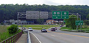
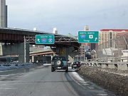
Croton Expressway
Just after Ossining, Route 9A returns and merges with US 9 for approximately 1,500 feet (457 m) as it crosses the mouth of the Croton River
Croton River
The Croton River is a river in southern New York that begins where the East and West Branches of the Croton River meet a little way downstream from the Croton Falls Reservoir...
and becomes the 9.2 miles (14.8 km) Croton Expressway. The only section built of the cancelled Interstate 487
Interstate 487
Interstate 487 was a proposed intrastate Interstate Highway in New York that was to run from The Bronx to Beacon. After much resident opposition, the highway was cancelled in the 1960s.-History:...
, the highway is generally built to interstate standards. 9A leaves the freeway and returns to two lanes, following the parent route's old course, at the first exit, Croton Point Avenue in Croton-on-Hudson
Croton-on-Hudson, New York
Croton-on-Hudson is a village in Westchester County, New York, United States. The population was 8,070 at the 2010 census. It is located in the town of Cortlandt, in New York City's northern suburbs...
, where NY 129
New York State Route 129
New York State Route 129 is a long state highway in the western part of Westchester County, New York. The route begins at NY 9A in the village of Croton on Hudson. NY 129 then travels through the towns of Cortlandt and Yorktown, running along the northern edge of the New Croton...
reaches its western end. Here the modern concrete
Concrete
Concrete is a composite construction material, composed of cement and other cementitious materials such as fly ash and slag cement, aggregate , water and chemical admixtures.The word concrete comes from the Latin word...
ramps of Metro-North's Croton-Harmon station
Croton-Harmon (Metro-North station)
The Croton–Harmon Metro-North Railroad station serves the residents of Croton-on-Hudson, New York via the Hudson Line. It is the main transfer point between the Hudson Line's local and express service, and it is also served by almost all Amtrak trains on the line. Metro-North trains leave for New...
, also served by Amtrak
Amtrak
The National Railroad Passenger Corporation, doing business as Amtrak , is a government-owned corporation that was organized on May 1, 1971, to provide intercity passenger train service in the United States. "Amtrak" is a portmanteau of the words "America" and "track". It is headquartered at Union...
, are prominent to the west as Haverstraw Bay
Haverstraw Bay
Haverstraw Bay, located in New York, is the widest portion of the Hudson River. The width of Haverstraw Bay is approximately 3.4 miles . The length approximately 5 miles from river kilometer 58 at Croton Point to river kilometer 66 at Stony Point...
becomes visible.
Cortlandt (Metro-North station)
The Cortlandt Metro-North Railroad station serves Cortlandt, New York in the hamlet of Crugers via the Hudson Line. Trains leave for New York City every hour on weekdays, and about every 25 minutes during rush hour...
station is visible to the west at one point), rather than the river past the promontory at Buchanan
Buchanan, New York
Buchanan is a village located in the town of Cortlandt in Westchester County, New York. The population was 2,230 as of the 2010 census.The Indian Point nuclear power plant is located in Buchanan.-Geography:Buchanan is located at ....
. NY 9A, as a surface street, ends at its parent at the Welcher Street exit. It continues on a reconstructed, widened section through Peekskill
Peekskill, New York
Peekskill is a city in Westchester County, New York. It is situated on a bay along the east side of the Hudson River, across from Jones Point.This community was known to be an early American industrial center, primarily for its iron plow and stove products...
. Despite recent upgrades to freeway standards, the northern end of the highway still maintains a lower 45 mi/h speed limit.
1 miles (1.6 km) from the freeway's northern terminus, US 202
U.S. Route 202 in New York
U.S. Route 202 is a part of the U.S. Highway System that runs from New Castle, Delaware, to Bangor, Maine. In the U.S. state of New York, US 202 extends from the New Jersey state line near Suffern to the Connecticut state line east of Brewster. While most of US 202 is signed...
and US 6
U.S. Route 6 in New York
U.S. Route 6 is a part of the U.S. Highway System that runs from Bishop, California, to Provincetown, Massachusetts. In New York, US 6 extends from the Pennsylvania state line at Port Jervis to the Connecticut state line east of Brewster...
join the freeway. NY 35 reaches its western terminus at that same junction. The four-lane divided highway's northern terminus is at a stoplight at a three-way intersection with the Bear Mountain State Parkway
Bear Mountain State Parkway
The Bear Mountain State Parkway is a part of the New York State highway system. It was built in 1932 but, unlike most other parkways in Westchester County, New York, it has barely been constructed upon since. It currently stands as an incomplete highway, with a western portion of and an eastern...
. The parkway continues straight from this intersection while 6/9/202 turns left.
Peekskill to Poughkeepsie
Traffic circle
A traffic circle or rotary is a type of circular intersection in which traffic must travel in one direction around a central island. In some countries, traffic entering the circle has the right-of-way and drivers in the circle must yield. In many other countries, traffic entering the circle must...
. While 6 and 202 remain concurrent and exit the circle on its west side, continuing up the river, 9 exits the roundabout on the northeast side. It continues due north as, once again, two-lane Albany Post Road
Albany Post Road
The Albany Post Road was a post road - a road used for mail delivery - in the U.S. state of New York. It connected the cities of New York and Albany along the east side of the Hudson River, a service now performed by US 9.The rough route was as follows:...
. Running inland and mostly free of development behind the Hudson Highlands
Hudson Highlands
The Hudson Highlands are mountains on both sides of the Hudson River in the U.S. state of New York, between Newburgh Bay and Haverstraw Bay, which form the northern region of the New York - New Jersey Highlands....
, it enters Putnam County
Putnam County, New York
Putnam County is a county located in the U.S. state of New York, in the lower Hudson River Valley. Putnam county formed in 1812, when it detached from Dutchess County. , the population was 99,710. It is part of the New York Metropolitan Area. The county seat is the hamlet of Carmel...
. NY 403
New York State Route 403
New York State Route 403 is a short state highway located entirely within Putnam County. It connects NY 9D in Philipstown at its northern/western end to US 9 in Graymoor, where the Appalachian Trail crosses both highways...
reaches its eastern terminus at the same intersection where the Appalachian Trail
Appalachian Trail
The Appalachian National Scenic Trail, generally known as the Appalachian Trail or simply the AT, is a marked hiking trail in the eastern United States extending between Springer Mountain in Georgia and Mount Katahdin in Maine. It is approximately long...
crosses the road. The gas station here has, when in service, long been a favorite stop for thru-hikers. A few miles further to the north, at the Indian Brook Road
Indian Brook Road Historic District
The Indian Brook Road Historic District is located on both sides of that street's intersection with US 9 east of Garrison, New York, United States. Its contain 15 buildings, all but two of which are considered contributing properties to its historic character....
intersection, the highway passes through Nelson's Corner, a rare surviving early 19th-century country hamlet. Old Albany Post Road
Old Albany Post Road
Old Albany Post Road is a dirt road in Philipstown, New York, one of the oldest unpaved roads still in use in the United States. It runs mostly north-south through the southeastern corner of the town, near the Putnam Valley town line...
, a 6.6-mile (10.6 km) remnant of Route 9's original and one of the oldest dirt road
Dirt road
Dirt road is a common term for an unpaved road made from the native material of the land surface through which it passes, known to highway engineers as subgrade material. Dirt roads are suitable for vehicles; a narrower path for pedestrians, animals, and possibly small vehicles would be called a...
s still in use in the country, comes in from the right a mile on. The only other intersection of note in Putnam County is its main east–west state route, NY 301
New York State Route 301
New York State Route 301 is an intra-county state highway stretching across three-quarters of Putnam County, New York, in the United States. The western terminus of NY 301 is at an intersection with NY 9D in Cold Spring. Its eastern terminus is at a junction with NY 52 in...
, which crosses 9 several miles further north, just a mile south of the Dutchess County
Dutchess County, New York
Dutchess County is a county located in the U.S. state of New York, in the state's Mid-Hudson Region of the Hudson Valley. The 2010 census lists the population as 297,488...
line.
US 9 passes Dutchess Mall
Dutchess Mall
Dutchess Mall was an enclosed shopping mall in Fishkill, New York, United States. Currently, the former mall property is the site of a Home Depot, as well as two vacant buildings , with the rest of the property awaiting further redevelopment. Dagar Group manages the shopping center. R.C...
, a dead mall
Dead mall
A dead mall or greyfield is a shopping mall with a high vacancy rate or a low consumer traffic level, or that is dated or deteriorating in some manner. Many malls in the United States are considered "dead" when they have no surviving anchor store or successor that could serve as an entry into or...
, and the historic Van Wyck Homestead
Van Wyck Homestead
The Van Wyck Homestead or Van Wyck-Wharton House [is an early 18th-century Dutch colonial house in the Town of Fishkill, New York, United States of America...
before meeting Interstate 84
Interstate 84 in New York
Interstate 84 is a part of the Interstate Highway System that runs from Dunmore, Pennsylvania, to Sturbridge, Massachusetts, in the Eastern United States. In New York, I-84 extends from the Pennsylvania state line at Port Jervis to the Connecticut state line east of Brewster...
in Fishkill
Fishkill, New York
Fishkill is an upscale village within the much larger town, Town of Fishkill, one of the fastest growing towns in the region, in Dutchess County, New York, USA. The village population was 1,735 at the 2000 census...
. At the interstate exit, the road expands into a four-lane strip similar to the form it takes in Central New Jersey
Central Jersey
Central Jersey is a common designation for a region of the state of New Jersey in the United States of America. Trenton is considered the boundary between designated "North Jersey" and "South Jersey"...
, complete with much commercial development on both sides. It will remain this way to Poughkeepsie. This stretch is an important, if often congested, transportation artery for the county.
Just north of I-84 9 clips off a corner of the village of Fishkill
Fishkill, New York
Fishkill is an upscale village within the much larger town, Town of Fishkill, one of the fastest growing towns in the region, in Dutchess County, New York, USA. The village population was 1,735 at the 2000 census...
, where the intersection with NY 52
New York State Route 52
New York State Route 52 is a long state highway in the southeastern part of New York in the United States. It generally runs from west to east, beginning at the Pennsylvania state line in the Delaware River near Narrowsburg, crossing the Hudson River on the Newburgh-Beacon Bridge, and ending...
creates a heavily congested situation at rush hours since traffic going from southbound 9 to westbound I-84 often uses it as a shortcut. The remaining miles to Wappingers Falls
Wappingers Falls, New York
Wappingers Falls is a village in Dutchess County, New York, United States. The name is derived from the local Wappinger Indians. One half of the village is in the town of Wappinger and the other half is in the town of Poughkeepsie, with Wappinger Creek forming the dividing line between the...
boast many intersections as well, but are not quite as heavy.
In the Town of Poughkeepsie
Poughkeepsie (town), New York
Poughkeepsie is a town in Dutchess County, New York, United States. The population was 42,777 at the 2000 census. The name is derived from the native term, "Uppu-qui-ipis-in," which means "reed-covered hut by the water."...
, just after the northern terminus of NY 9D
New York State Route 9D
New York State Route 9D , also known as the Bear Mountain – Beacon Highway, is a north–south state highway that runs along the eastern shore of the Hudson River in New York in the United States. It starts at the eastern end of the Bear Mountain Bridge at U.S...
, 9 passes another distressed mall, South Hills
South Hills Mall
South Hills Mall was an indoor shopping mall on U.S. 9 in the town of Poughkeepsie, New York. The 675,000 ft² plaza opened in 1974 and included four stores, a small food court, and an eight-screen second-run cinema...
and its healthier, newer counterpart, the Poughkeepsie Galleria
Poughkeepsie Galleria
The Poughkeepsie Galleria is a shopping mall on U.S. 9 in the Town of Poughkeepsie, New York, not far from Wappingers Falls, and is the biggest mall in New York's Hudson Valley region. The mall, which opened in 1987 after much controversy regarding its construction, has an area of with two floors...
. A mile further north, NY 113
New York State Route 113
New York State Route 113 is an east–west state highway located southeast of the city of Poughkeepsie in Dutchess County, New York, United States. The western terminus of the route is at U.S. Route 9 in the town of Poughkeepsie. Its eastern terminus is at NY 376 in the Poughkeepsie...
swings to the west at a cloverleaf interchange
Cloverleaf interchange
A cloverleaf interchange is a two-level interchange in which left turns, reverse direction in left-driving regions, are handled by ramp roads...
near the IBM
IBM
International Business Machines Corporation or IBM is an American multinational technology and consulting corporation headquartered in Armonk, New York, United States. IBM manufactures and sells computer hardware and software, and it offers infrastructure, hosting and consulting services in areas...
plant, once the region's major employer. Entering the city of Poughkeepsie
Poughkeepsie (city), New York
Poughkeepsie is a city in the state of New York, United States, which serves as the county seat of Dutchess County. Poughkeepsie is located in the Hudson River Valley midway between New York City and Albany...
, at Sharon Drive, 9 returns to expressway status once again. 2 miles (3.2 km) north of Sharon, the highway connects to the US 44/NY 55
New York State Route 55
New York State Route 55 is a state highway in southern New York, running from the Pennsylvania state line at the Delaware River in Barryville to the Connecticut state line at Wingdale...
concurrency at an interchange in close proximity to the Mid-Hudson Bridge
Mid-Hudson Bridge
The Mid-Hudson Bridge is a toll suspension bridge which carries US 44 and NY 55 across the Hudson River between Poughkeepsie and Highland in the state of New York. Governor and local resident Franklin D. Roosevelt and his wife Eleanor attended the opening ceremony on August 25, 1930. The bridge...
. This creates some unusual left exits, as traffic from 44/55 east wanting to go north on 9 is routed into a U-turn south of the highway, and likewise northbound drivers on 9 must get turned around to go west over the river. The limited-access highway comes to an end at the intersection with NY 9G
New York State Route 9G
New York State Route 9G is a state highway in the Hudson Valley of New York in the United States. It runs north from U.S. Route 9 at Poughkeepsie, starting out as Violet Avenue, then follows the Hudson River mostly along the eastern side of the US 9 to Rhinebeck, where the two...
near Marist College
Marist College
Marist College is a private liberal arts college on the east bank of the Hudson River near Poughkeepsie, New York. The site was established in 1905 by Marist Brothers, and the college was chartered in 1929...
.
Poughkeepsie to Albany
Hyde Park, New York
Hyde Park is a town located in the northwest part of Dutchess County, New York, United States, just north of the city of Poughkeepsie. The town is most famous for being the hometown of U.S. President Franklin D. Roosevelt....
, passing the Culinary Institute of America
Culinary Institute of America
The Culinary Institute of America is a non-profit culinary college located in Hyde Park USA, founded in 1946. The CIA also has branch campuses in St. Helena, California, and San Antonio, Texas, as well as a campus in Singapore. It is a not-for-profit academic institution of higher learning...
and then the home
Home of Franklin D. Roosevelt National Historic Site
The Home of Franklin D. Roosevelt National Historic Site preserves the Springwood estate in Hyde Park, New York, United States of America. Springwood was the birthplace, lifelong home, and burial place of the 32nd President of the United States, Franklin Delano Roosevelt...
and presidential library
Franklin D. Roosevelt Presidential Library and Museum
The Franklin D. Roosevelt Library in Hyde Park, New York is the first presidential library built in the United States. It was conceived and built under the direction of President Franklin Delano Roosevelt from 1939 to 1940.- History :...
of native Franklin D. Roosevelt
Franklin D. Roosevelt
Franklin Delano Roosevelt , also known by his initials, FDR, was the 32nd President of the United States and a central figure in world events during the mid-20th century, leading the United States during a time of worldwide economic crisis and world war...
. It narrows to two lanes at the built-up area that marks the center of town, then opens up a turn lane for traffic entering the third of the town's tourist attractions, Vanderbilt Mansion National Historic Site
Vanderbilt Mansion National Historic Site
Vanderbilt Mansion National Historic Site, located in Hyde Park, New York, is one of America's premier examples of the country palaces built by wealthy industrialists during the Gilded Age....
.
Past Hyde Park, the road narrows to two lanes again as traffic becomes more local. The area recalls Westchester County with many wooded tracts and stone walls at roadside. Through here it has been running fairly close to the river, but after Staatsburg
Staatsburg, New York
Staatsburg is a hamlet in Dutchess County, New York, United States. The population was 911 at the 2000 census. It is part of the Poughkeepsie–Newburgh–Middletown, NY Metropolitan Statistical Area as well as the larger New York–Newark–Bridgeport, NY-NJ-CT-PA Combined...
the highway begins to veer inland again. The land to the west, between road and river, forms the Hudson River Historic District
Hudson River Historic District
The Hudson River Historic District, also known as Hudson River Heritage Historic District, is the largest such district on the mainland of the contiguous United States...
, the largest in the country and another National Historic Landmark. Route 9 is at least 2 miles (3 km) east of the river when it reaches Rhinebeck
Rhinebeck (village), New York
Rhinebeck is a village located in the Town of Rhinebeck in Dutchess County, New York, USA. The population was 2,657 at the 2010 census. It is part of the Poughkeepsie–Newburgh–Middletown, NY Metropolitan Statistical Area as well as the larger New York–Newark–Bridgeport,...
, the next town along the route, where NY 308
New York State Route 308
New York State Route 308 is a short state highway, in length, located entirely in northern Dutchess County, in the U.S. state of New York. It is a major collector road through mostly rural areas that serves primarily as a shortcut for traffic from the two main north–south routes in the area,...
heads off to the east.
At Weys Corners, the X-shaped intersection north of Rhinebeck, northbound traffic to the river and the Kingston-Rhinecliff Bridge
Kingston-Rhinecliff Bridge
The Kingston–Rhinecliff Bridge is a continuous under-deck truss bridge that carries NY 199 across the Hudson River in New York State north of the City of Kingston and the hamlet of Rhinecliff. It was opened to traffic on February 2, 1957 as a two-lane bridge, although it was not actually...
via NY 199
New York State Route 199
New York State Route 199 is a state highway located in the Hudson Valley of New York in the United States. It extends for from an interchange with U.S. Route 9W and US 209 north of Kingston to an intersection with US 44 and NY 22 southwest of Millerton...
typically bears left onto NY 9G. Southbound traffic, in turn, takes 199 itself to the river when the two meet in Red Hook
Red Hook (village), New York
Red Hook is a village in Dutchess County, New York, USA. The population was 1,961 at the 2010 census. It is part of the Poughkeepsie–Newburgh–Middletown, NY Metropolitan Statistical Area as well as the larger New York–Newark–Bridgeport, NY-NJ-CT-PA Combined Statistical Area...
3 miles (5 km) further ahead. Two blocks north of that junction are the Village Diner
Village Diner
The Village Diner, sometimes called the Halfway Diner or the Historic Village Diner, is located at 39 North Broadway a block north of NY 199 in Red Hook, New York, United States...
, originally named the Halfway Diner since it was roughly halfway along Route 9 from New York City to Albany, and the Elmendorph Inn
Elmendorph Inn
The Elmendorph Inn, often spelled Elmendorf Inn, is the oldest building in the village of Red Hook, New York, United States. It is located at the north corner of North Broadway and Cherry Street, a block north of the junction of Route 9 and NY 199....
, a mid-18th century counterpart to the diner. North of Red Hook, the land around the road begins to open up into farms and fields, offering frequent views of the Catskill Escarpment
Catskill Escarpment
The Catskill Escarpment, often referred to locally as just the Escarpment or the Great Wall of Manitou, and known as the Catskill Front to geologists, is the range forming the northeastern corner of the Catskill Mountains in Greene and Ulster counties in the U.S. state of New York...
across the river. This terrain continues into Columbia County
Columbia County, New York
Columbia County is a county located in the U.S. state of New York. As of the 2010 census, the population was 63,096. The county seat is Hudson. The name comes from the Latin feminine form of the name of Christopher Columbus, which was at the time of the formation of the county a popular proposal...
, which 9 enters 5 miles (8 km) beyond Red Hook.
New York State Route 23
New York State Route 23 is an east–west state highway in the eastern portion New York in the United States. It extends for from an intersection with NY 26 in the Central New York town of Cincinnatus to the Massachusetts state line in the Berkshire Mountains, where it continues east as...
joins 9 as it heads west, which in turn joins NY 9H
New York State Route 9H
New York State Route 9H is a state highway located within Columbia County, New York, United States. It runs from US 9, NY 82, and NY 23 at its southern end in Bell Pond to its northern end in Valatie, also at US 9....
on the northern roadway while NY 82
New York State Route 82
New York State Route 82 is a state highway in the eastern Hudson Valley of New York, United States. It begins at an intersection with NY 52 northeast of the village of Fishkill, bends eastward towards Millbrook, and then returns westward to end at a junction with U.S. Route 9,...
departs to the southeast. 1.5 miles (2.4 km) west, in Greenport
Greenport, Columbia County, New York
Greenport is a town in Columbia County, New York, United States. The population was 4,180 at the 2000 census.The Town of Greenport is on the west border of the county and surrounds the City of Hudson on three sides. US 9 passes through the town....
, 9 turns northward again toward Hudson
Hudson, New York
Hudson is a city located along the west border of Columbia County, New York, United States. The city is named after the adjacent Hudson River and ultimately after the explorer Henry Hudson.Hudson is the county seat of Columbia County...
, the county seat, passing the St. Lawrence
Holcim
Holcim is a Swiss-based global company supplying cement and aggregates . The company also supplies ready-mix concrete and asphalt including associated construction services.-Holcim Group:...
-owned cement
Cement
In the most general sense of the word, a cement is a binder, a substance that sets and hardens independently, and can bind other materials together. The word "cement" traces to the Romans, who used the term opus caementicium to describe masonry resembling modern concrete that was made from crushed...
plant whose expansion was recently blocked by community activists after two contentious years.
On the east fringe of Hudson's historic downtown
Hudson Historic District (New York)
The Hudson Historic District includes most of downtown Hudson, New York, United States, once called "one of the richest dictionaries of architectural history in New York State". It is a area stretching from the city's waterfront on the east bank of the Hudson River to almost its eastern boundary,...
, US 9 intersects the northern terminus of NY 9G and NY 23B
New York State Route 23B
New York State Route 23B is an east–west state highway located in western Columbia County, New York, in the United States. The route is a former section of NY 23 that runs for from NY 9G southwest of Hudson to NY 9H in Claverack...
. Route 23B runs concurrent with 9 for a short distance eastward before splitting at Fairview Avenue, which US 9 follows out of Hudson. A commercial strip with turn lane gives way after 1.75 miles (2.82 km) to the lightly traveled rural two-lane 9 north of Hudson. Near Stockport
Stockport, New York
Stockport is a town in Columbia County, New York, United States. The population was 2,933 at the 2000 census.The Town of Stockport is in the northwest part of the county.- History :The region was settled around 1657....
, Route 9 meets the southern terminus of NY 9J
New York State Route 9J
New York State Route 9J is a state highway in the Hudson Valley region of New York, United States, located in Columbia and Rensselaer counties...
. Farther north, after passing through Kinderhook
Kinderhook Village District
The Kinderhook Village District is located in the central areas of the village of Kinderhook, New York, United States. It is a area covering both developed and undeveloped land centered around US 9....
, home of another U.S. president, Martin Van Buren
Martin Van Buren
Martin Van Buren was the eighth President of the United States . Before his presidency, he was the eighth Vice President and the tenth Secretary of State, under Andrew Jackson ....
, the road passes under NY 9H at a grade-separated
Grade separation
Grade separation is the method of aligning a junction of two or more transport axes at different heights so that they will not disrupt the traffic flow on other transit routes when they cross each other. The composition of such transport axes does not have to be uniform; it can consist of a...
interchange before intersecting the northern terminus of 9H a short distance later outside Valatie
Valatie, New York
Valatie is a village in Columbia County, New York, United States. The population was 1,819 at the 2010 census.The Village of Valatie is in the center of the Town of Kinderhook on US 9.-Geography:Valatie is located at ....
. When a developer wanted to add a fifth leg to this intersection for a new shopping center, the state Department of Transportation
New York State Department of Transportation
The New York State Department of Transportation is responsible for the development and operation of highways, railroads, mass transit systems, ports, waterways and aviation facilities in the U.S...
required the developer to convert the signalized intersection to a roundabout
Roundabout
A roundabout is the name for a road junction in which traffic moves in one direction around a central island. The word dates from the early 20th century. Roundabouts are common in many countries around the world...
, despite heavy local opposition.
Rensselaer County, New York
Rensselaer County is a county in the U.S. state of New York. As of the 2010 census, the population was 159,429. Its name is in honor of the family of Kiliaen van Rensselaer, the original Dutch owner of the land in the area. Its county seat is Troy...
, and will remain so for most of the rest of the way to Albany
Albany, New York
Albany is the capital city of the U.S. state of New York, the seat of Albany County, and the central city of New York's Capital District. Roughly north of New York City, Albany sits on the west bank of the Hudson River, about south of its confluence with the Mohawk River...
, despite limited development and low traffic in some areas. Within a mile of the county line it passes under the New York State Thruway
New York State Thruway
The New York State Thruway is a system of limited-access highways located within the state of New York in the United States. The system, known officially as the Governor Thomas E. Dewey Thruway for former New York Governor Thomas E. Dewey, is operated by the New York State Thruway Authority and...
Berkshire Connector and meets the lone section of Interstate 90
Interstate 90 in New York
Interstate 90 is a part of the Interstate Highway System that runs from Seattle, Washington, to Boston, Massachusetts. In the U.S. state of New York, I-90 extends from the Pennsylvania state line at Ripley to the Massachusetts state line at Canaan...
in New York
New York
New York is a state in the Northeastern region of the United States. It is the nation's third most populous state. New York is bordered by New Jersey and Pennsylvania to the south, and by Connecticut, Massachusetts and Vermont to the east...
not part of the Thruway system, at exit 12 southeast of Castleton-on-Hudson
Castleton-on-Hudson, New York
Castleton-on-Hudson is a village located in the southwestern part of the town of Schodack in Rensselaer County, New York. The population was 1,619 at the 2000 census. The village is southeast of Albany, New York.- History :...
. 4 miles (6 km) north of I-90 and 4 miles (6 km) northwest of Nassau
Nassau (village), New York
Nassau is a village located in the Town of Nassau in Rensselaer County, New York, USA. The population was 1,161 at the 2000 census.The Village of Nassau is in the south part of the county in the Town of Nassau...
, Route 9 veers left to merge with US 20
U.S. Route 20 in New York
U.S. Route 20 is a part of the U.S. Highway System that runs from Newport, Oregon, to Boston, Massachusetts. In the U.S. state of New York, US 20 extends from the Pennsylvania state line at Ripley to the Massachusetts state line in the Berkshire Mountains. US 20 is the longest...
in Schodack Center
Schodack, New York
Schodack is a town in Rensselaer County, New York, United States. The population was 12,536 at the 2000 census. The town name is derived from the native word, Escotak. The town is in the southwestern part of the county. Schodack is southeast of Albany, New York.- History :Prior to the advent of...
, and together they progress northwest toward Albany. Less than 0.5 mile (0.80467 km) from the eastern terminus of the overlap, 9 and 20 intersect NY 150
New York State Route 150
New York State Route 150 is a north–south state highway in Rensselaer County, New York, United States. The southern terminus of the route is at NY 9J in Castleton-on-Hudson...
before connecting to I-90 at exit 11.
As the roadway heads westward, it meets the western (southern for state purposes) terminus of US 4
U.S. Route 4 in New York
U.S. Route 4 is a part of the U.S. Highway System that runs from East Greenbush, New York, to Portsmouth, New Hampshire. In the U.S. state of New York, US 4 extends from an intersection with US 9 and US 20 in East Greenbush to the Vermont state line northeast of Whitehall...
across from a Hannaford
Hannaford Bros. Co.
Hannaford is an American supermarket chain based in Scarborough, Maine. Founded in 1883, Hannaford now operates stores in New England and upstate New York. Formerly known as Shop 'N' Save, Hannaford is owned by the American subsidiary of the Belgian Delhaize Group, Delhaize America, which owns over...
supermarket along the busy commercial strip in East Greenbush. Shortly afterwards the first sign of the state capital, the Erastus Corning Tower
Erastus Corning Tower
The Erastus Corning Tower, also known as the Mayor Erastus Corning 2nd Tower or simply the Corning Tower, is a skyscraper located in downtown Albany, New York. Completed in 1966 and sided with Vermont Pearl marble and glass, the state office building is part of the Empire State Plaza...
, starts becoming visible. At a bluff east of the river, the entire Albany skyline comes into view as the road descends, passing the northern terminus of NY 9J south of Rensselaer
Rensselaer, New York
Rensselaer is a city in Rensselaer County, New York, United States, and is located on the Hudson River directly opposite Albany. As of the 2010 census, the city population was 9,392; in 1920, it was 10,832. The name is from Kiliaen van Rensselaer, the original landowner of the region in New...
. Routes 9 and 20 then cross the Hudson River
Hudson River
The Hudson is a river that flows from north to south through eastern New York. The highest official source is at Lake Tear of the Clouds, on the slopes of Mount Marcy in the Adirondack Mountains. The river itself officially begins in Henderson Lake in Newcomb, New York...
via the Dunn Memorial Bridge
Dunn Memorial Bridge
The Dunn Memorial Bridge, officially known as the Private Parker F. Dunn Memorial Bridge, carries US 9 and US 20 across the Hudson River between Albany, New York and Rensselaer, New York. Completed in 1967 to replace an earlier span bearing the same name, the highway bridge has a steel girder...
into Albany as Corning Tower and the other buildings of Empire State Plaza
Empire State Plaza
The Governor Nelson A. Rockefeller Empire State Plaza is a complex of several state government buildings in downtown Albany, New York....
loom ahead, and the two routes separate, with 20 heading west across the city.
Albany and northward
North of AlbanyAlbany, New York
Albany is the capital city of the U.S. state of New York, the seat of Albany County, and the central city of New York's Capital District. Roughly north of New York City, Albany sits on the west bank of the Hudson River, about south of its confluence with the Mohawk River...
, US 9 starts to pull away from the Hudson corridor, eventually picking up I-87
Interstate 87
Interstate 87 is a Interstate Highway located entirely within New York State in the United States of America. I-87 is the longest intrastate Interstate highway in the Interstate Highway System. Its southern end is at the Bronx approaches of the Robert F. Kennedy Bridge in New York City...
, now the Adirondack Northway.
Albany to Saratoga Springs
After the bridge 9 runs under Interstate 787 for several blocks, then takes an offramp past the Albany Pump House to become Clinton AvenueClinton Avenue Historic District (Albany, New York)
The Clinton Avenue Historic District in Albany, New York, United States, is a area along that street between North Pearl and Quail streets. It also includes some blocks along neighboring streets such as Lark and Lexington....
. Here it intersects the two routes which have paralled 9 up the west side of the Hudson. At Pearl Street and the Palace Theatre
Palace Theatre (Albany, New York)
The Palace Theatre is an entertainment venue, in downtown Albany, New York, located on the corner of Clinton Avenue and North Pearl Street . The 2,844 seat theater is owned by the City of Albany and presents various music, drama, film and comedy performances...
, it crosses NY 32
New York State Route 32
New York State Route 32 is a north–south state highway that extends for through the Hudson Valley and Capital District regions of the U.S. state of New York. It is a two-lane surface road for nearly its entire length, with few divided and no limited-access sections. From Harriman to Albany,...
(North Pearl Street), which continues north, and US 9W
U.S. Route 9W
U.S. Route 9W is a north–south U.S. Highway in the states of New Jersey and New York. It begins on Fletcher Avenue in Fort Lee, New Jersey as it crosses the US 1 & 9, US 46, and the Interstate 95 approaches to the George Washington Bridge, where it heads north up the west...
(Lark Street), which ends at the junction. Route 9 turns north on Henry Johnson Boulevard and widens to cross I-90 again via a flyover
Overpass
An overpass is a bridge, road, railway or similar structure that crosses over another road or railway...
originally built for the canceled Mid-Crosstown Arterial, exiting the city of Albany in the process.
New York State Route 377
New York State Route 377 is a state highway in Albany County, New York, United States. Its southern terminus is at U.S. Route 9 in the city of Albany. After a journey of , it reaches its northern end at an intersection with NY 378 in the suburb of Menands.-Route description:At its...
forks off to the north while Route 9 trends slightly westward. A five-way intersection marks Loudonville
Loudonville, New York
Loudonville is a hamlet in the town of Colonie, in Albany County, New York, United States. Loudonville was a census-designated place in the 1970, 1980, and 1990 US Census, but ceased to be in the 2000 Census.The area is not precisely defined...
. Siena College
Siena College
Siena College is an independent Roman Catholic liberal arts college in Loudonville, in the town of Colonie, New York, United States. Siena is a four-year, coeducational, independent college in the Franciscan tradition, founded by the Franciscan Friars in 1937. It has 3,000 full-time students and...
in Newtonville
Newtonville, New York
Newtonville is a hamlet in the town of Colonie in Albany County, New York, United States. Located along U.S. Route 9, the hamlet is just south of Latham and north of Loudonville. Colonie Town Hall is located in the hamlet of Newtonville.-History:...
is on the east side a mile past the junction, with the headquarters of New York State Police
New York State Police
The New York State Police is the state police force of over 4,600 sworn Troopers for the state of New York. It was established on April 11, 1917 by the New York Legislature, in response to the 1913 murder of a construction foreman named Sam Howell in Westchester County, which at that time did not...
Troop G opposite.
Continuing northward into Latham
Latham, New York
Latham is a hamlet in Albany County, New York, United States. It is located along U.S. Route 9 in the town of Colonie, a dense suburb north of Albany.-History:...
, the highway adds a middle turn lane. NY 155
New York State Route 155
New York State Route 155 is a 17-mile long state highway located entirely within Albany County in the Capital District of New York. The western terminus of the route is at NY 85A in Voorheesville...
intersects as the Northway draws near to the west. Beyond, the road expands to four lanes and commercial property resumes. At the Latham Circle
Latham Circle
The Latham Circle is the intersection of US Route 9 and NY Route 2 within the town of Colonie, New York in Albany County.-Description:The circle takes the name from the hamlet of Latham, of which the circle is close to the exact center...
9 crosses beneath NY 2
New York State Route 2
New York State Route 2 is a state highway in the Capital District of New York, United States. It extends from an interchange with Interstate 87 and NY 7 in the hamlet of Latham within the town of Colonie to the Massachusetts state line, where it continues to Boston as Route 2....
. It is used also to give access to westbound NY 7
New York State Route 7
New York State Route 7 is a 180-mile long New York State Highway that runs from the New York/Pennsylvania border south of Binghamton, New York to the New York/Vermont border east of Hoosick. Most of the road runs along the Susquehanna Valley, closely paralleling Interstate 88 throughout...
. A mile further north, the expressway portion of Route 7 crosses over for eastbound traffic, and then NY 9R
New York State Route 9R
New York State Route 9R is a north–south state highway in northeastern Albany County, New York, in the United States. The route is a eastern loop of U.S. Route 9 , connecting that route to the city of Cohoes to the east...
goes off to the east, to return 2 miles (3 km) further north. At the junction, 9 starts to trend eastward again, away from the Northway, and finally crosses the Mohawk River
Mohawk River
The Mohawk River is a river in the U.S. state of New York. It is the largest tributary of the Hudson River. The Mohawk flows into the Hudson in the Capital District, a few miles north of the city of Albany. The river is named for the Mohawk Nation of the Iroquois Confederacy...
into Saratoga County
Saratoga County, New York
Saratoga County is a county located in the U.S. state of New York. As of the 2010 census, the population was 219,607. It is part of the Albany-Schenectady-Troy Metropolitan Statistical Area. The county seat is Ballston Spa...
via the Crescent Bridge at the northernmost point of Albany County.
A new name, Halfmoon Parkway, comes with the change of county, after the town
Halfmoon, New York
Halfmoon is a town in Saratoga County, New York, United States. The population was 18,474 at the 2000 census. The town is named for the crescent shape of the land between the Hudson River and Mohawk River....
the road runs through. The eastward bent reverses itself as another state route, NY 236
New York State Route 236
New York State Route 236 is a north–south state highway located within the town of Halfmoon in Saratoga County, New York, United States. The highway is little more than a connector linking U.S. Route 9 to NY 146 while bypassing the intersection of the two routes to the south and east...
forks off to the north. By the time 9 reaches the NY 146
New York State Route 146
New York State Route 146 is a state highway in the Capital District of New York in the United States. It extends for from Gallupville at NY 443 to near Mechanicville at U.S. Route 4 and NY 32. NY 146 is a major thoroughfare in the city of Schenectady, just outside of...
junction in Clifton Park
Clifton Park, New York
Clifton Park is a town in Saratoga County, New York, United States. According to the United States Census Bureau, the 2009 population estimate for Clifton Park was 36,469. The name is derived from an early land patent...
, the Northway is right alongside again. The roads continue running parallel courses past Round Lake
Round Lake, New York
Round Lake is a lake and a village in Saratoga County, New York, United States. The population was 604 at the 2000 census. The name is derived from a circular lake adjacent to the village...
as NY 67
New York State Route 67
New York State Route 67 is an east–west state highway in eastern New York in the United States. The western terminus of the route is at an intersection with NY 5 in the town of St. Johnsville...
joins 9 into Malta
Malta, New York
Malta is a town in Saratoga County, New York, United States. The town is in the central part of the county and is south of Saratoga Springs. The population was 13,005 at the 2000 census.- History :The town was first settled before 1865....
, leaving 1.6 miles (2.6 km) later at the center of town for its own exit along the Northway. Another 1.5 miles (2.4 km) to the north, another lettered subroute of US 9, NY 9P
New York State Route 9P
New York State Route 9P is a state highway in central Saratoga County, New York, United States. It is an alternate route off U.S. Route 9 between Malta and Saratoga Springs that connects US 9 to the eastern shore of Saratoga Lake. NY 9P meets NY 423 in the town of...
, leaves east for Saratoga Lake.
Saratoga Springs, New York
Saratoga Springs, also known as simply Saratoga, is a city in Saratoga County, New York, United States. The population was 26,586 at the 2010 census. The name reflects the presence of mineral springs in the area. While the word "Saratoga" is known to be a corruption of a Native American name, ...
. The resort town's historic downtown
Broadway Historic District (Saratoga Springs, New York)
The Broadway Historic District is located along that street in Saratoga Springs, New York, United States. It has a twofold character. The southern section is the commercial core of the city, with many of its important public and private buildings, most intact from the its peak days as a resort town...
is 4 miles (6 km) ahead, past Saratoga Spa State Park
Saratoga Spa State Park
Saratoga Spa State Park is a state park located in Saratoga County, New York in the USA. The park is in the City of Saratoga Springs, near US 9 and NY 50.-History:...
and Congress Park
Canfield Casino and Congress Park
Canfield Casino and Congress Park is a site in Saratoga Springs, New York, United States. It was the site of the former Congress Spring Bottling Plant and the former Congress Hall, a large resort hotel, which together brought Saratoga Springs international fame as a health spa and gambling site...
. Here 9, as South Broadway, begins a concurrency with NY 50
New York State Route 50
New York State Route 50 is a state highway in the Capital District of New York in the United States. The southern terminus of the route is at an intersection with NY 5 in Scotia...
and, later, briefly, with NY 29
New York State Route 29
New York State Route 29 is a state highway extending for across the eastern portion of the U.S. state of New York. The western terminus of the route is at NY 28 and NY 169 in Middleville, Herkimer County. The eastern terminus of the route is at NY 22 just south of Salem,...
. 9P completes its loop here, and another lettered route, NY 9N
New York State Route 9N
New York State Route 9N is a north–south state highway in northeastern New York, United States. It extends from an intersection with U.S. Route 9 , NY 29, and NY 50 in the city of Saratoga Springs to a junction with US 9 and NY 22 in the Clinton County village of...
, the longest letter-suffixed route in the state, begins at the post office
U.S. Post Office (Saratoga Springs, New York)
The U.S. Post Office in Saratoga Springs, New York, United States, is located at the junction of Broadway and Church Street in the center of the city. It is an early 20th-century brick structure in the Classical Revival architectural style, designed by James Knox Taylor, supervising architect for...
. Tacking eastward out of town, 9 and 50 follow Van Dam Street until 9 returns to a northerly course on Marion Avenue, which becomes Maple Avenue at the city limit.
Saratoga Springs to Lake George
Once past the sleeve of development around the highway north of the city, 9 is out of the Albany metropolitan areaCapital District
New York's Capital District, also known as the Capital Region, is a region in upstate New York that generally refers to the four counties surrounding Albany, the capital of the state: Albany County, Schenectady County, Rensselaer County, and Saratoga County...
as it gets less developed through Wilton
Wilton, New York
Wilton is a town in Saratoga County, New York, United States. The population was 12,511 at the 2000 census.The Town of Wilton is in the northeastern part of the county, northeast of Saratoga Springs, which it borders.-History:...
and Moreau
Moreau, New York
Moreau is a town in Saratoga County, New York, United States. The population was 13,826 at the 2000 census. The town is located in the northeast part of the county, north of Saratoga Springs. Moreau is named after Jean Victor Moreau, a French general, who visited the area just before the town was...
. The Palmerstown Range begins to rise on one side, anticipating the mountainous country to come. From the hamlet of Kings Station onward, what is now signed as Saratoga Road follows a straight northeast course for 10 miles (16 km) through more wooded countryside to the entrance to Moreau Lake State Park
Moreau Lake State Park
Moreau Lake State Park is a state park located in Saratoga County, New York in the USA. Located in the southwest part of Moreau, New York on US 9 off Interstate 87, the 4,100 acre park offers snowshoeing and cross-country skiing in winter, swimming in Moreau Lake, paddling on the Hudson River,...
. A mile further on, 9 again intersects the Northway at exit 17.
Another 1.5 miles (2.4 km) brings it to the western end of NY 197
New York State Route 197
New York State Route 197 is an east–west state highway in eastern New York, United States. It runs from U.S. Route 9 in the Saratoga County town of Moreau east to NY 40 in Argyle. NY 197 has a short overlap with U.S...
(Reynolds Road). US 9 continues straight ahead for the next 3 miles (5 km) into the village of South Glens Falls
South Glens Falls, New York
South Glens Falls is a village in Saratoga County, New York, United States. The population was 3,368 at the 2000 census. The village is in the northern part of the Town of Moreau, south of the City of Glens Falls....
, where NY 32 (Gansevoort Road), comes in at an oblique angle from the south and merges with 9 to cross the Hudson via the Cooper's Cave Bridge for the last time, leave Saratoga County and enter the Warren County
Warren County, New York
Warren County is a county in the U.S. state of New York. It is part of the Glens Falls, New York, Metropolitan Statistical Area. As of the 2010 census, the population was 65,707. It is named in honor of General Joseph Warren, an American Revolutionary War hero of the Battle of Bunker Hill...
city of Glens Falls
Glens Falls, New York
Glens Falls is a city in Warren County, New York, United States. Glens Falls Metropolitan Statistical Area. The population was 14,700 at the 2010 census...
.
The two routes follow Glen Street to a five-way intersection in the center of town, where 32 leaves to the right via Warren Street and NY 9L
New York State Route 9L
New York State Route 9L is a state highway in Warren County, New York, in the United States. The road is long and is a suffixed highway of U.S. Route 9 . NY 9L goes through three municipalities in Warren County: the city of Glens Falls, the town of Queensbury and the town of Lake...
takes Ridge Street due north. 9 continues via Glen to the northwest, becoming Upper Glen Street at the city limit. NY 254
New York State Route 254
New York State Route 254 is a state highway that extends for through Warren and Washington Counties in the Capital District of New York, United States...
(Aviation Road) comes in from its nearby western terminus at the Northway. The highway remains heavily developed for the next 3 miles (5 km) to a junction with another route beginning at I-87, NY 149
New York State Route 149
New York State Route 149 is an east–west state highway that runs for through the Capital District of New York in the United States. It begins at exit 20 on the Adirondack Northway in the Warren County town of Queensbury and intersects U.S...
. It joins with US 9 briefly before leaving to the east north of the Adirondack-Lake George Outlet Mall. Many vehicles make that turn, as 149 is the best route from the Northway into southern Vermont
Vermont
Vermont is a state in the New England region of the northeastern United States of America. The state ranks 43rd in land area, , and 45th in total area. Its population according to the 2010 census, 630,337, is the second smallest in the country, larger only than Wyoming. It is the only New England...
, 30 miles (48 km) to the east.
Route 9 continues to parallel the interstate. At the Queensbury
Queensbury, New York
Queensbury is a town in and the county seat of Warren County, New York, United States. The town is located in the southeastern part of the county. The population was 25,441 at the 2000 census. The town is named in honor of Queen Charlotte, the consort of George III of Great Britain and Ireland. It...
-Lake George
Lake George (town), New York
Lake George is a town in Warren County, New York, USA. The population was 3,578 at the 2000 census. The town is named after the lake, Lake George. Within the town is a village also named Lake George. The town is part of the Glens Falls Metropolitan Statistical Area.- History :The lake was...
town line, a massive wooden shingle lets drivers know they have crossed the Blue Line
Blue Line (New York State)
The Blue Line is the term used in New York state for the boundaries of the Adirondack and Catskill parks, within which can be found the state's Forest Preserve...
into the Adirondack Park. The route straightens out for the next 2.5 miles (4 km) into the village of Lake George
Lake George (village), New York
The Village of Lake George is a village within the town of Lake George in Warren County, New York, United States. The population was 985 at the 2000 census. It is part of the Glens Falls Metropolitan Statistical Area...
, a popular tourist destination.
It takes the name Canada Street, and NY 9N comes in from the west to run concurrently with. The two routes widen to a busy four-lane road past shops catering to a busy tourist trade. Shortly thereafter, NY 9L loops back to the parent route, after having followed the east shore of the lake
Lake George (New York)
Lake George, nicknamed the Queen of American Lakes, is a long, narrow oligotrophic lake draining northwards into Lake Champlain and the St. Lawrence River Drainage basin located at the southeast base of the Adirondack Mountains in northern New York, U.S.A.. It lies within the upper region of the...
that gives the village its name. At the northern end of the village of Lake George, 9N splits via Lake Shore Drive to follow the western shore, and 9 itself takes a northwesterly turn to remain parallel with the Northway.
Adirondack Park
The nature of the Adirondack Park becomes apparent once Lake George is past. The next 90 miles (145 km) of Route 9 run through the eastern section of the largest protected areaProtected area
Protected areas are locations which receive protection because of their recognised natural, ecological and/or cultural values. There are several kinds of protected areas, which vary by level of protection depending on the enabling laws of each country or the regulations of the international...
east of the Mississippi
Mississippi River
The Mississippi River is the largest river system in North America. Flowing entirely in the United States, this river rises in western Minnesota and meanders slowly southwards for to the Mississippi River Delta at the Gulf of Mexico. With its many tributaries, the Mississippi's watershed drains...
, 6100000 acres (24,685.8 km²) with vast tracts of Forest Preserve
Forest Preserve (New York)
New York's Forest Preserve is all the land owned by the state within the Adirondack and Catskill parks, managed by its Department of Environmental Conservation. These properties are required to be kept "forever wild" by Article 14 of the state constitution, and thus enjoy the highest degree of...
kept "forever wild" per the state constitution. Accordingly, 9 remains a two-lane rural road, often very close to the Northway, throughout the park. Development, traffic and population are minimal, the surrounding land is heavily wooded and the two roads cover very long, lonely distances between very small, solitary towns.
After Lake George, there is another exit with the Northway, to ease access to the village by southbound traffic. US 9 remains very close to the Northway on its east side, resulting in another exit 4 miles (6 km) north. This serves Warrensburg
Warrensburg (CDP), New York
Warrensburg is a census-designated place in Warren County, New York, United States. The population was 3,208 at the 2000 census. It is part of the Glens Falls Metropolitan Statistical Area....
, where NY 418
New York State Route 418
New York State Route 418 is a state highway located entirely within the Adirondack Park in Warren County, New York, United States. The route begins just west of the hamlet of Thurman Station, where Athol Road changes designations from County Route 4 to NY 418...
reaches its eastern terminus. The highway begins to move further away from the interstate and 3 miles (5 km) further, NY 28
New York State Route 28
New York State Route 28 is a state highway extending for in the shape of a "C" between the Hudson Valley city of Kingston and southern Warren County in the U.S. state of New York. Along the way, it intersects several major routes, including Interstate 88 , U.S. Route 20 , and the...
concludes its long bow-shaped route at a junction with 9.
Chestertown, New York
Chestertown is a hamlet in Warren County, New York, United States, in the Adirondack Mountains, in the Town of Chester. The population was 2,187 at the 2000 census. The community is located by the junction of Route 8 and U.S. Route 9....
, Route 9 meets and joins NY 8
New York State Route 8
New York State Route 8 is a state highway in the central part of New York in the United States. It runs in a southwest-to-northeast direction from the Southern Tier to the northern part of Lake George. The southern terminus of the route is at an interchange with NY 17 in the town of...
, which carries it due west almost 4 miles (6 km) to Loon Lake
Loon Lake (Warren County, New York)
Loon Lake is a wishbone-shaped body of water in Warren County, New York. It is located within the Town of Chester, which maintains the beach. Fishing and boating are popular activities. Common fish species within the lake include Pumpkinseed sunfish, Rock bass, Perch, Smallmouth bass, Largemouth...
. After crossing over a southwestern bay of the lake, 9 turns right and is once again on its own, trending northeast alongside the lake's western shore to eventually reach the Northway again in 4 miles (6 km). This exit serves only northbound traffic. A mile later, there is access for the other direction.
The road begins to run along the west shore of Schroon Lake, in the process crossing into Essex County
Essex County, New York
Essex County is a county located in the U.S. state of New York. As of the 2010 census, the population was 39,370. Its name is from the English county of Essex. Its county seat is Elizabethtown...
. Shortly after the county line, an access road leads to I-87 again. It is 7 miles (11 km) from here, past the hamlet of Schroon Lake at the water's northern tip, that 9 intersects NY 74
New York State Route 74
New York State Route 74 and Vermont Route 74 are adjoining state highways in the northeastern United States, connected by one of the last remaining cable ferries in North America. Together they extend for through Essex County, New York, and Addison County, Vermont...
, like 254 and 149 fresh off its western terminus at the Northway. Signs at this junction use Ticonderoga
Ticonderoga, New York
Ticonderoga is a town in Essex County, New York, USA. The population was 5,167 at the 2000 census. The name comes from the Mohawk tekontaró:ken, meaning "it is at the junction of two waterways"....
, 17 miles (27 km) to the east, as a control city
Control city
A control city is a city or locality posted on a traffic sign indicating forward destinations on a certain route. These destinations aid motorists using the highway system to reach destinations along the various routes...
, an indication of how sparsely populated the park is.
9 remains close to the interstate for the next 16 miles (26 km) into the town of North Hudson
North Hudson, New York
North Hudson is a town in Essex County, New York, United States. The population was 266 at the 2000 census. The town derives its name by being by the north end of the Hudson River....
, where Boreas Road provides access to the Dix Mountain Wilderness Area
Dix Mountain Wilderness Area
The Dix Mountain Wilderness Area, an Adirondack Park unit of New York's Forest Preserve, is located in the towns of Elizabethtown, Keene and North Hudson, Essex County...
the southernmost in the Adirondack High Peaks region. The highway again crosses the interstate to connect I-87 to the western terminus of NY 73
New York State Route 73
New York State Route 73 is a state highway located entirely within Essex County, New York, United States. The highway begins at an intersection with NY 86 in the village of Lake Placid and ends at a junction with U.S. Route 9 north of the hamlet of Underwood in the extreme...
, the well-traveled scenic route to Keene Valley and Lake Placid
Lake Placid, New York
Lake Placid is a village in the Adirondack Mountains in Essex County, New York, United States. As of the 2000 census, the village had a population of 2,638....
. At this ornate junction, 9 is at 1,155 feet (340 m) above sea level, the highest elevation it reaches along its entire length.
The right turn takes it again to the northeast past Rocky Peak Ridge
Rocky Peak Ridge
Rocky Peak Ridge is the twentieth highest peak in the High Peaks Region of the Adirondack Park of New York, USA. The name of the mountain is due to its geology, a rocky ridge to the east of the better known Giant Mountain...
and the Giant Mountain Wilderness Area
Giant Mountain Wilderness Area
The Giant Mountain Wilderness Area, an Adirondack Park unit of New York's Forest Preserve, lies in Essex County, New York, in the towns of Elizabethtown and Keene. It is roughly bounded by NY 9N on the north, NY 73 on the west and south and US 9 on the east...
, to the hamlet of New Russia. This 10 miles (16 km) stretch brings the highway to Elizabethtown
Elizabethtown (hamlet), New York
Elizabethtown is a hamlet in the town of Elizabethtown in Essex County, New York, United States. Many locals in the town, as well as those who surround the area call Elizabethtown, E-Town....
, the unincorporated county seat
County seat
A county seat is an administrative center, or seat of government, for a county or civil parish. The term is primarily used in the United States....
and the first settlement 9 has passed through since Warrensburg. NY 9N comes through town from the west; it and US 9 briefly overlap.
While the land remains mostly forested as the road continues its northeast course from Elizabethtown, it begins to descend somewhat as the valley of Lake Champlain
Lake Champlain
Lake Champlain is a natural, freshwater lake in North America, located mainly within the borders of the United States but partially situated across the Canada—United States border in the Canadian province of Quebec.The New York portion of the Champlain Valley includes the eastern portions of...
draws near. 9 eventually draws close to the Northway again at Poke-O-Moonshine Mountain, the Adirondacks' most popular climbing
Climbing
Climbing is the activity of using one's hands and feet to ascend a steep object. It is done both for recreation and professionally, as part of activities such as maintenance of a structure, or military operations.Climbing activities include:* Bouldering: Ascending boulders or small...
spot. In Chesterfield
Chesterfield, New York
Chesterfield is a town in Essex County, New York, United States. The population was 2,409 at the 2000 census. The name possibly is from a location in New England....
, 18 miles (29 km) without a major highway junction are ended when NY 22
New York State Route 22
New York State Route 22 is a north–south state highway in eastern New York in the United States. It runs parallel to the state's eastern edge from the outskirts of New York City to a short distance south of the Canadian border. At , it is the state's longest north–south route and...
joins 9 after its exit, the first pairing of two highways that begin their journey upstate in New York City.
The two routes enter Keeseville
Keeseville, New York
Keeseville is a village in both Clinton County, New York and in Essex County, New York in the United States. The population was 1,815 at the 2010 census. The village is named after the Keese family....
, where in mid-village they cross the Ausable River and enter Clinton County
Clinton County, New York
Clinton County is a county located in the U.S. state of New York. As of the 2010 census, the population was 82,128. Its name is in honor of the first Governor of New York as a state, George Clinton. Its county seat is Plattsburgh.-History:...
. NY 9N reappears here, reaching its northern terminus. North of the village, the two routes split again and exchange the roles they had been playing for their entire northward journey. 9 takes the eastward fork to the lake, running close to the state's edge; while 22 will run inland from here to the border.
After Keeseville, 9 follows AuSable Chasm down to the lake shore. It crosses the Ausable and briefly re-enters Essex County long enough for the short NY 373
New York State Route 373
New York State Route 373 is a short state highway in Essex County, New York, within Adirondack State Park. It begins at U.S. Route 9 and proceeds eastward, ending at a ferry landing on Lake Champlain. It intersects two county routes, several local roads, and a reference...
to provide access to the Port Kent-Burlington Ferry. A third and final crossing takes it out of the Adirondack Park.
Lake Champlain, Plattsburgh and Canada
After 9 passes Ausable Marsh Wildlife Management Area and NY 442New York State Route 442
New York State Route 442 is a state highway located within the town of Peru in Clinton County, New York, in the United States. It is an east–west highway that connects the hamlet of Peru with the Adirondack Northway . The western terminus of the route is at an intersection with...
comes in from the east at the small hamlet of Peru
Peru, New York
Peru is a town in Clinton County in the U.S. state of New York. The population was 6,998 at the 2010 census. The town was named Peru because its mountainous nature suggested that country....
, 9 heads down to the shore of the lake itself, which it will stay close to all the way into Plattsburgh as Lakes to Locks Passage. On clear days it is possible to see Burlington
Burlington, Vermont
Burlington is the largest city in the U.S. state of Vermont and the shire town of Chittenden County. Burlington lies south of the U.S.-Canadian border and some south of Montreal....
across the water. Ahead lies Valcour Island
Valcour Island
Valcour Island is an island in Lake Champlain in Clinton County, New York, USA. The island is mostly in the Town of Peru and partly in the Town of Plattsburgh, southeast of the City of Plattsburgh....
. In the narrow, rocky strait between it and the shore, Benedict Arnold
Benedict Arnold
Benedict Arnold V was a general during the American Revolutionary War. He began the war in the Continental Army but later defected to the British Army. While a general on the American side, he obtained command of the fort at West Point, New York, and plotted to surrender it to the British forces...
's hastily built fleet held off the British
British Army
The British Army is the land warfare branch of Her Majesty's Armed Forces in the United Kingdom. It came into being with the unification of the Kingdom of England and Scotland into the Kingdom of Great Britain in 1707. The new British Army incorporated Regiments that had already existed in England...
on October 11, 1776 in the Battle of Valcour Island
Battle of Valcour Island
The naval Battle of Valcour Island, also known as the Battle of Valcour Bay, took place on October 11, 1776, on Lake Champlain. The main action took place in Valcour Bay, a narrow strait between the New York mainland and Valcour Island...
in what is considered the first battle of U.S. naval history
History of the United States Navy
The history of the United States Navy divides into two major periods: the "Old Navy", a small but respected force of sailing ships that was also notable for innovation in the use of ironclads during the American Civil War, and the "New Navy", the result of a modernization effort that began in the...
. More recent military history is apparent shortly thereafter when 9 passes now-closed Plattsburgh Air Force Base
Plattsburgh Air Force Base
Plattsburgh Air Force Base is a former United States Air Force Strategic Air Command base covering 3,447 acres in the extreme northeast corner of New York, 20 miles south of the Canadian border...
, a pillar of the regional economy Plattsburgh has struggled to replace.
Plattsburgh (city), New York
Plattsburgh is a city in and county seat of Clinton County, New York, United States. The population was 19,989 at the 2010 census. The population of the unincorporated areas within the Town of Plattsburgh was 11,870 as of the 2010 census; making the population for the immediate, urban Plattsburgh,...
, it becomes first U.S. Avenue, then Peru Street when it passes the Old Catholic Cemetery. The Saranac River
Saranac River
Saranac River is an river in the U.S. state of New York. In its upper reaches is a region of mostly flat water and lakes. The river has more than three dozen source lakes and ponds north of Upper Saranac Lake; the highest is Mountain Pond on Long Pond Mountain...
draws alongside twice before 9 takes a left turn at Bridge Street and crosses it. Just past the bridge, the highway turns left again onto City Hall Place at the center of town. Route 9 passes in front of the City Hall
City Hall (Plattsburgh, New York)
Plattsburgh City Hall is an historic government building located at City Hall Place in Plattsburgh, New York. Designed by architect John Russell Pope, it was constructed in 1917 in the classical revival style....
designed by John Russell Pope
John Russell Pope
John Russell Pope was an architect most known for his designs of the National Archives and Records Administration building , the Jefferson Memorial and the West Building of the National Gallery of Art in Washington, DC.-Biography:Pope was born in New York in 1874, the son of a successful...
, also the builder of the Jefferson Memorial
Jefferson Memorial
The Thomas Jefferson Memorial is a presidential memorial in Washington, D.C. that is dedicated to Thomas Jefferson, an American Founding Father and the third President of the United States....
in Washington. Two more quick lefts follow past the large obelisk
Obelisk
An obelisk is a tall, four-sided, narrow tapering monument which ends in a pyramid-like shape at the top, and is said to resemble a petrified ray of the sun-disk. A pair of obelisks usually stood in front of a pylon...
of Riverside Park, onto Miller and Cornelia streets, then 9 turns right at the eastern terminus of the lengthy NY 3
New York State Route 3
New York State Route 3 is a major east–west state highway in New York, United States, that connects central New York to the North Country region near the Canadian border via Adirondack Park. The route extends for between its western terminus at an intersection with NY 104A in the Cayuga...
to follow Margaret Street north and out of the city.
It bends northeast to return to the lake shore shortly after the city limit, following alongside Cumberland Bay
Cumberland Bay
Cumberland Bay, wide at its entrance between Larsen and Barff Points, which separates into two extensive arms that recede inland along the northern coast of South Georgia. Discovered and named in 1775 by a British expedition under James Cook....
. At the Dead Creek crossing, 9 widens to four lanes for the first time since the Albany area to handle the heavy traffic at the junction with NY 314
New York State Route 314
New York State Route 314 and Vermont Route 314 are a pair of like-numbered state highways in New York and Vermont, United States, that are connected by way of the Plattsburgh – Grand Isle Ferry across Lake Champlain...
, another ferry connector, just southeast of the Northway. 2 miles (3 km) north of the junction, after North Country Shopping Center, the highway returns to two lanes and the name Lakes to Locks Passage as it overlooks Woodruff Pond and Treadwell Bay. I-87 is visible a thousand feet (305 m) to the east across the many open fields as the two roads parallel each others turns closely.
Another short route, NY 456
New York State Route 456
New York State Route 456 is a short state highway located entirely within the town of Beekmantown in Clinton County, New York, in the United States...
, comes in from the west and terminates at 9 shortly after the right turn for Point Au Roche State Park
Point Au Roche State Park
Point Au Roche State Park is a state park in Clinton County in the State of New York in the USA. The park is in the east part of the Town of Beekmantown on the shore of Lake Champlain. It was started by former Town Supervisor Florence Corron with a grant.It has a playground,biking paths, walking...
. Continuing northward, the road deviates to the east slightly in the Town of Chazy
Chazy, New York
Chazy is a town in northeastern Clinton County, New York, in the United States. The population was 4,284 at the 2010 census. The closest city is Plattsburgh, to the south. Chazy is from Canada. The zip code is 12921 and it is in area code 518.- History:...
, but returns to its previous track by the interstate at the Little Chazy River bridge. Shortly afterwards, NY 191
New York State Route 191
New York State Route 191 is a short county-maintained state highway located north of Adirondack Park in Clinton County, New York, United States. The route is co-designated by the county highway department as County Route 23 and heads from an intersection with NY 22 in the hamlet of...
(Miner Farm Road) comes in from the west.
Route 9 runs straight, no longer taking another name, and due north 3 miles (5 km) to the next major intersection, NY 9B
New York State Route 9B
New York State Route 9B is a state highway located within Clinton County, New York, in the United States. The route serves as a connector between its parent route, U.S. Route 9 , in the town of Champlain and US 11 in the village of Rouses Point...
(Lavalley Road), its last subroute. 9B does not terminate but instead runs to the lakeshore and eventually north to Rouses Point
Rouses Point, New York
Rouses Point is a village in Clinton County, New York, United States, along the 45th parallel. The population was 2,209 at the 2010 census. The village is named after Jacques Rouse, an early settler....
. A bend slightly to the west, closer to the Northway, brings the next 3 miles (5 km) stretch to 9's last major intersection, US 11
U.S. Route 11
U.S. Route 11 is a north–south United States highway extending 1,645 miles across the eastern United States. The southern terminus of the route is at U.S. Route 90 in the Bayou Sauvage National Wildlife Refuge in eastern New Orleans, Louisiana. The northern terminus is at the United...
, just south of Champlain
Champlain (village), New York
Champlain is a village in Clinton County, New York, USA. The population was 1,101 at the 2010 census. The village is named after nearby Lake Champlain.The Village of Champlain in located in the Town of Champlain and is north of Plattsburgh.-History:...
.
US 9 winds through the quiet border village as its Main Street, turning west-northwest near Champlain's northern boundary to make its last water crossing over the Chazy River
Chazy River
Chazy River is the name of two tributaries of Lake Champlain in Clinton County, New York in the United States.The more northerly river is the Great Chazy River, which empties into Lake Champlain at King Bay in the Town of Champlain....
. 9, still known as Main Street, heads northwest towards the Northway to follow it for the last 0.5 mile (0.80467 km) passing a few customs brokerages
Customs broking
Customs brokerage is a profession that involves the 'clearing' of goods through customs barriers for importers and exporters...
towards its official end at the onramp to the last exit. Traffic to Canada must get on I-87 here.
The roadway continues as the East Service Road, unsigned NY 971B, for another 0.5 mile (0.80467 km). This was the former route of US 9 to the border prior to the construction of the Northway. It is devoid of any development save some long vacant and abandoned lots, finally ending in a parking lot
Parking lot
A parking lot , also known as car lot, is a cleared area that is intended for parking vehicles. Usually, the term refers to a dedicated area that has been provided with a durable or semi-durable surface....
400 feet (121.9 m) south of the border from which the Canadian customs station
Blackpool Border Crossing
The Blackpool Border Crossing is the name for a land border crossing between the United States and Canada, commonly known as the International Boundary....
at the south end of Autoroute 15
Quebec Autoroute 15
Autoroute 15 is a highway in western Quebec, Canada...
is visible.
Origins
Much of what is now US 9 in New YorkNew York
New York is a state in the Northeastern region of the United States. It is the nation's third most populous state. New York is bordered by New Jersey and Pennsylvania to the south, and by Connecticut, Massachusetts and Vermont to the east...
was assigned an unsigned legislative route
Legislative route
In United States, a legislative route or legislative highway is a highway defined by laws passed in a state legislature. The numbering of such highways may or may not correspond to the numbers familiar to the public as part of the state, U.S. highway, and Interstate highway systems...
designation by the New York State Legislature in 1908. Route 2 joined modern US 9 at Archville (north of Tarrytown
Tarrytown, New York
Tarrytown is a village in the town of Greenburgh in Westchester County, New York, United States. It is located on the eastern bank of the Hudson River, about north of midtown Manhattan in New York City, and is served by a stop on the Metro-North Hudson Line...
) and followed it north to Croton-on-Hudson
Croton-on-Hudson, New York
Croton-on-Hudson is a village in Westchester County, New York, United States. The population was 8,070 at the 2010 census. It is located in the town of Cortlandt, in New York City's northern suburbs...
, where it turned off to the northeast on modern NY 129
New York State Route 129
New York State Route 129 is a long state highway in the western part of Westchester County, New York. The route begins at NY 9A in the village of Croton on Hudson. NY 129 then travels through the towns of Cortlandt and Yorktown, running along the northern edge of the New Croton...
. The legislative route rejoined what is now US 9 at Peekskill
Peekskill, New York
Peekskill is a city in Westchester County, New York. It is situated on a bay along the east side of the Hudson River, across from Jones Point.This community was known to be an early American industrial center, primarily for its iron plow and stove products...
and remained on it to Valatie
Valatie, New York
Valatie is a village in Columbia County, New York, United States. The population was 1,819 at the 2010 census.The Village of Valatie is in the center of the Town of Kinderhook on US 9.-Geography:Valatie is located at ....
, where it met Route 1. Route 2 ended here while Route 1 continued north to Albany
Albany, New York
Albany is the capital city of the U.S. state of New York, the seat of Albany County, and the central city of New York's Capital District. Roughly north of New York City, Albany sits on the west bank of the Hudson River, about south of its confluence with the Mohawk River...
on current US 9. From Albany to Clifton Park
Clifton Park, New York
Clifton Park is a town in Saratoga County, New York, United States. According to the United States Census Bureau, the 2009 population estimate for Clifton Park was 36,469. The name is derived from an early land patent...
and from South Glens Falls
South Glens Falls, New York
South Glens Falls is a village in Saratoga County, New York, United States. The population was 3,368 at the 2000 census. The village is in the northern part of the Town of Moreau, south of the City of Glens Falls....
to Riparius, modern US 9 was part of Route 25. At Riparius, Route 25 met Route 22, which utilized what is now US 9 from Riparius to Elizabethtown
Elizabethtown (hamlet), New York
Elizabethtown is a hamlet in the town of Elizabethtown in Essex County, New York, United States. Many locals in the town, as well as those who surround the area call Elizabethtown, E-Town....
and from Keeseville
Keeseville, New York
Keeseville is a village in both Clinton County, New York and in Essex County, New York in the United States. The population was 1,815 at the 2010 census. The village is named after the Keese family....
to the town of Champlain
Champlain (town), New York
Champlain is a town in Clinton County, New York, United States. The population was 5,754 at the 2010 census. The town is named after Lake Champlain....
. While modern US 9 travels directly from Elizabethtown to Keeseville and bypasses Rouses Point
Rouses Point, New York
Rouses Point is a village in Clinton County, New York, United States, along the 45th parallel. The population was 2,209 at the 2010 census. The village is named after Jacques Rouse, an early settler....
to the west, Route 25 used current NY 9N
New York State Route 9N
New York State Route 9N is a north–south state highway in northeastern New York, United States. It extends from an intersection with U.S. Route 9 , NY 29, and NY 50 in the city of Saratoga Springs to a junction with US 9 and NY 22 in the Clinton County village of...
between Elizabethtown and Keeseville and served Rouses Point via modern NY 9B
New York State Route 9B
New York State Route 9B is a state highway located within Clinton County, New York, in the United States. The route serves as a connector between its parent route, U.S. Route 9 , in the town of Champlain and US 11 in the village of Rouses Point...
. Routes 2 and 25 were realigned slightly on March 1, 1921, to utilize the modern US 9 corridor from Croton-on-Hudson to Peekskill and from Saratoga Springs
Saratoga Springs, New York
Saratoga Springs, also known as simply Saratoga, is a city in Saratoga County, New York, United States. The population was 26,586 at the 2010 census. The name reflects the presence of mineral springs in the area. While the word "Saratoga" is known to be a corruption of a Native American name, ...
to South Glens Falls, respectively.
When the first set of posted routes in New York were assigned in 1924, the general routing of modern US 9 was designated as NY 6, which went from the New York City
New York City
New York is the most populous city in the United States and the center of the New York Metropolitan Area, one of the most populous metropolitan areas in the world. New York exerts a significant impact upon global commerce, finance, media, art, fashion, research, technology, education, and...
line at Yonkers
Yonkers, New York
Yonkers is the fourth most populous city in the state of New York , and the most populous city in Westchester County, with a population of 195,976...
north to the Canadian border near Rouses Point
Rouses Point, New York
Rouses Point is a village in Clinton County, New York, United States, along the 45th parallel. The population was 2,209 at the 2010 census. The village is named after Jacques Rouse, an early settler....
. From New York City, NY 6 followed current US 9 north to Tarrytown, where it joined legislative Route 2 and continued north through Valatie to Albany via legislative Routes 1 and 2. North of Albany, NY 6 served Cohoes
Cohoes, New York
Cohoes is an incorporated city located at the northeast corner of Albany County in the US state of New York. It is called the "Spindle City" because of the importance of textile production to its growth. As of the 2010 census, the city population was 16,168...
, Mechanicville
Mechanicville, New York
Mechanicville is a city in Saratoga County, New York, United States. The population is 5,196 as of the 2010 census. It is the smallest city by area in the state. The name is derived from the occupations of early residents....
, and Round Lake
Round Lake, New York
Round Lake is a lake and a village in Saratoga County, New York, United States. The population was 604 at the 2000 census. The name is derived from a circular lake adjacent to the village...
via modern NY 32
New York State Route 32
New York State Route 32 is a north–south state highway that extends for through the Hudson Valley and Capital District regions of the U.S. state of New York. It is a two-lane surface road for nearly its entire length, with few divided and no limited-access sections. From Harriman to Albany,...
and NY 67
New York State Route 67
New York State Route 67 is an east–west state highway in eastern New York in the United States. The western terminus of the route is at an intersection with NY 5 in the town of St. Johnsville...
. At Round Lake, NY 6 rejoined the path of current US 9 and headed north to Saratoga Springs. Past Saratoga Springs, NY 6 continued to Rouses Point on legislative Routes 22 and 25.
Designation
Hudson River
The Hudson is a river that flows from north to south through eastern New York. The highest official source is at Lake Tear of the Clouds, on the slopes of Mount Marcy in the Adirondack Mountains. The river itself officially begins in Henderson Lake in Newcomb, New York...
from the New Jersey
New Jersey
New Jersey is a state in the Northeastern and Middle Atlantic regions of the United States. , its population was 8,791,894. It is bordered on the north and east by the state of New York, on the southeast and south by the Atlantic Ocean, on the west by Pennsylvania and on the southwest by Delaware...
line to Albany, utilizing then-NY 10
New York State Route 10
New York State Route 10 is a north–south state highway in the Central New York and North Country regions of New York in the United States. It extends for from the Quickway in Deposit, Delaware County to NY 8 at Higgins Bay, a hamlet in the Hamilton County town of Arietta...
. North of Albany, US 9 mostly followed NY 6 to Canada. The lone deviation was from Elizabethtown to Keeseville, where US 9 was routed on a previously unnumbered highway to the east instead. NY 6 east of the Hudson (up to Rensselaer) and a further extension to Glens Falls via Troy
Troy, New York
Troy is a city in the US State of New York and the seat of Rensselaer County. Troy is located on the western edge of Rensselaer County and on the eastern bank of the Hudson River. Troy has close ties to the nearby cities of Albany and Schenectady, forming a region popularly called the Capital...
, Mechanicville, and Schuylerville
Schuylerville, New York
Schuylerville is a village in Saratoga County, New York, United States. The population was 1,197 at the 2000 census. The village is named after the Schuyler family....
was designated as US 109. The alignment of US 9 within New York remained unchanged in the final system alignment approved on November 11, 1926. However, when US 9 was commissioned in New York in 1927, the US 109 designation had been dropped and was signed instead as US 9E, but only up to Waterford. The segment on the west bank of the Hudson from New Jersey to Waterford was redesignated as US 9W
U.S. Route 9W
U.S. Route 9W is a north–south U.S. Highway in the states of New Jersey and New York. It begins on Fletcher Avenue in Fort Lee, New Jersey as it crosses the US 1 & 9, US 46, and the Interstate 95 approaches to the George Washington Bridge, where it heads north up the west...
, with the split routes meeting in Waterford. From there, unsuffixed US 9 began (still along NY 6) and went up to the Canadian border via Rouses Point as planned in 1925.
The former routing of NY 6 between Elizabethtown and Keeseville, bypassed by US 9, became NY 9W at this time. A shorter, more inland alternate route between Albany and Round Lake was designated as NY 9C sometime in the late 1920s. In the 1930 renumbering of state highways in New York, the "E" suffix was dropped from all of US 9E south of East Greenbush—making it part of US 9—while US 9W was truncated southward to end in Albany. At the same time, US 9 was realigned between Albany and Round Lake to use what had been NY 9C. The Waterford–Mechanicville portion of US 9's former routing and the segment of US 9E between East Greenbush and Waterford became part of an extended US 4. The remainder of the old riverside route south of Waterford became part of NY 32 while the Round Lake – Mechanicville segment of old US 9 became part of NY 67.
Realignments
US 9 (and US 9E before it) originally crossed into New Jersey via the Edgewater Ferry in HarlemHarlem
Harlem is a neighborhood in the New York City borough of Manhattan, which since the 1920s has been a major African-American residential, cultural and business center. Originally a Dutch village, formally organized in 1658, it is named after the city of Haarlem in the Netherlands...
. It was shifted northward onto the George Washington Bridge
George Washington Bridge
The George Washington Bridge is a suspension bridge spanning the Hudson River, connecting the Washington Heights neighborhood in the borough of Manhattan in New York City to Fort Lee, Bergen County, New Jersey. Interstate 95 and U.S. Route 1/9 cross the river via the bridge. U.S...
when it opened in 1934. In mid-December 1934, US 9 was signed within New York City for the first time, as were several other U.S. Highways and state routes. US 9 followed the George Washington Bridge into Manhattan, where it continued east on 179th Street to Broadway
Broadway (New York City)
Broadway is a prominent avenue in New York City, United States, which runs through the full length of the borough of Manhattan and continues northward through the Bronx borough before terminating in Westchester County, New York. It is the oldest north–south main thoroughfare in the city, dating to...
. Here, US 9 turned north as it does today, following Broadway through Manhattan and The Bronx
The Bronx
The Bronx is the northernmost of the five boroughs of New York City. It is also known as Bronx County, the last of the 62 counties of New York State to be incorporated...
to Yonkers. The route was moved from 179th Street to the Cross Bronx Expressway ca. 1963 following the completion of the highway in the vicinity of the eastern bridge approach.
New York State Route 9B
New York State Route 9B is a state highway located within Clinton County, New York, in the United States. The route serves as a connector between its parent route, U.S. Route 9 , in the town of Champlain and US 11 in the village of Rouses Point...
. In the mid-1960s, the Adirondack Northway was completed in the vicinity of Champlain, supplanting the northernmost 1 miles (1.6 km) of US 9. US 9 initially overlapped with Interstate 87 from exit 43 to the Canadian border; however, it was truncated to end at exit 43—the last interchange before the border—in the 1970s. Part of US 9's former routing to the border was retained as a service road and was designated as NY 971B, an unsigned reference route.
Croton Expressway
Since the 1940s, an expressway along the US 9 corridor on the east bank of the Hudson River had been planned. Part of the route later became the New York State ThruwayNew York State Thruway
The New York State Thruway is a system of limited-access highways located within the state of New York in the United States. The system, known officially as the Governor Thomas E. Dewey Thruway for former New York Governor Thomas E. Dewey, is operated by the New York State Thruway Authority and...
(up to Tarrytown). In 1956, there were plans to continue the expressway further north to Interstate 84
Interstate 84 (east)
Interstate 84 is an Interstate Highway extending from Dunmore, Pennsylvania at an interchange with Interstate 81 to Sturbridge, Massachusetts, at an interchange with the Massachusetts Turnpike . I-84 has mile-log junction numbering in Pennsylvania; otherwise, exit numbers are roughly sequential...
in Beacon and beyond. This was one of the proposed alignments for Interstate 87.
In early 1965, this unconstructed expressway was assigned the designation Interstate 487, allowing a commercial-vehicle-accessible means of travel on the east side of the Hudson River
Hudson River
The Hudson is a river that flows from north to south through eastern New York. The highest official source is at Lake Tear of the Clouds, on the slopes of Mount Marcy in the Adirondack Mountains. The river itself officially begins in Henderson Lake in Newcomb, New York...
. By 1967, strong resident opposition caused the segment from Peekskill to Beacon to be cancelled. In 1971, the section from Tarrytown to Ossining had also been cancelled due to lack of public support. The only portion that was ever built was the section from Crotonville to Peekskill, and was later named the Croton Expressway. The Croton Expressway opened in 1967 with the US 9 designation. The original surface alignment of US 9 became an extension of NY 9A
New York State Route 9A
New York State Route 9A is a state highway in the vicinity of New York City, New York, United States. Its southern terminus is at the northern end of the Brooklyn–Battery Tunnel in New York City, where it intersects with both Interstate 478 and FDR Drive. The northern terminus of...
.
Other developments
South Mall Arterial
The South Mall Arterial is a short expressway built in the early 1960's in Albany, New York, United States. It runs west from the interchange between Interstate 787, U.S. Route 9, and U.S. Route 20, at the west end of the Dunn Memorial Bridge, and runs under the Empire State Plaza...
(co-signed with US 20), then north along the northern half of the Mid-Crosstown Arterial. The southern half would carry US 9W. The Mid-Crosstown Arterial would have begun at the junction of Interstate 787 and the New York State Thruway
New York State Thruway
The New York State Thruway is a system of limited-access highways located within the state of New York in the United States. The system, known officially as the Governor Thomas E. Dewey Thruway for former New York Governor Thomas E. Dewey, is operated by the New York State Thruway Authority and...
, connect with the South Mall Arterial at an underground interchange at Washington Park, and continue north to a junction with Interstate 90. The only portion that was actually constructed was in the vicinity of the I-90 interchange (exit 6).
A study by the National Highway Traffic Safety Administration
National Highway Traffic Safety Administration
The National Highway Traffic Safety Administration is an agency of the Executive Branch of the U.S. government, part of the Department of Transportation...
in 2009 found that US 9 was the deadliest highway in Dutchess County
Dutchess County, New York
Dutchess County is a county located in the U.S. state of New York, in the state's Mid-Hudson Region of the Hudson Valley. The 2010 census lists the population as 297,488...
, with 47 fatal accidents on the road in the 1994–2008 period. Police in the town of Poughkeepsie
Poughkeepsie (town), New York
Poughkeepsie is a town in Dutchess County, New York, United States. The population was 42,777 at the 2000 census. The name is derived from the native term, "Uppu-qui-ipis-in," which means "reed-covered hut by the water."...
blamed it on the increasing commercialization of US 9 south of the city of Poughkeepsie.
Suffixed routes
US 9 has had 19 suffixed routes bearing 17 different designations. Most are still in place; however, nine have been removed or renumbered. All of the routes were assigned as part of the 1930 renumbering of state highways in New York unless otherwise noted.- NY 9ANew York State Route 9ANew York State Route 9A is a state highway in the vicinity of New York City, New York, United States. Its southern terminus is at the northern end of the Brooklyn–Battery Tunnel in New York City, where it intersects with both Interstate 478 and FDR Drive. The northern terminus of...
(47.25 miles or 76.04 km) is an alternate route of US 9 through ManhattanManhattanManhattan is the oldest and the most densely populated of the five boroughs of New York City. Located primarily on the island of Manhattan at the mouth of the Hudson River, the boundaries of the borough are identical to those of New York County, an original county of the state of New York...
and Westchester CountyWestchester County, New YorkWestchester County is a county located in the U.S. state of New York. Westchester covers an area of and has a population of 949,113 according to the 2010 Census, residing in 45 municipalities...
. - NY 9BNew York State Route 9BNew York State Route 9B is a state highway located within Clinton County, New York, in the United States. The route serves as a connector between its parent route, U.S. Route 9 , in the town of Champlain and US 11 in the village of Rouses Point...
(5.97 miles or 9.61 km) is a spur in Clinton CountyClinton County, New YorkClinton County is a county located in the U.S. state of New York. As of the 2010 census, the population was 82,128. Its name is in honor of the first Governor of New York as a state, George Clinton. Its county seat is Plattsburgh.-History:...
linking US 9 in ChazyChazy, New YorkChazy is a town in northeastern Clinton County, New York, in the United States. The population was 4,284 at the 2010 census. The closest city is Plattsburgh, to the south. Chazy is from Canada. The zip code is 12921 and it is in area code 518.- History:...
to US 11 in Rouses PointRouses Point, New YorkRouses Point is a village in Clinton County, New York, United States, along the 45th parallel. The population was 2,209 at the 2010 census. The village is named after Jacques Rouse, an early settler....
. It was assigned in the mid-1940s. - The NY 9C designation has been used for two distinct highways:
- The first NY 9C was an alternate route assigned to what is now US 9 between AlbanyAlbany, New YorkAlbany is the capital city of the U.S. state of New York, the seat of Albany County, and the central city of New York's Capital District. Roughly north of New York City, Albany sits on the west bank of the Hudson River, about south of its confluence with the Mohawk River...
and Round LakeRound Lake, New YorkRound Lake is a lake and a village in Saratoga County, New York, United States. The population was 604 at the 2000 census. The name is derived from a circular lake adjacent to the village...
in the 1920s. It became part of US 9 in the 1930 renumbering. - The second NY 9C was an alternate route of US 9 between Croton-on-HudsonCroton-on-Hudson, New YorkCroton-on-Hudson is a village in Westchester County, New York, United States. The population was 8,070 at the 2010 census. It is located in the town of Cortlandt, in New York City's northern suburbs...
and PeekskillPeekskill, New YorkPeekskill is a city in Westchester County, New York. It is situated on a bay along the east side of the Hudson River, across from Jones Point.This community was known to be an early American industrial center, primarily for its iron plow and stove products...
, utilizing Mount Airy Road and Washington Street. The designation was eliminated in the early 1930s.
- The first NY 9C was an alternate route assigned to what is now US 9 between Albany
- NY 9DNew York State Route 9DNew York State Route 9D , also known as the Bear Mountain – Beacon Highway, is a north–south state highway that runs along the eastern shore of the Hudson River in New York in the United States. It starts at the eastern end of the Bear Mountain Bridge at U.S...
(25.21 miles or 40.57 km) is an alternate route of US 9 between the Bear Mountain BridgeBear Mountain BridgeThe Bear Mountain Bridge is a toll suspension bridge in New York State, carrying U.S. Highways 202 and 6 across the Hudson River between Rockland and Westchester counties...
and Wappingers FallsWappingers Falls, New YorkWappingers Falls is a village in Dutchess County, New York, United States. The name is derived from the local Wappinger Indians. One half of the village is in the town of Wappinger and the other half is in the town of Poughkeepsie, with Wappinger Creek forming the dividing line between the...
. - NY 9E was a spur linking US 9 to NY 376New York State Route 376New York State Route 376 is a state highway located entirely within Dutchess County in the Hudson Valley region of New York, United States. The route begins at an intersection with NY 52 in East Fishkill and passes north through Hopewell Junction and Red Oaks Mill on its way to the city...
(near the Dutchess County AirportDutchess County AirportDutchess County Airport is a county-owned public-use airport located on State Route 376 in the Town of Wappinger, Dutchess County, New York, United States, four miles south of the central business district of Poughkeepsie. It is sometimes called Poughkeepsie Airport, which gives it the code POU...
) in the vicinity of Wappingers Falls, Dutchess CountyDutchess County, New YorkDutchess County is a county located in the U.S. state of New York, in the state's Mid-Hudson Region of the Hudson Valley. The 2010 census lists the population as 297,488...
. It was assigned ca. 1933 and removed ca. 1939. The route, named New Hackensack Road, is now designated as County Route 104 by Dutchess County. - NY 9F was an alternate route of US 9 between PoughkeepsiePoughkeepsie (city), New YorkPoughkeepsie is a city in the state of New York, United States, which serves as the county seat of Dutchess County. Poughkeepsie is located in the Hudson River Valley midway between New York City and Albany...
and Hyde ParkHyde Park, New YorkHyde Park is a town located in the northwest part of Dutchess County, New York, United States, just north of the city of Poughkeepsie. The town is most famous for being the hometown of U.S. President Franklin D. Roosevelt....
in Dutchess County. It became part of NY 9GNew York State Route 9GNew York State Route 9G is a state highway in the Hudson Valley of New York in the United States. It runs north from U.S. Route 9 at Poughkeepsie, starting out as Violet Avenue, then follows the Hudson River mostly along the eastern side of the US 9 to Rhinebeck, where the two...
ca. 1938. - NY 9GNew York State Route 9GNew York State Route 9G is a state highway in the Hudson Valley of New York in the United States. It runs north from U.S. Route 9 at Poughkeepsie, starting out as Violet Avenue, then follows the Hudson River mostly along the eastern side of the US 9 to Rhinebeck, where the two...
(42.99 miles or 69.19 km) is an alternate route of US 9 from Poughkeepsie, Dutchess County, to HudsonHudson, New YorkHudson is a city located along the west border of Columbia County, New York, United States. The city is named after the adjacent Hudson River and ultimately after the explorer Henry Hudson.Hudson is the county seat of Columbia County...
, Columbia CountyColumbia County, New YorkColumbia County is a county located in the U.S. state of New York. As of the 2010 census, the population was 63,096. The county seat is Hudson. The name comes from the Latin feminine form of the name of Christopher Columbus, which was at the time of the formation of the county a popular proposal...
. - NY 9HNew York State Route 9HNew York State Route 9H is a state highway located within Columbia County, New York, United States. It runs from US 9, NY 82, and NY 23 at its southern end in Bell Pond to its northern end in Valatie, also at US 9....
(18.7 miles or 30.09 km) is an easterly alternate to US 9 between Bell Pond and ValatieValatie, New YorkValatie is a village in Columbia County, New York, United States. The population was 1,819 at the 2010 census.The Village of Valatie is in the center of the Town of Kinderhook on US 9.-Geography:Valatie is located at ....
. It was assigned ca. 1932. - NY 9JNew York State Route 9JNew York State Route 9J is a state highway in the Hudson Valley region of New York, United States, located in Columbia and Rensselaer counties...
(22.35 miles or 35.97 km) is an alternate route of US 9 from Columbiaville to RensselaerRensselaer, New YorkRensselaer is a city in Rensselaer County, New York, United States, and is located on the Hudson River directly opposite Albany. As of the 2010 census, the city population was 9,392; in 1920, it was 10,832. The name is from Kiliaen van Rensselaer, the original landowner of the region in New...
. NY 9J follows a more westerly alignment than US 9 to serve a series of communities along the Hudson RiverHudson RiverThe Hudson is a river that flows from north to south through eastern New York. The highest official source is at Lake Tear of the Clouds, on the slopes of Mount Marcy in the Adirondack Mountains. The river itself officially begins in Henderson Lake in Newcomb, New York...
. - NY 9K was an alternate route of US 9 between Saratoga SpringsSaratoga Springs, New YorkSaratoga Springs, also known as simply Saratoga, is a city in Saratoga County, New York, United States. The population was 26,586 at the 2010 census. The name reflects the presence of mineral springs in the area. While the word "Saratoga" is known to be a corruption of a Native American name, ...
and Lake GeorgeLake George (village), New YorkThe Village of Lake George is a village within the town of Lake George in Warren County, New York, United States. The population was 985 at the 2000 census. It is part of the Glens Falls Metropolitan Statistical Area...
. It was supplanted by an extended NY 9NNew York State Route 9NNew York State Route 9N is a north–south state highway in northeastern New York, United States. It extends from an intersection with U.S. Route 9 , NY 29, and NY 50 in the city of Saratoga Springs to a junction with US 9 and NY 22 in the Clinton County village of...
in the early 1950s. - NY 9LNew York State Route 9LNew York State Route 9L is a state highway in Warren County, New York, in the United States. The road is long and is a suffixed highway of U.S. Route 9 . NY 9L goes through three municipalities in Warren County: the city of Glens Falls, the town of Queensbury and the town of Lake...
(18.58 miles or 29.9 km) is a loop off of US 9 between Glens FallsGlens Falls, New YorkGlens Falls is a city in Warren County, New York, United States. Glens Falls Metropolitan Statistical Area. The population was 14,700 at the 2010 census...
and Lake George in Warren CountyWarren County, New YorkWarren County is a county in the U.S. state of New York. It is part of the Glens Falls, New York, Metropolitan Statistical Area. As of the 2010 census, the population was 65,707. It is named in honor of General Joseph Warren, an American Revolutionary War hero of the Battle of Bunker Hill...
. - NY 9M was a spur located along the east bank of the Schroon RiverSchroon RiverThe Schroon River is a tributary of the Hudson River in the southern Adirondack Mountains of New York, beginning at the confluence of Crowfoot Brook and New Pond Brook near Underwood, and terminating at the Hudson in Warrensburg. Its watershed is entirely within the Adirondack Park...
in Warren CountyWarren County, New YorkWarren County is a county in the U.S. state of New York. It is part of the Glens Falls, New York, Metropolitan Statistical Area. As of the 2010 census, the population was 65,707. It is named in honor of General Joseph Warren, an American Revolutionary War hero of the Battle of Bunker Hill...
. It connected US 9 near Pottersville to NY 8New York State Route 8New York State Route 8 is a state highway in the central part of New York in the United States. It runs in a southwest-to-northeast direction from the Southern Tier to the northern part of Lake George. The southern terminus of the route is at an interchange with NY 17 in the town of...
in Starbuckville. The route was assigned ca. 1931 and removed ca. 1939. - NY 9NNew York State Route 9NNew York State Route 9N is a north–south state highway in northeastern New York, United States. It extends from an intersection with U.S. Route 9 , NY 29, and NY 50 in the city of Saratoga Springs to a junction with US 9 and NY 22 in the Clinton County village of...
(143.49 miles or 230.92 km) is a lengthy alternate route of US 9 between Saratoga Springs and KeesevilleKeeseville, New YorkKeeseville is a village in both Clinton County, New York and in Essex County, New York in the United States. The population was 1,815 at the 2010 census. The village is named after the Keese family....
. NY 9N is the longest suffixed route in New York. - NY 9PNew York State Route 9PNew York State Route 9P is a state highway in central Saratoga County, New York, United States. It is an alternate route off U.S. Route 9 between Malta and Saratoga Springs that connects US 9 to the eastern shore of Saratoga Lake. NY 9P meets NY 423 in the town of...
(12.13 miles or 19.52 km) is a loop route connecting US 9 to Saratoga Lake southeast of Saratoga Springs. It was assigned ca. 1936. - NY 9RNew York State Route 9RNew York State Route 9R is a north–south state highway in northeastern Albany County, New York, in the United States. The route is a eastern loop of U.S. Route 9 , connecting that route to the city of Cohoes to the east...
(3.22 miles or 5.18 km) is a short loop serving Colonie in northeast Albany CountyAlbany County, New YorkAlbany County is a county located in the U.S. state of New York, and is part of the Albany-Schenectady-Troy Metropolitan Statistical Area. The name is from the title of the Duke of York and Albany, who became James II of England . As of the 2010 census, the population was 304,204...
. It was assigned ca. 1939. - NY 9W was an alternate route of US 9 between ElizabethtownElizabethtown (hamlet), New YorkElizabethtown is a hamlet in the town of Elizabethtown in Essex County, New York, United States. Many locals in the town, as well as those who surround the area call Elizabethtown, E-Town....
and KeesevilleKeeseville, New YorkKeeseville is a village in both Clinton County, New York and in Essex County, New York in the United States. The population was 1,815 at the 2010 census. The village is named after the Keese family....
. It was assigned in 1927 and renumbered to NY 9N in the 1930 renumbering. - The NY 9X designation has been used for two distinct highways:
- The first NY 9X was a loop route connecting US 9 to Saratoga Lake southeast of Saratoga Springs. It was assigned ca. 1931 and renumbered to NY 9P ca. 1936.
- The second NY 9XNew York State Route 9XNew York State Route 9X was a state highway located within New York City. It served as an alternate route of U.S. Route 9 through Manhattan and the Bronx. The southern terminus of the route was in the Manhattan neighborhood of Inwood; its northern terminus was in the Bronx neighborhood...
was an alternate route of US 9 through New York CityNew York CityNew York is the most populous city in the United States and the center of the New York Metropolitan Area, one of the most populous metropolitan areas in the world. New York exerts a significant impact upon global commerce, finance, media, art, fashion, research, technology, education, and...
in the vicinity of the Harlem RiverHarlem RiverThe Harlem River is a navigable tidal strait in New York City, USA that flows 8 miles between the Hudson River and the East River, separating the boroughs of Manhattan and the Bronx...
. It was assigned in the mid-1930s and removed in the 1940s.
Major intersections
|-|rowspan=5|New York
Manhattan
Manhattan is the oldest and the most densely populated of the five boroughs of New York City. Located primarily on the island of Manhattan at the mouth of the Hudson River, the boundaries of the borough are identical to those of New York County, an original county of the state of New York...
|rowspan=7|New York City
New York City
New York is the most populous city in the United States and the center of the New York Metropolitan Area, one of the most populous metropolitan areas in the world. New York exerts a significant impact upon global commerce, finance, media, art, fashion, research, technology, education, and...
|0.00
| colspan="2" style="text-align:center;"|I-95
Interstate 95 in New Jersey
Interstate 95 is a major Interstate Highway that traverses the full extent of the East Coast of the United States, from Florida to Maine...
/ US 1/US 9
U.S. Route 1/9
U.S. Route 9 is a U.S. highway in the northeast United States, running from Laurel, Delaware north to the Canadian border near Champlain, New York...
continue west across the George Washington Bridge
George Washington Bridge
The George Washington Bridge is a suspension bridge spanning the Hudson River, connecting the Washington Heights neighborhood in the borough of Manhattan in New York City to Fort Lee, Bergen County, New Jersey. Interstate 95 and U.S. Route 1/9 cross the river via the bridge. U.S...
into New Jersey
New Jersey
New Jersey is a state in the Northeastern and Middle Atlantic regions of the United States. , its population was 8,791,894. It is bordered on the north and east by the state of New York, on the southeast and south by the Atlantic Ocean, on the west by Pennsylvania and on the southwest by Delaware...
|-
|0.55
|
|Exit 1A (I-95 / US 1 / US 9); exit 14 (NY 9A / Henry Hudson Parkway)
|-
|0.84
|
|Exit 1A (I-95 / US 1 / US 9); eastern terminus of I-95 / US 1 / US 9 overlap
|-
|3.06
| colspan="2" style="text-align:center;"|Broadway Bridge over the Harlem River Ship Canal
Harlem River Ship Canal
The Harlem River Ship Canal is a channel connecting the Hudson River and Spuyten Duyvil Creek to the Harlem River in New York City, separating the neighborhood of Marble Hill from the island of Manhattan...
|-
|rowspan=2|3.16
| rowspan="2" colspan="2" style="text-align:center;"|West 230th Street
|-
|rowspan=2|Bronx
The Bronx
The Bronx is the northernmost of the five boroughs of New York City. It is also known as Bronx County, the last of the 62 counties of New York State to be incorporated...
|-
|4.98
|
|Exit 23 (NY 9A / Henry Hudson Parkway); southern terminus of US 9 / NY 9A overlap
|-
|rowspan=12|Westchester
Westchester County, New York
Westchester County is a county located in the U.S. state of New York. Westchester covers an area of and has a population of 949,113 according to the 2010 Census, residing in 45 municipalities...
|Yonkers
Yonkers, New York
Yonkers is the fourth most populous city in the state of New York , and the most populous city in Westchester County, with a population of 195,976...
|7.85
|
|Northern terminus of US 9 / NY 9A overlap
|-
|Tarrytown
Tarrytown, New York
Tarrytown is a village in the town of Greenburgh in Westchester County, New York, United States. It is located on the eastern bank of the Hudson River, about north of midtown Manhattan in New York City, and is served by a stop on the Metro-North Hudson Line...
|17.07
|
|Exit 9 (I-87/I-287/Thruway); western terminus of NY 119
|-
|rowspan=2|Sleepy Hollow
Sleepy Hollow, New York
Sleepy Hollow is a village in the town of Mount Pleasant in Westchester County, New York, United States. It is located on the eastern bank of the Hudson River, about north of midtown Manhattan in New York City, and is served by the Philipse Manor stop on the Metro-North Hudson Line.Originally...
|18.68
|
|Western terminus of NY 448
|-
|20.38
|
|Interchange; western terminus of NY 117
|-
|rowspan=2|Ossining
Ossining (town), New York
Ossining is a town in Westchester County, New York, United States. The population was 37,674 at the 2010 census. It contains two villages, the Village of Ossining and part of Briarcliff Manor, the rest of which is located in the Town of Mount Pleasant....
|24.11
|
|Western terminus of NY 133
|-
|25.76
|
|Southern terminus of US 9 / NY 9A overlap
|-
|rowspan=2|Croton-on-Hudson
Croton-on-Hudson, New York
Croton-on-Hudson is a village in Westchester County, New York, United States. The population was 8,070 at the 2010 census. It is located in the town of Cortlandt, in New York City's northern suburbs...
|26.41
|
|Interchange; northern terminus of US 9 / NY 9A overlap
|-
|29.88
|
|Interchange
|-
|Buchanan
Buchanan, New York
Buchanan is a village located in the town of Cortlandt in Westchester County, New York. The population was 2,230 as of the 2010 census.The Indian Point nuclear power plant is located in Buchanan.-Geography:Buchanan is located at ....
|32.91
|
|Interchange; northern terminus of NY 9A
|-
|rowspan=3|Peekskill
Peekskill, New York
Peekskill is a city in Westchester County, New York. It is situated on a bay along the east side of the Hudson River, across from Jones Point.This community was known to be an early American industrial center, primarily for its iron plow and stove products...
|34.36
|
|Southern terminus of US 6 / US 9 and US 9 / US 202 overlaps; western terminus of NY 35
|-
|34.97
|
|Western terminus of Bear Mountain Parkway
|-
|35.09
|
|Annsville Circle; northern terminus of US 6 / US 9 and US 9 / US 202 overlaps
|-
|rowspan=2|Putnam
Putnam County, New York
Putnam County is a county located in the U.S. state of New York, in the lower Hudson River Valley. Putnam county formed in 1812, when it detached from Dutchess County. , the population was 99,710. It is part of the New York Metropolitan Area. The county seat is the hamlet of Carmel...
|Garrison
Garrison, New York
Garrison is a hamlet in Putnam County, New York, United States. It is part of the town of Philipstown and is on the east side of the Hudson River, across from the United States Military Academy at West Point...
|38.96
|
|Southern terminus of NY 403
|-
|Cold Spring
Cold Spring, New York
Cold Spring is a village located in the Town of Philipstown in Putnam County, New York. The population was 1,983 at the 2000 census. It borders the smaller village of Nelsonville...
|45.44
|
|
|-
|rowspan=9|Dutchess
Dutchess County, New York
Dutchess County is a county located in the U.S. state of New York, in the state's Mid-Hudson Region of the Hudson Valley. The 2010 census lists the population as 297,488...
|rowspan=2|Fishkill
Fishkill, New York
Fishkill is an upscale village within the much larger town, Town of Fishkill, one of the fastest growing towns in the region, in Dutchess County, New York, USA. The village population was 1,735 at the 2000 census...
|52.16
|
|Exit 13 (I-84)
|-
|53.08
|
|
|-
|Wappingers Falls
Wappingers Falls, New York
Wappingers Falls is a village in Dutchess County, New York, United States. The name is derived from the local Wappinger Indians. One half of the village is in the town of Wappinger and the other half is in the town of Poughkeepsie, with Wappinger Creek forming the dividing line between the...
|58.90
|
|Northern terminus of NY 9D
|-
|Town of Poughkeepsie
Poughkeepsie (town), New York
Poughkeepsie is a town in Dutchess County, New York, United States. The population was 42,777 at the 2000 census. The name is derived from the native term, "Uppu-qui-ipis-in," which means "reed-covered hut by the water."...
|61.85
|
|Interchange
|-
|City of Poughkeepsie
Poughkeepsie (city), New York
Poughkeepsie is a city in the state of New York, United States, which serves as the county seat of Dutchess County. Poughkeepsie is located in the Hudson River Valley midway between New York City and Albany...
|65.19
|
|Interchange
|-
|Town of Poughkeepsie
Poughkeepsie (town), New York
Poughkeepsie is a town in Dutchess County, New York, United States. The population was 42,777 at the 2000 census. The name is derived from the native term, "Uppu-qui-ipis-in," which means "reed-covered hut by the water."...
|66.56
|
|Southern terminus of NY 9G; formerly NY 9F
|-
|rowspan=2|Rhinebeck
|81.56
|
|Western terminus of NY 308
|-
|83.91
|
|
|-
|Red Hook
Red Hook, New York
Red Hook is a town in Dutchess County, New York, United States. The population was reported to be 11,319 during the 2010 census. The name is supposedly derived from the red foliage on trees on a small strip of land on the Hudson River. The town contains two villages; the village of Red Hook and the...
|86.86
|
|
|-
|rowspan=7|Columbia
Columbia County, New York
Columbia County is a county located in the U.S. state of New York. As of the 2010 census, the population was 63,096. The county seat is Hudson. The name comes from the Latin feminine form of the name of Christopher Columbus, which was at the time of the formation of the county a popular proposal...
|Livingston
Livingston, New York
Livingston is a town in Columbia County, New York, United States. The population was 3,424 at the 2000 census. The town is named after its founding father....
|101.59
|
|Southern terminus of US 9 / NY 23 overlap
|-
|Greenport
Greenport, Columbia County, New York
Greenport is a town in Columbia County, New York, United States. The population was 4,180 at the 2000 census.The Town of Greenport is on the west border of the county and surrounds the City of Hudson on three sides. US 9 passes through the town....
|104.27
|
|Northern terminus of US 9 / NY 23 overlap
|-
|rowspan=2|Hudson
Hudson, New York
Hudson is a city located along the west border of Columbia County, New York, United States. The city is named after the adjacent Hudson River and ultimately after the explorer Henry Hudson.Hudson is the county seat of Columbia County...
|107.22
|
|Western terminus of US 9 / NY 23B overlap; northern terminus of NY 9G
|-
|107.73
|
|Eastern terminus of US 9 / NY 23B overlap
|-
|Stockport
Stockport, New York
Stockport is a town in Columbia County, New York, United States. The population was 2,933 at the 2000 census.The Town of Stockport is in the northwest part of the county.- History :The region was settled around 1657....
|113.85
|
|Southern terminus of NY 9J
|-
|rowspan=2|Valatie
Valatie, New York
Valatie is a village in Columbia County, New York, United States. The population was 1,819 at the 2010 census.The Village of Valatie is in the center of the Town of Kinderhook on US 9.-Geography:Valatie is located at ....
|120.62
|
|
|-
|122.41
|
|Northern terminus of NY 9H
|-
|rowspan=7|Rensselaer
Rensselaer County, New York
Rensselaer County is a county in the U.S. state of New York. As of the 2010 census, the population was 159,429. Its name is in honor of the family of Kiliaen van Rensselaer, the original Dutch owner of the land in the area. Its county seat is Troy...
|rowspan=4|Schodack
Schodack, New York
Schodack is a town in Rensselaer County, New York, United States. The population was 12,536 at the 2000 census. The town name is derived from the native word, Escotak. The town is in the southwestern part of the county. Schodack is southeast of Albany, New York.- History :Prior to the advent of...
|127.00
|
|Exit 12 (I-90)
|-
|131.35
|
|Eastern terminus of US 9 / US 20 overlap
|-
|131.72
|
|
|-
|132.23
|
|Exit 11 (I-90)
|-
|East Greenbush
|135.41
|
|Southern terminus of US 4
|-
|rowspan=2|Rensselaer
Rensselaer, New York
Rensselaer is a city in Rensselaer County, New York, United States, and is located on the Hudson River directly opposite Albany. As of the 2010 census, the city population was 9,392; in 1920, it was 10,832. The name is from Kiliaen van Rensselaer, the original landowner of the region in New...
|138.20
|
|Northern terminus of NY 9J
|-
|rowspan=2|139.46
| rowspan="2" colspan="2" style="text-align:center;"|Dunn Memorial Bridge
Dunn Memorial Bridge
The Dunn Memorial Bridge, officially known as the Private Parker F. Dunn Memorial Bridge, carries US 9 and US 20 across the Hudson River between Albany, New York and Rensselaer, New York. Completed in 1967 to replace an earlier span bearing the same name, the highway bridge has a steel girder...
over Hudson River
Hudson River
The Hudson is a river that flows from north to south through eastern New York. The highest official source is at Lake Tear of the Clouds, on the slopes of Mount Marcy in the Adirondack Mountains. The river itself officially begins in Henderson Lake in Newcomb, New York...
|-
|rowspan=14|Albany
Albany County, New York
Albany County is a county located in the U.S. state of New York, and is part of the Albany-Schenectady-Troy Metropolitan Statistical Area. The name is from the title of the Duke of York and Albany, who became James II of England . As of the 2010 census, the population was 304,204...
|rowspan=6|Albany
Albany, New York
Albany is the capital city of the U.S. state of New York, the seat of Albany County, and the central city of New York's Capital District. Roughly north of New York City, Albany sits on the west bank of the Hudson River, about south of its confluence with the Mohawk River...
|-
|139.52
|
|Western terminus of US 9 / US 20 overlap
|-
|139.84
|
|Exits 3 and 4 (I-787)
|-
|140.72
|
|
|-
|141.35
|
|Northern terminus of US 9W
|-
|142.08
|
|Exit 6 (I-90)
|-
|rowspan=8|Colonie
Colonie (town), New York
Colonie is a town in Albany County, New York, United States. It is the most populous suburb of Albany, New York, and is the third largest town in area in Albany County, occupying about 11% of the county. Several hamlets exist within the town. As of the 2010 census, the town had a total population...
|142.83
|
|Interchange; southern terminus of NY 377
|-
|144.88
|
|Western terminus of NY 378
|-
|147.19
|
|
|-
|147.98
|
|Latham Circle; 9 passes underneath
|-
|148.70
|
|
|-
|149.01
|
|Exit 7 (I-87/NY 7); southern terminus of NY 9R
|-
|150.57
|
|Northern terminus of NY 9R
|-
|rowspan=2 |153.41
| rowspan="2" colspan="2" style="text-align:center;"|Crescent Bridge over the Mohawk River
Mohawk River
The Mohawk River is a river in the U.S. state of New York. It is the largest tributary of the Hudson River. The Mohawk flows into the Hudson in the Capital District, a few miles north of the city of Albany. The river is named for the Mohawk Nation of the Iroquois Confederacy...
|-
|rowspan=16|Saratoga
Saratoga County, New York
Saratoga County is a county located in the U.S. state of New York. As of the 2010 census, the population was 219,607. It is part of the Albany-Schenectady-Troy Metropolitan Statistical Area. The county seat is Ballston Spa...
|rowspan=3|Halfmoon
Halfmoon, New York
Halfmoon is a town in Saratoga County, New York, United States. The population was 18,474 at the 2000 census. The town is named for the crescent shape of the land between the Hudson River and Mohawk River....
|-
|154.47
|
|Southern terminus of NY 236
|-
|156.91
|
|
|-
|Round Lake
Round Lake, New York
Round Lake is a lake and a village in Saratoga County, New York, United States. The population was 604 at the 2000 census. The name is derived from a circular lake adjacent to the village...
– Malta
Malta, New York
Malta is a town in Saratoga County, New York, United States. The town is in the central part of the county and is south of Saratoga Springs. The population was 13,005 at the 2000 census.- History :The town was first settled before 1865....
line
|163.25
|
|Southern terminus of US 9 / NY 67 overlap
|-
|rowspan=3|Malta
Malta, New York
Malta is a town in Saratoga County, New York, United States. The town is in the central part of the county and is south of Saratoga Springs. The population was 13,005 at the 2000 census.- History :The town was first settled before 1865....
|164.83
|
|Northern terminus of US 9 / NY 67 overlap
|-
|166.31
|
|Southern terminus of NY 9P
|-
|168.43
|
|Exit 13 (I-87)
|-
|rowspan=5|Saratoga Springs
Saratoga Springs, New York
Saratoga Springs, also known as simply Saratoga, is a city in Saratoga County, New York, United States. The population was 26,586 at the 2010 census. The name reflects the presence of mineral springs in the area. While the word "Saratoga" is known to be a corruption of a Native American name, ...
|172.00
|
|Southern terminus of US 9 / NY 50 overlap
|-
|172.30
|
|Northern terminus of NY 9P
|-
|172.33
|
|Southern terminus of US 9 / NY 29 overlap
|-
|172.55
|
|Northern terminus of US 9 / NY 29 overlap; southern terminus of NY 9N
|-
|173.53
|
|Northern terminus of US 9 / NY 50 overlap
|-
|rowspan=2|Moreau
Moreau, New York
Moreau is a town in Saratoga County, New York, United States. The population was 13,826 at the 2000 census. The town is located in the northeast part of the county, north of Saratoga Springs. Moreau is named after Jean Victor Moreau, a French general, who visited the area just before the town was...
|184.58
|
|Exit 17 (I-87)
|-
|186.02
|
|Western terminus of NY 197
|-
|rowspan=2|South Glens Falls
South Glens Falls, New York
South Glens Falls is a village in Saratoga County, New York, United States. The population was 3,368 at the 2000 census. The village is in the northern part of the Town of Moreau, south of the City of Glens Falls....
|189.26
|
|Southern terminus of US 9 / NY 32 overlap
|-
|rowspan=2|190.46
| rowspan="2" colspan="2" style="text-align:center;"|Cooper's Cave Bridge over the Hudson River
Hudson River
The Hudson is a river that flows from north to south through eastern New York. The highest official source is at Lake Tear of the Clouds, on the slopes of Mount Marcy in the Adirondack Mountains. The river itself officially begins in Henderson Lake in Newcomb, New York...
|-
|rowspan=16|Warren
Warren County, New York
Warren County is a county in the U.S. state of New York. It is part of the Glens Falls, New York, Metropolitan Statistical Area. As of the 2010 census, the population was 65,707. It is named in honor of General Joseph Warren, an American Revolutionary War hero of the Battle of Bunker Hill...
|rowspan=2|Glens Falls
Glens Falls, New York
Glens Falls is a city in Warren County, New York, United States. Glens Falls Metropolitan Statistical Area. The population was 14,700 at the 2010 census...
|-
|190.76
|
|Northern terminus of US 9 / NY 32 overlap; southern terminus of NY 9L
|-
|rowspan=3|Queensbury
Queensbury, New York
Queensbury is a town in and the county seat of Warren County, New York, United States. The town is located in the southeastern part of the county. The population was 25,441 at the 2000 census. The town is named in honor of Queen Charlotte, the consort of George III of Great Britain and Ireland. It...
|192.85
|
|
|-
|195.90
|
|Exit 20 (I-87); southern terminus of US 9 / NY 149 overlap
|-
|196.40
|
|Northern terminus of US 9 / NY 149 overlap
|-
|rowspan=4|Lake George
Lake George (village), New York
The Village of Lake George is a village within the town of Lake George in Warren County, New York, United States. The population was 985 at the 2000 census. It is part of the Glens Falls Metropolitan Statistical Area...
|199.01
|
|Southern terminus of US 9 / NY 9N overlap
|-
|199.34
|
|Northern terminus of NY 9L
|-
|200.89
|
|Northern terminus of US 9 / NY 9N overlap
|-
|201.12
|
|Exit 22 (I-87)
|-
|rowspan=2|Hamlet of Warrensburg
Warrensburg (CDP), New York
Warrensburg is a census-designated place in Warren County, New York, United States. The population was 3,208 at the 2000 census. It is part of the Glens Falls Metropolitan Statistical Area....
|205.42
|
|Exit 23 (I-87)
|-
|206.20
|
|Eastern terminus of NY 418
|-
|Town of Warrensburg
Warrensburg (town), New York
Warrensburg is a town in Warren County, New York, USA. It is centrally located in the county, west of Lake George. It is part of the Glens Falls Metropolitan Statistical Area. The town population was 4,255 at the 2000 census. Like the county, the town is named after General Joseph Warren. U.S....
|209.62
|
|Northern terminus of NY 28
|-
|rowspan=4|Chester
Chester, Warren County, New York
----Chester is a town in Warren County, New York, United States. It is part of the Glens Falls Metropolitan Statistical Area. The population was 3,614 at the 2000 census...
|218.24
|
|Eastern terminus of US 9 / NY 8 overlap
|-
|222.06
|
|Western terminus of US 9 / NY 8 overlap
|-
|226.79
|
|Southern half of exit 26 (I-87)
|-
|227.62
|
|Northern half of exit 26 (I-87)
|-
|rowspan=7|Essex
Essex County, New York
Essex County is a county located in the U.S. state of New York. As of the 2010 census, the population was 39,370. Its name is from the English county of Essex. Its county seat is Elizabethtown...
|rowspan=2|Schroon
Schroon, New York
Schroon is a town in the Adirondack Park, in Essex County, New York, United States. The population was 1,759 at the 2000 census. The town is also known as Schroon Lake, which is actually a centrally located lake, and the name of a hamlet on the lake....
|231.49
|
|Exit 27 (I-87)
|-
|238.43
|
|To I-87 exit 28
|-
|rowspan=2|North Hudson
North Hudson, New York
North Hudson is a town in Essex County, New York, United States. The population was 266 at the 2000 census. The town derives its name by being by the north end of the Hudson River....
|254.33
|
|Exit 30 (I-87)
|-
|256.47
|
|Eastern terminus of NY 73
|-
|rowspan=2|Elizabethtown
Elizabethtown, New York
Elizabethtown is a town in Essex County, New York, United States. The population was 1,315 at the 2000 census. The county seat of Essex County is a hamlet also called Elizabethtown. The name is derived from Elizabeth Gilliland, the wife of an early settler....
|266.43
|
|Western terminus of US 9 / NY 9N overlap
|-
|266.89
|
|Eastern terminus of US 9 / NY 9N overlap
|-
|Chesterfield
Chesterfield, New York
Chesterfield is a town in Essex County, New York, United States. The population was 2,409 at the 2000 census. The name possibly is from a location in New England....
|284.22
|
|Southern terminus of US 9 / NY 22 overlap
|-
|Clinton
Clinton County, New York
Clinton County is a county located in the U.S. state of New York. As of the 2010 census, the population was 82,128. Its name is in honor of the first Governor of New York as a state, George Clinton. Its county seat is Plattsburgh.-History:...
|Keeseville
Keeseville, New York
Keeseville is a village in both Clinton County, New York and in Essex County, New York in the United States. The population was 1,815 at the 2010 census. The village is named after the Keese family....
|288.79
|
|Northern terminus of US 9 / NY 22 overlap; northern terminus of NY 9N
|-
|Essex
Essex County, New York
Essex County is a county located in the U.S. state of New York. As of the 2010 census, the population was 39,370. Its name is from the English county of Essex. Its county seat is Elizabethtown...
|Chesterfield
Chesterfield, New York
Chesterfield is a town in Essex County, New York, United States. The population was 2,409 at the 2000 census. The name possibly is from a location in New England....
|290.41
|
|Western terminus of NY 373
|-
|rowspan=8|Clinton
Clinton County, New York
Clinton County is a county located in the U.S. state of New York. As of the 2010 census, the population was 82,128. Its name is in honor of the first Governor of New York as a state, George Clinton. Its county seat is Plattsburgh.-History:...
|Peru
Peru, New York
Peru is a town in Clinton County in the U.S. state of New York. The population was 6,998 at the 2010 census. The town was named Peru because its mountainous nature suggested that country....
|294.16
|
|Eastern terminus of NY 442
|-
|City of Plattsburgh
Plattsburgh (city), New York
Plattsburgh is a city in and county seat of Clinton County, New York, United States. The population was 19,989 at the 2010 census. The population of the unincorporated areas within the Town of Plattsburgh was 11,870 as of the 2010 census; making the population for the immediate, urban Plattsburgh,...
|303.10
|
|Eastern terminus of NY 3
|-
|Town of Plattsburgh
Plattsburgh (town), New York
Plattsburgh is a town in Clinton County, New York, United States. The population was 11,870 at the 2010 census. The town is named after Zephaniah Platt, an early land owner.The Town of Plattsburgh borders the City of Plattsburgh...
|305.16
|
|
|-
|Beekmantown
Beekmantown, New York
Beekmantown is a town in Clinton County, New York, United States. The population was 5,545 at the 2010 census. The town name is that of William Beekman, an original landowner....
|309.37
|
|Eastern terminus of NY 456
|-
|Chazy
Chazy, New York
Chazy is a town in northeastern Clinton County, New York, in the United States. The population was 4,284 at the 2010 census. The closest city is Plattsburgh, to the south. Chazy is from Canada. The zip code is 12921 and it is in area code 518.- History:...
|317.40
|
|Eastern terminus of NY 191
|-
|Town of Champlain
Champlain (town), New York
Champlain is a town in Clinton County, New York, United States. The population was 5,754 at the 2010 census. The town is named after Lake Champlain....
|320.08
|
|Western terminus of NY 9B
|-
|Village of Champlain
Champlain (village), New York
Champlain is a village in Clinton County, New York, USA. The population was 1,101 at the 2010 census. The village is named after nearby Lake Champlain.The Village of Champlain in located in the Town of Champlain and is north of Plattsburgh.-History:...
|323.28
|
|
|-
|Town of Champlain
Champlain (town), New York
Champlain is a town in Clinton County, New York, United States. The population was 5,754 at the 2010 census. The town is named after Lake Champlain....
|325.01
|
|Exit 43 (I-87); northern terminus of US 9; roadway continues north for 0.54 mile (0.8690436 km) as NY 971B