
Latham, New York
Encyclopedia
Latham is a hamlet in Albany County
, New York
, United States
. It is located along U.S. Route 9 in the town of Colonie
, a dense suburb
north of Albany
.
The Old Loudon Road was built in 1755 during the French and Indian War
to bring troops and provisions from Albany to the areas of Lake George
and Ticonderoga
. The Troy and Schenectady Turnpike was built in 1802 and intersected Old Loudon. An early first resident of this hamlet was Jonas Yearsley, 1785, who later built the first hotel close to this intersection. The hamlet was known first under the name of Yearsley's Corners and years afterward as Van Vrankens Corners in the 1850s. The name changed into Latham when William Latham became owner of the hotel. James, his son, continued to run the hotel until he died on August 14, 1933.
on the west and east ends on New York Route 2 and on the south end on US Route 9 (US 9). On the west end the hamlet begins near the entrance to Latham Circle Mall
; on the south end it starts near the Y-intersection of US 9 and Old Loudon Road; and on the east end the border is near the Kiwanis Park. The northern border is not marked. The area normally referred to as "Latham" extends well beyond the hamlet itself, as the name is also used for the post office of the 12110 ZIP Code
. Many locations often considered in the northern and northeastern parts of Latham are in the Cohoes ZIP Code, while many in the eastern sections use a Watervliet ZIP Code.
Latham's terrain is mostly a hilly mix of deciduous and evergreen trees, with some pond
s, creeks
and swamp
s, including several protected water courses and New York State Wetlands. Streams east of Old Loudon Road and US 9 generally drain into the Hudson River
; west of Old Loudon and US 9, the hamlet's watercourses drain into the Mohawk River
.
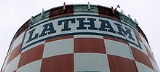
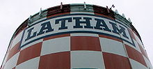 Latham's most conspicuous features are its red-and-white checkered water tower
s, the larger of which bears the hamlet's name, and the Latham Circle, a once-notorious traffic circle located near the site of the original Latham's Corners. The circle was recently modified to be more like a modern roundabout
, greatly improving its safety. Trees were once planted within the center of the roundabout, which plunges sharply down to an underpass, but the trees quickly withered and died.
Today, Latham Circle
is home to the Circle Diner (a modern recreation of the classic chrome diners of the 1950s), as well as a small strip mall, a bank and Latham Circle Mall
. Nearby, the derelict Latham School stood abandoned for decades until its demolition in April 2007, its students long since transferred to newer facilities within the North Colonie Central Schools
district in the 1960s.
Latham Circle Mall was one of America's earliest indoor shopping malls.. While this retail destination remains open to this day, it has been in physical and financial decline for well over a decade, primarily since the opening of Crossgates Mall
in nearby Guilderland
, as well as the nearby Latham Farms big box store complex.
Other sites of historic or geologic interest in Latham include several small historic cemeteries now surrounded by retail or residential developments, and a sequence of slate and shale
cliffs and canyon
s behind Shaker High School (from which nearby Blue Creek Elementary School takes it name) and between Haswell Road and New York State Route 2
. Some of these sites are now on private property, and require owners' or town clearance for access.
(FAA) considers the Latham water towers to be potential obstructions to air traffic approach paths at Albany International Airport
, as the higher tower protrudes nearly 60 feet (18.3 m) into east (Runway 28) approach. In future planning of putting ILS
systems into runway 10/28, the tower must be moved. To address this concern, the Airport Authority has developed a plan to remove the towers and replace them with a new structure on a 12 acres (48,562.3 m²), Town of Colonie owned parcel near the Albany Reservoir. This plan has been controversial, as some residents are concerned that the removal of the towers will allow lower approaches by aircraft, thereby increasing noise pollution levels.
March 1st, 2011, demolition began on the Latham Water Tower by starting the removal of the famous red and white checkered paint. According to Latham Water District Superintendent, John Frazer, the project would have started almost a month and a half earlier, in January 2011, but was delayed due to feet of ice that was contained within the tower. After about a month of warmer temperatures, combined with efforts of running water through it, the ice has melted, and project as started to be put back on track.
Another concern, which has also delayed the project, was fear of contamination of nearby waters. The contractor of Schultz Construction, Inc. warned that the stripping of metal from the tower would have a great possibility of falling and polluting waters near the tower. The situation was rectified, with the decision that, in addition to the metal being recycled; the surrounding water would be disposed of, to rid the area of any possible hazardous materials.
The total cost of the project, to be paid for by the FFA; through the American Recovery and Reinvestment Act of 2009, the Albany Airport Authority and New York State Department of Transportation, will be an estimated $11.1 million.
The new tower that will be used for the Town of Colonie is located 343A Albany Shaker Road. It was built in 2008 and was built to hold 2.5 million gallons of water.
The process to take down the tower is expected to take four weeks.
Rapid commercial and residential development and resultant traffic increases have also been issues of concern and controversy in Latham, in the core retail corridors near Latham Circle, Latham Farms, and between Interstate 87 and Wade Road. The Town of Colonie recently completed land use and development studies of the Route 2 and Route 7 corridors. Temporary building moratoriums were placed in large parts of the western sections of Latham in response to community concerns. In August 2005, the Town of Colonie issued a Comprehensive Plan that will provide the guidelines and framework for future development of Latham and its surrounding hamlets and incorporated villages within the town.
Albany County, New York
Albany County is a county located in the U.S. state of New York, and is part of the Albany-Schenectady-Troy Metropolitan Statistical Area. The name is from the title of the Duke of York and Albany, who became James II of England . As of the 2010 census, the population was 304,204...
, New York
New York
New York is a state in the Northeastern region of the United States. It is the nation's third most populous state. New York is bordered by New Jersey and Pennsylvania to the south, and by Connecticut, Massachusetts and Vermont to the east...
, United States
United States
The United States of America is a federal constitutional republic comprising fifty states and a federal district...
. It is located along U.S. Route 9 in the town of Colonie
Colonie (town), New York
Colonie is a town in Albany County, New York, United States. It is the most populous suburb of Albany, New York, and is the third largest town in area in Albany County, occupying about 11% of the county. Several hamlets exist within the town. As of the 2010 census, the town had a total population...
, a dense suburb
Suburb
The word suburb mostly refers to a residential area, either existing as part of a city or as a separate residential community within commuting distance of a city . Some suburbs have a degree of administrative autonomy, and most have lower population density than inner city neighborhoods...
north of Albany
Albany, New York
Albany is the capital city of the U.S. state of New York, the seat of Albany County, and the central city of New York's Capital District. Roughly north of New York City, Albany sits on the west bank of the Hudson River, about south of its confluence with the Mohawk River...
.
History
The area was known at different times in its history as Yearsley's (c. 1829), Van Vranken's (c. 1851), Town House Corners (c. 1860) and Latham's Corners, named after hotel owner William G. Latham. The "corner" referred to is now the intersection of Troy-Schenectady Road (NY Route 7) and Old Loudon Road.The Old Loudon Road was built in 1755 during the French and Indian War
French and Indian War
The French and Indian War is the common American name for the war between Great Britain and France in North America from 1754 to 1763. In 1756, the war erupted into the world-wide conflict known as the Seven Years' War and thus came to be regarded as the North American theater of that war...
to bring troops and provisions from Albany to the areas of Lake George
Lake George (New York)
Lake George, nicknamed the Queen of American Lakes, is a long, narrow oligotrophic lake draining northwards into Lake Champlain and the St. Lawrence River Drainage basin located at the southeast base of the Adirondack Mountains in northern New York, U.S.A.. It lies within the upper region of the...
and Ticonderoga
Ticonderoga
Ticonderoga may refer to :*Ticonderoga, New York, a town in New York, United States*Ticonderoga , New York, a hamlet in New York, United States*Fort Ticonderoga, a fortification in New YorkIn ships:*Ticonderoga...
. The Troy and Schenectady Turnpike was built in 1802 and intersected Old Loudon. An early first resident of this hamlet was Jonas Yearsley, 1785, who later built the first hotel close to this intersection. The hamlet was known first under the name of Yearsley's Corners and years afterward as Van Vrankens Corners in the 1850s. The name changed into Latham when William Latham became owner of the hotel. James, his son, continued to run the hotel until he died on August 14, 1933.
Geography
The hamlet itself is very narrow east-west and relatively long north-south, centered on the intersection of the Troy-Schenectady Road and Old Loudon Road. As a hamlet it's boundaries are inexact though they are marked by the New York State Department of TransportationNew York State Department of Transportation
The New York State Department of Transportation is responsible for the development and operation of highways, railroads, mass transit systems, ports, waterways and aviation facilities in the U.S...
on the west and east ends on New York Route 2 and on the south end on US Route 9 (US 9). On the west end the hamlet begins near the entrance to Latham Circle Mall
Latham Circle Mall
Latham Circle Mall is an enclosed shopping mall located adjacent to the Latham Circle in Latham, New York. Built in 1957 as Latham Corners Shopping Center, the mall was renovated several times in its history. It is anchored by JCPenney, Regal Cinemas, Burlington Coat Factory, and Lowe's Home...
; on the south end it starts near the Y-intersection of US 9 and Old Loudon Road; and on the east end the border is near the Kiwanis Park. The northern border is not marked. The area normally referred to as "Latham" extends well beyond the hamlet itself, as the name is also used for the post office of the 12110 ZIP Code
ZIP Code
ZIP codes are a system of postal codes used by the United States Postal Service since 1963. The term ZIP, an acronym for Zone Improvement Plan, is properly written in capital letters and was chosen to suggest that the mail travels more efficiently, and therefore more quickly, when senders use the...
. Many locations often considered in the northern and northeastern parts of Latham are in the Cohoes ZIP Code, while many in the eastern sections use a Watervliet ZIP Code.
Latham's terrain is mostly a hilly mix of deciduous and evergreen trees, with some pond
Pond
A pond is a body of standing water, either natural or man-made, that is usually smaller than a lake. A wide variety of man-made bodies of water are classified as ponds, including water gardens, water features and koi ponds; all designed for aesthetic ornamentation as landscape or architectural...
s, creeks
Stream
A stream is a body of water with a current, confined within a bed and stream banks. Depending on its locale or certain characteristics, a stream may be referred to as a branch, brook, beck, burn, creek, "crick", gill , kill, lick, rill, river, syke, bayou, rivulet, streamage, wash, run or...
and swamp
Swamp
A swamp is a wetland with some flooding of large areas of land by shallow bodies of water. A swamp generally has a large number of hammocks, or dry-land protrusions, covered by aquatic vegetation, or vegetation that tolerates periodical inundation. The two main types of swamp are "true" or swamp...
s, including several protected water courses and New York State Wetlands. Streams east of Old Loudon Road and US 9 generally drain into the Hudson River
Hudson River
The Hudson is a river that flows from north to south through eastern New York. The highest official source is at Lake Tear of the Clouds, on the slopes of Mount Marcy in the Adirondack Mountains. The river itself officially begins in Henderson Lake in Newcomb, New York...
; west of Old Loudon and US 9, the hamlet's watercourses drain into the Mohawk River
Mohawk River
The Mohawk River is a river in the U.S. state of New York. It is the largest tributary of the Hudson River. The Mohawk flows into the Hudson in the Capital District, a few miles north of the city of Albany. The river is named for the Mohawk Nation of the Iroquois Confederacy...
.
Location
Landmarks
Water tower
A water tower or elevated water tower is a large elevated drinking water storage container constructed to hold a water supply at a height sufficient to pressurize a water distribution system....
s, the larger of which bears the hamlet's name, and the Latham Circle, a once-notorious traffic circle located near the site of the original Latham's Corners. The circle was recently modified to be more like a modern roundabout
Roundabout
A roundabout is the name for a road junction in which traffic moves in one direction around a central island. The word dates from the early 20th century. Roundabouts are common in many countries around the world...
, greatly improving its safety. Trees were once planted within the center of the roundabout, which plunges sharply down to an underpass, but the trees quickly withered and died.
Today, Latham Circle
Latham Circle
The Latham Circle is the intersection of US Route 9 and NY Route 2 within the town of Colonie, New York in Albany County.-Description:The circle takes the name from the hamlet of Latham, of which the circle is close to the exact center...
is home to the Circle Diner (a modern recreation of the classic chrome diners of the 1950s), as well as a small strip mall, a bank and Latham Circle Mall
Latham Circle Mall
Latham Circle Mall is an enclosed shopping mall located adjacent to the Latham Circle in Latham, New York. Built in 1957 as Latham Corners Shopping Center, the mall was renovated several times in its history. It is anchored by JCPenney, Regal Cinemas, Burlington Coat Factory, and Lowe's Home...
. Nearby, the derelict Latham School stood abandoned for decades until its demolition in April 2007, its students long since transferred to newer facilities within the North Colonie Central Schools
North Colonie Central Schools
North Colonie Central Schools is a public school district located in Colonie, New York.-Merger with Maplewood-Colonie Common School District:In October 2007, the annexation of Maplewood-Colonie Common School District with the North Colonie Central School District was approved, 1446 yes to 277 no,...
district in the 1960s.
Latham Circle Mall was one of America's earliest indoor shopping malls.. While this retail destination remains open to this day, it has been in physical and financial decline for well over a decade, primarily since the opening of Crossgates Mall
Crossgates Mall
Crossgates Mall is a shopping mall located in Albany, New York, United States, not far from Schenectady. The mall opened on March 4, 1984, and in October 1994 underwent a large expansion that nearly doubled its size. It now has a gross leasable area of with two floors including 250 shops and...
in nearby Guilderland
Guilderland, New York
Guilderland is a town in Albany County, New York, United States. In the 2010 census, the town had a population of 35,303. The town is named for the Gelderland province in the Netherlands....
, as well as the nearby Latham Farms big box store complex.
Other sites of historic or geologic interest in Latham include several small historic cemeteries now surrounded by retail or residential developments, and a sequence of slate and shale
Shale
Shale is a fine-grained, clastic sedimentary rock composed of mud that is a mix of flakes of clay minerals and tiny fragments of other minerals, especially quartz and calcite. The ratio of clay to other minerals is variable. Shale is characterized by breaks along thin laminae or parallel layering...
cliffs and canyon
Canyon
A canyon or gorge is a deep ravine between cliffs often carved from the landscape by a river. Rivers have a natural tendency to reach a baseline elevation, which is the same elevation as the body of water it will eventually drain into. This forms a canyon. Most canyons were formed by a process of...
s behind Shaker High School (from which nearby Blue Creek Elementary School takes it name) and between Haswell Road and New York State Route 2
New York State Route 2
New York State Route 2 is a state highway in the Capital District of New York, United States. It extends from an interchange with Interstate 87 and NY 7 in the hamlet of Latham within the town of Colonie to the Massachusetts state line, where it continues to Boston as Route 2....
. Some of these sites are now on private property, and require owners' or town clearance for access.
Controversies
The Federal Aviation AdministrationFederal Aviation Administration
The Federal Aviation Administration is the national aviation authority of the United States. An agency of the United States Department of Transportation, it has authority to regulate and oversee all aspects of civil aviation in the U.S...
(FAA) considers the Latham water towers to be potential obstructions to air traffic approach paths at Albany International Airport
Albany International Airport
Albany International Airport is a public use airport located six nautical miles northwest of the central business district of Albany, in Albany County, New York, United States. It is owned by the Albany County Airport Authority....
, as the higher tower protrudes nearly 60 feet (18.3 m) into east (Runway 28) approach. In future planning of putting ILS
Instrument Landing System
An instrument landing system is a ground-based instrument approach system that provides precision guidance to an aircraft approaching and landing on a runway, using a combination of radio signals and, in many cases, high-intensity lighting arrays to enable a safe landing during instrument...
systems into runway 10/28, the tower must be moved. To address this concern, the Airport Authority has developed a plan to remove the towers and replace them with a new structure on a 12 acres (48,562.3 m²), Town of Colonie owned parcel near the Albany Reservoir. This plan has been controversial, as some residents are concerned that the removal of the towers will allow lower approaches by aircraft, thereby increasing noise pollution levels.
March 1st, 2011, demolition began on the Latham Water Tower by starting the removal of the famous red and white checkered paint. According to Latham Water District Superintendent, John Frazer, the project would have started almost a month and a half earlier, in January 2011, but was delayed due to feet of ice that was contained within the tower. After about a month of warmer temperatures, combined with efforts of running water through it, the ice has melted, and project as started to be put back on track.
Another concern, which has also delayed the project, was fear of contamination of nearby waters. The contractor of Schultz Construction, Inc. warned that the stripping of metal from the tower would have a great possibility of falling and polluting waters near the tower. The situation was rectified, with the decision that, in addition to the metal being recycled; the surrounding water would be disposed of, to rid the area of any possible hazardous materials.
The total cost of the project, to be paid for by the FFA; through the American Recovery and Reinvestment Act of 2009, the Albany Airport Authority and New York State Department of Transportation, will be an estimated $11.1 million.
The new tower that will be used for the Town of Colonie is located 343A Albany Shaker Road. It was built in 2008 and was built to hold 2.5 million gallons of water.
The process to take down the tower is expected to take four weeks.
Rapid commercial and residential development and resultant traffic increases have also been issues of concern and controversy in Latham, in the core retail corridors near Latham Circle, Latham Farms, and between Interstate 87 and Wade Road. The Town of Colonie recently completed land use and development studies of the Route 2 and Route 7 corridors. Temporary building moratoriums were placed in large parts of the western sections of Latham in response to community concerns. In August 2005, the Town of Colonie issued a Comprehensive Plan that will provide the guidelines and framework for future development of Latham and its surrounding hamlets and incorporated villages within the town.