

New York State Route 8
Encyclopedia
New York State Route 8 (NY 8) is a state highway
in the central part of New York
in the United States
. It runs in a southwest-to-northeast direction from the Southern Tier
to the northern part of Lake George
. The southern terminus of the route is at an interchange with NY 17
in the town of Deposit
, where it begins concurrent
with NY 10
. Its northern terminus is at a junction with NY 9N
in the town of Hague
. Roughly midway between the two endpoints, NY 8 passes through Utica
, where it overlaps NY 5
, NY 12
, and Interstate 790 (I-790) along one segment of the North–South Arterial.
NY 8 was assigned as part of the 1930 renumbering of state highways in New York and originally extended north to a ferry across Lake Champlain
at Putnam Station, where it connected to Vermont Route F-10 (VT F-10). The route was realigned slightly on its northern end by 1933 to connect to another ferry leading to VT F-9 east of Ticonderoga. By the following year, it was altered again to use the new Champlain Bridge
at Crown Point
to connect to VT 17
. This was made possible by way of a long concurrency with NY 9N
and NY 22
. NY 8 was truncated to its current northern terminus ca. 1968. In the 1960s and 1970s, NY 8 was moved onto new freeways around and through the city of Utica.
. NY 8 and NY 10 form a brief concurrency
north along the West Branch of the Delaware River
before separating at the southeastern edge of the Cannonsville Reservoir
northeast of Deposit. While NY 10 follows the southern edge of the reservoir to the east, NY 8 continues north, passing to the east of Oquaga Creek State Park
(and connecting to the park via a pair of local roads) before meeting NY 206
in Masonville
. From Masonville, NY 8 heads north to Sidney
, where it meets I-88
at an interchange, crosses the Susquehanna River
, and intersects NY 7
before leaving the village adjacent to the Unadilla River
, a tributary of the Susquehanna.
 NY 8 parallels the Unadilla River northward through Mount Upton
to New Berlin
, where it meets NY 80
. The routes overlap for a short distance to the north before NY 80 separates to the northwest toward Sherburne
. NY 8, however, continues along the Unadilla River through several small communities before separating from the river just south of the Madison
-Oneida
County line.
. The route continues northward, passing through Cassville
and Clayville
before becoming a limited-access highway just north of Clayville. Near Sauquoit, NY 8 has exits for Pinnacle Road and Elm Street prior to entering the Utica
suburbs. In New Hartford
, the route has an exit with Genesee Street prior to meeting NY 5
and NY 12
at a cloverleaf interchange
southwest of downtown Utica. While the right-of-way of NY 8 continues to the northeast through the cloverleaf as NY 840
, NY 8 joins NY 5 and NY 12 as the three routes enter downtown on the North–South Arterial.
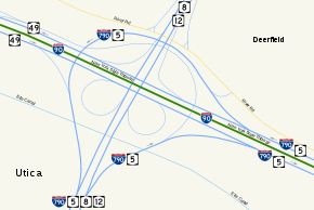 Near the northern edge of downtown, NY 5, NY 8, and NY 12 interchange with NY 5A
and NY 5S
on the southern bank of the Mohawk River
. At the exit, the three states are joined on the arterial by I-790
, which follows NY 5, NY 8, and NY 12 across the Mohawk River and the neighboring Erie Canal
to a large interchange north of the canal. Here, I-790 and NY 5 separate from the concurrency while NY 8 and NY 12 remain concurrent into Deerfield
as a limited-access highway. After an interchange with a former routing of NY 12, NY 8 separates from the highway and returns to an at-grade roadway as it heads northeast to Poland
. Near the Oneida-Herkimer County
line (here delimited by West Canada Creek
), NY 8 merges with NY 28
and follows the route across the county line (as well as the creek) into Poland. In the center of the village, NY 8 splits from NY 28 and heads northeast into Adirondack Park.
, NY 8 intersects NY 365
due north of where it enters the park. Past NY 365, NY 8 becomes signed as an east–west highway as it heads east to Higgins Bay, where it intersects the northern terminus of NY 10. The route continues northeast to Speculator
, where it meets NY 30
. NY 30 turns east onto NY 8, forming an overlap southeast to Wells
, where NY 8 separates from NY 30 and heads to the northeast into Warren County
.
In Wevertown
, NY 8 intersects NY 28 for the final time prior to meeting US 9 at Loon Lake
. The two routes merge, forming an overlap east to Chestertown
, where US 9 splits from NY 8 and continues south. NY 8, however, heads east, meeting I-87
shortly after departing US 9. Past I-87, NY 8 follows the southern edge of Brant Lake to the northeast before turning to the east toward Hague
, where it terminates at NY 9N
.
 In the 1930 renumbering of state highways in New York, NY 8 was assigned to most of its current alignment from Deposit to Hague. The route also extended eastward to Wright (southeast of Ticonderoga
) on modern NY 9N
, NY 22
, and County Route 2 (CR 2), where it connected to VT F-10 by way of a ferry
across Lake Champlain
. From Clayville
to Utica, NY 8 was originally routed along Oneida Street before overlapping with NY 5 and NY 12 along Genesee Street in downtown Utica. After crossing the Mohawk River
and the Erie Canal
, the three routes separated at the intersection of Herkimer Road, Trenton Road, and Coventry Avenue northeast of downtown. NY 8 then followed Coventry Avenue and Walker Road northeast to Deerfield
, where NY 8 joined its modern alignment.
Prior to 1930, what became NY 8 in the renumbering carried multiple designations along its routing. In 1924, the segment of Genesee Street in Utica that became NY 8 was designated as part of NY 5
and NY 12
. Additionally, the portion of NY 8 from Wevertown
to Chestertown
became part of NY 10
. The segment from the modern intersection of US 9 and NY 8 to Chestertown was also designated as part of NY 6. By 1926, what became NY 8 from Sidney to New Berlin
and from Bridgewater
to downtown Utica was designated as NY 44. Between New Berlin and Bridgewater, NY 44 followed what is now NY 80
through Edmeston
to West Burlington and NY 51
from West Burlington to US 20. NY 44 overlapped US 20 west to Bridgewater. From Utica to Wells
, the 1930 routing of NY 8 was part of NY 54. Between Chestertown and Ticonderoga
, NY 8 was designated NY 47. Until the renumbering, what became NY 8 was unbuilt from Deposit to Masonville
and unnumbered from Masonville to Sidney. Additionally, the segments from New Berlin to Bridgewater and from Wells to Wevertown were unnumbered.
NY 8 was rerouted by 1933 to exit Ticonderoga to the east, using what is now NY 74
to reach Lake Champlain instead. At the lake, NY 8 connected to VT F-9 via the Fort Ticonderoga – Larrabees Point Ferry. The route was realigned again ca. 1934 to follow NY 9N and NY 22 north from Ticonderoga to south of Port Henry
, where NY 8 turned northeast to follow what is now NY 185
to the Champlain Bridge
. The route became VT 17
on the opposite lakeshore. NY 8 was truncated to Hague ca. 1968, eliminating its overlaps with NY 9N and NY 22.
) by 1961 and completed entirely by 1964; however, NY 8 was not initially realigned to follow the highway. In the mid-1960s, plans were made to construct a new limited-access highway along the NY 8 corridor from Clayville
north to New Hartford
, where it would connect with the North–South Arterial.
The freeway was constructed and completed in the early 1970s. NY 8 was realigned to follow the highway to New Hartford, from where it continued through Utica on the Arterial and I-790. It rejoined its previous alignment at I-790's interchange with Genesee Street. During this same period, the section of NY 12 between Deerfield and South Trenton was moved onto a new freeway built adjacent to NY 12's original alignment. A connector between NY 12 and NY 8 by way of the Miller Road corridor was built at this time. NY 8 was rerouted in the mid-1970s to follow NY 12 north to its exit with the connector. Here, NY 8 left NY 12 and continued east on the connector to rejoin its original alignment at Walker Road. Ownership and maintenance of NY 8's former routing north of the Utica city limits was transferred to Oneida County
, which designated the highway as CR 92.
State highway
State highway, state road or state route can refer to one of three related concepts, two of them related to a state or provincial government in a country that is divided into states or provinces :#A...
in the central part of New York
New York
New York is a state in the Northeastern region of the United States. It is the nation's third most populous state. New York is bordered by New Jersey and Pennsylvania to the south, and by Connecticut, Massachusetts and Vermont to the east...
in the United States
United States
The United States of America is a federal constitutional republic comprising fifty states and a federal district...
. It runs in a southwest-to-northeast direction from the Southern Tier
Southern Tier
The Southern Tier is a geographical term that refers to the counties of New York State west of the Catskill Mountains along the northern border of Pennsylvania. It is a loosely defined term that generally includes the counties that border Pennsylvania west of Delaware County inclusive...
to the northern part of Lake George
Lake George (New York)
Lake George, nicknamed the Queen of American Lakes, is a long, narrow oligotrophic lake draining northwards into Lake Champlain and the St. Lawrence River Drainage basin located at the southeast base of the Adirondack Mountains in northern New York, U.S.A.. It lies within the upper region of the...
. The southern terminus of the route is at an interchange with NY 17
New York State Route 17
New York State Route 17 is a state highway that extends for through the Southern Tier and Downstate regions of New York in the United States...
in the town of Deposit
Deposit (town), New York
Deposit, New York is a town in Delaware County, New York, USA in the USA.The Town of Deposit is on the western border of the county and contains part of a village, also called Deposit.- History :...
, where it begins concurrent
Concurrency (road)
A concurrency, overlap, or coincidence in a road network is an instance of one physical road bearing two or more different highway, motorway, or other route numbers...
with NY 10
New York State Route 10
New York State Route 10 is a north–south state highway in the Central New York and North Country regions of New York in the United States. It extends for from the Quickway in Deposit, Delaware County to NY 8 at Higgins Bay, a hamlet in the Hamilton County town of Arietta...
. Its northern terminus is at a junction with NY 9N
New York State Route 9N
New York State Route 9N is a north–south state highway in northeastern New York, United States. It extends from an intersection with U.S. Route 9 , NY 29, and NY 50 in the city of Saratoga Springs to a junction with US 9 and NY 22 in the Clinton County village of...
in the town of Hague
Hague, New York
Hague is a town in northeastern Warren County, New York, United States located on the scenic Lake George. It is part of the Glens Falls Metropolitan Statistical Area. The population was 854 at the 2000 census...
. Roughly midway between the two endpoints, NY 8 passes through Utica
Utica, New York
Utica is a city in and the county seat of Oneida County, New York, United States. The population was 62,235 at the 2010 census, an increase of 2.6% from the 2000 census....
, where it overlaps NY 5
New York State Route 5
New York State Route 5 is a state highway that extends for across the state of New York in the United States. It begins at the Pennsylvania state line in the Chautauqua County town of Ripley and passes through Buffalo, Syracuse, Utica, Schenectady, and several other smaller cities and...
, NY 12
New York State Route 12
New York State Route 12 is a state highway extending for through central and northern New York in the United States. The southern terminus of the route is at U.S. Route 11 in the town of Chenango in the Southern Tier. The northern terminus is at NY 37 near the village of...
, and Interstate 790 (I-790) along one segment of the North–South Arterial.
NY 8 was assigned as part of the 1930 renumbering of state highways in New York and originally extended north to a ferry across Lake Champlain
Lake Champlain
Lake Champlain is a natural, freshwater lake in North America, located mainly within the borders of the United States but partially situated across the Canada—United States border in the Canadian province of Quebec.The New York portion of the Champlain Valley includes the eastern portions of...
at Putnam Station, where it connected to Vermont Route F-10 (VT F-10). The route was realigned slightly on its northern end by 1933 to connect to another ferry leading to VT F-9 east of Ticonderoga. By the following year, it was altered again to use the new Champlain Bridge
Champlain Bridge (United States)
The Champlain Bridge was a long vehicular bridge in the United States that traversed Lake Champlain between Crown Point, New York and Chimney Point, Vermont. It was opened to traffic in 1929 as a toll bridge; the tolls were removed in 1987...
at Crown Point
Crown Point, New York
Crown Point is a town in Essex County, New York, USA. The population was 2,119 at the 2000 census. The name of the town is a direct translation of the original French name, "Point au Chevalure."...
to connect to VT 17
Vermont Route 17
Vermont Route 17 is a long state highway in western Vermont, United States. The temporary western terminus is at the Lake Champlain shoreline in Addison just west of its junction with VT 125. The eastern terminus is at VT 100 in Waitsfield. VT 17 was initially much shorter than it is today,...
. This was made possible by way of a long concurrency with NY 9N
New York State Route 9N
New York State Route 9N is a north–south state highway in northeastern New York, United States. It extends from an intersection with U.S. Route 9 , NY 29, and NY 50 in the city of Saratoga Springs to a junction with US 9 and NY 22 in the Clinton County village of...
and NY 22
New York State Route 22
New York State Route 22 is a north–south state highway in eastern New York in the United States. It runs parallel to the state's eastern edge from the outskirts of New York City to a short distance south of the Canadian border. At , it is the state's longest north–south route and...
. NY 8 was truncated to its current northern terminus ca. 1968. In the 1960s and 1970s, NY 8 was moved onto new freeways around and through the city of Utica.
Southern Tier
NY 8 begins at an interchange with NY 17 in Deposit that also serves as the southern terminus of NY 10New York State Route 10
New York State Route 10 is a north–south state highway in the Central New York and North Country regions of New York in the United States. It extends for from the Quickway in Deposit, Delaware County to NY 8 at Higgins Bay, a hamlet in the Hamilton County town of Arietta...
. NY 8 and NY 10 form a brief concurrency
Concurrency (road)
A concurrency, overlap, or coincidence in a road network is an instance of one physical road bearing two or more different highway, motorway, or other route numbers...
north along the West Branch of the Delaware River
West Branch Delaware River
The West Branch Delaware River, approximately 90 mi long in the U.S. states of New York and Pennsylvania, is one of the two branches, along with the East Branch, that join to form the Delaware River...
before separating at the southeastern edge of the Cannonsville Reservoir
Cannonsville Reservoir
The Cannonsville Reservoir is a reservoir in Delaware County, New York, that was formed by impounding over half of the West Branch of the Delaware River. It is the westernmost of New York City's reservoirs, being at the western portion of the Delaware Watershed. Placed in service in 1964, it is the...
northeast of Deposit. While NY 10 follows the southern edge of the reservoir to the east, NY 8 continues north, passing to the east of Oquaga Creek State Park
Oquaga Creek State Park
Oquaga Creek State Park is a state park at the border of Delaware County and Chenango County in New York in the USA.The park is partially in the Town of Masonville and partly in the Town of Sanford.Broome County Road 241 passes through the park....
(and connecting to the park via a pair of local roads) before meeting NY 206
New York State Route 206
New York State Route 206 is a state highway in the Southern Tier of New York, United States. It runs through some lightly populated regions along the state's southern border, from Central New York to the Catskills. It begins near a busy intersection with Interstate 81 at Whitney Point...
in Masonville
Masonville, New York
Masonville is a town in Delaware County, New York, United States. The population was 1,405 at the 2000 census.The Town of Masonville is in the western part of the county.- History :...
. From Masonville, NY 8 heads north to Sidney
Sidney (village), New York
Sidney is a village in Delaware County, New York, USA. The population was 4,068 at the 2000 census.The Village of Sidney is in west part of the Town of Sidney.-History:The village was named for Admiral Sir Sidney Smith.-Geography:...
, where it meets I-88
Interstate 88 (east)
Interstate 88 is an intrastate Interstate Highway entirely within the U.S. state of New York. Its western end is at Interstate 81 in Binghamton and its eastern end is at Interstate 90 in Schenectady. It serves as an important connector route from Albany to Binghamton, Elmira , and...
at an interchange, crosses the Susquehanna River
Susquehanna River
The Susquehanna River is a river located in the northeastern United States. At long, it is the longest river on the American east coast that drains into the Atlantic Ocean, and with its watershed it is the 16th largest river in the United States, and the longest river in the continental United...
, and intersects NY 7
New York State Route 7
New York State Route 7 is a 180-mile long New York State Highway that runs from the New York/Pennsylvania border south of Binghamton, New York to the New York/Vermont border east of Hoosick. Most of the road runs along the Susquehanna Valley, closely paralleling Interstate 88 throughout...
before leaving the village adjacent to the Unadilla River
Unadilla River
The Unadilla River in New York State flows from south of Utica to the village of Sidney, where it flows into the Susquehanna River, which eventually empties into the Chesapeake Bay, an arm of the Atlantic Ocean....
, a tributary of the Susquehanna.
Mount Upton, New York
Mount Upton is a hamlet on the Unadilla River in the town of Guilford in Chenango County, New York, United States....
to New Berlin
New Berlin (village), New York
New Berlin is a village in Chenango County, New York, USA. The population was 1,129 at the 2000 census.The Village of New Berlin is by the east town line of the Town of New Berlin. The village is east of Norwich....
, where it meets NY 80
New York State Route 80
New York State Route 80 is a west–east New York State Route located within Onondaga, Madison, Chenango, Otsego, Herkimer, and Montgomery Counties in New York. Its western terminus is located at a junction with NY 175 in the city of Syracuse in Onondaga County, from which it...
. The routes overlap for a short distance to the north before NY 80 separates to the northwest toward Sherburne
Sherburne (village), New York
Sherburne is a village in Chenango County, New York, USA. The population was 1,455 at the 2000 census.The Village of Sherburne is in the Town of Sherburne, north of the City of Norwich.- History :...
. NY 8, however, continues along the Unadilla River through several small communities before separating from the river just south of the Madison
Madison County, New York
Madison County is a county located in the U.S. state of New York. As of the 2010 census, the population was 73,442. It is named after James Madison, fourth President of the United States of America...
-Oneida
Oneida County, New York
Oneida County is a county located in the U.S. state of New York. As of the 2010 census, the population was 234,878. The county seat is Utica. The name is in honor of the Oneida, an Iroquoian tribe that formerly occupied the region....
County line.
Utica area
Shortly after crossing into Oneida County, NY 8 intersects U.S. Route 20 (US 20) in BridgewaterBridgewater (village), New York
Bridgewater is a village in Oneida County, New York, USA. The population was 579 at the 2000 census.The Village of Bridgewater is within the Town of Bridgewater at the junction of US Route 20 and Route 8.- History :...
. The route continues northward, passing through Cassville
Cassville, New York
Cassville is a hamlet in Oneida County, New York, United States. Cassville is situated at the intersection of New York State Route 8 in the town of Paris.-Notable residents:...
and Clayville
Clayville, New York
Clayville is a village in Oneida County, New York, USA. The population was 445 at the 2000 census.The Village of Clayville is inside the Town of Paris.- History :Clayville was incorporated in 1887....
before becoming a limited-access highway just north of Clayville. Near Sauquoit, NY 8 has exits for Pinnacle Road and Elm Street prior to entering the Utica
Utica, New York
Utica is a city in and the county seat of Oneida County, New York, United States. The population was 62,235 at the 2010 census, an increase of 2.6% from the 2000 census....
suburbs. In New Hartford
New Hartford (village), New York
New Hartford is a village in Oneida County, New York, United States. The population was 1,886 at the 2000 census. The name was provided by early settlers for New Hartford, Connecticut....
, the route has an exit with Genesee Street prior to meeting NY 5
New York State Route 5
New York State Route 5 is a state highway that extends for across the state of New York in the United States. It begins at the Pennsylvania state line in the Chautauqua County town of Ripley and passes through Buffalo, Syracuse, Utica, Schenectady, and several other smaller cities and...
and NY 12
New York State Route 12
New York State Route 12 is a state highway extending for through central and northern New York in the United States. The southern terminus of the route is at U.S. Route 11 in the town of Chenango in the Southern Tier. The northern terminus is at NY 37 near the village of...
at a cloverleaf interchange
Cloverleaf interchange
A cloverleaf interchange is a two-level interchange in which left turns, reverse direction in left-driving regions, are handled by ramp roads...
southwest of downtown Utica. While the right-of-way of NY 8 continues to the northeast through the cloverleaf as NY 840
New York State Route 840
New York State Route 840 is an east–west state highway in Oneida County, New York, United States. It is a superhighway extension of Judd Road , which ended at Halsey Road in Whitestown prior to the construction of NY 840...
, NY 8 joins NY 5 and NY 12 as the three routes enter downtown on the North–South Arterial.
New York State Route 5A
New York State Route 5A is an east–west state highway contained within Oneida County, New York, in the United States. It is a alternate route of NY 5 between New Hartford and downtown Utica. At its eastern end, NY 5A becomes NY 5S. The route is four lanes wide and passes...
and NY 5S
New York State Route 5S
New York State Route 5S is an east–west state highway located in the Mohawk Valley of New York in the United States. It extends for from an interchange with NY 5, NY 5A, NY 8, and NY 12 in Utica to a smaller interchange with NY 890 in Rotterdam...
on the southern bank of the Mohawk River
Mohawk River
The Mohawk River is a river in the U.S. state of New York. It is the largest tributary of the Hudson River. The Mohawk flows into the Hudson in the Capital District, a few miles north of the city of Albany. The river is named for the Mohawk Nation of the Iroquois Confederacy...
. At the exit, the three states are joined on the arterial by I-790
Interstate 790
Interstate 790 is an auxiliary Interstate Highway in the city of Utica, New York, in the United States. It runs for from an interchange with NY 5A and NY 5S in downtown Utica to exit 31 of the New York State Thruway east of the city...
, which follows NY 5, NY 8, and NY 12 across the Mohawk River and the neighboring Erie Canal
Erie Canal
The Erie Canal is a waterway in New York that runs about from Albany, New York, on the Hudson River to Buffalo, New York, at Lake Erie, completing a navigable water route from the Atlantic Ocean to the Great Lakes. The canal contains 36 locks and encompasses a total elevation differential of...
to a large interchange north of the canal. Here, I-790 and NY 5 separate from the concurrency while NY 8 and NY 12 remain concurrent into Deerfield
Deerfield, New York
Deerfield is a town in Oneida County, New York, United States. The population was 3,906 at the 2000 census.The Town of Deerfield is on the eastern border of the county and northeast of the City of Utica.- History :...
as a limited-access highway. After an interchange with a former routing of NY 12, NY 8 separates from the highway and returns to an at-grade roadway as it heads northeast to Poland
Poland, Herkimer County, New York
----Poland is a village in Herkimer County, New York, United States. The population was 451 at the 2000 census.The Village of Poland is at the town line shared by the Town of Newport and the Town of Russia. The village is 16 miles north of the county seat in Herkimer and is northeast of Utica...
. Near the Oneida-Herkimer County
Herkimer County, New York
Herkimer County is a county located in the U.S. state of New York. It was created in 1791 north of the Mohawk River out of part of Montgomery County. As of the 2010 census, the population was 64,519. It is named after General Nicholas Herkimer, who died from battle wounds in 1777 after taking part...
line (here delimited by West Canada Creek
West Canada Creek
West Canada Creek is a river in upstate New York, USA. West Canada Creek drains the south part of the Adirondack Mountains and empties into the Mohawk River near the Village of Herkimer...
), NY 8 merges with NY 28
New York State Route 28
New York State Route 28 is a state highway extending for in the shape of a "C" between the Hudson Valley city of Kingston and southern Warren County in the U.S. state of New York. Along the way, it intersects several major routes, including Interstate 88 , U.S. Route 20 , and the...
and follows the route across the county line (as well as the creek) into Poland. In the center of the village, NY 8 splits from NY 28 and heads northeast into Adirondack Park.
Adirondack Park
Within Adirondack Park, NY 8 follows a northeast–southwest routing as it crosses the lower half of the park. Near OhioOhio, New York
Ohio is a town in Herkimer County, New York, United States. The population was 922 at the 2000 census. The town is named after the state of Ohio. The town is in the northwest part of the county and northeast of Utica. Part of Ohio is within the Adirondack Park....
, NY 8 intersects NY 365
New York State Route 365
New York State Route 365 is an east–west state highway in the central portion of New York in the United States. It extends for from an intersection with NY 5 east of the Oneida County city of Oneida to a junction with NY 8 in the Herkimer County town of Ohio...
due north of where it enters the park. Past NY 365, NY 8 becomes signed as an east–west highway as it heads east to Higgins Bay, where it intersects the northern terminus of NY 10. The route continues northeast to Speculator
Speculator, New York
Speculator is a village in Hamilton County, New York, United States. The population was 348 at the 2000 census. The village is named after a nearby Speculator Mountain....
, where it meets NY 30
New York State Route 30
New York State Route 30 is a state highway in the central part of New York in the United States. It extends for from an interchange with NY 17 in the Southern Tier to the Canadian border in the state's North Country, where it continues into Quebec as Route 138. On a regional level,...
. NY 30 turns east onto NY 8, forming an overlap southeast to Wells
Wells, New York
Wells is a town in Hamilton County, New York, United States. The population was 737 at the 2000 census. The town is named after Joshua Wells, a land agent, who built the first mills in the area....
, where NY 8 separates from NY 30 and heads to the northeast into Warren County
Warren County, New York
Warren County is a county in the U.S. state of New York. It is part of the Glens Falls, New York, Metropolitan Statistical Area. As of the 2010 census, the population was 65,707. It is named in honor of General Joseph Warren, an American Revolutionary War hero of the Battle of Bunker Hill...
.
In Wevertown
Wevertown, New York
Wevertown, New York, is a hamlet in the Adirondack Mountains/Adirondack Park. It is in the town of Johnsburg in the northwest corner of Warren County, New York, U.S.A., and is in the Glens Falls metropolitan area.- Geography:...
, NY 8 intersects NY 28 for the final time prior to meeting US 9 at Loon Lake
Loon Lake (Warren County, New York)
Loon Lake is a wishbone-shaped body of water in Warren County, New York. It is located within the Town of Chester, which maintains the beach. Fishing and boating are popular activities. Common fish species within the lake include Pumpkinseed sunfish, Rock bass, Perch, Smallmouth bass, Largemouth...
. The two routes merge, forming an overlap east to Chestertown
Chestertown, New York
Chestertown is a hamlet in Warren County, New York, United States, in the Adirondack Mountains, in the Town of Chester. The population was 2,187 at the 2000 census. The community is located by the junction of Route 8 and U.S. Route 9....
, where US 9 splits from NY 8 and continues south. NY 8, however, heads east, meeting I-87
Interstate 87
Interstate 87 is a Interstate Highway located entirely within New York State in the United States of America. I-87 is the longest intrastate Interstate highway in the Interstate Highway System. Its southern end is at the Bronx approaches of the Robert F. Kennedy Bridge in New York City...
shortly after departing US 9. Past I-87, NY 8 follows the southern edge of Brant Lake to the northeast before turning to the east toward Hague
Hague, New York
Hague is a town in northeastern Warren County, New York, United States located on the scenic Lake George. It is part of the Glens Falls Metropolitan Statistical Area. The population was 854 at the 2000 census...
, where it terminates at NY 9N
New York State Route 9N
New York State Route 9N is a north–south state highway in northeastern New York, United States. It extends from an intersection with U.S. Route 9 , NY 29, and NY 50 in the city of Saratoga Springs to a junction with US 9 and NY 22 in the Clinton County village of...
.
Origins and terminus changes
Ticonderoga, New York
Ticonderoga is a town in Essex County, New York, USA. The population was 5,167 at the 2000 census. The name comes from the Mohawk tekontaró:ken, meaning "it is at the junction of two waterways"....
) on modern NY 9N
New York State Route 9N
New York State Route 9N is a north–south state highway in northeastern New York, United States. It extends from an intersection with U.S. Route 9 , NY 29, and NY 50 in the city of Saratoga Springs to a junction with US 9 and NY 22 in the Clinton County village of...
, NY 22
New York State Route 22
New York State Route 22 is a north–south state highway in eastern New York in the United States. It runs parallel to the state's eastern edge from the outskirts of New York City to a short distance south of the Canadian border. At , it is the state's longest north–south route and...
, and County Route 2 (CR 2), where it connected to VT F-10 by way of a ferry
Ferry
A ferry is a form of transportation, usually a boat, but sometimes a ship, used to carry primarily passengers, and sometimes vehicles and cargo as well, across a body of water. Most ferries operate on regular, frequent, return services...
across Lake Champlain
Lake Champlain
Lake Champlain is a natural, freshwater lake in North America, located mainly within the borders of the United States but partially situated across the Canada—United States border in the Canadian province of Quebec.The New York portion of the Champlain Valley includes the eastern portions of...
. From Clayville
Clayville, New York
Clayville is a village in Oneida County, New York, USA. The population was 445 at the 2000 census.The Village of Clayville is inside the Town of Paris.- History :Clayville was incorporated in 1887....
to Utica, NY 8 was originally routed along Oneida Street before overlapping with NY 5 and NY 12 along Genesee Street in downtown Utica. After crossing the Mohawk River
Mohawk River
The Mohawk River is a river in the U.S. state of New York. It is the largest tributary of the Hudson River. The Mohawk flows into the Hudson in the Capital District, a few miles north of the city of Albany. The river is named for the Mohawk Nation of the Iroquois Confederacy...
and the Erie Canal
Erie Canal
The Erie Canal is a waterway in New York that runs about from Albany, New York, on the Hudson River to Buffalo, New York, at Lake Erie, completing a navigable water route from the Atlantic Ocean to the Great Lakes. The canal contains 36 locks and encompasses a total elevation differential of...
, the three routes separated at the intersection of Herkimer Road, Trenton Road, and Coventry Avenue northeast of downtown. NY 8 then followed Coventry Avenue and Walker Road northeast to Deerfield
Deerfield, New York
Deerfield is a town in Oneida County, New York, United States. The population was 3,906 at the 2000 census.The Town of Deerfield is on the eastern border of the county and northeast of the City of Utica.- History :...
, where NY 8 joined its modern alignment.
Prior to 1930, what became NY 8 in the renumbering carried multiple designations along its routing. In 1924, the segment of Genesee Street in Utica that became NY 8 was designated as part of NY 5
New York State Route 5
New York State Route 5 is a state highway that extends for across the state of New York in the United States. It begins at the Pennsylvania state line in the Chautauqua County town of Ripley and passes through Buffalo, Syracuse, Utica, Schenectady, and several other smaller cities and...
and NY 12
New York State Route 12
New York State Route 12 is a state highway extending for through central and northern New York in the United States. The southern terminus of the route is at U.S. Route 11 in the town of Chenango in the Southern Tier. The northern terminus is at NY 37 near the village of...
. Additionally, the portion of NY 8 from Wevertown
Wevertown, New York
Wevertown, New York, is a hamlet in the Adirondack Mountains/Adirondack Park. It is in the town of Johnsburg in the northwest corner of Warren County, New York, U.S.A., and is in the Glens Falls metropolitan area.- Geography:...
to Chestertown
Chestertown, New York
Chestertown is a hamlet in Warren County, New York, United States, in the Adirondack Mountains, in the Town of Chester. The population was 2,187 at the 2000 census. The community is located by the junction of Route 8 and U.S. Route 9....
became part of NY 10
New York State Route 10
New York State Route 10 is a north–south state highway in the Central New York and North Country regions of New York in the United States. It extends for from the Quickway in Deposit, Delaware County to NY 8 at Higgins Bay, a hamlet in the Hamilton County town of Arietta...
. The segment from the modern intersection of US 9 and NY 8 to Chestertown was also designated as part of NY 6. By 1926, what became NY 8 from Sidney to New Berlin
New Berlin (village), New York
New Berlin is a village in Chenango County, New York, USA. The population was 1,129 at the 2000 census.The Village of New Berlin is by the east town line of the Town of New Berlin. The village is east of Norwich....
and from Bridgewater
Bridgewater (village), New York
Bridgewater is a village in Oneida County, New York, USA. The population was 579 at the 2000 census.The Village of Bridgewater is within the Town of Bridgewater at the junction of US Route 20 and Route 8.- History :...
to downtown Utica was designated as NY 44. Between New Berlin and Bridgewater, NY 44 followed what is now NY 80
New York State Route 80
New York State Route 80 is a west–east New York State Route located within Onondaga, Madison, Chenango, Otsego, Herkimer, and Montgomery Counties in New York. Its western terminus is located at a junction with NY 175 in the city of Syracuse in Onondaga County, from which it...
through Edmeston
Edmeston, New York
Edmeston is a town located in Otsego County, New York, United States. As of the 2000 census, the town had a total population of 1,824.The Town of Edmeston is at the western county line. Edmeston is also the name of the largest hamlet in the town...
to West Burlington and NY 51
New York State Route 51
New York State Route 51 is a state highway in the central part of New York state. The highway runs generally in a southwest to northeast direction from the hamlet of Mount Upton to the village of Ilion...
from West Burlington to US 20. NY 44 overlapped US 20 west to Bridgewater. From Utica to Wells
Wells, New York
Wells is a town in Hamilton County, New York, United States. The population was 737 at the 2000 census. The town is named after Joshua Wells, a land agent, who built the first mills in the area....
, the 1930 routing of NY 8 was part of NY 54. Between Chestertown and Ticonderoga
Ticonderoga, New York
Ticonderoga is a town in Essex County, New York, USA. The population was 5,167 at the 2000 census. The name comes from the Mohawk tekontaró:ken, meaning "it is at the junction of two waterways"....
, NY 8 was designated NY 47. Until the renumbering, what became NY 8 was unbuilt from Deposit to Masonville
Masonville, New York
Masonville is a town in Delaware County, New York, United States. The population was 1,405 at the 2000 census.The Town of Masonville is in the western part of the county.- History :...
and unnumbered from Masonville to Sidney. Additionally, the segments from New Berlin to Bridgewater and from Wells to Wevertown were unnumbered.
NY 8 was rerouted by 1933 to exit Ticonderoga to the east, using what is now NY 74
New York State Route 74
New York State Route 74 and Vermont Route 74 are adjoining state highways in the northeastern United States, connected by one of the last remaining cable ferries in North America. Together they extend for through Essex County, New York, and Addison County, Vermont...
to reach Lake Champlain instead. At the lake, NY 8 connected to VT F-9 via the Fort Ticonderoga – Larrabees Point Ferry. The route was realigned again ca. 1934 to follow NY 9N and NY 22 north from Ticonderoga to south of Port Henry
Port Henry, New York
Port Henry is a village in Essex County, New York, United States. The population was 1,152 at the 2000 census.The Village of Port Henry lies on the east side of the Town of Moriah and is approximately one hour's drive south of Plattsburgh...
, where NY 8 turned northeast to follow what is now NY 185
New York State Route 185
New York State Route 185 was a state highway located within St. Lawrence County in the North Country of New York in the United States. Although the route followed a mostly north–south alignment, it was considered an east–west highway by the New York State Department of Transportation...
to the Champlain Bridge
Champlain Bridge (United States)
The Champlain Bridge was a long vehicular bridge in the United States that traversed Lake Champlain between Crown Point, New York and Chimney Point, Vermont. It was opened to traffic in 1929 as a toll bridge; the tolls were removed in 1987...
. The route became VT 17
Vermont Route 17
Vermont Route 17 is a long state highway in western Vermont, United States. The temporary western terminus is at the Lake Champlain shoreline in Addison just west of its junction with VT 125. The eastern terminus is at VT 100 in Waitsfield. VT 17 was initially much shorter than it is today,...
on the opposite lakeshore. NY 8 was truncated to Hague ca. 1968, eliminating its overlaps with NY 9N and NY 22.
Relocation onto expressways
In the early 1950s, construction began on a new arterial highway—known as the North–South Arterial—through downtown Utica. The first portion of the highway to open was the segment between River Road and Trenton Road, which was completed by 1956. It was extended southward to Oriskany Street (NY 5ANew York State Route 5A
New York State Route 5A is an east–west state highway contained within Oneida County, New York, in the United States. It is a alternate route of NY 5 between New Hartford and downtown Utica. At its eastern end, NY 5A becomes NY 5S. The route is four lanes wide and passes...
) by 1961 and completed entirely by 1964; however, NY 8 was not initially realigned to follow the highway. In the mid-1960s, plans were made to construct a new limited-access highway along the NY 8 corridor from Clayville
Clayville, New York
Clayville is a village in Oneida County, New York, USA. The population was 445 at the 2000 census.The Village of Clayville is inside the Town of Paris.- History :Clayville was incorporated in 1887....
north to New Hartford
New Hartford (village), New York
New Hartford is a village in Oneida County, New York, United States. The population was 1,886 at the 2000 census. The name was provided by early settlers for New Hartford, Connecticut....
, where it would connect with the North–South Arterial.
The freeway was constructed and completed in the early 1970s. NY 8 was realigned to follow the highway to New Hartford, from where it continued through Utica on the Arterial and I-790. It rejoined its previous alignment at I-790's interchange with Genesee Street. During this same period, the section of NY 12 between Deerfield and South Trenton was moved onto a new freeway built adjacent to NY 12's original alignment. A connector between NY 12 and NY 8 by way of the Miller Road corridor was built at this time. NY 8 was rerouted in the mid-1970s to follow NY 12 north to its exit with the connector. Here, NY 8 left NY 12 and continued east on the connector to rejoin its original alignment at Walker Road. Ownership and maintenance of NY 8's former routing north of the Utica city limits was transferred to Oneida County
Oneida County, New York
Oneida County is a county located in the U.S. state of New York. As of the 2010 census, the population was 234,878. The county seat is Utica. The name is in honor of the Oneida, an Iroquoian tribe that formerly occupied the region....
, which designated the highway as CR 92.