
New York State Route 52
Encyclopedia
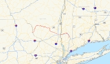
New York State Route 52 (NY 52) is a 108.72 miles (174.97 km) long state highway
in the southeastern part of New York
in the United States. It generally runs from west to east, beginning at the Pennsylvania state line
in the Delaware River
near Narrowsburg
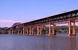
, crossing the Hudson River
on the Newburgh-Beacon Bridge
, and ending in Carmel
. Route 52 and Route 55, both major east–west routes of the Mid-Hudson Region, run parallel to each other, intersecting in downtown Liberty
.
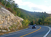
With the exception of the section overlapping Interstate 84
, most of Route 52 is a two–lane road through lightly developed rural areas. The road west of the Hudson River serves a number of small communities in the southern Catskills
, while it closely parallels I–84 east of the Hudson.
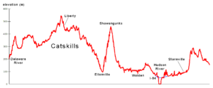 Route 52 runs through several distinct regions: the Catskills
, a lightly populated area from the Delaware River
to the Shawangunk Ridge
; a relatively flat area from the east slope of the Shawangunks through Orange County
to the Hudson River
; another flat area east of the Hudson to Stormville; and part of the Taconics
south through Kent
and Carmel
to the eastern terminus.
 Although much of its length runs through less remote territory than NY 55, at its western end it is NY 52 that lies further from New York City
. From the bridge over the Delaware River
at Narrowsburg
(where the route links to Pennsylvania Route 652 in Pennsylvania
) it joins NY 97
briefly, strikes out into the countryside trending gradually northwards, picks up NY 17B
for a short distance at Fosterdale, and it is firmly headed north.
The western half of Sullivan County
is actually less developed and populated despite its flatter topography, as the summer resort
industry Sullivan is known for was and is concentrated in the eastern towns of the county, closer to the Catskills. Much of the surrounding land is farms or woods. There is no direct trunk route for 52 to follow, and it overlaps several county roads. Some sections are maintained by the county as CR 24 (Race Course Road) from the PA line to NY 97, CR 111 (Narrowsburg Road) from NY 97 to the Cochecton town line, CR 112 (Narrowsburg Road) from the Tutsen town line to Lake Huntington, and CR 113 (Narrowsburg Road) from Lake Huntington to NY 17B & CR 114 (Newburgh Turnpike). Some older-style New York state route signs, with the "NY" on top, can be seen here.
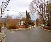
At Kenoza Lake NY 52A, 52's only suffixed subroute, goes off to the west near a historic stone bridge. A few miles later, at tiny Jeffersonville
, the only incorporated village
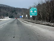
in the western half of the county, 52 finally bends back eastward. The roadway becomes smoother and its right-of-way wider. The trip through the hamlets of Youngsville and White Sulphur Springs to Liberty
passes much more quickly than the previous section.
In Liberty, the first large town along NY 52, it meets up with NY 55 and the two even share a few blocks downtown. At the village's eastern limit, it crosses the NY 17
Quickway, exactly a hundred driving miles from the city. Beyond 17, it passes some shopping plazas, then heads out into the country again along a good quality roadway, recently repaved.
Sullivan's eastern half offers the hamlets of Loch Sheldrake
and Woodbourne
, both of which bustle in the summertime, particularly with Orthodox Jews
from the city who have traditionally taken their families to the area for the summer. Sullivan County Community College
and the two nearby state prisons keep the economy going in the off-season.
NY 52 carries NY 42
over the Neversink River
, after which it leaves northward to the end of its southern segment. Just past Woodbourne Correctional Facility
, it crosses into Ulster County
. The highway from there to Ellenville
is largely a straight, gradual descent off the Catskill Plateau through primarily wooded and undeveloped land (a few buildings on either side of the road mark the hamlets of Dairyland and Greenfield Park), with the Bush Kill
coming in on the south side as the village approaches.
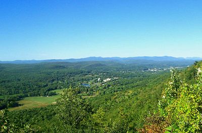
 At Ellenville's western boundary, 52 appears to split (see below). Both sections intersect with US 209 in the center of the village. Once across the village, just to the east, 52 encounters its most significant terrain feature, the Shawangunk Ridge
, which looms over the village. The highway turns abruptly southward at the village's eastern boundary and begins a gradual three-mile (4.8 km) climb up the ridge. This is a very scenic stretch of 52, as several overlook
s on the upper portions offer sweeping views of the Catskills, and closer to it there are the range's famous brilliant cliffs. The Long Path
hiking trail also leaves its aqua
-colored blazes
on a stretch of the road it shares.
At the crest, near the road to Cragsmoor
, 52 reaches nearly 1,500 feet (460 m) in elevation, turns again eastward, and begins an equally gradual descent.
. Walker Valley
is the first town encountered, at the point where the highway begins to level out again. From here several more miles of road, through more open country, brings 52 to the Shawangunk Kill
bridge and the Orange County
line.
Downtown Pine Bush
immediately presents itself, along with what was until recently the well-developed hamlet's only traffic light
, at NY 302's
northern terminus. A mile later, the hamlet ends and countryside resumes.
 There are many panoramas of the Shawangunks along the next stretch of highway, as it passes mostly open fields with a few wooded interruptions. Six miles (9.6 km) east of Pine Bush, 52 enters Walden
, the largest town on it thus far, first as North Montgomery Street. This changes to South Montgomery at the Oak Street intersection, where 52 temporarily turned on to cross the Wallkill River
at the Low Bridge from 2003–2005 while a new High Bridge (officially the Walden Veterans' Memorial Bridge
) was being built. The new bridge, where 52 becomes Main Street, crosses the river at least 50 feet (15 m) above water level and provides a view to the waterfalls and power station
just upriver.
 In downtown Walden, NY 52 meets NY 208
and overlaps it for two short blocks, before resuming its eastward course. The road ahead runs through more farmlands and woodlots, across the Catskill Aqueduct
and past the swamp
y south end of Orange Lake
. In the Town of Newburgh
, after crossing under the New York State Thruway
, residential and commercial development becomes continuous along the road. 52 intersects NY 300
in the built-up area known as Gardnertown
for an early settler, whose house
is visible from the junction, and then passes through the suburb
an area around Algonquin and Winona lakes, both fed by Orange Lake's outlet brook, before reaching I-84
.
 NY 52 and I-84 have been gradually converging for several miles at this point, and the two merge at the interstate's exit 8, just outside the Newburgh
city limits, to cross the Hudson together via the bridge. Just past the bridge's toll plaza are the ramps for NY 9D
, just on the northern line of the city of Beacon
. They will continue to run close to each other for the rest of 52's route. The concurrency lasts seven miles (11.2 km), well into Dutchess County
before 52 resumes its pre-bridge course at exit 12, becoming the main street of yet another village, Fishkill
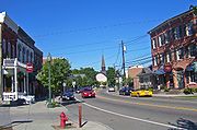
. Here it is the backbone of a historic district
. Just east of the downtown area is the major junction with US 9, and 52 through Fishkill is often heavily congested at rush hour as drivers use it as a shortcut past similarly-congested sections of I-84 from southbound 9.
 East of Route 9, there is still considerable development along the road although it opens up somewhat as it passes the southern termini of NY 376
and NY 82
, in Hopewell Junction
and Brinckerhoff
to the Taconic State Parkway
junction. Traffic lessens out past the Taconic as it is no longer a major connecting route in that direction, and after Stormville and NY 216
, 52 once again begins to feel like a country road, winding under a high bridge carrying 84 once again and crossing the Appalachian Trail
as it leaves Dutchess to enter its last county, Putnam
, at the hamlet of Ludingtonville.
 Here, it follows the eastern shore of Lake Carmel
in the community of the same name
, the most populous along its entire route. NY 311
crosses and provides a feeder route back to I-84. It continues along the lake, crossing a small inlet near its southern end, then descends through the small downtown of Lake Carmel, then reascends through the gently rolling, mostly wooded countryside. After passing a large shopping center, it enters Carmel
proper. A few blocks into downtown it reaches the eastern terminus of NY 301
at the county courthouse
, just northeast of Lake Gleneida
, a controlled lake part of New York City's water supply. A short distance past that along the lake, NY 52 ends at US 6
next to Reed Memorial Library
.
during the early 19th century. While the turnpikes made significant improvements to very poor roads, they were not popular with the public and eventually failed, leaving their roads for the county or state to maintain.
to Ellenville. After being incorporated by the New York Legislature
on April 17, 1830, it built and opened a turnpike from Ellenville on the Delaware and Hudson Canal
west to Woodbourne in 1838, and later extended it further in that direction to Liberty.
To the east of Ellenville, the Newburgh and Ellenville Plank Road Company was proposed in late 1849 to build and charge toll
s on a plank road
between Ellenville and Newburgh, major markets on the canal and Hudson respectively. It was incorporated on March 24, 1850 under the state's general incorporation law
. The company decided shortly thereafter to build on a southern route; the supporters of a northern route organized the Newburgh and Shawangunk Plank Road two weeks later. Both roads were completed in December 1851; an opening celebration for the Newburgh and Ellenville was held at Ellenville on December 22. The south route is now, with some modifications, part of Route 52, while the north route carries parts of Route 32
and Route 300
, becoming a county road (Bruyn Turnpike) west of Wallkill
. In 1895 the Walden and Orange Lake Railroad, later part of the Orange County Traction Company, built a trolley line along the old turnpike between Orange Lake
, then the end of a suburban line from Newburgh, and Walden. It carried passengers and freight, including milk, until its demise in 1925.
Other former turnpikes used by Route 52 include short lengths of the Jeffersonville and Monticello Turnpike (Jeffersonville
to Briscoe Road), Ulster and Orange Branch Turnpike (Liberty
to Cross Farm Road), Philipstown Turnpike (Pecksville to Ludingtonville), and Putnam and Dutchess Turnpike (Ludingtonville to the end in Carmel). By the 1890s, the entire route that would become Route 52 existed as public or turnpike roads.
s. In 1909, a connected network of routes was laid out by the legislature; none of the present Route 52 was included. It was also not part of the system of signed State Routes numbered in 1924. By 1926, Route 39
was signed from Poughkeepsie to Patterson, using a short piece of modern Route 52 between East Fishkill and Stormville. The rest of old Route 39 used modern NY 376 from Poughkeepsie to East Fishkill, NY 216 from Stormville to Poughquag, NY 55 from Poughquag to West Pawling, NY 292 from West Pawling to West Patterson, and NY 311 from West Patterson to Patterson
.
state line; however, it was several years before Route 52 as a whole was improved and paved. At its west end, Route 52 connected with U.S. Route 106, which had been designated in 1926 and ended at the Delaware River
on the Pennsylvania
state line. US 106 was never extended into New York, and is now Pennsylvania Route 652 near the border.
 East of East Fishkill, the newly designated Route 52 used the old alignment of 1920s Route 39 from East Fishkill to West Patterson. At West Patterson, the route continued along previously unnumbered roads south to Carmel
, then east to NY 22
at Sears Corners (northeast of Brewster
) over modern NY 311
, U.S. Route 6, and NY 312
, as well as its modern alignment from Lake Carmel
to Carmel. At the time, modern NY 52 from Stormville to Ludingtonville (northwest of Lake Carmel) was designated as part of NY 216
. NY 52 and NY 216 mostly swapped locations ca. 1937; NY 52 was rerouted onto its modern alignment between Stormville and Lake Carmel, utilizing the portion of NY 216 from Stormville and Ludingtonville as well as a new roadway between Ludingtonville and Lake Carmel while NY 216 was relocated to the old Route 39 alignment (Stormville-Poughquag-West Patterson). The original NY 52 segment from West Patterson to Lake Carmel was assigned as an extension of NY 311. NY 52 was also truncated to its present terminus in Carmel at this time.
on November 2, 1963. Prior to then, Route 52 had crossed the Hudson River
on the Newburgh-Beacon Ferry
, approaching from the west on Dupont Avenue and Broadway (overlapping Route 17K
on Broadway) and from the east on Fishkill Avenue and Wolcott Avenue (now mostly Route 52 Business).
Natural disasters and construction have forced temporary closures and reroutings in some areas. On December 31, 2002, a rockslide
along the stretch climbing the Shawangunks east of Ellenville
buried an 85-foot (25 m) section of the road with an estimated 1,000 cubic yards (800 m³) of rock and dirt. The state Department of Transportation
closed the road temporarily. Automobile traffic was detoured via several local roads; trucks had to make a lengthy side trip via Route 17
During the 2003–2005 construction of the new bridge over the Wallkill River
in Walden
, Route 52 was routed to Walden's other bridge (the "Low Bridge") via Oak Street, which intersects the highway twice within the village. This required the erection of two temporary traffic signals, causing some new traffic problems in the village. Truck traffic was detoured to Route 17K
via Albany Post Road and Stone Castle Road.
 The village of Walden has noted, in its 2005 Comprehensive Plan, the difficulties created by the oblique intersection at the eastern end of the Route 208 concurrency. Traffic on northbound 208 comes to a stop sign at the intersection, where 52 comes in from the right at a slightly lower grade and a sharp angle, with the view mostly blocked by a building. It is also just opposite one of two curb cuts for a busy Hess
-branded gas station. At rush hour
, the traffic light at the nearby northern end often backs cars up along 52 for some distance, making the turn into the gas station difficult, especially when vehicles on 52 make the left turn into the curb cut.
The layout of the intersection is very poor for trucks making this turn, and the congestion all these factors create has been forcing more drivers to resort to side streets, the village believes, since traffic counts
have been going up on 52 and 208 but down on the concurrency. It is hoping to work with the state DOT on marking an alternate route for trucks.
 Across Ellenville, both Center and Canal streets carry NY 52 shields and reference markers as they run parallel across the village. While the New York State Department of Transportation
(NYSDOT) does not list a separate reference route in the village, a 2005 Ulster County Transportation Council map shows both as state highways.
Some of NYSDOT's own documents suggest as well that 52 divides into two two-way routes in Ellenville. An DOT-produced quadrangle map shows the designation applying to both streets. State traffic signal regulations make reference to both Canal and Center being part of Route 52, and the National Bridge Inventory
lists two bridges over Sandburg Creek along Route 52 in the village.
 Since Canal has a stop sign at its western junction with Center, and Center at the eastern fork, this results in each street being the optimum route across the village depending on the direction of travel. When coming from the west, taking the fork onto Canal at the western boundary allows a driver to build up speed before beginning the climb up the Shawangunks. Conversely, quickly bearing onto Center at the end of that climb means not having to stop at the fork on the other side of the village.
with some trees and telephone on it. East of Woodruff Street, the older road functions as a service road
for the residents and businesses in that area, mostly on the north side as the south side is a village park. The former right-of-way visibly continues to Highland Avenue although most of it has been revegetated.
 NY 52A (2.78 miles or 4.47 km) is an alternate route of NY 52 through western Sullivan County
. The route begins at NY 17B
near the hamlet of Fosterdale and continues north and east to its terminus at NY 52 near the north end of Kenoza Lake, where a historic and picturesque stone arch bridge is visible from the junction. It serves mainly to shorten the trip from Callicoon to Liberty
via NY 52 as without it drivers on NY 17B
would have to go out of their way to reach the junction. The route was assigned as part of the 1930 renumbering of state highways in New York.
of NY 52 that extends for 4.74 miles (7.63 km) through the city of Beacon
in Dutchess County, New York
. The route is signed as east–west, starting at Interstate 84 / NY 52 exit 11 and NY 9D
north of Beacon and ending at I-84 / NY 52 exit 12 southwest of the village of Fishkill
, where NY 52 leaves I-84, ending the I-84 / NY 52 concurrency. NY 52 Business is not posted on guide signs on I-84.
NY 52 Business begins at I-84 / NY 52 exit 11 and runs concurrent
with NY 9D into Beacon. At Main Street, NY 52 Business leaves NY 9D and follows Main Street east through the Lower Main Street Historic District and across town to Fishkill Avenue. The route turns left onto that street, following Fishkill Avenue out of the city. At Prospect Street, a local road straddling the Beacon city line, NY 52 Business becomes state-maintained as NY 980J, an unsigned reference route.
After Millholland Drive, Fishkill Avenue becomes Main Street once again, this time for Fishkill, before meeting I-84 / NY 52. At the interchange, NY 52 Business, as well as the NY 980J designation, comes to an end while NY 52 continues east along Main Street.
|rowspan=2|
|rowspan=2|81.62
|rowspan=2 colspan=2 align="center"|Newburgh-Beacon Bridge
over the Hudson River
|-
|rowspan=8|Dutchess
State highway
State highway, state road or state route can refer to one of three related concepts, two of them related to a state or provincial government in a country that is divided into states or provinces :#A...
in the southeastern part of New York
New York
New York is a state in the Northeastern region of the United States. It is the nation's third most populous state. New York is bordered by New Jersey and Pennsylvania to the south, and by Connecticut, Massachusetts and Vermont to the east...
in the United States. It generally runs from west to east, beginning at the Pennsylvania state line
New York - Pennsylvania Border
The New York–Pennsylvania border is the state line between the U.S. states of New York and Pennsylvania. It has three sections:* along the center line of the Delaware River from the tri-point with New Jersey at the confluence of the Delaware with the Neversink River in Port Jervis, New York to the...
in the Delaware River
Delaware River
The Delaware River is a major river on the Atlantic coast of the United States.A Dutch expedition led by Henry Hudson in 1609 first mapped the river. The river was christened the South River in the New Netherland colony that followed, in contrast to the North River, as the Hudson River was then...
near Narrowsburg
Narrowsburg, New York
Narrowsburg is a hamlet in Sullivan County, New York, United States. The population was 414 at the 2000 census.Narrowsburg is in the western part of the Town of Tusten at the junction of Routes 52 and 97...
, crossing the Hudson River
Hudson River
The Hudson is a river that flows from north to south through eastern New York. The highest official source is at Lake Tear of the Clouds, on the slopes of Mount Marcy in the Adirondack Mountains. The river itself officially begins in Henderson Lake in Newcomb, New York...
on the Newburgh-Beacon Bridge
Newburgh-Beacon Bridge
The Newburgh–Beacon Bridge, is a cantilever toll bridge that spans the Hudson River in New York State carrying NY 52 and Interstate 84 between Newburgh and Beacon...
, and ending in Carmel
Carmel, New York
Carmel is a town located in Putnam County, New York, USA. As of the 2000 census, the town had a total population of 36,465.There are no incorporated villages in the town, although the hamlets of Carmel and Mahopac each have populations sizable enough to be thought of as villages.The Town of Carmel...
. Route 52 and Route 55, both major east–west routes of the Mid-Hudson Region, run parallel to each other, intersecting in downtown Liberty
Liberty (village), New York
Liberty is a village in Sullivan County, New York, United States. The population was 3,975 at the 2000 census.The Village of Liberty is centrally located in the Town of Liberty and is adjacent to New York Route 17.- History :...
.
With the exception of the section overlapping Interstate 84
Interstate 84 in New York
Interstate 84 is a part of the Interstate Highway System that runs from Dunmore, Pennsylvania, to Sturbridge, Massachusetts, in the Eastern United States. In New York, I-84 extends from the Pennsylvania state line at Port Jervis to the Connecticut state line east of Brewster...
, most of Route 52 is a two–lane road through lightly developed rural areas. The road west of the Hudson River serves a number of small communities in the southern Catskills
Catskill Mountains
The Catskill Mountains, an area in New York State northwest of New York City and southwest of Albany, are a mature dissected plateau, an uplifted region that was subsequently eroded into sharp relief. They are an eastward continuation, and the highest representation, of the Allegheny Plateau...
, while it closely parallels I–84 east of the Hudson.
Route description
Catskill Mountains
The Catskill Mountains, an area in New York State northwest of New York City and southwest of Albany, are a mature dissected plateau, an uplifted region that was subsequently eroded into sharp relief. They are an eastward continuation, and the highest representation, of the Allegheny Plateau...
, a lightly populated area from the Delaware River
Delaware River
The Delaware River is a major river on the Atlantic coast of the United States.A Dutch expedition led by Henry Hudson in 1609 first mapped the river. The river was christened the South River in the New Netherland colony that followed, in contrast to the North River, as the Hudson River was then...
to the Shawangunk Ridge
Shawangunk Ridge
The Shawangunk Ridge , also known as the Shawangunk Mountains or The Gunks, is a ridge of bedrock in Ulster County, Sullivan County and Orange County in the state of New York, extending from the northernmost point of New Jersey to the Catskill Mountains.The ridgetop, which widens considerably at...
; a relatively flat area from the east slope of the Shawangunks through Orange County
Orange County, New York
Orange County is a county located in the U.S. state of New York. It is part of the Poughkeepsie–Newburgh–Middletown, NY Metropolitan Statistical Area and is located at the northern reaches of the New York metropolitan area. The county sits in the state's scenic Mid-Hudson Region of the Hudson Valley...
to the Hudson River
Hudson River
The Hudson is a river that flows from north to south through eastern New York. The highest official source is at Lake Tear of the Clouds, on the slopes of Mount Marcy in the Adirondack Mountains. The river itself officially begins in Henderson Lake in Newcomb, New York...
; another flat area east of the Hudson to Stormville; and part of the Taconics
Taconic Mountains
The Taconic Mountains or Taconic Range are a physiographic section of the larger New England province and part of the Appalachian Mountains, running along the eastern border of New York State and adjacent New England from northwest Connecticut to western Massachusetts, north to central western...
south through Kent
Kent, New York
Kent is a town in Putnam County, New York, United States. The population was 14,009 at the 2000 census. The name is that of an early settler family. The town is the north-central part of the Putnam County. Many of the lakes are reservoirs for New York City....
and Carmel
Carmel, New York
Carmel is a town located in Putnam County, New York, USA. As of the 2000 census, the town had a total population of 36,465.There are no incorporated villages in the town, although the hamlets of Carmel and Mahopac each have populations sizable enough to be thought of as villages.The Town of Carmel...
to the eastern terminus.
Delaware to Shawangunks
New York City
New York is the most populous city in the United States and the center of the New York Metropolitan Area, one of the most populous metropolitan areas in the world. New York exerts a significant impact upon global commerce, finance, media, art, fashion, research, technology, education, and...
. From the bridge over the Delaware River
Delaware River
The Delaware River is a major river on the Atlantic coast of the United States.A Dutch expedition led by Henry Hudson in 1609 first mapped the river. The river was christened the South River in the New Netherland colony that followed, in contrast to the North River, as the Hudson River was then...
at Narrowsburg
Narrowsburg, New York
Narrowsburg is a hamlet in Sullivan County, New York, United States. The population was 414 at the 2000 census.Narrowsburg is in the western part of the Town of Tusten at the junction of Routes 52 and 97...
(where the route links to Pennsylvania Route 652 in Pennsylvania
Pennsylvania
The Commonwealth of Pennsylvania is a U.S. state that is located in the Northeastern and Mid-Atlantic regions of the United States. The state borders Delaware and Maryland to the south, West Virginia to the southwest, Ohio to the west, New York and Ontario, Canada, to the north, and New Jersey to...
) it joins NY 97
New York State Route 97
New York State Route 97 is a north–south scenic route in southern New York, United States. It runs from U.S. Route 6 and US 209 in Port Jervis to NY 17 in Hancock. Its most famous feature is the Hawk's Nest, a tightly winding section of the road along the Delaware River,...
briefly, strikes out into the countryside trending gradually northwards, picks up NY 17B
New York State Route 17B
New York State Route 17B is a state highway located entirely within Sullivan County, New York. It connects the hamlet of Callicoon at its western end with the Monticello area in the east .-Route description:From its terminus at NY 97 in the hamlet of Callicoon New York State...
for a short distance at Fosterdale, and it is firmly headed north.
The western half of Sullivan County
Sullivan County, New York
Sullivan County is a county located in the U.S. state of New York. As of the 2010 census, the population was 77,547. The county seat is Monticello. The name is in honor of Major General John Sullivan, who was a hero in the American Revolutionary War...
is actually less developed and populated despite its flatter topography, as the summer resort
Resort
A resort is a place used for relaxation or recreation, attracting visitors for holidays or vacations. Resorts are places, towns or sometimes commercial establishment operated by a single company....
industry Sullivan is known for was and is concentrated in the eastern towns of the county, closer to the Catskills. Much of the surrounding land is farms or woods. There is no direct trunk route for 52 to follow, and it overlaps several county roads. Some sections are maintained by the county as CR 24 (Race Course Road) from the PA line to NY 97, CR 111 (Narrowsburg Road) from NY 97 to the Cochecton town line, CR 112 (Narrowsburg Road) from the Tutsen town line to Lake Huntington, and CR 113 (Narrowsburg Road) from Lake Huntington to NY 17B & CR 114 (Newburgh Turnpike). Some older-style New York state route signs, with the "NY" on top, can be seen here.
At Kenoza Lake NY 52A, 52's only suffixed subroute, goes off to the west near a historic stone bridge. A few miles later, at tiny Jeffersonville
Jeffersonville, New York
Jeffersonville is a village in Sullivan County, New York, United States. The population was 420 at the 2000 census. The name is derived indirectly from Thomas Jefferson....
, the only incorporated village
Village
A village is a clustered human settlement or community, larger than a hamlet with the population ranging from a few hundred to a few thousand , Though often located in rural areas, the term urban village is also applied to certain urban neighbourhoods, such as the West Village in Manhattan, New...
in the western half of the county, 52 finally bends back eastward. The roadway becomes smoother and its right-of-way wider. The trip through the hamlets of Youngsville and White Sulphur Springs to Liberty
Liberty (village), New York
Liberty is a village in Sullivan County, New York, United States. The population was 3,975 at the 2000 census.The Village of Liberty is centrally located in the Town of Liberty and is adjacent to New York Route 17.- History :...
passes much more quickly than the previous section.
In Liberty, the first large town along NY 52, it meets up with NY 55 and the two even share a few blocks downtown. At the village's eastern limit, it crosses the NY 17
New York State Route 17
New York State Route 17 is a state highway that extends for through the Southern Tier and Downstate regions of New York in the United States...
Quickway, exactly a hundred driving miles from the city. Beyond 17, it passes some shopping plazas, then heads out into the country again along a good quality roadway, recently repaved.
Sullivan's eastern half offers the hamlets of Loch Sheldrake
Loch Sheldrake, New York
Loch Sheldrake is a hamlet in the Town of Fallsburg, New York in Sullivan County, New York. The zipcode for Loch Sheldrake is 12759.The community was originally named Sheldrake Pond after a deep glacially formed pond which forms the center of town...
and Woodbourne
Woodbourne, New York
Woodbourne is a hamlet in the town of Fallsburg in Sullivan County, New York, United States.Woodbourne is bordered by the town of Neversink, the hamlet of Grahamsville, the hamlet of Loch Sheldrake, the hamlet of Old Falls, and the hamlet of Hasbrouck. The major thoroughfares of Woodbourne are New...
, both of which bustle in the summertime, particularly with Orthodox Jews
Orthodox Judaism
Orthodox Judaism , is the approach to Judaism which adheres to the traditional interpretation and application of the laws and ethics of the Torah as legislated in the Talmudic texts by the Sanhedrin and subsequently developed and applied by the later authorities known as the Gaonim, Rishonim, and...
from the city who have traditionally taken their families to the area for the summer. Sullivan County Community College
Sullivan County Community College
Founded in 1962, Sullivan County Community College ' is a two-year public community college sponsored by the State University of New York SUNY and Sullivan County, New York. It is also fully accredited by the Middle States Association of Colleges and Schools...
and the two nearby state prisons keep the economy going in the off-season.
NY 52 carries NY 42
New York State Route 42
New York State Route 42 is a north–south, discontinuous state highway in the Catskill Mountains region of New York in the United States. The southernmost of the highway's two segments begins at an intersection with U.S. Route 6 and US 209 in Port Jervis and ends at a junction with...
over the Neversink River
Neversink River
The Neversink River is a tributary of the Delaware River in southeastern New York in the United States...
, after which it leaves northward to the end of its southern segment. Just past Woodbourne Correctional Facility
Woodbourne Correctional Facility
Woodbourne Correctional Facility is a medium security men's prison operated by the New York State Department of Correctional Services in Woodbourne, New York of Sullivan County...
, it crosses into Ulster County
Ulster County, New York
Ulster County is a county located in the state of New York, USA. It sits in the state's Mid-Hudson Region of the Hudson Valley. As of the 2010 census, the population was 182,493. Recent population estimates completed by the United States Census Bureau for the 12-month period ending July 1 are at...
. The highway from there to Ellenville
Ellenville, New York
Ellenville is a village in Ulster County, New York, United States. The population was 4,135 at the 2010 census. The postal ZIP code is 12428. The telephone exchange is predominantly 647 and an overlaid 210 in the 845 area code.- Geography :...
is largely a straight, gradual descent off the Catskill Plateau through primarily wooded and undeveloped land (a few buildings on either side of the road mark the hamlets of Dairyland and Greenfield Park), with the Bush Kill
Big Bushkill Creek
Big Bushkill Creek is a tributary of the Delaware River in the Poconos of eastern Pennsylvania in the United States....
coming in on the south side as the village approaches.
Shawangunk Ridge
The Shawangunk Ridge , also known as the Shawangunk Mountains or The Gunks, is a ridge of bedrock in Ulster County, Sullivan County and Orange County in the state of New York, extending from the northernmost point of New Jersey to the Catskill Mountains.The ridgetop, which widens considerably at...
, which looms over the village. The highway turns abruptly southward at the village's eastern boundary and begins a gradual three-mile (4.8 km) climb up the ridge. This is a very scenic stretch of 52, as several overlook
Overlook
A scenic overlook, or just an overlook, observation point, lookout or viewing point, is a high place where people can gather to view scenery , and to photograph it. Scenic overlooks are typically created alongside mountain roads, often as a simple turnouts where motorists can pull over onto...
s on the upper portions offer sweeping views of the Catskills, and closer to it there are the range's famous brilliant cliffs. The Long Path
Long Path
The Long Path is a long-distance hiking trail beginning at the George Washington Bridge in Fort Lee, New Jersey and currently ending at Altamont, New York, in the Albany area...
hiking trail also leaves its aqua
Aquamarine (color)
Aquamarine is a color that is a pale bright tint of spring green toned toward cyan. It is named after the mineral aquamarine, a gemstone mainly found in granite rocks...
-colored blazes
Trail blazing
Trail blazing, or trailblazing, is the practice of marking paths in outdoor recreational areas with blazes, markings that follow each other at certain — though not necessarily exactly defined — distances and mark the direction of the trail...
on a stretch of the road it shares.
At the crest, near the road to Cragsmoor
Cragsmoor, New York
Cragsmoor is a hamlet in Ulster County, New York, United States. The population was 449 at the 2000 census.Cragsmoor is located atop the Shawangunk Ridge, in the south part of the Town of Wawarsing...
, 52 reaches nearly 1,500 feet (460 m) in elevation, turns again eastward, and begins an equally gradual descent.
Shawangunks to Hudson River
The wooded route down the east side of the Shawangunks offers its own vistas of the land ahead—at one point, on clear days, it is possible to see all the way to the Hudson HighlandsHudson Highlands
The Hudson Highlands are mountains on both sides of the Hudson River in the U.S. state of New York, between Newburgh Bay and Haverstraw Bay, which form the northern region of the New York - New Jersey Highlands....
. Walker Valley
Walker Valley, New York
Walker Valley is a hamlet located in the western part of the Town of Shawangunk in Ulster County, New York, U.S., generally thought of as coterminous with the 12588 ZIP code. The population was 758 at the 2000 census....
is the first town encountered, at the point where the highway begins to level out again. From here several more miles of road, through more open country, brings 52 to the Shawangunk Kill
Shawangunk Kill
The Shawangunk Kill is a stream that flows northward through Orange, Sullivan and Ulster counties, New York, in the United States. It is the largest tributary of the Wallkill River....
bridge and the Orange County
Orange County, New York
Orange County is a county located in the U.S. state of New York. It is part of the Poughkeepsie–Newburgh–Middletown, NY Metropolitan Statistical Area and is located at the northern reaches of the New York metropolitan area. The county sits in the state's scenic Mid-Hudson Region of the Hudson Valley...
line.
Downtown Pine Bush
Pine Bush, New York
Pine Bush is a hamlet located in the Town of Crawford, and Shawangunk, New York, in Orange/Ulster Counties, New York, U.S., roughly coterminous with the 12566 ZIP code and 744 telephone exchange in the 845 area code Pine Bush is a hamlet (and census-designated place) located in the Town of...
immediately presents itself, along with what was until recently the well-developed hamlet's only traffic light
Traffic light
Traffic lights, which may also be known as stoplights, traffic lamps, traffic signals, signal lights, robots or semaphore, are signalling devices positioned at road intersections, pedestrian crossings and other locations to control competing flows of traffic...
, at NY 302's
New York State Route 302
New York State Route 302 is a state highway in northern Orange County, New York, United States. The southern terminus of the route is at an intersection with NY 17M north of the city of Middletown...
northern terminus. A mile later, the hamlet ends and countryside resumes.
Walden, New York
Walden is the largest of three villages of the Town of Montgomery in Orange County, New York, United States. The population was 6,978 at the 2010 census. It has the ZIP Code 12586 and the 778 telephone exchange within the 845 area code...
, the largest town on it thus far, first as North Montgomery Street. This changes to South Montgomery at the Oak Street intersection, where 52 temporarily turned on to cross the Wallkill River
Wallkill River
The Wallkill River, a tributary of the Hudson, drains Lake Mohawk in Sparta, New Jersey, flowing from there generally northeasterly to Rondout Creek in New York, near Rosendale, with the combined flows reaching the Hudson at Kingston....
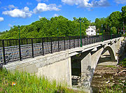
at the Low Bridge from 2003–2005 while a new High Bridge (officially the Walden Veterans' Memorial Bridge
Walden Veterans' Memorial Bridge
The Walden Veterans' Memorial Bridge, sometimes referred as the Walden High Bridge, from its predecessor, carries NY 52 over the Wallkill River in the Orange County village of Walden, New York, USA...
) was being built. The new bridge, where 52 becomes Main Street, crosses the river at least 50 feet (15 m) above water level and provides a view to the waterfalls and power station
Hydroelectricity
Hydroelectricity is the term referring to electricity generated by hydropower; the production of electrical power through the use of the gravitational force of falling or flowing water. It is the most widely used form of renewable energy...
just upriver.
New York State Route 208
New York State Route 208 is a state highway located in southern New York in the United States. The southern terminus is at an intersection with NY 17M in the Orange County village of Monroe...
and overlaps it for two short blocks, before resuming its eastward course. The road ahead runs through more farmlands and woodlots, across the Catskill Aqueduct
Catskill Aqueduct
The Catskill Aqueduct, part of the New York City water supply system, brings water from the Catskill Mountains to Yonkers where it connects to other parts of the system.-History:Construction commenced in 1907...
and past the swamp
Swamp
A swamp is a wetland with some flooding of large areas of land by shallow bodies of water. A swamp generally has a large number of hammocks, or dry-land protrusions, covered by aquatic vegetation, or vegetation that tolerates periodical inundation. The two main types of swamp are "true" or swamp...
y south end of Orange Lake
Orange Lake, New York
Orange Lake is a hamlet in Orange County, New York, United States. The population was 6,085 at the 2000 census. Newburgh–Middletown, NY Metropolitan Statistical Area as well as the larger New York–Newark–Bridgeport, NY-NJ-CT-PA Combined Statistical Area.The community of Orange...
. In the Town of Newburgh
Newburgh (town), New York
Newburgh is a town in Orange County, New York, United States. The 2010 census determined the population is 29,801. This is the first time ever that the population of the Town of Newburgh officially exceeded that of the adjacent but totally separate municipality known as the city of Newburgh...
, after crossing under the New York State Thruway
New York State Thruway
The New York State Thruway is a system of limited-access highways located within the state of New York in the United States. The system, known officially as the Governor Thomas E. Dewey Thruway for former New York Governor Thomas E. Dewey, is operated by the New York State Thruway Authority and...
, residential and commercial development becomes continuous along the road. 52 intersects NY 300
New York State Route 300
New York State Route 300 is a state highway located west of the city of Newburgh in the Hudson Valley of New York in the United States. The southern terminus of the route is at a five-way intersection with NY 32 and NY 94 in the hamlet of Vails Gate...
in the built-up area known as Gardnertown
Gardnertown, New York
Gardnertown is a hamlet in Orange County, New York, United States. The population was 4,533 at the 2000 census. It is part of the Poughkeepsie–Newburgh–Middletown, NY Metropolitan Statistical Area as well as the larger New York–Newark–Bridgeport, NY-NJ-CT-PA Combined...
for an early settler, whose house
Silas Gardner House
The Silas Gardner House is a colonial stone house at the junction of routes 52 and 300 in the Gardnertown section of the Town of Newburgh in Orange County, New York. It has been listed on the National Register of Historic Places since 1980....
is visible from the junction, and then passes through the suburb
Suburb
The word suburb mostly refers to a residential area, either existing as part of a city or as a separate residential community within commuting distance of a city . Some suburbs have a degree of administrative autonomy, and most have lower population density than inner city neighborhoods...
an area around Algonquin and Winona lakes, both fed by Orange Lake's outlet brook, before reaching I-84
Interstate 84 in New York
Interstate 84 is a part of the Interstate Highway System that runs from Dunmore, Pennsylvania, to Sturbridge, Massachusetts, in the Eastern United States. In New York, I-84 extends from the Pennsylvania state line at Port Jervis to the Connecticut state line east of Brewster...
.
Hudson River to Carmel
Newburgh (city), New York
Newburgh is a city located in Orange County, New York, United States, north of New York City, and south of Albany, on the Hudson River. Newburgh is a principal city of the Poughkeepsie-Newburgh-Middletown metropolitan area, which includes all of Dutchess and Orange counties. The Newburgh area was...
city limits, to cross the Hudson together via the bridge. Just past the bridge's toll plaza are the ramps for NY 9D
New York State Route 9D
New York State Route 9D , also known as the Bear Mountain – Beacon Highway, is a north–south state highway that runs along the eastern shore of the Hudson River in New York in the United States. It starts at the eastern end of the Bear Mountain Bridge at U.S...
, just on the northern line of the city of Beacon
Beacon, New York
Beacon is a city located in Dutchess County, New York, United States. The 2010 census placed the city total population at 15,541. Beacon is part of the Poughkeepsie–Newburgh–Middletown, NY Metropolitan Statistical Area as well as the larger New York–Newark–Bridgeport,...
. They will continue to run close to each other for the rest of 52's route. The concurrency lasts seven miles (11.2 km), well into Dutchess County
Dutchess County, New York
Dutchess County is a county located in the U.S. state of New York, in the state's Mid-Hudson Region of the Hudson Valley. The 2010 census lists the population as 297,488...
before 52 resumes its pre-bridge course at exit 12, becoming the main street of yet another village, Fishkill
Fishkill, New York
Fishkill is an upscale village within the much larger town, Town of Fishkill, one of the fastest growing towns in the region, in Dutchess County, New York, USA. The village population was 1,735 at the 2000 census...
. Here it is the backbone of a historic district
Fishkill Village District
The Fishkill Village District is a federally recognized historic district in that New York community. It is roughly defined as Main Street between Cary and Hopewell streets. Of the 108 buildings within it, those that are contributing properties date from between the late 18th century to the late...
. Just east of the downtown area is the major junction with US 9, and 52 through Fishkill is often heavily congested at rush hour as drivers use it as a shortcut past similarly-congested sections of I-84 from southbound 9.
New York State Route 376
New York State Route 376 is a state highway located entirely within Dutchess County in the Hudson Valley region of New York, United States. The route begins at an intersection with NY 52 in East Fishkill and passes north through Hopewell Junction and Red Oaks Mill on its way to the city...
and NY 82
New York State Route 82
New York State Route 82 is a state highway in the eastern Hudson Valley of New York, United States. It begins at an intersection with NY 52 northeast of the village of Fishkill, bends eastward towards Millbrook, and then returns westward to end at a junction with U.S. Route 9,...
, in Hopewell Junction
Hopewell Junction, New York
Hopewell Junction is a hamlet in Dutchess County, New York, United States. The population was 2,610 at the 2000 census...
and Brinckerhoff
Brinckerhoff, New York
Brinckerhoff is a hamlet in Dutchess County, New York, United States. The population was 2,734 at the 2000 census...
to the Taconic State Parkway
Taconic State Parkway
The Taconic State Parkway , is a divided highway between Kensico Dam and Chatham, the longest parkway in the U.S. state of New York. It follows a generally northward route midway between the Hudson River and the Connecticut and Massachusetts state lines...
junction. Traffic lessens out past the Taconic as it is no longer a major connecting route in that direction, and after Stormville and NY 216
New York State Route 216
New York State Route 216 is a short state highway located entirely in Dutchess County, New York, United States. At in length, it connects NY 52 and NY 55 between the hamlets of Stormville at the east end and Poughquag at the west...
, 52 once again begins to feel like a country road, winding under a high bridge carrying 84 once again and crossing the Appalachian Trail
Appalachian Trail
The Appalachian National Scenic Trail, generally known as the Appalachian Trail or simply the AT, is a marked hiking trail in the eastern United States extending between Springer Mountain in Georgia and Mount Katahdin in Maine. It is approximately long...
as it leaves Dutchess to enter its last county, Putnam
Putnam County, New York
Putnam County is a county located in the U.S. state of New York, in the lower Hudson River Valley. Putnam county formed in 1812, when it detached from Dutchess County. , the population was 99,710. It is part of the New York Metropolitan Area. The county seat is the hamlet of Carmel...
, at the hamlet of Ludingtonville.
Lake Carmel (New York)
Lake Carmel is located in the Town of Kent, New York, United States. It takes its name from nearby Carmel, and in turn the community surrounding the lake, which accounts for much of Kent's population, is named for it....
in the community of the same name
Lake Carmel, New York
Lake Carmel is a hamlet located in the Town of Kent in Putnam County, New York. As of the 2000 census, the population was 8,663....
, the most populous along its entire route. NY 311
New York State Route 311
New York State Route 311 is a state highway located entirely within Putnam County, New York, United States. The highway begins at NY 52 in Lake Carmel, and intersects Interstate 84 shortly thereafter...
crosses and provides a feeder route back to I-84. It continues along the lake, crossing a small inlet near its southern end, then descends through the small downtown of Lake Carmel, then reascends through the gently rolling, mostly wooded countryside. After passing a large shopping center, it enters Carmel
Carmel Hamlet, New York
Carmel Hamlet is the seat of Putnam County, New York, United States. It is a hamlet located in the Town of Carmel. As of the 2000 census, the population was 5,650....
proper. A few blocks into downtown it reaches the eastern terminus of NY 301
New York State Route 301
New York State Route 301 is an intra-county state highway stretching across three-quarters of Putnam County, New York, in the United States. The western terminus of NY 301 is at an intersection with NY 9D in Cold Spring. Its eastern terminus is at a junction with NY 52 in...
at the county courthouse
Putnam County Courthouse (New York)
New York's Putnam County Courthouse is located on Gleneida Avenue across from the eastern terminus of NY 301 in downtown Carmel, the county seat, overlooking Lake Gleneida. First built in 1814, two years after the county itself was established, it is the second-oldest county courthouse still in...
, just northeast of Lake Gleneida
Lake Gleneida
Lake Gleneida is a controlled lake in Carmel, New York, United States. It is part of New York City's water supply system, created when an original pond was dammed in 1870.-Geography:...
, a controlled lake part of New York City's water supply. A short distance past that along the lake, NY 52 ends at US 6
U.S. Route 6 in New York
U.S. Route 6 is a part of the U.S. Highway System that runs from Bishop, California, to Provincetown, Massachusetts. In New York, US 6 extends from the Pennsylvania state line at Port Jervis to the Connecticut state line east of Brewster...
next to Reed Memorial Library
Reed Memorial Library
Reed Memorial Library is located at the junction of US 6 and NY 52 in Carmel, New York, United States. It is the oldest library building in Putnam County, and was listed on the National Register of Historic Places in 1980....
.
History
Like many state highways in the region, Route 52 follows a number of roads originally built as private turnpikesToll road
A toll road is a privately or publicly built road for which a driver pays a toll for use. Structures for which tolls are charged include toll bridges and toll tunnels. Non-toll roads are financed using other sources of revenue, most typically fuel tax or general tax funds...
during the early 19th century. While the turnpikes made significant improvements to very poor roads, they were not popular with the public and eventually failed, leaving their roads for the county or state to maintain.
Predecessor turnpikes
One of these - the Woodbourne and Ellenville Turnpike Company - ran from WoodbourneWoodbourne, New York
Woodbourne is a hamlet in the town of Fallsburg in Sullivan County, New York, United States.Woodbourne is bordered by the town of Neversink, the hamlet of Grahamsville, the hamlet of Loch Sheldrake, the hamlet of Old Falls, and the hamlet of Hasbrouck. The major thoroughfares of Woodbourne are New...
to Ellenville. After being incorporated by the New York Legislature
New York Legislature
The New York State Legislature is the term often used to refer to the two houses that act as the state legislature of the U.S. state of New York. The New York Constitution does not designate an official term for the two houses together...
on April 17, 1830, it built and opened a turnpike from Ellenville on the Delaware and Hudson Canal
Delaware and Hudson Canal
The Delaware and Hudson Canal was the first venture of the Delaware and Hudson Canal Company, which later developed the Delaware and Hudson Railway...
west to Woodbourne in 1838, and later extended it further in that direction to Liberty.
To the east of Ellenville, the Newburgh and Ellenville Plank Road Company was proposed in late 1849 to build and charge toll
Toll road
A toll road is a privately or publicly built road for which a driver pays a toll for use. Structures for which tolls are charged include toll bridges and toll tunnels. Non-toll roads are financed using other sources of revenue, most typically fuel tax or general tax funds...
s on a plank road
Plank road
A plank road or puncheon is a dirt path or road covered with a series of planks, similar to the wooden sidewalks one would see in a Western movie. Plank roads were very popular in Ontario, the U.S. Northeast and U.S. Midwest in the first half of the 19th century...
between Ellenville and Newburgh, major markets on the canal and Hudson respectively. It was incorporated on March 24, 1850 under the state's general incorporation law
General incorporation law
A general incorporation law allows corporations to be formed without a charter from the legislature. It also refers to a law enabling a certain type of corporation, such as a railroad, to exercise eminent domain and other special rights without a charter from the legislature.-United States:In 1795,...
. The company decided shortly thereafter to build on a southern route; the supporters of a northern route organized the Newburgh and Shawangunk Plank Road two weeks later. Both roads were completed in December 1851; an opening celebration for the Newburgh and Ellenville was held at Ellenville on December 22. The south route is now, with some modifications, part of Route 52, while the north route carries parts of Route 32
New York State Route 32
New York State Route 32 is a north–south state highway that extends for through the Hudson Valley and Capital District regions of the U.S. state of New York. It is a two-lane surface road for nearly its entire length, with few divided and no limited-access sections. From Harriman to Albany,...
and Route 300
New York State Route 300
New York State Route 300 is a state highway located west of the city of Newburgh in the Hudson Valley of New York in the United States. The southern terminus of the route is at a five-way intersection with NY 32 and NY 94 in the hamlet of Vails Gate...
, becoming a county road (Bruyn Turnpike) west of Wallkill
Wallkill, Ulster County, New York
Wallkill is a hamlet , generally identified as coterminous with ZIP code 12589, telephone exchange 895 in the 845 area code and most of the Wallkill Central School District located mostly in the eastern half of the Town of Shawangunk, Ulster County, New York but partly spilling over into adjacent...
. In 1895 the Walden and Orange Lake Railroad, later part of the Orange County Traction Company, built a trolley line along the old turnpike between Orange Lake
Orange Lake, New York
Orange Lake is a hamlet in Orange County, New York, United States. The population was 6,085 at the 2000 census. Newburgh–Middletown, NY Metropolitan Statistical Area as well as the larger New York–Newark–Bridgeport, NY-NJ-CT-PA Combined Statistical Area.The community of Orange...
, then the end of a suburban line from Newburgh, and Walden. It carried passengers and freight, including milk, until its demise in 1925.
Other former turnpikes used by Route 52 include short lengths of the Jeffersonville and Monticello Turnpike (Jeffersonville
Jeffersonville, New York
Jeffersonville is a village in Sullivan County, New York, United States. The population was 420 at the 2000 census. The name is derived indirectly from Thomas Jefferson....
to Briscoe Road), Ulster and Orange Branch Turnpike (Liberty
Liberty (village), New York
Liberty is a village in Sullivan County, New York, United States. The population was 3,975 at the 2000 census.The Village of Liberty is centrally located in the Town of Liberty and is adjacent to New York Route 17.- History :...
to Cross Farm Road), Philipstown Turnpike (Pecksville to Ludingtonville), and Putnam and Dutchess Turnpike (Ludingtonville to the end in Carmel). By the 1890s, the entire route that would become Route 52 existed as public or turnpike roads.
Public ownership
After the demise of the turnpikes, the State Commission of Highways was created by the legislature in 1898 to improve and maintain state highwayState highway
State highway, state road or state route can refer to one of three related concepts, two of them related to a state or provincial government in a country that is divided into states or provinces :#A...
s. In 1909, a connected network of routes was laid out by the legislature; none of the present Route 52 was included. It was also not part of the system of signed State Routes numbered in 1924. By 1926, Route 39
New York State Route 39 (1920s)
New York State Route 39 was a state highway in the Hudson Valley region of New York, United States. It stretched from NY 21 in the town of Poughkeepsie to NY 22 in Patterson, New York...
was signed from Poughkeepsie to Patterson, using a short piece of modern Route 52 between East Fishkill and Stormville. The rest of old Route 39 used modern NY 376 from Poughkeepsie to East Fishkill, NY 216 from Stormville to Poughquag, NY 55 from Poughquag to West Pawling, NY 292 from West Pawling to West Patterson, and NY 311 from West Patterson to Patterson
Patterson, New York
Patterson is a town in Putnam County, New York, United States. The town is in the northeast part of the county. Interstate 84 passes through the southwest part of the town. The population was 11,306 at the 2000 census. The town is named after early farmer Matthew Paterson...
.
Formal designation
Route 52 was designated as part of the 1930 renumbering of state highways in New York. West of East Fishkill, NY 52 was assigned to its current routing along a previously unnumbered road through downstate New York to the PennsylvaniaPennsylvania
The Commonwealth of Pennsylvania is a U.S. state that is located in the Northeastern and Mid-Atlantic regions of the United States. The state borders Delaware and Maryland to the south, West Virginia to the southwest, Ohio to the west, New York and Ontario, Canada, to the north, and New Jersey to...
state line; however, it was several years before Route 52 as a whole was improved and paved. At its west end, Route 52 connected with U.S. Route 106, which had been designated in 1926 and ended at the Delaware River
Delaware River
The Delaware River is a major river on the Atlantic coast of the United States.A Dutch expedition led by Henry Hudson in 1609 first mapped the river. The river was christened the South River in the New Netherland colony that followed, in contrast to the North River, as the Hudson River was then...
on the Pennsylvania
Pennsylvania
The Commonwealth of Pennsylvania is a U.S. state that is located in the Northeastern and Mid-Atlantic regions of the United States. The state borders Delaware and Maryland to the south, West Virginia to the southwest, Ohio to the west, New York and Ontario, Canada, to the north, and New Jersey to...
state line. US 106 was never extended into New York, and is now Pennsylvania Route 652 near the border.
Carmel, New York
Carmel is a town located in Putnam County, New York, USA. As of the 2000 census, the town had a total population of 36,465.There are no incorporated villages in the town, although the hamlets of Carmel and Mahopac each have populations sizable enough to be thought of as villages.The Town of Carmel...
, then east to NY 22
New York State Route 22
New York State Route 22 is a north–south state highway in eastern New York in the United States. It runs parallel to the state's eastern edge from the outskirts of New York City to a short distance south of the Canadian border. At , it is the state's longest north–south route and...
at Sears Corners (northeast of Brewster
Brewster, New York
Brewster is a village within the town of Southeast in Putnam County, New York, United States. Its population was 2,162 at the 2000 census. The village is the most densely populated portion of the town...
) over modern NY 311
New York State Route 311
New York State Route 311 is a state highway located entirely within Putnam County, New York, United States. The highway begins at NY 52 in Lake Carmel, and intersects Interstate 84 shortly thereafter...
, U.S. Route 6, and NY 312
New York State Route 312
New York State Route 312 is a short but important state highway located entirely within the town of Southeast in Putnam County, New York in the United States...
, as well as its modern alignment from Lake Carmel
Lake Carmel, New York
Lake Carmel is a hamlet located in the Town of Kent in Putnam County, New York. As of the 2000 census, the population was 8,663....
to Carmel. At the time, modern NY 52 from Stormville to Ludingtonville (northwest of Lake Carmel) was designated as part of NY 216
New York State Route 216
New York State Route 216 is a short state highway located entirely in Dutchess County, New York, United States. At in length, it connects NY 52 and NY 55 between the hamlets of Stormville at the east end and Poughquag at the west...
. NY 52 and NY 216 mostly swapped locations ca. 1937; NY 52 was rerouted onto its modern alignment between Stormville and Lake Carmel, utilizing the portion of NY 216 from Stormville and Ludingtonville as well as a new roadway between Ludingtonville and Lake Carmel while NY 216 was relocated to the old Route 39 alignment (Stormville-Poughquag-West Patterson). The original NY 52 segment from West Patterson to Lake Carmel was assigned as an extension of NY 311. NY 52 was also truncated to its present terminus in Carmel at this time.
Realignments and detours
The only major change to Route 52's routing since then came with the opening of the Newburgh-Beacon BridgeNewburgh-Beacon Bridge
The Newburgh–Beacon Bridge, is a cantilever toll bridge that spans the Hudson River in New York State carrying NY 52 and Interstate 84 between Newburgh and Beacon...
on November 2, 1963. Prior to then, Route 52 had crossed the Hudson River
Hudson River
The Hudson is a river that flows from north to south through eastern New York. The highest official source is at Lake Tear of the Clouds, on the slopes of Mount Marcy in the Adirondack Mountains. The river itself officially begins in Henderson Lake in Newcomb, New York...
on the Newburgh-Beacon Ferry
Newburgh-Beacon Ferry
The Newburgh-Beacon Ferry is a ferry service crossing the Hudson River that connects Newburgh with Beacon New York.It carries passengers between the two cities during rush hour, primarily transporting commuters from the west side of the river at Newburgh to the commuter train station on the east...
, approaching from the west on Dupont Avenue and Broadway (overlapping Route 17K
New York State Route 17K
New York State Route 17K is an east–west state highway located within Orange County, New York, in the United States. It extends for from an intersection with County Route 76 east of Bloomingburg to a junction with U.S. Route 9W midway across the city of Newburgh...
on Broadway) and from the east on Fishkill Avenue and Wolcott Avenue (now mostly Route 52 Business).
Natural disasters and construction have forced temporary closures and reroutings in some areas. On December 31, 2002, a rockslide
Rockslide
A rockslide is a type of landslide caused by rock failure in which part of the plane of failure passes through intact rock and where material collapses en masse and not in individual blocks.The mode of failure is different from that of a rock-fall....
along the stretch climbing the Shawangunks east of Ellenville
Ellenville, New York
Ellenville is a village in Ulster County, New York, United States. The population was 4,135 at the 2010 census. The postal ZIP code is 12428. The telephone exchange is predominantly 647 and an overlaid 210 in the 845 area code.- Geography :...
buried an 85-foot (25 m) section of the road with an estimated 1,000 cubic yards (800 m³) of rock and dirt. The state Department of Transportation
New York State Department of Transportation
The New York State Department of Transportation is responsible for the development and operation of highways, railroads, mass transit systems, ports, waterways and aviation facilities in the U.S...
closed the road temporarily. Automobile traffic was detoured via several local roads; trucks had to make a lengthy side trip via Route 17
New York State Route 17
New York State Route 17 is a state highway that extends for through the Southern Tier and Downstate regions of New York in the United States...
During the 2003–2005 construction of the new bridge over the Wallkill River
Wallkill River
The Wallkill River, a tributary of the Hudson, drains Lake Mohawk in Sparta, New Jersey, flowing from there generally northeasterly to Rondout Creek in New York, near Rosendale, with the combined flows reaching the Hudson at Kingston....
in Walden
Walden, New York
Walden is the largest of three villages of the Town of Montgomery in Orange County, New York, United States. The population was 6,978 at the 2010 census. It has the ZIP Code 12586 and the 778 telephone exchange within the 845 area code...
, Route 52 was routed to Walden's other bridge (the "Low Bridge") via Oak Street, which intersects the highway twice within the village. This required the erection of two temporary traffic signals, causing some new traffic problems in the village. Truck traffic was detoured to Route 17K
New York State Route 17K
New York State Route 17K is an east–west state highway located within Orange County, New York, in the United States. It extends for from an intersection with County Route 76 east of Bloomingburg to a junction with U.S. Route 9W midway across the city of Newburgh...
via Albany Post Road and Stone Castle Road.
Future
Hess Corporation
The Hess Corporation is an integrated oil company based in New York City. The company explores, produces, transports, and refines crude oil and natural gas. Vertically completing the logistical chain, about 1,360 Hess branded filling stations market gasoline to consumers in 16 states along the...
-branded gas station. At rush hour
Rush hour
A rush hour or peak hour is a part of the day during which traffic congestion on roads and crowding on public transport is at its highest. Normally, this happens twice a day—once in the morning and once in the evening, the times during when the most people commute...
, the traffic light at the nearby northern end often backs cars up along 52 for some distance, making the turn into the gas station difficult, especially when vehicles on 52 make the left turn into the curb cut.
The layout of the intersection is very poor for trucks making this turn, and the congestion all these factors create has been forcing more drivers to resort to side streets, the village believes, since traffic counts
Annual average daily traffic
Average Annual daily traffic, abbreviated AADT, is a measure used primarily in transportation planning and transportation engineering. It is the total volume of vehicle traffic of a highway or road for a year divided by 365 days. AADT is a useful and simple measurement of how busy the road is...
have been going up on 52 and 208 but down on the concurrency. It is hoping to work with the state DOT on marking an alternate route for trucks.
The Ellenville split
New York State Department of Transportation
The New York State Department of Transportation is responsible for the development and operation of highways, railroads, mass transit systems, ports, waterways and aviation facilities in the U.S...
(NYSDOT) does not list a separate reference route in the village, a 2005 Ulster County Transportation Council map shows both as state highways.
Some of NYSDOT's own documents suggest as well that 52 divides into two two-way routes in Ellenville. An DOT-produced quadrangle map shows the designation applying to both streets. State traffic signal regulations make reference to both Canal and Center being part of Route 52, and the National Bridge Inventory
National Bridge Inventory
The National Bridge Inventory is a database, compiled by the Federal Highway Administration, with information on all bridges and tunnels in the United States that have roads passing above or below. This is similar to the grade crossing identifier number database compiled by the Federal Railroad...
lists two bridges over Sandburg Creek along Route 52 in the village.
Dual roadway in Walden
From the western of the two Tin Brook crossings within the village to the eastern village line, 52 is paralleled by an older route of East Main Street that remains in use, separated by a thin medianMedian
In probability theory and statistics, a median is described as the numerical value separating the higher half of a sample, a population, or a probability distribution, from the lower half. The median of a finite list of numbers can be found by arranging all the observations from lowest value to...
with some trees and telephone on it. East of Woodruff Street, the older road functions as a service road
Frontage road
A frontage road is a non-limited access road running parallel to a higher-speed road, usually a freeway, and feeding it at appropriate points of access...
for the residents and businesses in that area, mostly on the north side as the south side is a village park. The former right-of-way visibly continues to Highland Avenue although most of it has been revegetated.
NY 52A
Sullivan County, New York
Sullivan County is a county located in the U.S. state of New York. As of the 2010 census, the population was 77,547. The county seat is Monticello. The name is in honor of Major General John Sullivan, who was a hero in the American Revolutionary War...
. The route begins at NY 17B
New York State Route 17B
New York State Route 17B is a state highway located entirely within Sullivan County, New York. It connects the hamlet of Callicoon at its western end with the Monticello area in the east .-Route description:From its terminus at NY 97 in the hamlet of Callicoon New York State...
near the hamlet of Fosterdale and continues north and east to its terminus at NY 52 near the north end of Kenoza Lake, where a historic and picturesque stone arch bridge is visible from the junction. It serves mainly to shorten the trip from Callicoon to Liberty
Liberty (village), New York
Liberty is a village in Sullivan County, New York, United States. The population was 3,975 at the 2000 census.The Village of Liberty is centrally located in the Town of Liberty and is adjacent to New York Route 17.- History :...
via NY 52 as without it drivers on NY 17B
New York State Route 17B
New York State Route 17B is a state highway located entirely within Sullivan County, New York. It connects the hamlet of Callicoon at its western end with the Monticello area in the east .-Route description:From its terminus at NY 97 in the hamlet of Callicoon New York State...
would have to go out of their way to reach the junction. The route was assigned as part of the 1930 renumbering of state highways in New York.
NY 52 Business
New York State Route 52 Business (abbreviated NY 52 Bus.) is a business routeBusiness route
A business route in the United States and Canada is a short special route connected to a parent numbered highway at its beginning, then routed through the central business district of a nearby city or town, and finally reconnecting with the same parent numbered highway again at its...
of NY 52 that extends for 4.74 miles (7.63 km) through the city of Beacon
Beacon, New York
Beacon is a city located in Dutchess County, New York, United States. The 2010 census placed the city total population at 15,541. Beacon is part of the Poughkeepsie–Newburgh–Middletown, NY Metropolitan Statistical Area as well as the larger New York–Newark–Bridgeport,...
in Dutchess County, New York
Dutchess County, New York
Dutchess County is a county located in the U.S. state of New York, in the state's Mid-Hudson Region of the Hudson Valley. The 2010 census lists the population as 297,488...
. The route is signed as east–west, starting at Interstate 84 / NY 52 exit 11 and NY 9D
New York State Route 9D
New York State Route 9D , also known as the Bear Mountain – Beacon Highway, is a north–south state highway that runs along the eastern shore of the Hudson River in New York in the United States. It starts at the eastern end of the Bear Mountain Bridge at U.S...
north of Beacon and ending at I-84 / NY 52 exit 12 southwest of the village of Fishkill
Fishkill, New York
Fishkill is an upscale village within the much larger town, Town of Fishkill, one of the fastest growing towns in the region, in Dutchess County, New York, USA. The village population was 1,735 at the 2000 census...
, where NY 52 leaves I-84, ending the I-84 / NY 52 concurrency. NY 52 Business is not posted on guide signs on I-84.
NY 52 Business begins at I-84 / NY 52 exit 11 and runs concurrent
Concurrency (road)
A concurrency, overlap, or coincidence in a road network is an instance of one physical road bearing two or more different highway, motorway, or other route numbers...
with NY 9D into Beacon. At Main Street, NY 52 Business leaves NY 9D and follows Main Street east through the Lower Main Street Historic District and across town to Fishkill Avenue. The route turns left onto that street, following Fishkill Avenue out of the city. At Prospect Street, a local road straddling the Beacon city line, NY 52 Business becomes state-maintained as NY 980J, an unsigned reference route.
After Millholland Drive, Fishkill Avenue becomes Main Street once again, this time for Fishkill, before meeting I-84 / NY 52. At the interchange, NY 52 Business, as well as the NY 980J designation, comes to an end while NY 52 continues east along Main Street.
Major intersections
|-|rowspan=2|
|rowspan=2|81.62
|rowspan=2 colspan=2 align="center"|Newburgh-Beacon Bridge
Newburgh-Beacon Bridge
The Newburgh–Beacon Bridge, is a cantilever toll bridge that spans the Hudson River in New York State carrying NY 52 and Interstate 84 between Newburgh and Beacon...
over the Hudson River
Hudson River
The Hudson is a river that flows from north to south through eastern New York. The highest official source is at Lake Tear of the Clouds, on the slopes of Mount Marcy in the Adirondack Mountains. The river itself officially begins in Henderson Lake in Newcomb, New York...
|-
|rowspan=8|Dutchess
Dutchess County, New York
Dutchess County is a county located in the U.S. state of New York, in the state's Mid-Hudson Region of the Hudson Valley. The 2010 census lists the population as 297,488...