
New York State Route 254
Encyclopedia
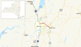
New York State Route 254 (NY 254) is a state highway
that extends for 6.01 miles (9.67 km) through Warren
and Washington Counties
in the Capital District
of New York
, United States
. The route runs from exit 19 along the Adirondack Northway (Interstate 87 or I-87) in Queensbury
and follows Aviation Road, Quaker Road, and Lower Warren Street through Queensbury to Hudson Falls
, where it terminates at an intersection with U.S. Route 4
(US 4) in the center of the village.
The portion of NY 254 along Lower Warren Street and River Street has had several designations over the years. From 1924 to 1930, it was part of the original NY 30. In 1927, it also became part of US 4, which initially overlapped NY 30 from Glens Falls to Whitehall
. In the 1930 renumbering of state highways in New York, NY 30 was reassigned elsewhere while US 4 was rerouted to bypass Glens Falls to the east. As a result, Lower Warren Street and River Street became part of NY 32B
.
The NY 32B designation remained in place until the mid-1960s when the Quaker Road arterial was built. NY 32B was partially replaced ca. 1965 by NY 254, the designation assigned to the new highway around Glens Falls. The portion of NY 254 between US 9 and Lower Warren Street is maintained by Warren County
and co-designated as County Route 47 (CR 47) and CR 70.
 NY 254 begins at the southbound ramp of Adirondack Northway (I-87
) exit 19 north of Glens Falls
in the town of Queensbury
. The route heads eastward from the interchange as Aviation Road, passing by many commercial buildings and Aviation Mall
. As it passes along the north side of the mall, NY 254 curves to the southeast before veering back to the northeast ahead of an intersection with the four-lane US 9 (Upper Glen Street). The route continues past US 9; however, maintenance of the highway is transferred from the New York State Department of Transportation
(NYSDOT) to Warren County
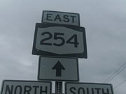
at the US 9 junction. Now co-designated as CR 47, NY 254 progresses eastward along the four-lane Quaker Road, serving as a northerly bypass of the city of Glens Falls.
As the route heads east, it passes Pine View Cemetery and several local businesses. At an intersection with Glenwood Avenue (CR 34), the county's internal designation for NY 254 becomes CR 70, whereafter the route passes over Halfway Brook and under the Gerald B. Solomon Bikeway Bridge - a part of the Warren County Bikeway. The highway progresses southeasterly upon intersecting NY 9L
as NY 254 turns due southeast to avoid Floyd Bennett Memorial Airport
. Along this stretch, NY 254 heads through undeveloped land before entering another area of commercial development as it approaches the outskirts of Hudson Falls
. Here, the route meets NY 32
at Highland Avenue before intersecting Lower Warren Street (here unsigned NY 911E) on the banks of the Hudson River
.
NY 254 turns east at NY 911E, becoming state maintained once more as it follows Lower Warren Street across the Glens Falls Feeder Canal
and along the Hudson River into Washington County
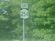
and the village of Hudson Falls
. As River Street, NY 254 heads to the southeast for a short distance before terminating at an intersection with US 4 in downtown Hudson Falls. NY 196
begins one block to the south of this junction.
 Warren Street in Glens Falls
, Lower Warren Street in Queensbury
, and River Street in Hudson Falls
were originally designated as part of NY 30 in 1924. In late 1926, the U.S. Highway System was created. One of the routes assigned at this time was US 4, which overlapped NY 30 between Glens Falls and Whitehall
. In the 1930 renumbering of state highways in New York, the NY 30 designation was reassigned elsewhere while US 4 was reconfigured to continue south from Hudson Falls to East Greenbush. The former routing of US 4 into Glens Falls became part of NY 32B
, an alternate route of NY 32
that followed the Hudson River
between Schuylerville
and Glens Falls. All of NY 32B south of Hudson Falls was concurrent to US 4.
NY 32B was truncated over time, eventually consisting of just the portion between Boulevard (then-NY 32) in Queensbury and US 4 in Hudson Falls. In the mid-1960s, a new arterial was constructed around the northern and eastern extents of Glens Falls. The roadway, designated as NY 254 ca. 1965, extended from I-87
in the north to Warren Street (NY 32B) in the south. NY 254 then continued east to US 4 in Hudson Falls, replacing NY 32B. The short 0.2 mile (0.321868 km) segment of Warren Street between NY 32 and NY 254, formerly the westernmost portion of NY 32B, is now NY 911E, an unsigned reference route.
State highway
State highway, state road or state route can refer to one of three related concepts, two of them related to a state or provincial government in a country that is divided into states or provinces :#A...
that extends for 6.01 miles (9.67 km) through Warren
Warren County, New York
Warren County is a county in the U.S. state of New York. It is part of the Glens Falls, New York, Metropolitan Statistical Area. As of the 2010 census, the population was 65,707. It is named in honor of General Joseph Warren, an American Revolutionary War hero of the Battle of Bunker Hill...
and Washington Counties
Washington County, New York
Washington County is a county located in the U.S. state of New York. It is part of the Glens Falls, New York, Metropolitan Statistical Area. As of the 2010 census, the population was 63,216. It was named for the Revolutionary War general George Washington...
in the Capital District
Capital District
New York's Capital District, also known as the Capital Region, is a region in upstate New York that generally refers to the four counties surrounding Albany, the capital of the state: Albany County, Schenectady County, Rensselaer County, and Saratoga County...
of New York
New York
New York is a state in the Northeastern region of the United States. It is the nation's third most populous state. New York is bordered by New Jersey and Pennsylvania to the south, and by Connecticut, Massachusetts and Vermont to the east...
, United States
United States
The United States of America is a federal constitutional republic comprising fifty states and a federal district...
. The route runs from exit 19 along the Adirondack Northway (Interstate 87 or I-87) in Queensbury
Queensbury, New York
Queensbury is a town in and the county seat of Warren County, New York, United States. The town is located in the southeastern part of the county. The population was 25,441 at the 2000 census. The town is named in honor of Queen Charlotte, the consort of George III of Great Britain and Ireland. It...
and follows Aviation Road, Quaker Road, and Lower Warren Street through Queensbury to Hudson Falls
Hudson Falls, New York
Hudson Falls is a village located in Washington County, New York, USA. The village is in the southwest part of the town of Kingsbury, on US Route 4. Hudson Falls is part of the Glens Falls Metropolitan Statistical Area. As of the 2000 census, the village had a population of 6,927...
, where it terminates at an intersection with U.S. Route 4
U.S. Route 4 in New York
U.S. Route 4 is a part of the U.S. Highway System that runs from East Greenbush, New York, to Portsmouth, New Hampshire. In the U.S. state of New York, US 4 extends from an intersection with US 9 and US 20 in East Greenbush to the Vermont state line northeast of Whitehall...
(US 4) in the center of the village.
The portion of NY 254 along Lower Warren Street and River Street has had several designations over the years. From 1924 to 1930, it was part of the original NY 30. In 1927, it also became part of US 4, which initially overlapped NY 30 from Glens Falls to Whitehall
Whitehall (village), New York
Whitehall is a village located in the town of Whitehall in Washington County, New York, USA. It is part of the Glens Falls Metropolitan Statistical Area...
. In the 1930 renumbering of state highways in New York, NY 30 was reassigned elsewhere while US 4 was rerouted to bypass Glens Falls to the east. As a result, Lower Warren Street and River Street became part of NY 32B
New York State Route 32B
New York State Route 32B was a state highway in the Capital District region of New York, United States. The western terminus of the route was at an intersection with NY 32 in Queensbury. Its eastern terminus was at a junction with U.S. Route 4 in Hudson Falls...
.
The NY 32B designation remained in place until the mid-1960s when the Quaker Road arterial was built. NY 32B was partially replaced ca. 1965 by NY 254, the designation assigned to the new highway around Glens Falls. The portion of NY 254 between US 9 and Lower Warren Street is maintained by Warren County
Warren County, New York
Warren County is a county in the U.S. state of New York. It is part of the Glens Falls, New York, Metropolitan Statistical Area. As of the 2010 census, the population was 65,707. It is named in honor of General Joseph Warren, an American Revolutionary War hero of the Battle of Bunker Hill...
and co-designated as County Route 47 (CR 47) and CR 70.
Route description
Interstate 87
Interstate 87 is a Interstate Highway located entirely within New York State in the United States of America. I-87 is the longest intrastate Interstate highway in the Interstate Highway System. Its southern end is at the Bronx approaches of the Robert F. Kennedy Bridge in New York City...
) exit 19 north of Glens Falls
Glens Falls, New York
Glens Falls is a city in Warren County, New York, United States. Glens Falls Metropolitan Statistical Area. The population was 14,700 at the 2010 census...
in the town of Queensbury
Queensbury, New York
Queensbury is a town in and the county seat of Warren County, New York, United States. The town is located in the southeastern part of the county. The population was 25,441 at the 2000 census. The town is named in honor of Queen Charlotte, the consort of George III of Great Britain and Ireland. It...
. The route heads eastward from the interchange as Aviation Road, passing by many commercial buildings and Aviation Mall
Aviation Mall
Aviation Mall is a major regional shopping mall in Queensbury, New York. It serves the extreme northern portion of the Capital District as well as the Glens Falls/Lake George area. The mall has a gross leasable area of...
. As it passes along the north side of the mall, NY 254 curves to the southeast before veering back to the northeast ahead of an intersection with the four-lane US 9 (Upper Glen Street). The route continues past US 9; however, maintenance of the highway is transferred from the New York State Department of Transportation
New York State Department of Transportation
The New York State Department of Transportation is responsible for the development and operation of highways, railroads, mass transit systems, ports, waterways and aviation facilities in the U.S...
(NYSDOT) to Warren County
Warren County, New York
Warren County is a county in the U.S. state of New York. It is part of the Glens Falls, New York, Metropolitan Statistical Area. As of the 2010 census, the population was 65,707. It is named in honor of General Joseph Warren, an American Revolutionary War hero of the Battle of Bunker Hill...
at the US 9 junction. Now co-designated as CR 47, NY 254 progresses eastward along the four-lane Quaker Road, serving as a northerly bypass of the city of Glens Falls.
As the route heads east, it passes Pine View Cemetery and several local businesses. At an intersection with Glenwood Avenue (CR 34), the county's internal designation for NY 254 becomes CR 70, whereafter the route passes over Halfway Brook and under the Gerald B. Solomon Bikeway Bridge - a part of the Warren County Bikeway. The highway progresses southeasterly upon intersecting NY 9L
New York State Route 9L
New York State Route 9L is a state highway in Warren County, New York, in the United States. The road is long and is a suffixed highway of U.S. Route 9 . NY 9L goes through three municipalities in Warren County: the city of Glens Falls, the town of Queensbury and the town of Lake...
as NY 254 turns due southeast to avoid Floyd Bennett Memorial Airport
Floyd Bennett Memorial Airport
Floyd Bennett Memorial Airport , formerly known as Warren County Airport, is a public airport located in the town of Queensbury three miles northeast of the city of Glens Falls in Warren County, New York, USA...
. Along this stretch, NY 254 heads through undeveloped land before entering another area of commercial development as it approaches the outskirts of Hudson Falls
Hudson Falls, New York
Hudson Falls is a village located in Washington County, New York, USA. The village is in the southwest part of the town of Kingsbury, on US Route 4. Hudson Falls is part of the Glens Falls Metropolitan Statistical Area. As of the 2000 census, the village had a population of 6,927...
. Here, the route meets NY 32
New York State Route 32
New York State Route 32 is a north–south state highway that extends for through the Hudson Valley and Capital District regions of the U.S. state of New York. It is a two-lane surface road for nearly its entire length, with few divided and no limited-access sections. From Harriman to Albany,...
at Highland Avenue before intersecting Lower Warren Street (here unsigned NY 911E) on the banks of the Hudson River
Hudson River
The Hudson is a river that flows from north to south through eastern New York. The highest official source is at Lake Tear of the Clouds, on the slopes of Mount Marcy in the Adirondack Mountains. The river itself officially begins in Henderson Lake in Newcomb, New York...
.
NY 254 turns east at NY 911E, becoming state maintained once more as it follows Lower Warren Street across the Glens Falls Feeder Canal
Glens Falls Feeder Canal
The Glens Falls Feeder Canal is a canal from Glens Falls, New York, United States through Hudson Falls and into Fort Edward. It is seven miles long and delivers water from above Glen's Falls on the Hudson River to the highest point of the Champlain Canal...
and along the Hudson River into Washington County
Washington County, New York
Washington County is a county located in the U.S. state of New York. It is part of the Glens Falls, New York, Metropolitan Statistical Area. As of the 2010 census, the population was 63,216. It was named for the Revolutionary War general George Washington...
and the village of Hudson Falls
Hudson Falls, New York
Hudson Falls is a village located in Washington County, New York, USA. The village is in the southwest part of the town of Kingsbury, on US Route 4. Hudson Falls is part of the Glens Falls Metropolitan Statistical Area. As of the 2000 census, the village had a population of 6,927...
. As River Street, NY 254 heads to the southeast for a short distance before terminating at an intersection with US 4 in downtown Hudson Falls. NY 196
New York State Route 196
New York State Route 196 is a state route in New York, running from the village of Hudson Falls east to the hamlet of South Hartford in Hartford, Washington County....
begins one block to the south of this junction.
History
Glens Falls, New York
Glens Falls is a city in Warren County, New York, United States. Glens Falls Metropolitan Statistical Area. The population was 14,700 at the 2010 census...
, Lower Warren Street in Queensbury
Queensbury, New York
Queensbury is a town in and the county seat of Warren County, New York, United States. The town is located in the southeastern part of the county. The population was 25,441 at the 2000 census. The town is named in honor of Queen Charlotte, the consort of George III of Great Britain and Ireland. It...
, and River Street in Hudson Falls
Hudson Falls, New York
Hudson Falls is a village located in Washington County, New York, USA. The village is in the southwest part of the town of Kingsbury, on US Route 4. Hudson Falls is part of the Glens Falls Metropolitan Statistical Area. As of the 2000 census, the village had a population of 6,927...
were originally designated as part of NY 30 in 1924. In late 1926, the U.S. Highway System was created. One of the routes assigned at this time was US 4, which overlapped NY 30 between Glens Falls and Whitehall
Whitehall (village), New York
Whitehall is a village located in the town of Whitehall in Washington County, New York, USA. It is part of the Glens Falls Metropolitan Statistical Area...
. In the 1930 renumbering of state highways in New York, the NY 30 designation was reassigned elsewhere while US 4 was reconfigured to continue south from Hudson Falls to East Greenbush. The former routing of US 4 into Glens Falls became part of NY 32B
New York State Route 32B
New York State Route 32B was a state highway in the Capital District region of New York, United States. The western terminus of the route was at an intersection with NY 32 in Queensbury. Its eastern terminus was at a junction with U.S. Route 4 in Hudson Falls...
, an alternate route of NY 32
New York State Route 32
New York State Route 32 is a north–south state highway that extends for through the Hudson Valley and Capital District regions of the U.S. state of New York. It is a two-lane surface road for nearly its entire length, with few divided and no limited-access sections. From Harriman to Albany,...
that followed the Hudson River
Hudson River
The Hudson is a river that flows from north to south through eastern New York. The highest official source is at Lake Tear of the Clouds, on the slopes of Mount Marcy in the Adirondack Mountains. The river itself officially begins in Henderson Lake in Newcomb, New York...
between Schuylerville
Schuylerville, New York
Schuylerville is a village in Saratoga County, New York, United States. The population was 1,197 at the 2000 census. The village is named after the Schuyler family....
and Glens Falls. All of NY 32B south of Hudson Falls was concurrent to US 4.
NY 32B was truncated over time, eventually consisting of just the portion between Boulevard (then-NY 32) in Queensbury and US 4 in Hudson Falls. In the mid-1960s, a new arterial was constructed around the northern and eastern extents of Glens Falls. The roadway, designated as NY 254 ca. 1965, extended from I-87
Interstate 87
Interstate 87 is a Interstate Highway located entirely within New York State in the United States of America. I-87 is the longest intrastate Interstate highway in the Interstate Highway System. Its southern end is at the Bronx approaches of the Robert F. Kennedy Bridge in New York City...
in the north to Warren Street (NY 32B) in the south. NY 254 then continued east to US 4 in Hudson Falls, replacing NY 32B. The short 0.2 mile (0.321868 km) segment of Warren Street between NY 32 and NY 254, formerly the westernmost portion of NY 32B, is now NY 911E, an unsigned reference route.