

Harlem River Ship Canal
Encyclopedia
Hudson River
The Hudson is a river that flows from north to south through eastern New York. The highest official source is at Lake Tear of the Clouds, on the slopes of Mount Marcy in the Adirondack Mountains. The river itself officially begins in Henderson Lake in Newcomb, New York...
and Spuyten Duyvil Creek
Spuyten Duyvil Creek
Spuyten Duyvil Creek is a channel connecting the Hudson River to the Harlem River Ship Canal, and on to the Harlem River in New York City, separating the island of Manhattan from the Bronx and the rest of the mainland. The neighborhood named Spuyten Duyvil lies to the north of the creek.Spuyten...
to the Harlem River
Harlem River
The Harlem River is a navigable tidal strait in New York City, USA that flows 8 miles between the Hudson River and the East River, separating the boroughs of Manhattan and the Bronx...
in New York City
New York City
New York is the most populous city in the United States and the center of the New York Metropolitan Area, one of the most populous metropolitan areas in the world. New York exerts a significant impact upon global commerce, finance, media, art, fashion, research, technology, education, and...
, separating the neighborhood of Marble Hill
Marble Hill, Manhattan
Marble Hill is the neighborhood which makes up the northernmost part of the Borough of Manhattan in New York City, United States. Although it is politically part of Manhattan and New York County, because of the re-routing of the Harlem River, it is located on the North American mainland contiguous...
from the island of Manhattan
Manhattan
Manhattan is the oldest and the most densely populated of the five boroughs of New York City. Located primarily on the island of Manhattan at the mouth of the Hudson River, the boundaries of the borough are identical to those of New York County, an original county of the state of New York...
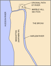
. Marble Hill, part of the borough of Manhattan, was cut off from the island by the construction of the ship canal and is now located on the mainland after the previous course of the river was filled in.
The Harlem River Ship Canal was cut through upper Manhattan to allow larger ships to navigate. It was completed in 1895. To allow passage through the remainder of the river, the existing fixed bridges were replaced by drawbridges.
Spuyten Duyvil Creek originally flowed north of Manhattan's Marble Hill
Marble Hill, Manhattan
Marble Hill is the neighborhood which makes up the northernmost part of the Borough of Manhattan in New York City, United States. Although it is politically part of Manhattan and New York County, because of the re-routing of the Harlem River, it is located on the North American mainland contiguous...
, and the completion of the canal to the south turned Marble Hill into an island, until 1914, when the original creekbed was filled in and Marble Hill became physically attached to the Bronx.
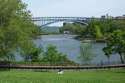
Today Spuyten Duyvil Creek, the Harlem River Ship Canal, and the Harlem River form a continuous channel. The Ship Canal is crossed by the Broadway Bridge, a vertical lift bridge carrying vehicular and pedestrian traffic on one level, and the subway on the upper level.
External links
- History of Spuyten Duyvil Creek from Washington Heights & Inwood Online
- Another translation of 'Spuyten Duyvil'
- John H. Betts The Minerals of New York City originally published in Rocks & Minerals magazine, Volume 84, No . 3 pages 204-252 (2009).