
New York State Route 10
Encyclopedia
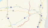
New York State Route 10 (NY 10) is a north–south state highway
in the Central New York
and North Country
regions of New York
in the United States
. It extends for 155 miles (249 km) from the Quickway (NY 17
) in Deposit, Delaware County to NY 8
at Higgins Bay, a hamlet in the Hamilton County
town of Arietta
. NY 10 begins concurrent
to NY 8, the southern terminus of which is also located at the Quickway in Deposit. While NY 8 follows a more westerly alignment between Deposit and Higgins Bay via Utica
, NY 10 veers to the east, serving Delhi
, Cobleskill
, and Canajoharie
. Along the way, the road intersects Interstate 88
(I-88) near Cobleskill and U.S. Route 20
(US 20) in Sharon Springs
.
NY 10 was assigned in 1924; however, it initially followed a completely different alignment than it does today. At the time, it began at the New Jersey
state line in Rockland County
and followed modern US 9W
north to Albany
. From here, it continued to Saranac Lake
via Schenectady
, Saratoga Springs
, Lake George
, Chestertown
, North Creek
, Long Lake
, and Tupper Lake. It was extended northeast to Plattsburgh
by 1926 but truncated to Schenectady in 1927. In the 1930 renumbering of state highways in New York, all of NY 10 south of Long Lake and north of Lake Clear Junction was moved onto a new, more westerly alignment through the state. The route was cut back to its current northern terminus in Arietta ca. 1960.
with NY 8
at an interchange with the Quickway (NY 17
) southeast of the village of Deposit near the Broome
-Delaware County
line. The two routes continue north along the eastern extents of Deposit to the banks of the west branch of the Delaware River
, where NY 8 breaks from NY 10 to cross over the river. NY 10, however, continues northeast along the riverbank, passing south of the Cannonsville Dam and the resulting Cannonsville Reservoir
behind it. Near the midpoint of the water body, NY 10 crosses over the reservoir on the Cannonsville Bridge and proceeds to follow the northern edge of the reservoir. As the reservoir begins to narrow, NY 10 intersects NY 268
, a connector route leading south to the village of Hancock
.
Past the end of the reservoir, NY 10 continues northeast in the vicinity of the Delaware River to Walton
, a village located directly on the banks of the river. Within the village limits, NY 10 overlaps NY 206
along Delaware Street before separating from the route and proceeding east out of the village. NY 10 remains alongside the Delaware as it continues northeast to Delhi
, the home of the State University of New York at Delhi
. After passing along the eastern edge of the campus, NY 10 intersects and briefly overlaps NY 28
through the village center before quietly leaving the area.
14 miles (23 km) northeast of Delhi in northeastern Delaware County, NY 10 passes through both Hobart
and Stamford
, a pair of villages located on the northernmost few miles of the Delaware's west branch. In the latter, NY 10 meets NY 23
. North of Stamford in Schoharie County
, NY 10 turns northeast, bypassing the 2900 feet (883.9 m) tall Mine Hill, home to the source of the west branch of the Delaware. At the northern edge of the hill, NY 10 curves back to the northwest to serve the Jefferson
hamlet of the same name.
 Outside of Jefferson, NY 10 continues onward through rural Schoharie County, passing through only small roadside hamlets before entering the village of Richmondville
, a community situated on NY 7
and the Cobleskill Creek. NY 10 bypasses the village to the southeast, however, and intersects both NY 7 and I-88
, the limited-access highway that parallels much of NY 7, east of the village center. NY 10 turns east, overlapping NY 7 through the State University of New York at Cobleskill
campus and into Cobleskill
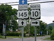
, where NY 7 and NY 10 intersect NY 145
at Grand Street. Here, NY 10, as well as NY 145 (which is concurrent with NY 7 east of this point), leave NY 7 and continue north for two blocks before NY 10 leaves NY 145 and heads west out of the village on Elm Street.
Between Cobleskill and Sharon Springs
, NY 10 proceeds northwest through rural terrain once more, with the points of interest limited to a small number of hamlets. Midway between the two locations in Seward
, NY 10 intersects NY 165
, a connector leading to Cooperstown
via NY 166
and Otsego County Route 52. In Sharon Springs, a village situated in northwest Schoharie County, NY 10 intersects US 20. Shortly after exiting the village, NY 10 passes into Montgomery County
.
, a small community based around the junction of NY 10 and County Routes 88 and 89 and situated south of the Canajoharie Creek. NY 10 crosses over the creek shortly afterward and follows the waterway downhill. Upon entering the village of Canajoharie
, NY 10 uses Reed Street, Walnut Street, and Rock Street which form a switchback
to ease the descent before entering a valley containing the conjoined Mohawk River
and Erie Canal
and the New York State Thruway
(I-90).
 Downtown, maintenance of NY 10 shifts from the New York State Department of Transportation
(NYSDOT) to the village at Mohawk Street. The highway remains locally-owned for three blocks to Incinerator Road, where the route becomes state-maintained once more. During this stretch, NY 10 intersects NY 5S
at Main Street. North of Incinerator Road, the route passes under the Thruway before crossing into the neighboring village of Palatine Bridge
at the midpoint of the Mohawk River. On the northern riverbank, NY 10 meets NY 5
and overlaps the route westward for a block before continuing northward into the largely rural town of Palatine
.
6 miles (9.7 km) from Palatine Bridge, NY 10 passes into the Fulton County
town of Ephratah
and intersects NY 67
just inside the county line. NY 67 turns north, joining NY 10 to the community of Ephratah, where it splits from NY 10 and heads east to Johnstown
. NY 10, however, continues northward in the vicinity of Caroga Creek to an intersection with NY 29
near the hamlet of Garoga. The two routes join for roughly 1.5 miles (2.4 km) before separating as the roadway crosses over the Blue Line
into Adirondack Park.
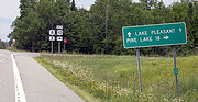
and follows the route out of the area. Together, NY 10 and NY 29A head northward through a region dotted with small lakes, as well as the larger Canada Lake, before splitting in the vicinity of Pine Lake.
Farther north, NY 10 passes directly between the Stoner Lakes, a pair of small water bodies separated by only NY 10, just south of where it crosses into Hamilton County
. For most of its run through the county, NY 10 parallels a waterbody, namely the west branch of the Sacandaga River
to where the Piseco Outlet flows into it, then the Piseco Outlet north to Big Bay near the community of Higgins Bay. NY 10 terminates soon after at an intersection with NY 8
south of Piseco Lake, west of Spy Lake, and southwest of Higgins Bay.
 In 1908, the New York State Legislature designated the primary north–south roadway along the west bank of the Hudson River
from the New Jersey
state line near New York City
to Albany
, now largely US 9W
, as Route 3, an unsigned legislative route
. When the first set of posted routes in New York were assigned in 1924, all of legislative Route 3 became part of the new NY 10, which initially began at the New Jersey state line and ended in Saranac Lake
. North of Albany, the route followed modern NY 5
, NY 50
, and NY 9N
through Schenectady
and Saratoga Springs
to reach the North Country
at Lake George
. Past this point, NY 10 continued north on what is now US 9, NY 8
, NY 28
, NY 28N
, and NY 30
to Tupper Lake via Chestertown
, Wevertown
, North Creek
, and Long Lake
. At Tupper Lake, the route headed east on current NY 3
to Wawbeek before taking a more circuitous route to Saranac Lake by way of modern NY 30, NY 186
, and NY 86
.
The first change to the routing of NY 10 came by 1926 when NY 10 was extended northeastward over modern NY 3 to Plattsburgh
, where it terminated at NY 30 (now NY 22
). The route was truncated one year later when US 9W was assigned to the portion of NY 10 between New Jersey and Albany. NY 10 was subsequently truncated to the former western terminus of its overlap with NY 5 in Schenectady. In the 1930 renumbering of state highways in New York, NY 10 was significantly reconfigured to begin in Deposit and end at the Canadian border north of Malone
. The only segment of NY 10 not altered by the realignment, which utilized a combination of previously numbered routes and unsigned roadways, was the piece between Long Lake and Lake Clear Junction.
 From Deposit to Stamford
, NY 10 supplanted NY 51, a highway assigned in the mid-1920s. Farther north, the portion from Palatine Bridge
to Indian Lake
was originally part of NY 80
, a route created in the late 1920s. Past Indian Lake, NY 10 followed what had been part of NY 10A to Long Lake, where it connected to its pre-1930 alignment. The section of modern NY 10 between Stamford and Palatine Bridge was previously unnumbered. North of Lake Clear Junction, the route followed the pre-1930 routing of NY 3 from Paul Smiths
to Malone and two previously unnumbered highways between Lake Clear Junction and Paul Smiths and from Malone to the Canadian border. NY 10 was truncated to its current northern terminus in Arietta
and largely replaced with NY 30 north of Speculator ca. 1960.
 There are two highways that have been designated NY 10A.
State highway
State highway, state road or state route can refer to one of three related concepts, two of them related to a state or provincial government in a country that is divided into states or provinces :#A...
in the Central New York
Central New York Region
The Central New York Region is a term used by the New York State Department of Economic Development to broadly describe the central region of New York State for tourism purposes. The region roughly corresponds to the upper Susquehanna and Mohawk Valleys...
and North Country
North Country, New York
The North Country is a region of the U.S. state of New York that encompasses the state's extreme northern frontier, bordering Lake Ontario on the west, the Saint Lawrence River and the Canadian provinces of Ontario and Quebec on the north and northwest, and Lake Champlain and Vermont on the east...
regions of New York
New York
New York is a state in the Northeastern region of the United States. It is the nation's third most populous state. New York is bordered by New Jersey and Pennsylvania to the south, and by Connecticut, Massachusetts and Vermont to the east...
in the United States
United States
The United States of America is a federal constitutional republic comprising fifty states and a federal district...
. It extends for 155 miles (249 km) from the Quickway (NY 17
New York State Route 17
New York State Route 17 is a state highway that extends for through the Southern Tier and Downstate regions of New York in the United States...
) in Deposit, Delaware County to NY 8
New York State Route 8
New York State Route 8 is a state highway in the central part of New York in the United States. It runs in a southwest-to-northeast direction from the Southern Tier to the northern part of Lake George. The southern terminus of the route is at an interchange with NY 17 in the town of...
at Higgins Bay, a hamlet in the Hamilton County
Hamilton County, New York
Hamilton County is a county located in the U.S. state of New York. It is named after Alexander Hamilton, the only member of the New York State delegation who signed the United States Constitution in 1787 and later the first United States Secretary of the Treasury. Its county seat is Lake Pleasant...
town of Arietta
Arietta, New York
Arietta is a town in Hamilton County, New York, United States. The population was 293 at the 2000 census. The town was named after the mother of one of the first settlers, Rensselaer Van Rennslaer...
. NY 10 begins concurrent
Concurrency (road)
A concurrency, overlap, or coincidence in a road network is an instance of one physical road bearing two or more different highway, motorway, or other route numbers...
to NY 8, the southern terminus of which is also located at the Quickway in Deposit. While NY 8 follows a more westerly alignment between Deposit and Higgins Bay via Utica
Utica, New York
Utica is a city in and the county seat of Oneida County, New York, United States. The population was 62,235 at the 2010 census, an increase of 2.6% from the 2000 census....
, NY 10 veers to the east, serving Delhi
Delhi (village), New York
Delhi is a village in Delaware County, New York, United States. The population was 2,583 at the 2000 census. Delhi is the county seat of Delaware County...
, Cobleskill
Cobleskill (village), New York
Cobleskill is a village in the western part of the town of Cobleskill in Schoharie County, New York, USA. The population was 4,533 at the 2000 census.The village is southwest of Amsterdam...
, and Canajoharie
Canajoharie (village), New York
Canajoharie is a village in the town of Canajoharie in Montgomery County, New York, USA. As of the 2000 census, the village had a population of 2,257...
. Along the way, the road intersects Interstate 88
Interstate 88 (east)
Interstate 88 is an intrastate Interstate Highway entirely within the U.S. state of New York. Its western end is at Interstate 81 in Binghamton and its eastern end is at Interstate 90 in Schenectady. It serves as an important connector route from Albany to Binghamton, Elmira , and...
(I-88) near Cobleskill and U.S. Route 20
U.S. Route 20 in New York
U.S. Route 20 is a part of the U.S. Highway System that runs from Newport, Oregon, to Boston, Massachusetts. In the U.S. state of New York, US 20 extends from the Pennsylvania state line at Ripley to the Massachusetts state line in the Berkshire Mountains. US 20 is the longest...
(US 20) in Sharon Springs
Sharon Springs, New York
Sharon Springs is a village in Schoharie County, New York, United States. The population was 547 at the 2000 census. Its name derives from the hometown of the first Colonial settlers, Sharon, Connecticut, and the important springs in the village...
.
NY 10 was assigned in 1924; however, it initially followed a completely different alignment than it does today. At the time, it began at the New Jersey
New Jersey
New Jersey is a state in the Northeastern and Middle Atlantic regions of the United States. , its population was 8,791,894. It is bordered on the north and east by the state of New York, on the southeast and south by the Atlantic Ocean, on the west by Pennsylvania and on the southwest by Delaware...
state line in Rockland County
Rockland County, New York
Rockland County is a suburban county 15 miles to the northwest of Manhattan and part of the New York City Metropolitan Area, in the U.S. state of New York. It is the southernmost county in New York west of the Hudson River, and the smallest county in New York outside of New York City. The...
and followed modern US 9W
U.S. Route 9W
U.S. Route 9W is a north–south U.S. Highway in the states of New Jersey and New York. It begins on Fletcher Avenue in Fort Lee, New Jersey as it crosses the US 1 & 9, US 46, and the Interstate 95 approaches to the George Washington Bridge, where it heads north up the west...
north to Albany
Albany, New York
Albany is the capital city of the U.S. state of New York, the seat of Albany County, and the central city of New York's Capital District. Roughly north of New York City, Albany sits on the west bank of the Hudson River, about south of its confluence with the Mohawk River...
. From here, it continued to Saranac Lake
Saranac Lake, New York
Saranac Lake is a village located in the state of New York, United States. As of the 2010 census, the population was 5,406. The village is named after Upper, Middle, and Lower Saranac Lakes, which are nearby....
via Schenectady
Schenectady, New York
Schenectady is a city in Schenectady County, New York, United States, of which it is the county seat. As of the 2010 census, the city had a population of 66,135...
, Saratoga Springs
Saratoga Springs, New York
Saratoga Springs, also known as simply Saratoga, is a city in Saratoga County, New York, United States. The population was 26,586 at the 2010 census. The name reflects the presence of mineral springs in the area. While the word "Saratoga" is known to be a corruption of a Native American name, ...
, Lake George
Lake George (village), New York
The Village of Lake George is a village within the town of Lake George in Warren County, New York, United States. The population was 985 at the 2000 census. It is part of the Glens Falls Metropolitan Statistical Area...
, Chestertown
Chestertown, New York
Chestertown is a hamlet in Warren County, New York, United States, in the Adirondack Mountains, in the Town of Chester. The population was 2,187 at the 2000 census. The community is located by the junction of Route 8 and U.S. Route 9....
, North Creek
North Creek, New York
North Creek is a hamlet in the Adirondack Park, in the town of Johnsburg, in Warren County, New York, United States. It is an area known for skiing , hiking and other outdoor recreational activities. It is located at ....
, Long Lake
Long Lake, New York
Long Lake is a town in Hamilton County, New York in the United States. The population was 852 at the 2000 census. The town is named for long Long Lake beside which it sits. The town is entirely within the Adirondack Park and is the most northerly town in the county. It is a summer tourism...
, and Tupper Lake. It was extended northeast to Plattsburgh
Plattsburgh (city), New York
Plattsburgh is a city in and county seat of Clinton County, New York, United States. The population was 19,989 at the 2010 census. The population of the unincorporated areas within the Town of Plattsburgh was 11,870 as of the 2010 census; making the population for the immediate, urban Plattsburgh,...
by 1926 but truncated to Schenectady in 1927. In the 1930 renumbering of state highways in New York, all of NY 10 south of Long Lake and north of Lake Clear Junction was moved onto a new, more westerly alignment through the state. The route was cut back to its current northern terminus in Arietta ca. 1960.
Southern Tier
NY 10 begins concurrentConcurrency (road)
A concurrency, overlap, or coincidence in a road network is an instance of one physical road bearing two or more different highway, motorway, or other route numbers...
with NY 8
New York State Route 8
New York State Route 8 is a state highway in the central part of New York in the United States. It runs in a southwest-to-northeast direction from the Southern Tier to the northern part of Lake George. The southern terminus of the route is at an interchange with NY 17 in the town of...
at an interchange with the Quickway (NY 17
New York State Route 17
New York State Route 17 is a state highway that extends for through the Southern Tier and Downstate regions of New York in the United States...
) southeast of the village of Deposit near the Broome
Broome County, New York
Broome County is a county located in the U.S. state of New York. As of the 2010 census, the population was 200,600. It was named in honor of John Broome, who was lieutenant governor in 1806 when Broome County was established. Its county seat is Binghamton, which is also its major city. The current...
-Delaware County
Delaware County, New York
Delaware County is a county located in the U.S. state of New York. As of 2010 the population was 47,980. The county seat is Delhi. It is named after the Delaware River, which was named in honor of Thomas West, 3rd Baron De La Warr, appointed governor of Virginia in 1609.-History:When counties...
line. The two routes continue north along the eastern extents of Deposit to the banks of the west branch of the Delaware River
West Branch Delaware River
The West Branch Delaware River, approximately 90 mi long in the U.S. states of New York and Pennsylvania, is one of the two branches, along with the East Branch, that join to form the Delaware River...
, where NY 8 breaks from NY 10 to cross over the river. NY 10, however, continues northeast along the riverbank, passing south of the Cannonsville Dam and the resulting Cannonsville Reservoir
Cannonsville Reservoir
The Cannonsville Reservoir is a reservoir in Delaware County, New York, that was formed by impounding over half of the West Branch of the Delaware River. It is the westernmost of New York City's reservoirs, being at the western portion of the Delaware Watershed. Placed in service in 1964, it is the...
behind it. Near the midpoint of the water body, NY 10 crosses over the reservoir on the Cannonsville Bridge and proceeds to follow the northern edge of the reservoir. As the reservoir begins to narrow, NY 10 intersects NY 268
New York State Route 268
New York State Route 268 is a state highway located in southwestern Delaware County, New York in the United States. It runs from NY 97 in Hancock north over to a bridge over Cannonsville Reservoir near the former site of the hamlet of Rock Rift in Tompkins. There, it ends at a junction...
, a connector route leading south to the village of Hancock
Hancock (village), New York
Hancock is a village in Delaware County, New York, United States. The population was 1,189 at the 2000 census.The Village of Hancock is in the west part of the Town of Hancock at the junction of NY Routes 17 and 97....
.
Past the end of the reservoir, NY 10 continues northeast in the vicinity of the Delaware River to Walton
Walton (village), New York
Walton is a village in the town of Walton, Delaware County, New York, USA. As of the 2000 census, the village population was 3,070.Walton is the home to the annual Delaware County Fair.-History:...
, a village located directly on the banks of the river. Within the village limits, NY 10 overlaps NY 206
New York State Route 206
New York State Route 206 is a state highway in the Southern Tier of New York, United States. It runs through some lightly populated regions along the state's southern border, from Central New York to the Catskills. It begins near a busy intersection with Interstate 81 at Whitney Point...
along Delaware Street before separating from the route and proceeding east out of the village. NY 10 remains alongside the Delaware as it continues northeast to Delhi
Delhi (village), New York
Delhi is a village in Delaware County, New York, United States. The population was 2,583 at the 2000 census. Delhi is the county seat of Delaware County...
, the home of the State University of New York at Delhi
State University of New York at Delhi
The State University of New York at Delhi is one of the technology colleges of the State University of New York system. It is located in the Town of Delhi, New York, United States, which is in the Catskill Mountains. The university, entirely in Delhi, is partially within the Village of Delhi....
. After passing along the eastern edge of the campus, NY 10 intersects and briefly overlaps NY 28
New York State Route 28
New York State Route 28 is a state highway extending for in the shape of a "C" between the Hudson Valley city of Kingston and southern Warren County in the U.S. state of New York. Along the way, it intersects several major routes, including Interstate 88 , U.S. Route 20 , and the...
through the village center before quietly leaving the area.
14 miles (23 km) northeast of Delhi in northeastern Delaware County, NY 10 passes through both Hobart
Hobart, New York
Hobart is a village in Delaware County, New York, United States. The population was 390 at the 2000 census.The Village of Hobart is in the Town of Stamford...
and Stamford
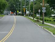
Stamford (village), New York
Stamford is a village in Delaware County, New York, United States. The population was 1,265 at the 2000 census.The Village of Stamford is located partly in the Town of Stamford and partly in the Town of Harpersfield. The village is on routes 23 and 10...
, a pair of villages located on the northernmost few miles of the Delaware's west branch. In the latter, NY 10 meets NY 23
New York State Route 23
New York State Route 23 is an east–west state highway in the eastern portion New York in the United States. It extends for from an intersection with NY 26 in the Central New York town of Cincinnatus to the Massachusetts state line in the Berkshire Mountains, where it continues east as...
. North of Stamford in Schoharie County
Schoharie County, New York
As of the census of 2000, there were 31,582 people, 11,991 households and 8,177 families residing in the county. The population density was 51 people per square mile . There were 15,915 housing units at an average density of 26 per square mile...
, NY 10 turns northeast, bypassing the 2900 feet (883.9 m) tall Mine Hill, home to the source of the west branch of the Delaware. At the northern edge of the hill, NY 10 curves back to the northwest to serve the Jefferson
Jefferson, New York
----Jefferson is a town in Schoharie County, New York, USA. The population was 1,285 at the 2000 census.The Town of Jefferson is on the southwestern border of the county and is east of the City of Oneonta.- History :...
hamlet of the same name.
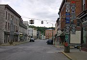
Richmondville (village), New York
Richmondville is a village in Schoharie County, New York, USA. The population was 918 at the 2010 census.The Village of Richmondville is in the center of the Town of Richmondville and is northeast of Oneonta.- History :...
, a community situated on NY 7
New York State Route 7
New York State Route 7 is a 180-mile long New York State Highway that runs from the New York/Pennsylvania border south of Binghamton, New York to the New York/Vermont border east of Hoosick. Most of the road runs along the Susquehanna Valley, closely paralleling Interstate 88 throughout...
and the Cobleskill Creek. NY 10 bypasses the village to the southeast, however, and intersects both NY 7 and I-88
Interstate 88 (east)
Interstate 88 is an intrastate Interstate Highway entirely within the U.S. state of New York. Its western end is at Interstate 81 in Binghamton and its eastern end is at Interstate 90 in Schenectady. It serves as an important connector route from Albany to Binghamton, Elmira , and...
, the limited-access highway that parallels much of NY 7, east of the village center. NY 10 turns east, overlapping NY 7 through the State University of New York at Cobleskill
State University of New York at Cobleskill
The State University of New York College of Agriculture and Technology at Cobleskillis an accredited polytechnic college that is primarily baccalaureate and residential. SUNY Cobleskill is one of few institutions in the United States where an undergraduate student may also choose to earn an...
campus and into Cobleskill
Cobleskill (village), New York
Cobleskill is a village in the western part of the town of Cobleskill in Schoharie County, New York, USA. The population was 4,533 at the 2000 census.The village is southwest of Amsterdam...
, where NY 7 and NY 10 intersect NY 145
New York State Route 145
New York State Route 145 is a state highway in eastern New York in the United States. The highway extends for from NY 23 in the Greene County town of Cairo to U.S. Route 20 in the Schoharie County town of Sharon. Along the way, NY 145 intersects NY 30 in Middleburgh and...
at Grand Street. Here, NY 10, as well as NY 145 (which is concurrent with NY 7 east of this point), leave NY 7 and continue north for two blocks before NY 10 leaves NY 145 and heads west out of the village on Elm Street.
Between Cobleskill and Sharon Springs
Sharon Springs, New York
Sharon Springs is a village in Schoharie County, New York, United States. The population was 547 at the 2000 census. Its name derives from the hometown of the first Colonial settlers, Sharon, Connecticut, and the important springs in the village...
, NY 10 proceeds northwest through rural terrain once more, with the points of interest limited to a small number of hamlets. Midway between the two locations in Seward
Seward, New York
Seward is a town in Schoharie County, New York, United States. The population was 1,637 at the 2000 census. The town is named after senator, governor, and secretary of state William H...
, NY 10 intersects NY 165
New York State Route 165
New York State Route 165 is an east–west state highway in eastern New York, United States. It serves as a connector between NY 166 in the Otsego County town of Roseboom and NY 10 in the Schoharie County town of Seward...
, a connector leading to Cooperstown
Cooperstown, New York
Cooperstown is a village in Otsego County, New York, USA. It is located in the Town of Otsego. The population was estimated to be 1,852 at the 2010 census.The Village of Cooperstown is the county seat of Otsego County, New York...
via NY 166
New York State Route 166
New York State Route 166 is a north–south state highway in Otsego County, New York, United States. It extends for from NY 28 in the village of Milford to U.S. Route 20 north of the village of Cherry Valley. Much of NY 166's southern portion is near Cooperstown, and various...
and Otsego County Route 52. In Sharon Springs, a village situated in northwest Schoharie County, NY 10 intersects US 20. Shortly after exiting the village, NY 10 passes into Montgomery County
Montgomery County, New York
As of the census of 2000, there were 49,708 people, 20,038 households, and 13,104 families residing in the county. The population density was 123 people per square mile . There were 22,522 housing units at an average density of 56 per square mile...
.
Montgomery, Fulton and Hamilton Counties
Just across the county line, NY 10 passes through the village of AmesAmes, New York
Ames is a village in Montgomery County, New York, United States. The population was 173 at the 2000 census.The Village of Ames is in the south-central part of the Town of Canajoharie and is south of the Village of Canajoharie....
, a small community based around the junction of NY 10 and County Routes 88 and 89 and situated south of the Canajoharie Creek. NY 10 crosses over the creek shortly afterward and follows the waterway downhill. Upon entering the village of Canajoharie
Canajoharie (village), New York
Canajoharie is a village in the town of Canajoharie in Montgomery County, New York, USA. As of the 2000 census, the village had a population of 2,257...
, NY 10 uses Reed Street, Walnut Street, and Rock Street which form a switchback
Hairpin turn
A hairpin turn , named for its resemblance to a hairpin/bobby pin, is a bend in a road with a very acute inner angle, making it necessary for an oncoming vehicle to turn almost 180° to continue on the road. Such turns in ramps and trails may be called switchbacks in American English, by analogy...
to ease the descent before entering a valley containing the conjoined Mohawk River
Mohawk River
The Mohawk River is a river in the U.S. state of New York. It is the largest tributary of the Hudson River. The Mohawk flows into the Hudson in the Capital District, a few miles north of the city of Albany. The river is named for the Mohawk Nation of the Iroquois Confederacy...
and Erie Canal
Erie Canal
The Erie Canal is a waterway in New York that runs about from Albany, New York, on the Hudson River to Buffalo, New York, at Lake Erie, completing a navigable water route from the Atlantic Ocean to the Great Lakes. The canal contains 36 locks and encompasses a total elevation differential of...
and the New York State Thruway
New York State Thruway
The New York State Thruway is a system of limited-access highways located within the state of New York in the United States. The system, known officially as the Governor Thomas E. Dewey Thruway for former New York Governor Thomas E. Dewey, is operated by the New York State Thruway Authority and...
(I-90).
New York State Department of Transportation
The New York State Department of Transportation is responsible for the development and operation of highways, railroads, mass transit systems, ports, waterways and aviation facilities in the U.S...
(NYSDOT) to the village at Mohawk Street. The highway remains locally-owned for three blocks to Incinerator Road, where the route becomes state-maintained once more. During this stretch, NY 10 intersects NY 5S
New York State Route 5S
New York State Route 5S is an east–west state highway located in the Mohawk Valley of New York in the United States. It extends for from an interchange with NY 5, NY 5A, NY 8, and NY 12 in Utica to a smaller interchange with NY 890 in Rotterdam...
at Main Street. North of Incinerator Road, the route passes under the Thruway before crossing into the neighboring village of Palatine Bridge
Palatine Bridge, New York
Palatine Bridge is a village in Montgomery County, New York, United States. The population was 706 at the 2000 census. The basis of the name is the community's location in a region settled by Palatinate Germans....
at the midpoint of the Mohawk River. On the northern riverbank, NY 10 meets NY 5
New York State Route 5
New York State Route 5 is a state highway that extends for across the state of New York in the United States. It begins at the Pennsylvania state line in the Chautauqua County town of Ripley and passes through Buffalo, Syracuse, Utica, Schenectady, and several other smaller cities and...
and overlaps the route westward for a block before continuing northward into the largely rural town of Palatine
Palatine, New York
Palatine is a town in Montgomery County, New York, United States. The population was 3,240 at the 2010 census. The named is derived from the Palatinate in the Rhineland, the homeland of the early settlers of this region....
.
6 miles (9.7 km) from Palatine Bridge, NY 10 passes into the Fulton County
Fulton County, New York
Fulton County is a county located in the U.S. state of New York. As of the 2010 census, the population was 55,531. Its name is in honor of Robert Fulton, who is widely credited with developing the first commercially successful steamboat...
town of Ephratah
Ephratah, New York
Ephratah is a town in Fulton County, New York, United States. The population was 1,693 at the 2000 census. The name is from the Bible and means "fruitful."...
and intersects NY 67
New York State Route 67
New York State Route 67 is an east–west state highway in eastern New York in the United States. The western terminus of the route is at an intersection with NY 5 in the town of St. Johnsville...
just inside the county line. NY 67 turns north, joining NY 10 to the community of Ephratah, where it splits from NY 10 and heads east to Johnstown
Johnstown (city), New York
Johnstown is a city and the county seat of Fulton County in the U.S. state of New York. As of the 2000 Census, the city had population of 8,511. Recent estimates put the figure closer to 8,100. The city was named by its founder, Sir William Johnson after his son John Johnson...
. NY 10, however, continues northward in the vicinity of Caroga Creek to an intersection with NY 29
New York State Route 29
New York State Route 29 is a state highway extending for across the eastern portion of the U.S. state of New York. The western terminus of the route is at NY 28 and NY 169 in Middleville, Herkimer County. The eastern terminus of the route is at NY 22 just south of Salem,...
near the hamlet of Garoga. The two routes join for roughly 1.5 miles (2.4 km) before separating as the roadway crosses over the Blue Line
Blue Line (New York State)
The Blue Line is the term used in New York state for the boundaries of the Adirondack and Catskill parks, within which can be found the state's Forest Preserve...
into Adirondack Park.
Adirondack Park
North of Rockwood, the community centered around the northern split of the overlap between NY 10 and NY 29, NY 10 intersects NY 10A, an alternate route around Rockwood Lake to the east. Farther north, NY 10 enters Caroga Lake, a community situated on the eastern edges of West and East Caroga Lakes. In the center of the hamlet, NY 10 meets NY 29ANew York State Route 29A
New York State Route 29A is a state highway in the western portion of the Capital District of New York in the United States. The western terminus of the route is at an intersection with NY 29 in the Herkimer County hamlet of Salisbury Center. Its eastern end is at another junction with...
and follows the route out of the area. Together, NY 10 and NY 29A head northward through a region dotted with small lakes, as well as the larger Canada Lake, before splitting in the vicinity of Pine Lake.
Farther north, NY 10 passes directly between the Stoner Lakes, a pair of small water bodies separated by only NY 10, just south of where it crosses into Hamilton County
Hamilton County, New York
Hamilton County is a county located in the U.S. state of New York. It is named after Alexander Hamilton, the only member of the New York State delegation who signed the United States Constitution in 1787 and later the first United States Secretary of the Treasury. Its county seat is Lake Pleasant...
. For most of its run through the county, NY 10 parallels a waterbody, namely the west branch of the Sacandaga River
Sacandaga River
The Sacandaga River is a river in the northern part of New York in the United States. Its name comes from the Native American Sa-chen-da'-ga, meaning "overflowed lands"....
to where the Piseco Outlet flows into it, then the Piseco Outlet north to Big Bay near the community of Higgins Bay. NY 10 terminates soon after at an intersection with NY 8
New York State Route 8
New York State Route 8 is a state highway in the central part of New York in the United States. It runs in a southwest-to-northeast direction from the Southern Tier to the northern part of Lake George. The southern terminus of the route is at an interchange with NY 17 in the town of...
south of Piseco Lake, west of Spy Lake, and southwest of Higgins Bay.
History
Hudson River
The Hudson is a river that flows from north to south through eastern New York. The highest official source is at Lake Tear of the Clouds, on the slopes of Mount Marcy in the Adirondack Mountains. The river itself officially begins in Henderson Lake in Newcomb, New York...
from the New Jersey
New Jersey
New Jersey is a state in the Northeastern and Middle Atlantic regions of the United States. , its population was 8,791,894. It is bordered on the north and east by the state of New York, on the southeast and south by the Atlantic Ocean, on the west by Pennsylvania and on the southwest by Delaware...
state line near New York City
New York City
New York is the most populous city in the United States and the center of the New York Metropolitan Area, one of the most populous metropolitan areas in the world. New York exerts a significant impact upon global commerce, finance, media, art, fashion, research, technology, education, and...
to Albany
Albany, New York
Albany is the capital city of the U.S. state of New York, the seat of Albany County, and the central city of New York's Capital District. Roughly north of New York City, Albany sits on the west bank of the Hudson River, about south of its confluence with the Mohawk River...
, now largely US 9W
U.S. Route 9W
U.S. Route 9W is a north–south U.S. Highway in the states of New Jersey and New York. It begins on Fletcher Avenue in Fort Lee, New Jersey as it crosses the US 1 & 9, US 46, and the Interstate 95 approaches to the George Washington Bridge, where it heads north up the west...
, as Route 3, an unsigned legislative route
Legislative route
In United States, a legislative route or legislative highway is a highway defined by laws passed in a state legislature. The numbering of such highways may or may not correspond to the numbers familiar to the public as part of the state, U.S. highway, and Interstate highway systems...
. When the first set of posted routes in New York were assigned in 1924, all of legislative Route 3 became part of the new NY 10, which initially began at the New Jersey state line and ended in Saranac Lake
Saranac Lake, New York
Saranac Lake is a village located in the state of New York, United States. As of the 2010 census, the population was 5,406. The village is named after Upper, Middle, and Lower Saranac Lakes, which are nearby....
. North of Albany, the route followed modern NY 5
New York State Route 5
New York State Route 5 is a state highway that extends for across the state of New York in the United States. It begins at the Pennsylvania state line in the Chautauqua County town of Ripley and passes through Buffalo, Syracuse, Utica, Schenectady, and several other smaller cities and...
, NY 50
New York State Route 50
New York State Route 50 is a state highway in the Capital District of New York in the United States. The southern terminus of the route is at an intersection with NY 5 in Scotia...
, and NY 9N
New York State Route 9N
New York State Route 9N is a north–south state highway in northeastern New York, United States. It extends from an intersection with U.S. Route 9 , NY 29, and NY 50 in the city of Saratoga Springs to a junction with US 9 and NY 22 in the Clinton County village of...
through Schenectady
Schenectady, New York
Schenectady is a city in Schenectady County, New York, United States, of which it is the county seat. As of the 2010 census, the city had a population of 66,135...
and Saratoga Springs
Saratoga Springs, New York
Saratoga Springs, also known as simply Saratoga, is a city in Saratoga County, New York, United States. The population was 26,586 at the 2010 census. The name reflects the presence of mineral springs in the area. While the word "Saratoga" is known to be a corruption of a Native American name, ...
to reach the North Country
North Country, New York
The North Country is a region of the U.S. state of New York that encompasses the state's extreme northern frontier, bordering Lake Ontario on the west, the Saint Lawrence River and the Canadian provinces of Ontario and Quebec on the north and northwest, and Lake Champlain and Vermont on the east...
at Lake George
Lake George (village), New York
The Village of Lake George is a village within the town of Lake George in Warren County, New York, United States. The population was 985 at the 2000 census. It is part of the Glens Falls Metropolitan Statistical Area...
. Past this point, NY 10 continued north on what is now US 9, NY 8
New York State Route 8
New York State Route 8 is a state highway in the central part of New York in the United States. It runs in a southwest-to-northeast direction from the Southern Tier to the northern part of Lake George. The southern terminus of the route is at an interchange with NY 17 in the town of...
, NY 28
New York State Route 28
New York State Route 28 is a state highway extending for in the shape of a "C" between the Hudson Valley city of Kingston and southern Warren County in the U.S. state of New York. Along the way, it intersects several major routes, including Interstate 88 , U.S. Route 20 , and the...
, NY 28N
New York State Route 28N
New York State Route 28N is a state highway in the Adirondacks in New York that extends from Blue Mountain Lake to North Creek. The route, in length, is a northerly alternate route to NY 28 between both locations. The highway passes through several communities before terminating at...
, and NY 30
New York State Route 30
New York State Route 30 is a state highway in the central part of New York in the United States. It extends for from an interchange with NY 17 in the Southern Tier to the Canadian border in the state's North Country, where it continues into Quebec as Route 138. On a regional level,...
to Tupper Lake via Chestertown
Chestertown, New York
Chestertown is a hamlet in Warren County, New York, United States, in the Adirondack Mountains, in the Town of Chester. The population was 2,187 at the 2000 census. The community is located by the junction of Route 8 and U.S. Route 9....
, Wevertown
Wevertown, New York
Wevertown, New York, is a hamlet in the Adirondack Mountains/Adirondack Park. It is in the town of Johnsburg in the northwest corner of Warren County, New York, U.S.A., and is in the Glens Falls metropolitan area.- Geography:...
, North Creek
North Creek, New York
North Creek is a hamlet in the Adirondack Park, in the town of Johnsburg, in Warren County, New York, United States. It is an area known for skiing , hiking and other outdoor recreational activities. It is located at ....
, and Long Lake
Long Lake, New York
Long Lake is a town in Hamilton County, New York in the United States. The population was 852 at the 2000 census. The town is named for long Long Lake beside which it sits. The town is entirely within the Adirondack Park and is the most northerly town in the county. It is a summer tourism...
. At Tupper Lake, the route headed east on current NY 3
New York State Route 3
New York State Route 3 is a major east–west state highway in New York, United States, that connects central New York to the North Country region near the Canadian border via Adirondack Park. The route extends for between its western terminus at an intersection with NY 104A in the Cayuga...
to Wawbeek before taking a more circuitous route to Saranac Lake by way of modern NY 30, NY 186
New York State Route 186
New York State Route 186 is a short east–west state highway in northern New York, United States. The highway is located entirely within the town of Harrietstown in the southwest part of Franklin County. The western terminus is at NY 30 and the eastern terminus is at NY 86. ...
, and NY 86
New York State Route 86
New York State Route 86 is a long state highway located within Adirondack Park in northern New York, United States, linking Franklin County to Essex County. The western terminus of the route is at NY 30 in the hamlet of Paul Smiths. The eastern terminus is at NY 9N in Jay...
.
The first change to the routing of NY 10 came by 1926 when NY 10 was extended northeastward over modern NY 3 to Plattsburgh
Plattsburgh (city), New York
Plattsburgh is a city in and county seat of Clinton County, New York, United States. The population was 19,989 at the 2010 census. The population of the unincorporated areas within the Town of Plattsburgh was 11,870 as of the 2010 census; making the population for the immediate, urban Plattsburgh,...
, where it terminated at NY 30 (now NY 22
New York State Route 22
New York State Route 22 is a north–south state highway in eastern New York in the United States. It runs parallel to the state's eastern edge from the outskirts of New York City to a short distance south of the Canadian border. At , it is the state's longest north–south route and...
). The route was truncated one year later when US 9W was assigned to the portion of NY 10 between New Jersey and Albany. NY 10 was subsequently truncated to the former western terminus of its overlap with NY 5 in Schenectady. In the 1930 renumbering of state highways in New York, NY 10 was significantly reconfigured to begin in Deposit and end at the Canadian border north of Malone
Malone (village), New York
-Notable natives:Notable natives include:*William Almon Wheeler served as Vice President of the United States under Rutherford Hayes. Is buried at Morningside Cemetery in Malone....
. The only segment of NY 10 not altered by the realignment, which utilized a combination of previously numbered routes and unsigned roadways, was the piece between Long Lake and Lake Clear Junction.
Stamford (village), New York
Stamford is a village in Delaware County, New York, United States. The population was 1,265 at the 2000 census.The Village of Stamford is located partly in the Town of Stamford and partly in the Town of Harpersfield. The village is on routes 23 and 10...
, NY 10 supplanted NY 51, a highway assigned in the mid-1920s. Farther north, the portion from Palatine Bridge
Palatine Bridge, New York
Palatine Bridge is a village in Montgomery County, New York, United States. The population was 706 at the 2000 census. The basis of the name is the community's location in a region settled by Palatinate Germans....
to Indian Lake
Indian Lake, New York
Indian Lake is a town in Hamilton County, New York, United States. The population was 1,471 at the 2000 census. The name is from a large lake partly inside the town.The Town of Indian Lake is on the east border of the county and is northeast of Utica....
was originally part of NY 80
New York State Route 80
New York State Route 80 is a west–east New York State Route located within Onondaga, Madison, Chenango, Otsego, Herkimer, and Montgomery Counties in New York. Its western terminus is located at a junction with NY 175 in the city of Syracuse in Onondaga County, from which it...
, a route created in the late 1920s. Past Indian Lake, NY 10 followed what had been part of NY 10A to Long Lake, where it connected to its pre-1930 alignment. The section of modern NY 10 between Stamford and Palatine Bridge was previously unnumbered. North of Lake Clear Junction, the route followed the pre-1930 routing of NY 3 from Paul Smiths
Paul Smiths, New York
Paul Smiths is a hamlet in the Town of Brighton in Franklin County, New York, on Lower Saint Regis Lake, in the Adirondacks, 10 miles north of Saranac Lake, located at 44°26' North 74°15' West....
to Malone and two previously unnumbered highways between Lake Clear Junction and Paul Smiths and from Malone to the Canadian border. NY 10 was truncated to its current northern terminus in Arietta
Arietta, New York
Arietta is a town in Hamilton County, New York, United States. The population was 293 at the 2000 census. The town was named after the mother of one of the first settlers, Rensselaer Van Rennslaer...
and largely replaced with NY 30 north of Speculator ca. 1960.
NY 10A
- The original NY 10A was an alternate route of NY 10 between Long LakeLong Lake, New YorkLong Lake is a town in Hamilton County, New York in the United States. The population was 852 at the 2000 census. The town is named for long Long Lake beside which it sits. The town is entirely within the Adirondack Park and is the most northerly town in the county. It is a summer tourism...
and North CreekNorth Creek, New YorkNorth Creek is a hamlet in the Adirondack Park, in the town of Johnsburg, in Warren County, New York, United States. It is an area known for skiing , hiking and other outdoor recreational activities. It is located at ....
. It was assigned in the late 1920s and removed as part of the 1930 renumbering of state highways in New York. - The current NY 10A is a 2.41 miles (3.88 km) two-lane spur providing an alternate connection from NY 29New York State Route 29New York State Route 29 is a state highway extending for across the eastern portion of the U.S. state of New York. The western terminus of the route is at NY 28 and NY 169 in Middleville, Herkimer County. The eastern terminus of the route is at NY 22 just south of Salem,...
in Fulton CountyFulton County, New YorkFulton County is a county located in the U.S. state of New York. As of the 2010 census, the population was 55,531. Its name is in honor of Robert Fulton, who is widely credited with developing the first commercially successful steamboat...
. The route begins at NY 29 in JohnstownJohnstown (town), New YorkJohnstown is a town located in Fulton County, New York, United States. As of the 2000 U.S. Census, the town had a population of 7,166. The name of the town is from landowner William Johnson....
and heads northwest to end at NY 10 in CarogaCaroga, New YorkCaroga is a town in Fulton County, New York, USA. The population was 1,407 at the 2000 census. The town was named after a local creek.The Town of Caroga is in the northern part of the county and is north of Gloversville and Johnstown....
just inside the limits of Adirondack Park. NY 10A serves as a link for motorists wishing to access the western parts of Caroga via NY 10 from NY 29, bypassing the Rockwood hamlet, a reduced speed zone, and about a mile of highway. It was assigned ca. 1931.