
New York State Route 376
Encyclopedia
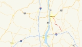
New York State Route 376 (NY 376) is a state highway
located entirely within Dutchess County
in the Hudson Valley
region of New York
, United States
. The route begins at an intersection with NY 52
in East Fishkill
and passes north through Hopewell Junction
and Red Oaks Mill
on its way to the city of Poughkeepsie
. It ends at a junction with U.S. Route 44 (US 44) and NY 55
east of the city limits in Arlington
, a hamlet in the town of Poughkeepsie
. NY 376 was originally designated as part of NY 39 in the mid-1920s. In the 1930 renumbering of state highways in New York, the East Fishkill – Poughkeepsie portion of NY 39 was renumbered to New York State Route 202. NY 202 was renumbered to NY 376 in 1934 to avoid numerical duplication with the new US 202.
 NY 376 begins at an intersection with NY 52
in the hamlet of East Fishkill
. It proceeds north about 1.5 miles (2.4 km), crossing over Fishkill Creek
and continuing into the hamlet of Hopewell Junction
, where it overlaps with NY 82
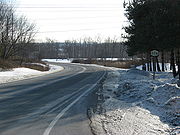
for 450 feet (137.2 m). NY 376 leaves NY 82 and continues northwest, crossing railroad tracks and following a sharp 90º S-curve with a 5 miles per hour (8 km/h) advisory speed. Soon after, the route traverses another curve, but at 20 miles per hour (32.2 km/h). After this, the speed limit returns to 45 miles per hour (72.4 km/h). NY 376 passes by the Dogwood Knolls Country Club before meeting County Route 29 (CR 29) in the hamlet of Fishkill Plains, at which point NY 376 proceeds west.
Immediately after crossing from the town of East Fishkill
into the town of Wappinger
, NY 376 turns north at an intersection with CR 93. It continues north for about 1.2 miles (1.9 km) through the hamlet of Diddell, where it turns west again towards the hamlet of New Hackensack. Here, the route meets CR 94 and CR 104. NY 376 turns north at this intersection, running along the eastern perimeter of and providing access to the passenger terminal of Dutchess County Airport
. North of the airport, NY 376 runs closely parallel to Wappinger Creek
, briefly entering the town limits of La Grange before crossing the Wappinger Creek into the town of Poughkeepsie
.
 In the Poughkeepsie hamlet of Red Oaks Mill
, NY 376 meets the eastern end of NY 113
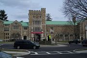
(Spackenkill Road) and the northern end of CR 77 (Vassar Road) at the center of the community. NY 376 approaches the intersection at a 45-degree angle, resulting in a series of sharp traffic movements between the three roads—the sharpest being the 135-degree turn between NY 376 northbound and Vassar Road southbound. Past the junction, NY 376 continues north on New Hackensack Road, the northward continuation of Vassar Road. After heading north and northwest for 2.3 miles (3.7 km), NY 376 turns right onto Raymond Avenue at Vassar College
. Its continuation on New Hackensack Road is known as Hooker Avenue and is designated NY 983T, an unsigned reference route, to the Poughkeepsie town/city line about 100 feet (30.5 m) from its junction with Cedar Avenue (known as CR 74 south of the city limits).
NY 376 follows Raymond Avenue for about a mile (1.6 km) to the hamlet of Arlington
. Here, it meets US 44 and NY 55
, both of which follow a one-way couplet along Haight Street (eastbound) and Maple Street (westbound) through the city of Poughkeepsie
. In between the two streets, NY 376 intersects Main Street (CR 114). The route ends upon intersecting westbound US 44 and NY 55, at which point the routing of NY 376 becomes an unnumbered town road named Van Wagner Road.
to Poughkeepsie
by way of West Patterson and East Fishkill, in the mid-1920s. In the 1930 renumbering of state highways in New York, NY 39 was reassigned to another highway
in western New York
while its former routing in the Hudson Valley
was broken up into several routes. One of these was NY 202, a new route that began in East Fishkill and ended in Poughkeepsie. The rest of NY 39 became part of NY 52
from East Fishkill
to the western fringe of Patterson, and NY 311
for the rest of the routing. In 1934, US 202 was designated by AASHO. In order to avoid a numbering conflict, NY 202 was renumbered to NY 376.
(NYSDOT) converted NY 376's intersections with the main gate of Vassar College
and College Avenue into roundabout
s. Both of the roundabouts replaced traffic lights. A traffic signal used to control traffic for a pedestrian crosswalk was also removed as part of their construction. Another roundabout was constructed in 2008 at Fulton and Collegeview Avenues. NYSDOT has called the installation of roundabouts a success, stating that it has significantly calmed traffic, decreased congestion and increased traffic flow.
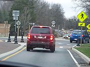 The construction of the roundabouts was controversial from the outset. The first two roundabouts were installed by NYSDOT even though both the town
and city of Poughkeepsie declared that they were opposed to the roundabouts. Additionally, the roundabouts have drawn much controversy from local residents because they remove a lane of traffic in each direction, reducing Raymond Avenue (NY 376) from a four-lane road to a divided two-lane boulevard and, thus, significantly altering pre-existing traffic patterns. A moderate amount of traffic has diverted onto alternate local routes as a result. In response, NYSDOT installed traffic calming
measures on these parallel roads prior to the construction of the Fulton Avenue roundabout.
State highway
State highway, state road or state route can refer to one of three related concepts, two of them related to a state or provincial government in a country that is divided into states or provinces :#A...
located entirely within Dutchess County
Dutchess County, New York
Dutchess County is a county located in the U.S. state of New York, in the state's Mid-Hudson Region of the Hudson Valley. The 2010 census lists the population as 297,488...
in the Hudson Valley
Hudson Valley
The Hudson Valley comprises the valley of the Hudson River and its adjacent communities in New York State, United States, from northern Westchester County northward to the cities of Albany and Troy.-History:...
region of New York
New York
New York is a state in the Northeastern region of the United States. It is the nation's third most populous state. New York is bordered by New Jersey and Pennsylvania to the south, and by Connecticut, Massachusetts and Vermont to the east...
, United States
United States
The United States of America is a federal constitutional republic comprising fifty states and a federal district...
. The route begins at an intersection with NY 52
New York State Route 52
New York State Route 52 is a long state highway in the southeastern part of New York in the United States. It generally runs from west to east, beginning at the Pennsylvania state line in the Delaware River near Narrowsburg, crossing the Hudson River on the Newburgh-Beacon Bridge, and ending...
in East Fishkill
East Fishkill, New York
East Fishkill is a town on the southern border of Dutchess County, New York, United States. The population was 25,589 at the 2000 census. The town name is derived from its formation from Fishkill, NY....
and passes north through Hopewell Junction
Hopewell Junction, New York
Hopewell Junction is a hamlet in Dutchess County, New York, United States. The population was 2,610 at the 2000 census...
and Red Oaks Mill
Red Oaks Mill, New York
Red Oaks Mill is a hamlet in Dutchess County, New York. It lies within the limits of the Town of Poughkeepsie and Town of LaGrange. The population was 4,930 at the 2000 census....
on its way to the city of Poughkeepsie
Poughkeepsie (city), New York
Poughkeepsie is a city in the state of New York, United States, which serves as the county seat of Dutchess County. Poughkeepsie is located in the Hudson River Valley midway between New York City and Albany...
. It ends at a junction with U.S. Route 44 (US 44) and NY 55
New York State Route 55
New York State Route 55 is a state highway in southern New York, running from the Pennsylvania state line at the Delaware River in Barryville to the Connecticut state line at Wingdale...
east of the city limits in Arlington
Arlington, New York
Arlington is a community in Dutchess County, New York, United States. As of the 2000 census, the CDP population was 12,481.Arlington is a suburb of the City of Poughkeepsie and is in the Town of Poughkeepsie...
, a hamlet in the town of Poughkeepsie
Poughkeepsie (town), New York
Poughkeepsie is a town in Dutchess County, New York, United States. The population was 42,777 at the 2000 census. The name is derived from the native term, "Uppu-qui-ipis-in," which means "reed-covered hut by the water."...
. NY 376 was originally designated as part of NY 39 in the mid-1920s. In the 1930 renumbering of state highways in New York, the East Fishkill – Poughkeepsie portion of NY 39 was renumbered to New York State Route 202. NY 202 was renumbered to NY 376 in 1934 to avoid numerical duplication with the new US 202.
Route description
New York State Route 52
New York State Route 52 is a long state highway in the southeastern part of New York in the United States. It generally runs from west to east, beginning at the Pennsylvania state line in the Delaware River near Narrowsburg, crossing the Hudson River on the Newburgh-Beacon Bridge, and ending...
in the hamlet of East Fishkill
East Fishkill, New York
East Fishkill is a town on the southern border of Dutchess County, New York, United States. The population was 25,589 at the 2000 census. The town name is derived from its formation from Fishkill, NY....
. It proceeds north about 1.5 miles (2.4 km), crossing over Fishkill Creek
Fishkill Creek
Fishkill Creek is a tributary of the Hudson River in Dutchess County, New York, United States. At it is the second longest stream in the county, after Wappinger Creek. It rises in the town of Union Vale and flows generally southwest to a small estuary on the Hudson just south of Beacon. Part of...
and continuing into the hamlet of Hopewell Junction
Hopewell Junction, New York
Hopewell Junction is a hamlet in Dutchess County, New York, United States. The population was 2,610 at the 2000 census...
, where it overlaps with NY 82
New York State Route 82
New York State Route 82 is a state highway in the eastern Hudson Valley of New York, United States. It begins at an intersection with NY 52 northeast of the village of Fishkill, bends eastward towards Millbrook, and then returns westward to end at a junction with U.S. Route 9,...
for 450 feet (137.2 m). NY 376 leaves NY 82 and continues northwest, crossing railroad tracks and following a sharp 90º S-curve with a 5 miles per hour (8 km/h) advisory speed. Soon after, the route traverses another curve, but at 20 miles per hour (32.2 km/h). After this, the speed limit returns to 45 miles per hour (72.4 km/h). NY 376 passes by the Dogwood Knolls Country Club before meeting County Route 29 (CR 29) in the hamlet of Fishkill Plains, at which point NY 376 proceeds west.
Immediately after crossing from the town of East Fishkill
East Fishkill, New York
East Fishkill is a town on the southern border of Dutchess County, New York, United States. The population was 25,589 at the 2000 census. The town name is derived from its formation from Fishkill, NY....
into the town of Wappinger
Wappinger, New York
Wappinger is a town of in Dutchess County, New York in the United States. The population was 26,274 at the 2000 census. The name is derived from the Wappani Indians that inhabited the area...
, NY 376 turns north at an intersection with CR 93. It continues north for about 1.2 miles (1.9 km) through the hamlet of Diddell, where it turns west again towards the hamlet of New Hackensack. Here, the route meets CR 94 and CR 104. NY 376 turns north at this intersection, running along the eastern perimeter of and providing access to the passenger terminal of Dutchess County Airport
Dutchess County Airport
Dutchess County Airport is a county-owned public-use airport located on State Route 376 in the Town of Wappinger, Dutchess County, New York, United States, four miles south of the central business district of Poughkeepsie. It is sometimes called Poughkeepsie Airport, which gives it the code POU...
. North of the airport, NY 376 runs closely parallel to Wappinger Creek
Wappinger Creek
Wappinger Creek is a creek which runs from Thompson Pond to the Hudson River at New Hamburg in Dutchess County, New York, United States. It is the longest creek in Dutchess County, with the largest watershed in the county.- Overview :...
, briefly entering the town limits of La Grange before crossing the Wappinger Creek into the town of Poughkeepsie
Poughkeepsie (town), New York
Poughkeepsie is a town in Dutchess County, New York, United States. The population was 42,777 at the 2000 census. The name is derived from the native term, "Uppu-qui-ipis-in," which means "reed-covered hut by the water."...
.
Red Oaks Mill, New York
Red Oaks Mill is a hamlet in Dutchess County, New York. It lies within the limits of the Town of Poughkeepsie and Town of LaGrange. The population was 4,930 at the 2000 census....
, NY 376 meets the eastern end of NY 113
New York State Route 113
New York State Route 113 is an east–west state highway located southeast of the city of Poughkeepsie in Dutchess County, New York, United States. The western terminus of the route is at U.S. Route 9 in the town of Poughkeepsie. Its eastern terminus is at NY 376 in the Poughkeepsie...
(Spackenkill Road) and the northern end of CR 77 (Vassar Road) at the center of the community. NY 376 approaches the intersection at a 45-degree angle, resulting in a series of sharp traffic movements between the three roads—the sharpest being the 135-degree turn between NY 376 northbound and Vassar Road southbound. Past the junction, NY 376 continues north on New Hackensack Road, the northward continuation of Vassar Road. After heading north and northwest for 2.3 miles (3.7 km), NY 376 turns right onto Raymond Avenue at Vassar College
Vassar College
Vassar College is a private, coeducational liberal arts college in the town of Poughkeepsie, New York, in the United States. The Vassar campus comprises over and more than 100 buildings, including four National Historic Landmarks, ranging in style from Collegiate Gothic to International,...
. Its continuation on New Hackensack Road is known as Hooker Avenue and is designated NY 983T, an unsigned reference route, to the Poughkeepsie town/city line about 100 feet (30.5 m) from its junction with Cedar Avenue (known as CR 74 south of the city limits).
NY 376 follows Raymond Avenue for about a mile (1.6 km) to the hamlet of Arlington
Arlington, New York
Arlington is a community in Dutchess County, New York, United States. As of the 2000 census, the CDP population was 12,481.Arlington is a suburb of the City of Poughkeepsie and is in the Town of Poughkeepsie...
. Here, it meets US 44 and NY 55
New York State Route 55
New York State Route 55 is a state highway in southern New York, running from the Pennsylvania state line at the Delaware River in Barryville to the Connecticut state line at Wingdale...
, both of which follow a one-way couplet along Haight Street (eastbound) and Maple Street (westbound) through the city of Poughkeepsie
Poughkeepsie (city), New York
Poughkeepsie is a city in the state of New York, United States, which serves as the county seat of Dutchess County. Poughkeepsie is located in the Hudson River Valley midway between New York City and Albany...
. In between the two streets, NY 376 intersects Main Street (CR 114). The route ends upon intersecting westbound US 44 and NY 55, at which point the routing of NY 376 becomes an unnumbered town road named Van Wagner Road.
Route designation
NY 376 was originally designated as part of NY 39, a route extending from PattersonPatterson, New York
Patterson is a town in Putnam County, New York, United States. The town is in the northeast part of the county. Interstate 84 passes through the southwest part of the town. The population was 11,306 at the 2000 census. The town is named after early farmer Matthew Paterson...
to Poughkeepsie
Poughkeepsie (city), New York
Poughkeepsie is a city in the state of New York, United States, which serves as the county seat of Dutchess County. Poughkeepsie is located in the Hudson River Valley midway between New York City and Albany...
by way of West Patterson and East Fishkill, in the mid-1920s. In the 1930 renumbering of state highways in New York, NY 39 was reassigned to another highway
New York State Route 39
New York State Route 39 is an east–west state highway in the western portion of New York in the United States. It begins and ends at intersections with U.S. Route 20 apart...
in western New York
Western New York
Western New York is the westernmost region of the state of New York. It includes the cities of Buffalo, Rochester, Niagara Falls, the surrounding suburbs, as well as the outlying rural areas of the Great Lakes lowlands, the Genesee Valley, and the Southern Tier. Some historians, scholars and others...
while its former routing in the Hudson Valley
Hudson Valley
The Hudson Valley comprises the valley of the Hudson River and its adjacent communities in New York State, United States, from northern Westchester County northward to the cities of Albany and Troy.-History:...
was broken up into several routes. One of these was NY 202, a new route that began in East Fishkill and ended in Poughkeepsie. The rest of NY 39 became part of NY 52
New York State Route 52
New York State Route 52 is a long state highway in the southeastern part of New York in the United States. It generally runs from west to east, beginning at the Pennsylvania state line in the Delaware River near Narrowsburg, crossing the Hudson River on the Newburgh-Beacon Bridge, and ending...
from East Fishkill
East Fishkill, New York
East Fishkill is a town on the southern border of Dutchess County, New York, United States. The population was 25,589 at the 2000 census. The town name is derived from its formation from Fishkill, NY....
to the western fringe of Patterson, and NY 311
New York State Route 311
New York State Route 311 is a state highway located entirely within Putnam County, New York, United States. The highway begins at NY 52 in Lake Carmel, and intersects Interstate 84 shortly thereafter...
for the rest of the routing. In 1934, US 202 was designated by AASHO. In order to avoid a numbering conflict, NY 202 was renumbered to NY 376.
Roundabouts
In 2006, the New York State Department of TransportationNew York State Department of Transportation
The New York State Department of Transportation is responsible for the development and operation of highways, railroads, mass transit systems, ports, waterways and aviation facilities in the U.S...
(NYSDOT) converted NY 376's intersections with the main gate of Vassar College
Vassar College
Vassar College is a private, coeducational liberal arts college in the town of Poughkeepsie, New York, in the United States. The Vassar campus comprises over and more than 100 buildings, including four National Historic Landmarks, ranging in style from Collegiate Gothic to International,...
and College Avenue into roundabout
Roundabout
A roundabout is the name for a road junction in which traffic moves in one direction around a central island. The word dates from the early 20th century. Roundabouts are common in many countries around the world...
s. Both of the roundabouts replaced traffic lights. A traffic signal used to control traffic for a pedestrian crosswalk was also removed as part of their construction. Another roundabout was constructed in 2008 at Fulton and Collegeview Avenues. NYSDOT has called the installation of roundabouts a success, stating that it has significantly calmed traffic, decreased congestion and increased traffic flow.
Poughkeepsie (town), New York
Poughkeepsie is a town in Dutchess County, New York, United States. The population was 42,777 at the 2000 census. The name is derived from the native term, "Uppu-qui-ipis-in," which means "reed-covered hut by the water."...
and city of Poughkeepsie declared that they were opposed to the roundabouts. Additionally, the roundabouts have drawn much controversy from local residents because they remove a lane of traffic in each direction, reducing Raymond Avenue (NY 376) from a four-lane road to a divided two-lane boulevard and, thus, significantly altering pre-existing traffic patterns. A moderate amount of traffic has diverted onto alternate local routes as a result. In response, NYSDOT installed traffic calming
Traffic calming
Traffic calming is intended to slow or reduce motor-vehicle traffic in order to improve the living conditions for residents as well as to improve safety for pedestrians and cyclists. Urban planners and traffic engineers have many strategies for traffic calming...
measures on these parallel roads prior to the construction of the Fulton Avenue roundabout.