
New York State Route 9N
Encyclopedia
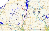
New York State Route 9N (NY 9N) is a north–south state highway
in northeastern New York
, United States
. It extends from an intersection with U.S. Route 9 (US 9), NY 29
, and NY 50
in the city of Saratoga Springs
to a junction with US 9 and NY 22
in the Clinton County
village of Keeseville
. At 143.49 miles (230.92 km) in total length, NY 9N is the longest letter-suffixed route in the state. It is concurrent with its parent route for 1 miles (1.6 km) in the village of Lake George
and for three blocks in the hamlet of Elizabethtown
.
Much of NY 9N runs alongside either a river or a lake. It follows the Hudson River
through northern Saratoga County
and southern Warren County
, the entirety of Lake George
's western shoreline, the west edge of Lake Champlain
between Ticonderoga and Westport
, and the Ausable River from Keene
to Keeseville. The other portions of NY 9N pass through predominantly rural and mountainous regions of the Adirondack Mountains
.
The NY 9N designation was originally created as part of the 1930 renumbering of state highways in New York to replace New York State Route 9W, a route assigned to an alternate routing of US 9 from Elizabethtown to Keeseville. NY 9N was extended southward to Lake George ca. 1936 and to Saratoga Springs in the early 1950s, supplanting several other routes (including New York State Route 9K) in the process.
to Keeseville
. The route stretches through four counties—Saratoga
, Warren
, Essex
and Clinton
—and serves several villages and hamlets, including Lake George
, Ticonderoga, and Elizabethtown
. It overlaps its parent route, US 9, in Lake George and Elizabethtown and meets Interstate 87 (I-87) four times.
westbound, and NY 50
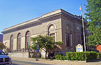
) and Lake Avenue (NY 29 eastbound) in the city of Saratoga Springs
. Situated on the northwestern corner of the junction is the city's post office
. The route heads west, following Church Street out of the city's center. At Bensonhurst Avenue, ownership and maintenance of NY 9N shifts from the city of Saratoga Springs to the New York State Department of Transportation
. As NY 9N exits the city limits and enters the town of Greenfield
, it turns to follow a more northerly routing. It meets County Route 21 (CR 21) just north of the town line and CR 36 (Wilton Road) 2.5 miles (4 km) to the north in the hamlet of Greenfield Center.
 The route continues on into the town of Corinth
, where it crosses the Blue Line
into Adirondack Park. Not far to the north, NY 9N enters the village of Corinth
, situated on the west bank of the Hudson River
. The highway follows Saratoga Avenue and Maple Streets into the village center, where it turns north and exits the village on Main Street. NY 9N follows the western edge of the river north for roughly 4 miles (6 km) through the towns of Corinth and Hadley
before crossing over it and passing from Saratoga County to Warren County.
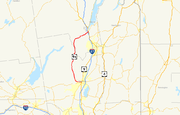
Across the county line in Lake Luzerne
, NY 9N begins to deviate from the Hudson River, gradually curving to the northeast as it passes through the hamlets of Lake Luzerne, Fourth Lake, and Lake Vanare, all of which are named for small lakes bearing those names near the center of the communities. Just northeast of Lake Vanare, NY 9N enters the town of Lake George
, where it connects to I-87
(the Adirondack Northway) at exit 21 and meets US 9.
. The conjoined routes intersect the northern end of NY 9L
just south of the village line before becoming Canada Street and entering the village limits upon crossing over West Brook. US 9 and NY 9N serve as the primary north–south thoroughfare through the village before splitting at the north end of the village. While US 9 continues to the north, NY 9N heads northeast along the western edge of Lake George
.
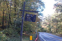
The portion of NY 9N between Lake George village and Hague
is relatively isolated, with mountains lining the western edge of the highway and the lakeshore located to the immediate east. Along this stretch, NY 9N serves numerous lakeside hamlets, the southernmost of which is Diamond Point, a community just south of the Lake George – Bolton
town line. The route continues on, passing through the hamlets of Bolton and Bolton Landing
, the latter of which is home to The Sagamore
, a resort situated on an island in Lake George.
 North of Bolton Landing, the route leaves the main lake and instead follows the edge of Northwest Bay, an inlet separated from Lake George itself by a large, mountainous peninsula. The bay abruptly ends about 2 miles (3.2 km) to the north, at which point NY 9N curves to the east and proceeds through a pass in the mountains to rejoin the western edge of Lake George at Sabbath Day Point in the town of Hague. Here, the route turns back to the north and follows Lake George to the hamlet of Hague, where it meets the northern terminus of NY 8
. NY 9N continues to serve as the lakeside roadway for another 3 miles (5 km) before curving away from the lake and entering Essex County
.
, NY 9N passes through a valley before curving to the east and entering the hamlet of Ticonderoga. For the most part, NY 9N bypasses the community as it turns north onto Wicker Street, the westernmost north–south through street in the hamlet. Northwest of the former village's center, NY 9N meets NY 22
and NY 74
, the latter of which serves as a northerly bypass of Ticonderoga. NY 22 joins NY 9N here, following the route out of the hamlet.
NY 9N and NY 22 head generally northward through an area of lowlands, which eventually give way to Lake Champlain
as the conjoined routes pass into the town of Crown Point
. Once again, NY 9N serves as the lakeside highway as it follows the western edge of the lake through the hamlet of Crown Point to the peninsula that gives the town its name. While NY 9N and NY 22 pass by Crown Point to the west, NY 185
directly serves the peninsula and the Crown Point State Historic Site
, located at its tip.
The routes continue northward along the lakeshore through the town of Moriah
and the village of Port Henry
to the town of Westport
, where NY 9N and NY 22 split in the hamlet of Westport. While NY 22 continues north towards Essex
, NY 9N heads west to follow a more inland routing through a series of narrow valleys. NY 9N intersects I-87 once again at exit 31 just before entering the town of Elizabethtown
. The route continues west, passing over the Bouquet River
and entering the hamlet of Elizabethtown
, where it rejoins US 9 in the former village's center. Unlike the overlap in Lake George, this concurrency lasts for only three blocks before the two routes split.
NY 9N continues to the west for 12 miles (19 km) through deep, narrow valleys to Keene
, where it meets NY 73
north of Keene Valley. Here, NY 9N turns north, joining NY 73 for 2 miles (3.2 km) to the hamlet of Keene, located on the east branch of the Ausable River. NY 73 heads off to the west from this point toward Lake Placid
; however, NY 9N follows the river northward into the town of Jay
, where it intersects the east end of NY 86
. The highway continues alongside the western bank of the river branch to the hamlet of Au Sable Forks
, situated on the Essex–Clinton County
line and at the point where the Ausable River's east and west branches come together.
The highway enters Au Sable Forks from the south on South Main Street and becomes North Main Street upon crossing the west branch of the river and entering Clinton County and the town of Black Brook
. NY 9N immediately turns east upon crossing the river, following Ausable Street out of the hamlet and along the northern edge of the Ausable River into the town of Au Sable
. Here, NY 9N meets I-87 one final time at exit 34 just southwest of the village of Keeseville
. NY 9N continues on into Keeseville, where it meets NY 22 once again at an intersection across the river from the village center. NY 22 and NY 9N come together once more, overlapping for 0.25 mile (0.402335 km) to an intersection with US 9 a short distance downstream from the center of Keeseville. NY 9N comes to an end here while NY 22 turns south onto US 9.
 In 1908, the New York State Legislature created Route 22, an unsigned legislative route
that was initially split into two segments. The northern half of the route ran from Riparius to Rouses Point
and mostly followed what is now US 9 between the two locations. From Elizabethtown
to Keeseville
, however, Route 22 followed a more westerly alignment via Keene
, Jay
, and Au Sable Forks
. When the first set of posted routes in New York
were assigned in 1924, all of legislative Route 22 north of Riparius became part of NY 6, which continued south toward Glens Falls
on what is now US 9. At the same time, the section of modern NY 9N between Saratoga Springs
and Lake George
was designated as part of NY 10
. The portion between Ticonderoga
and Westport
became part of a realigned NY 30 by the following year.
By 1926, the piece of current NY 9N from Hague
to Ticonderoga was designated as the easternmost leg of NY 47, which continued west to Chestertown
on modern NY 8
. In 1927, most of NY 6 north of Round Lake
was replaced by US 9 when U.S. Highways were first signed in New York. The lone exception was between Elizabethtown and Keeseville, where US 9 followed a previously unnumbered highway to the east instead. The bypassed section of NY 6 between the two locations was redesignated as NY 9W at this time. NY 9W was renumbered to NY 9N as part of the 1930 renumbering of state highways in New York, eliminating the alphanumerical duplication between itself and US 9W
.
NY 47, meanwhile, became part of the new NY 8 in the 1930 renumbering, allowing the NY 47 designation to be reassigned to a previously unnumbered roadway along the western shore of Lake George
between NY 8 in Hague and US 9 in Lake George village
. At the same time, NY 10 was realigned south of Long Lake
and replaced with NY 9K from Saratoga Springs to Lake George while the roadway connecting Ticonderoga to Westport became part of NY 22
after NY 30 was reassigned elsewhere in the state. The segment of modern NY 9N from Westport to Elizabethtown, previously unnumbered, was designated NY 195.
NY 9N was extended south to Lake George ca. 1936, supplanting both NY 47 and NY 195. From Westport to Hague
, NY 9N overlapped with NY 22 (from Westport to Ticonderoga) and NY 8 (from Crown Point
to Hague
). The route was extended once more in the early 1950s to its current southern terminus in Saratoga Springs, replacing NY 9K and creating a short overlap with US 9 through Lake George village in the process. The overlap with NY 8 was eliminated in the mid-1960s when that route was truncated to end at its junction with NY 9N in Hague.
State highway
State highway, state road or state route can refer to one of three related concepts, two of them related to a state or provincial government in a country that is divided into states or provinces :#A...
in northeastern New York
New York
New York is a state in the Northeastern region of the United States. It is the nation's third most populous state. New York is bordered by New Jersey and Pennsylvania to the south, and by Connecticut, Massachusetts and Vermont to the east...
, United States
United States
The United States of America is a federal constitutional republic comprising fifty states and a federal district...
. It extends from an intersection with U.S. Route 9 (US 9), NY 29
New York State Route 29
New York State Route 29 is a state highway extending for across the eastern portion of the U.S. state of New York. The western terminus of the route is at NY 28 and NY 169 in Middleville, Herkimer County. The eastern terminus of the route is at NY 22 just south of Salem,...
, and NY 50
New York State Route 50
New York State Route 50 is a state highway in the Capital District of New York in the United States. The southern terminus of the route is at an intersection with NY 5 in Scotia...
in the city of Saratoga Springs
Saratoga Springs, New York
Saratoga Springs, also known as simply Saratoga, is a city in Saratoga County, New York, United States. The population was 26,586 at the 2010 census. The name reflects the presence of mineral springs in the area. While the word "Saratoga" is known to be a corruption of a Native American name, ...
to a junction with US 9 and NY 22
New York State Route 22
New York State Route 22 is a north–south state highway in eastern New York in the United States. It runs parallel to the state's eastern edge from the outskirts of New York City to a short distance south of the Canadian border. At , it is the state's longest north–south route and...
in the Clinton County
Clinton County, New York
Clinton County is a county located in the U.S. state of New York. As of the 2010 census, the population was 82,128. Its name is in honor of the first Governor of New York as a state, George Clinton. Its county seat is Plattsburgh.-History:...
village of Keeseville
Keeseville, New York
Keeseville is a village in both Clinton County, New York and in Essex County, New York in the United States. The population was 1,815 at the 2010 census. The village is named after the Keese family....
. At 143.49 miles (230.92 km) in total length, NY 9N is the longest letter-suffixed route in the state. It is concurrent with its parent route for 1 miles (1.6 km) in the village of Lake George
Lake George (village), New York
The Village of Lake George is a village within the town of Lake George in Warren County, New York, United States. The population was 985 at the 2000 census. It is part of the Glens Falls Metropolitan Statistical Area...
and for three blocks in the hamlet of Elizabethtown
Elizabethtown (hamlet), New York
Elizabethtown is a hamlet in the town of Elizabethtown in Essex County, New York, United States. Many locals in the town, as well as those who surround the area call Elizabethtown, E-Town....
.
Much of NY 9N runs alongside either a river or a lake. It follows the Hudson River
Hudson River
The Hudson is a river that flows from north to south through eastern New York. The highest official source is at Lake Tear of the Clouds, on the slopes of Mount Marcy in the Adirondack Mountains. The river itself officially begins in Henderson Lake in Newcomb, New York...
through northern Saratoga County
Saratoga County, New York
Saratoga County is a county located in the U.S. state of New York. As of the 2010 census, the population was 219,607. It is part of the Albany-Schenectady-Troy Metropolitan Statistical Area. The county seat is Ballston Spa...
and southern Warren County
Warren County, New York
Warren County is a county in the U.S. state of New York. It is part of the Glens Falls, New York, Metropolitan Statistical Area. As of the 2010 census, the population was 65,707. It is named in honor of General Joseph Warren, an American Revolutionary War hero of the Battle of Bunker Hill...
, the entirety of Lake George
Lake George (New York)
Lake George, nicknamed the Queen of American Lakes, is a long, narrow oligotrophic lake draining northwards into Lake Champlain and the St. Lawrence River Drainage basin located at the southeast base of the Adirondack Mountains in northern New York, U.S.A.. It lies within the upper region of the...
's western shoreline, the west edge of Lake Champlain
Lake Champlain
Lake Champlain is a natural, freshwater lake in North America, located mainly within the borders of the United States but partially situated across the Canada—United States border in the Canadian province of Quebec.The New York portion of the Champlain Valley includes the eastern portions of...
between Ticonderoga and Westport
Westport, New York
Westport is a town in Essex County, New York, United States overlooking Lake Champlain. The population was 1,362 at the 2000 census.The Town of Westport is on the eastern border of the county and is south of Plattsburgh and south of Montreal. Westport is inside the Adirondack Park.Westport is...
, and the Ausable River from Keene
Keene, New York
Keene is a town in central Essex County, New York, United States. The population was 1,063 at the 2000 census. Keene is the home of Mount Marcy, the highest mountain in New York state, as well as the Great Range and 15 of the 46 High Peaks, and the Ausable Lakes, the source of the Ausable River...
to Keeseville. The other portions of NY 9N pass through predominantly rural and mountainous regions of the Adirondack Mountains
Adirondack Mountains
The Adirondack Mountains are a mountain range located in the northeastern part of New York, that runs through Clinton, Essex, Franklin, Fulton, Hamilton, Herkimer, Lewis, Saint Lawrence, Saratoga, Warren, and Washington counties....
.
The NY 9N designation was originally created as part of the 1930 renumbering of state highways in New York to replace New York State Route 9W, a route assigned to an alternate routing of US 9 from Elizabethtown to Keeseville. NY 9N was extended southward to Lake George ca. 1936 and to Saratoga Springs in the early 1950s, supplanting several other routes (including New York State Route 9K) in the process.
Route description
NY 9N is the longest suffixed route in the state, extending for 143.5 miles (230.9 km) from Saratoga SpringsSaratoga Springs, New York
Saratoga Springs, also known as simply Saratoga, is a city in Saratoga County, New York, United States. The population was 26,586 at the 2010 census. The name reflects the presence of mineral springs in the area. While the word "Saratoga" is known to be a corruption of a Native American name, ...
to Keeseville
Keeseville, New York
Keeseville is a village in both Clinton County, New York and in Essex County, New York in the United States. The population was 1,815 at the 2010 census. The village is named after the Keese family....
. The route stretches through four counties—Saratoga
Saratoga County, New York
Saratoga County is a county located in the U.S. state of New York. As of the 2010 census, the population was 219,607. It is part of the Albany-Schenectady-Troy Metropolitan Statistical Area. The county seat is Ballston Spa...
, Warren
Warren County, New York
Warren County is a county in the U.S. state of New York. It is part of the Glens Falls, New York, Metropolitan Statistical Area. As of the 2010 census, the population was 65,707. It is named in honor of General Joseph Warren, an American Revolutionary War hero of the Battle of Bunker Hill...
, Essex
Essex County, New York
Essex County is a county located in the U.S. state of New York. As of the 2010 census, the population was 39,370. Its name is from the English county of Essex. Its county seat is Elizabethtown...
and Clinton
Clinton County, New York
Clinton County is a county located in the U.S. state of New York. As of the 2010 census, the population was 82,128. Its name is in honor of the first Governor of New York as a state, George Clinton. Its county seat is Plattsburgh.-History:...
—and serves several villages and hamlets, including Lake George
Lake George (village), New York
The Village of Lake George is a village within the town of Lake George in Warren County, New York, United States. The population was 985 at the 2000 census. It is part of the Glens Falls Metropolitan Statistical Area...
, Ticonderoga, and Elizabethtown
Elizabethtown (hamlet), New York
Elizabethtown is a hamlet in the town of Elizabethtown in Essex County, New York, United States. Many locals in the town, as well as those who surround the area call Elizabethtown, E-Town....
. It overlaps its parent route, US 9, in Lake George and Elizabethtown and meets Interstate 87 (I-87) four times.
South of Lake George
NY 9N begins at the intersection of Church Street, Broadway (US 9, NY 29New York State Route 29
New York State Route 29 is a state highway extending for across the eastern portion of the U.S. state of New York. The western terminus of the route is at NY 28 and NY 169 in Middleville, Herkimer County. The eastern terminus of the route is at NY 22 just south of Salem,...
westbound, and NY 50
New York State Route 50
New York State Route 50 is a state highway in the Capital District of New York in the United States. The southern terminus of the route is at an intersection with NY 5 in Scotia...
) and Lake Avenue (NY 29 eastbound) in the city of Saratoga Springs
Saratoga Springs, New York
Saratoga Springs, also known as simply Saratoga, is a city in Saratoga County, New York, United States. The population was 26,586 at the 2010 census. The name reflects the presence of mineral springs in the area. While the word "Saratoga" is known to be a corruption of a Native American name, ...
. Situated on the northwestern corner of the junction is the city's post office
U.S. Post Office (Saratoga Springs, New York)
The U.S. Post Office in Saratoga Springs, New York, United States, is located at the junction of Broadway and Church Street in the center of the city. It is an early 20th-century brick structure in the Classical Revival architectural style, designed by James Knox Taylor, supervising architect for...
. The route heads west, following Church Street out of the city's center. At Bensonhurst Avenue, ownership and maintenance of NY 9N shifts from the city of Saratoga Springs to the New York State Department of Transportation
New York State Department of Transportation
The New York State Department of Transportation is responsible for the development and operation of highways, railroads, mass transit systems, ports, waterways and aviation facilities in the U.S...
. As NY 9N exits the city limits and enters the town of Greenfield
Greenfield, New York
Greenfield is a town in Saratoga County, New York, United States. The population was 7,362 at the 2000 census. The town is named after Greenfield, New Hampshire.The Town of Greenfield is an interior town...
, it turns to follow a more northerly routing. It meets County Route 21 (CR 21) just north of the town line and CR 36 (Wilton Road) 2.5 miles (4 km) to the north in the hamlet of Greenfield Center.
Corinth (town), New York
Corinth is a town in Saratoga County, New York, USA. The population was 5,985 at the 2000 census. The town contains a village also named Corinth. The town is on the northeast border of the county, north of Saratoga Springs. It regards itself as the "snowshoe capital of the world." The town is named...
, where it crosses the Blue Line
Blue Line (New York State)
The Blue Line is the term used in New York state for the boundaries of the Adirondack and Catskill parks, within which can be found the state's Forest Preserve...
into Adirondack Park. Not far to the north, NY 9N enters the village of Corinth
Corinth (village), New York
Corinth is a village in Saratoga County, New York, USA. The population was 2,474 at the 2000 census. The village gets its name from the Greek city of Corinth.The Village of Corinth is by the east town line of the Town of Corinth...
, situated on the west bank of the Hudson River
Hudson River
The Hudson is a river that flows from north to south through eastern New York. The highest official source is at Lake Tear of the Clouds, on the slopes of Mount Marcy in the Adirondack Mountains. The river itself officially begins in Henderson Lake in Newcomb, New York...
. The highway follows Saratoga Avenue and Maple Streets into the village center, where it turns north and exits the village on Main Street. NY 9N follows the western edge of the river north for roughly 4 miles (6 km) through the towns of Corinth and Hadley
Hadley, New York
Hadley is a town in Saratoga County, New York, United States. The population was 1,971 at the 2000 census. The town was named after Hadley, Massachusetts.The Town of Hadley is in the northern part of the county and is west of Glens Falls....
before crossing over it and passing from Saratoga County to Warren County.
Across the county line in Lake Luzerne
Lake Luzerne, New York
Lake Luzerne is a town in southern Warren County, New York, United States. The town is located within the Adirondack Park. The town is part of the Glens Falls Metropolitan Statistical Area. Lake Luzerne is west of the city of Glens Falls. The town population was 3,219 at the 2000 census.- History...
, NY 9N begins to deviate from the Hudson River, gradually curving to the northeast as it passes through the hamlets of Lake Luzerne, Fourth Lake, and Lake Vanare, all of which are named for small lakes bearing those names near the center of the communities. Just northeast of Lake Vanare, NY 9N enters the town of Lake George
Lake George (town), New York
Lake George is a town in Warren County, New York, USA. The population was 3,578 at the 2000 census. The town is named after the lake, Lake George. Within the town is a village also named Lake George. The town is part of the Glens Falls Metropolitan Statistical Area.- History :The lake was...
, where it connects to I-87
Interstate 87
Interstate 87 is a Interstate Highway located entirely within New York State in the United States of America. I-87 is the longest intrastate Interstate highway in the Interstate Highway System. Its southern end is at the Bronx approaches of the Robert F. Kennedy Bridge in New York City...
(the Adirondack Northway) at exit 21 and meets US 9.
Lake George area
NY 9N turns north at US 9, joining its parent route northward toward the village of Lake GeorgeLake George (village), New York
The Village of Lake George is a village within the town of Lake George in Warren County, New York, United States. The population was 985 at the 2000 census. It is part of the Glens Falls Metropolitan Statistical Area...
. The conjoined routes intersect the northern end of NY 9L
New York State Route 9L
New York State Route 9L is a state highway in Warren County, New York, in the United States. The road is long and is a suffixed highway of U.S. Route 9 . NY 9L goes through three municipalities in Warren County: the city of Glens Falls, the town of Queensbury and the town of Lake...
just south of the village line before becoming Canada Street and entering the village limits upon crossing over West Brook. US 9 and NY 9N serve as the primary north–south thoroughfare through the village before splitting at the north end of the village. While US 9 continues to the north, NY 9N heads northeast along the western edge of Lake George
Lake George (New York)
Lake George, nicknamed the Queen of American Lakes, is a long, narrow oligotrophic lake draining northwards into Lake Champlain and the St. Lawrence River Drainage basin located at the southeast base of the Adirondack Mountains in northern New York, U.S.A.. It lies within the upper region of the...
.
The portion of NY 9N between Lake George village and Hague
Hague, New York
Hague is a town in northeastern Warren County, New York, United States located on the scenic Lake George. It is part of the Glens Falls Metropolitan Statistical Area. The population was 854 at the 2000 census...
is relatively isolated, with mountains lining the western edge of the highway and the lakeshore located to the immediate east. Along this stretch, NY 9N serves numerous lakeside hamlets, the southernmost of which is Diamond Point, a community just south of the Lake George – Bolton
Bolton, New York
Bolton is a town in Warren County, New York, United States. It is part of the Glens Falls Metropolitan Statistical Area. The population was 2,117 at the 2000 census. Bolton is on the east border of the county.- History :...
town line. The route continues on, passing through the hamlets of Bolton and Bolton Landing
Bolton Landing, New York
Bolton Landing is a hamlet in the town of Bolton in Warren County, New York, United States. It is located on Lake George in the Adirondack Mountains. It is a common tourist destination and the closest town to the State Park lands and islands of the Lake George Narrows...
, the latter of which is home to The Sagamore
The Sagamore
The Sagamore is a Victorian era resort hotel located on Lake George in Bolton Landing, New York. The name Sagamore is taken from the title for the chief of a Native American tribe. The Sagamore of the Mohicans was a featured character in James Fenimore Cooper's The Last of the Mohicans, many...
, a resort situated on an island in Lake George.
New York State Route 8
New York State Route 8 is a state highway in the central part of New York in the United States. It runs in a southwest-to-northeast direction from the Southern Tier to the northern part of Lake George. The southern terminus of the route is at an interchange with NY 17 in the town of...
. NY 9N continues to serve as the lakeside roadway for another 3 miles (5 km) before curving away from the lake and entering Essex County
Essex County, New York
Essex County is a county located in the U.S. state of New York. As of the 2010 census, the population was 39,370. Its name is from the English county of Essex. Its county seat is Elizabethtown...
.
Essex and Clinton Counties
Now in the town of TiconderogaTiconderoga, New York
Ticonderoga is a town in Essex County, New York, USA. The population was 5,167 at the 2000 census. The name comes from the Mohawk tekontaró:ken, meaning "it is at the junction of two waterways"....
, NY 9N passes through a valley before curving to the east and entering the hamlet of Ticonderoga. For the most part, NY 9N bypasses the community as it turns north onto Wicker Street, the westernmost north–south through street in the hamlet. Northwest of the former village's center, NY 9N meets NY 22
New York State Route 22
New York State Route 22 is a north–south state highway in eastern New York in the United States. It runs parallel to the state's eastern edge from the outskirts of New York City to a short distance south of the Canadian border. At , it is the state's longest north–south route and...
and NY 74
New York State Route 74
New York State Route 74 and Vermont Route 74 are adjoining state highways in the northeastern United States, connected by one of the last remaining cable ferries in North America. Together they extend for through Essex County, New York, and Addison County, Vermont...
, the latter of which serves as a northerly bypass of Ticonderoga. NY 22 joins NY 9N here, following the route out of the hamlet.
NY 9N and NY 22 head generally northward through an area of lowlands, which eventually give way to Lake Champlain
Lake Champlain
Lake Champlain is a natural, freshwater lake in North America, located mainly within the borders of the United States but partially situated across the Canada—United States border in the Canadian province of Quebec.The New York portion of the Champlain Valley includes the eastern portions of...
as the conjoined routes pass into the town of Crown Point
Crown Point, New York
Crown Point is a town in Essex County, New York, USA. The population was 2,119 at the 2000 census. The name of the town is a direct translation of the original French name, "Point au Chevalure."...
. Once again, NY 9N serves as the lakeside highway as it follows the western edge of the lake through the hamlet of Crown Point to the peninsula that gives the town its name. While NY 9N and NY 22 pass by Crown Point to the west, NY 185
New York State Route 185
New York State Route 185 was a state highway located within St. Lawrence County in the North Country of New York in the United States. Although the route followed a mostly north–south alignment, it was considered an east–west highway by the New York State Department of Transportation...
directly serves the peninsula and the Crown Point State Historic Site
Crown Point State Historic Site
Crown Point State Historic Site is the site of a former military stronghold at the south end of the wider part of Lake Champlain. The location is in Essex County, New York, USA. The site is on a peninsula in the town of Crown Point, New York....
, located at its tip.
The routes continue northward along the lakeshore through the town of Moriah
Moriah, New York
Moriah is a town in Essex County, New York, United States. The population was 4,879 at the 2000 census.The Town of Moriah is in the eastern part of the county. It is south-southwest of Burlington, VT, south of Plattsburgh, north of Albany, NY, and south of Montreal, Quebec...
and the village of Port Henry
Port Henry, New York
Port Henry is a village in Essex County, New York, United States. The population was 1,152 at the 2000 census.The Village of Port Henry lies on the east side of the Town of Moriah and is approximately one hour's drive south of Plattsburgh...
to the town of Westport
Westport, New York
Westport is a town in Essex County, New York, United States overlooking Lake Champlain. The population was 1,362 at the 2000 census.The Town of Westport is on the eastern border of the county and is south of Plattsburgh and south of Montreal. Westport is inside the Adirondack Park.Westport is...
, where NY 9N and NY 22 split in the hamlet of Westport. While NY 22 continues north towards Essex
Essex, New York
Essex is a town in Essex County, New York, United States overlooking Lake Champlain. The population was 713 at the 2000 census. The town is named after locations in England.The Town of Essex is on the eastern edge of the county...
, NY 9N heads west to follow a more inland routing through a series of narrow valleys. NY 9N intersects I-87 once again at exit 31 just before entering the town of Elizabethtown
Elizabethtown, New York
Elizabethtown is a town in Essex County, New York, United States. The population was 1,315 at the 2000 census. The county seat of Essex County is a hamlet also called Elizabethtown. The name is derived from Elizabeth Gilliland, the wife of an early settler....
. The route continues west, passing over the Bouquet River
Bouquet River
The Boquet River is a small river in upstate New York, USA. The river flows into Lake Champlain at the east border of the Town of Willsboro in Essex County....
and entering the hamlet of Elizabethtown
Elizabethtown, New York
Elizabethtown is a town in Essex County, New York, United States. The population was 1,315 at the 2000 census. The county seat of Essex County is a hamlet also called Elizabethtown. The name is derived from Elizabeth Gilliland, the wife of an early settler....
, where it rejoins US 9 in the former village's center. Unlike the overlap in Lake George, this concurrency lasts for only three blocks before the two routes split.
NY 9N continues to the west for 12 miles (19 km) through deep, narrow valleys to Keene
Keene, New York
Keene is a town in central Essex County, New York, United States. The population was 1,063 at the 2000 census. Keene is the home of Mount Marcy, the highest mountain in New York state, as well as the Great Range and 15 of the 46 High Peaks, and the Ausable Lakes, the source of the Ausable River...
, where it meets NY 73
New York State Route 73
New York State Route 73 is a state highway located entirely within Essex County, New York, United States. The highway begins at an intersection with NY 86 in the village of Lake Placid and ends at a junction with U.S. Route 9 north of the hamlet of Underwood in the extreme...
north of Keene Valley. Here, NY 9N turns north, joining NY 73 for 2 miles (3.2 km) to the hamlet of Keene, located on the east branch of the Ausable River. NY 73 heads off to the west from this point toward Lake Placid
Lake Placid, New York
Lake Placid is a village in the Adirondack Mountains in Essex County, New York, United States. As of the 2000 census, the village had a population of 2,638....
; however, NY 9N follows the river northward into the town of Jay
Jay, New York
Jay is a town in Essex County, New York, United States. The population was 2,306 at the 2000 census. The town is named after John Jay, governor of New York when the town was formed....
, where it intersects the east end of NY 86
New York State Route 86
New York State Route 86 is a long state highway located within Adirondack Park in northern New York, United States, linking Franklin County to Essex County. The western terminus of the route is at NY 30 in the hamlet of Paul Smiths. The eastern terminus is at NY 9N in Jay...
. The highway continues alongside the western bank of the river branch to the hamlet of Au Sable Forks
Au Sable Forks, New York
Au Sable Forks is a census-designated place in Clinton County, New York, United States. The population was 559 at the 2010 census.-Geography:Au Sable Forks is located at ....
, situated on the Essex–Clinton County
Clinton County, New York
Clinton County is a county located in the U.S. state of New York. As of the 2010 census, the population was 82,128. Its name is in honor of the first Governor of New York as a state, George Clinton. Its county seat is Plattsburgh.-History:...
line and at the point where the Ausable River's east and west branches come together.
The highway enters Au Sable Forks from the south on South Main Street and becomes North Main Street upon crossing the west branch of the river and entering Clinton County and the town of Black Brook
Black Brook, New York
Black Brook is a town in Clinton County, New York, United States. The population was 1,497 at the 2010 census. The town is named after an important waterway in the town....
. NY 9N immediately turns east upon crossing the river, following Ausable Street out of the hamlet and along the northern edge of the Ausable River into the town of Au Sable
Au Sable, New York
Au Sable, or Ausable, is a town in Clinton County, New York, United States. The population was 3,146 at the 2010 census. The name is from a river that flows through the town and means "Of the sand."...
. Here, NY 9N meets I-87 one final time at exit 34 just southwest of the village of Keeseville
Keeseville, New York
Keeseville is a village in both Clinton County, New York and in Essex County, New York in the United States. The population was 1,815 at the 2010 census. The village is named after the Keese family....
. NY 9N continues on into Keeseville, where it meets NY 22 once again at an intersection across the river from the village center. NY 22 and NY 9N come together once more, overlapping for 0.25 mile (0.402335 km) to an intersection with US 9 a short distance downstream from the center of Keeseville. NY 9N comes to an end here while NY 22 turns south onto US 9.
History
Legislative route
In United States, a legislative route or legislative highway is a highway defined by laws passed in a state legislature. The numbering of such highways may or may not correspond to the numbers familiar to the public as part of the state, U.S. highway, and Interstate highway systems...
that was initially split into two segments. The northern half of the route ran from Riparius to Rouses Point
Rouses Point, New York
Rouses Point is a village in Clinton County, New York, United States, along the 45th parallel. The population was 2,209 at the 2010 census. The village is named after Jacques Rouse, an early settler....
and mostly followed what is now US 9 between the two locations. From Elizabethtown
Elizabethtown (hamlet), New York
Elizabethtown is a hamlet in the town of Elizabethtown in Essex County, New York, United States. Many locals in the town, as well as those who surround the area call Elizabethtown, E-Town....
to Keeseville
Keeseville, New York
Keeseville is a village in both Clinton County, New York and in Essex County, New York in the United States. The population was 1,815 at the 2010 census. The village is named after the Keese family....
, however, Route 22 followed a more westerly alignment via Keene
Keene, New York
Keene is a town in central Essex County, New York, United States. The population was 1,063 at the 2000 census. Keene is the home of Mount Marcy, the highest mountain in New York state, as well as the Great Range and 15 of the 46 High Peaks, and the Ausable Lakes, the source of the Ausable River...
, Jay
Jay, New York
Jay is a town in Essex County, New York, United States. The population was 2,306 at the 2000 census. The town is named after John Jay, governor of New York when the town was formed....
, and Au Sable Forks
Au Sable Forks, New York
Au Sable Forks is a census-designated place in Clinton County, New York, United States. The population was 559 at the 2010 census.-Geography:Au Sable Forks is located at ....
. When the first set of posted routes in New York
New York
New York is a state in the Northeastern region of the United States. It is the nation's third most populous state. New York is bordered by New Jersey and Pennsylvania to the south, and by Connecticut, Massachusetts and Vermont to the east...
were assigned in 1924, all of legislative Route 22 north of Riparius became part of NY 6, which continued south toward Glens Falls
Glens Falls, New York
Glens Falls is a city in Warren County, New York, United States. Glens Falls Metropolitan Statistical Area. The population was 14,700 at the 2010 census...
on what is now US 9. At the same time, the section of modern NY 9N between Saratoga Springs
Saratoga Springs, New York
Saratoga Springs, also known as simply Saratoga, is a city in Saratoga County, New York, United States. The population was 26,586 at the 2010 census. The name reflects the presence of mineral springs in the area. While the word "Saratoga" is known to be a corruption of a Native American name, ...
and Lake George
Lake George (village), New York
The Village of Lake George is a village within the town of Lake George in Warren County, New York, United States. The population was 985 at the 2000 census. It is part of the Glens Falls Metropolitan Statistical Area...
was designated as part of NY 10
New York State Route 10
New York State Route 10 is a north–south state highway in the Central New York and North Country regions of New York in the United States. It extends for from the Quickway in Deposit, Delaware County to NY 8 at Higgins Bay, a hamlet in the Hamilton County town of Arietta...
. The portion between Ticonderoga
Ticonderoga, New York
Ticonderoga is a town in Essex County, New York, USA. The population was 5,167 at the 2000 census. The name comes from the Mohawk tekontaró:ken, meaning "it is at the junction of two waterways"....
and Westport
Westport, New York
Westport is a town in Essex County, New York, United States overlooking Lake Champlain. The population was 1,362 at the 2000 census.The Town of Westport is on the eastern border of the county and is south of Plattsburgh and south of Montreal. Westport is inside the Adirondack Park.Westport is...
became part of a realigned NY 30 by the following year.
By 1926, the piece of current NY 9N from Hague
Hague, New York
Hague is a town in northeastern Warren County, New York, United States located on the scenic Lake George. It is part of the Glens Falls Metropolitan Statistical Area. The population was 854 at the 2000 census...
to Ticonderoga was designated as the easternmost leg of NY 47, which continued west to Chestertown
Chestertown, New York
Chestertown is a hamlet in Warren County, New York, United States, in the Adirondack Mountains, in the Town of Chester. The population was 2,187 at the 2000 census. The community is located by the junction of Route 8 and U.S. Route 9....
on modern NY 8
New York State Route 8
New York State Route 8 is a state highway in the central part of New York in the United States. It runs in a southwest-to-northeast direction from the Southern Tier to the northern part of Lake George. The southern terminus of the route is at an interchange with NY 17 in the town of...
. In 1927, most of NY 6 north of Round Lake
Round Lake, New York
Round Lake is a lake and a village in Saratoga County, New York, United States. The population was 604 at the 2000 census. The name is derived from a circular lake adjacent to the village...
was replaced by US 9 when U.S. Highways were first signed in New York. The lone exception was between Elizabethtown and Keeseville, where US 9 followed a previously unnumbered highway to the east instead. The bypassed section of NY 6 between the two locations was redesignated as NY 9W at this time. NY 9W was renumbered to NY 9N as part of the 1930 renumbering of state highways in New York, eliminating the alphanumerical duplication between itself and US 9W
U.S. Route 9W
U.S. Route 9W is a north–south U.S. Highway in the states of New Jersey and New York. It begins on Fletcher Avenue in Fort Lee, New Jersey as it crosses the US 1 & 9, US 46, and the Interstate 95 approaches to the George Washington Bridge, where it heads north up the west...
.
NY 47, meanwhile, became part of the new NY 8 in the 1930 renumbering, allowing the NY 47 designation to be reassigned to a previously unnumbered roadway along the western shore of Lake George
Lake George (New York)
Lake George, nicknamed the Queen of American Lakes, is a long, narrow oligotrophic lake draining northwards into Lake Champlain and the St. Lawrence River Drainage basin located at the southeast base of the Adirondack Mountains in northern New York, U.S.A.. It lies within the upper region of the...
between NY 8 in Hague and US 9 in Lake George village
Lake George (village), New York
The Village of Lake George is a village within the town of Lake George in Warren County, New York, United States. The population was 985 at the 2000 census. It is part of the Glens Falls Metropolitan Statistical Area...
. At the same time, NY 10 was realigned south of Long Lake
Long Lake, New York
Long Lake is a town in Hamilton County, New York in the United States. The population was 852 at the 2000 census. The town is named for long Long Lake beside which it sits. The town is entirely within the Adirondack Park and is the most northerly town in the county. It is a summer tourism...
and replaced with NY 9K from Saratoga Springs to Lake George while the roadway connecting Ticonderoga to Westport became part of NY 22
New York State Route 22
New York State Route 22 is a north–south state highway in eastern New York in the United States. It runs parallel to the state's eastern edge from the outskirts of New York City to a short distance south of the Canadian border. At , it is the state's longest north–south route and...
after NY 30 was reassigned elsewhere in the state. The segment of modern NY 9N from Westport to Elizabethtown, previously unnumbered, was designated NY 195.
NY 9N was extended south to Lake George ca. 1936, supplanting both NY 47 and NY 195. From Westport to Hague
Hague, New York
Hague is a town in northeastern Warren County, New York, United States located on the scenic Lake George. It is part of the Glens Falls Metropolitan Statistical Area. The population was 854 at the 2000 census...
, NY 9N overlapped with NY 22 (from Westport to Ticonderoga) and NY 8 (from Crown Point
Crown Point, New York
Crown Point is a town in Essex County, New York, USA. The population was 2,119 at the 2000 census. The name of the town is a direct translation of the original French name, "Point au Chevalure."...
to Hague
Hague, New York
Hague is a town in northeastern Warren County, New York, United States located on the scenic Lake George. It is part of the Glens Falls Metropolitan Statistical Area. The population was 854 at the 2000 census...
). The route was extended once more in the early 1950s to its current southern terminus in Saratoga Springs, replacing NY 9K and creating a short overlap with US 9 through Lake George village in the process. The overlap with NY 8 was eliminated in the mid-1960s when that route was truncated to end at its junction with NY 9N in Hague.