
New York State Route 149
Encyclopedia
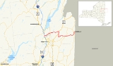
New York State Route 149 (NY 149) is an east–west state highway
that runs for 32.2 miles (51.82 km) through the Capital District
of New York
in the United States. It begins at exit 20 on the Adirondack Northway (Interstate 87 or I-87) in the Warren County
town of Queensbury
and intersects U.S. Route 9 (US 9), US 4
, and NY 22
, among other routes, as it progresses eastward to its eastern end at the Vermont
state line in the Washington County
village of Granville
. Here, the highway becomes Vermont Route 149 (VT 149) and continues for an additional 1.302 miles (2.095 km) to an intersection with VT 30
in Rutland County. Both NY 149 and VT 149 traverse mostly rural areas.
NY 149 was assigned in the 1930 renumbering of state highways in New York and initially extended from NY 9L
in Queensbury to NY 22 south of Granville by way of an east–west highway built during the first two decades of the 20th century. It was cut back to US 4 ca. 1939, but extended westward back to NY 9L in the mid-1950s. It was extended further west to US 9 in the late 1950s and to I-87 exit 20 ca. 1962. In the mid-1960s, NY 22 was rerouted to bypass Granville to the west. NY 149 was then extended to Vermont by way of NY 22's former routing into the village and East Main Street. The short continuation of Granville's East Main Street in Vermont, designated as Vermont Route 30B since 1935, was renumbered to VT 149 at this time to match the New York number.
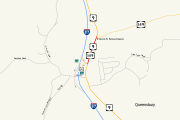
) in the town of Queensbury
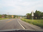
, from where it follows a ramp eastward to US 9. As signed, however, NY 149 begins at the southbound portion of I-87 exit 20 and follows Gurney Lane east to US 9, where it turns to follow US 9 northward. The signed and official routings join at the exit's northbound ramps. While concurrent with US 9, NY 149 passes the Adirondack/Lake George Factory Outlet Mall and several other businesses located on both sides of the highway. At the end of the factory outlets in the hamlet of French Mountain, NY 149 turns off US 9 and proceeds in a generally eastward direction toward the village of Fort Ann
.
After passing under a bike path overpass and a recreational vehicle
park, the route runs through an area of rural residential dwellings and wooded areas situated north of Glen Lake. At the northern tip of the lake, NY 149 intersects Oxbow Hill Road, a connector to County Route 63 (CR 63, named Moon Hill Road) that is maintained by Warren County
county despite not being a numbered Warren County route. East of this junction, the highway turns to the northeast and crosses the Blue Line
into Adirondack Park ahead of an intersection with CR 7 (Bay Road). NY 149 continues on, curving back to the east as it passes the Queensbury Country Club and meets NY 9L
. The route enters Washington County
and the town of Fort Ann
roughly 0.5 mile (0.80467 km) later.
The first several miles of NY 149 in Washington County pass through isolated, rural areas as it curves to the north and south while following a generally east–west alignment. In West Fort Ann, the only community along the route between the county line and the village of Fort Ann, NY 149 intersects with Old State Route 149, a loop route of NY 149 that was created when the highway was realigned. The route continues east from the community, exiting Adirondack Park and crossing over Halfway Creek on its way into the village of Fort Ann, where it becomes Ann Street. Within the village, NY 149 passes the Fort Ann Cemetery and two blocks of homes before intersecting with US 4
at George Street. NY 149 turns to the south, joining US 4 along George Street through downtown Fort Ann. After passing the town park, US 4 and NY 149 leave the village and become nameless as they head south into the town of Kingsbury
.
to an area known as Smith's Basin. Here, NY 149 turns east and crosses both a railroad line and the canal—which NY 149 had been following since joining US 4 in downtown Fort Ann—to enter the town of Hartford
. Here, the route winds its way eastward through a rural, mostly undeveloped area of Washington County as it intersects several county roads on its way to the hamlet of Hartford.
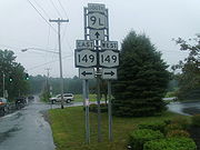
In Hartford, NY 149 intersects both Christian Hill Road and CR 23 (the main street of the community) ahead of a junction with NY 40
south of the community. The two routes converge here as NY 149 follows NY 40 northward around the small community to a junction east of the hamlet's center, where NY 149 turns off to the east and begins to pass through more rural areas of the town of Hartford and the adjacent town of Granville. Upon crossing into Granville, the open areas along the route give way to dense forests. NY 149 continues generally northeastward through the town, passing through the isolated hamlet of Hillsdale before curving to the southeast toward South Granville. At the center of the community, NY 149 turns to the northeast at an intersection with CR 27 and CR 28.
The route leaves South Granville, passing patches of trees and a smattering of homes as it heads toward the border village of Granville
. Just south of the village limits, NY 149 intersects with NY 22
. Routes 22 and 149 briefly overlap before NY 22 forks off to bypass Granville to the west. NY 149 continues into Granville, becoming Quaker Street upon entering the village limits. The route proceeds through the village to its center, where NY 149 forks northeastward onto West Main Street and crosses over the Mettawee River
. At an intersection with Church Street (CR 26), NY 149 becomes East Main Street and turns to the southeast on its way to the Vermont
state line, where the roadway becomes VT 149.
VT 149 heads southeastward away from the built up village of Granville into a more rural region of the Rutland County town of Pawlet
, paralleling the Mettawee River as it progresses onward. It heads past homes and through a dense forest as it intersects with Bull Frog Hollow Road just after the border. After Bull Frog Hollow Road, the route proceeds eastward through an area dominated by quarries. VT 149 continues on, entering a more open area and passing only a few homes before ending at an intersection with VT 30
in Blossom Corners, a small, largely unpopulated community within the town of Pawlet.
 Several portions of NY 149 were constructed during the early 20th century when the state of New York
assumed ownership over thousands of highways across the state. The earliest known constructed portion of modern NY 149 is the segment between the southern end of the NY 22
overlap and the southern village limits of Granville
. The state let a $10,850 (equivalent to $ in ) contract to improve the highway, legislatively designated as part of State Highway 104 (SH 104), on May 12, 1902. The highway was added to the state highway system on October 6, 1902, following the completion of the project. The portion of NY 149 that overlaps US 9 in Queensbury, designated as part of SH 417, was improved under the terms of a $82,700 (equivalent to $ in ) contract awarded on July 10, 1906. It was added to the state highway system on January 10, 1907.
Other portions of modern NY 149 were constructed over the course of the next decade. In 1911, work began on the section of current NY 149 between Smith's Basin and the northern junction with NY 40 in Hartford
. The contract for the portion in the town of Fort Ann
(SH 942) was let on June 15 while the contract for the section in Hartford (SH 802) was awarded three months earlier on March 30. The two projects were carried out simultaneously over the next two years. SH 802 was added to the state highway system on February 9, 1914, while SH 942 was included in the system on May 5, 1914. In all, the improvement of the two state highways cost $69,577.20 (equivalent to $ in ).
In 1913, construction began on the portion of what is now NY 149 in Granville south of North Street, internally designated as SH 5404. The $77,684.89 (equivalent to $ in ) contract was awarded on September 5, 1913. The necessary improvements were made over the course of the next year and the highway was incorporated into the state highway system on October 29, 1914. The last portion of NY 149 with a known construction date is the section concurrent to US 4
in Fort Ann (part of SH 1224). A contract for its improvement was let on January 8, 1915 at a cost of $43,778.92 (equivalent to $ in ). The improvements were made over the next year and the roadway was added to the state highway system on January 10, 1916.
 When the first set of New York state routes were assigned in 1924, SH 417 became part of NY 6 while SH 104 and SH 5404 were included in NY 24 and SH 1224 was designated as part of NY 30. NY 6 was replaced by US 9 while NY 30 was co-designated as US 4 between Glens Falls
and Whitehall
in 1927 following the creation of the U.S. Highway System in late 1926. The remainder of modern NY 149 was unnumbered prior to 1930.
in Queensbury
and NY 22 south of the village of Granville
. In July 1935, several floods devastated many highways in the state of New York
. One highway affected was NY 149, as a bridge carrying the highway in the hamlet of South Granville was washed out. With the bridge out, drivers were detoured onto a town highway (now maintained by Washington County
as CR 27) to access NY 22 and Granville from South Granville and to access NY 40
from Granville. NY 22 was also affected by the flood as a bridge in the town of Cambridge
was washed out as well.
NY 149 was truncated eastward ca. 1939 to the southern terminus of its overlap with US 4 south of Fort Ann. The change lasted for roughly 15 years before the highway was reextended westward to NY 9L in the mid-1950s. It was extended again in the late 1950s to follow a pre-existing, unnumbered roadway west to US 9 in the Queensbury hamlet of French Mountain. NY 149 was altered once more ca. 1962 to meet the new I-87
at exit 20, resulting in a short overlap with US 9.
 In Granville, NY 22 was originally routed on on Quaker, Main, and North Streets. It was rerouted in the mid-1960s to bypass Granville on a new highway west of the village. NY 149 was then extended northward along NY 22's former routing to the junction of Main and North Streets in Granville. From there, it continued eastward on Main Street to reach the Vermont
state line, where it connected to VT 30B, a spur route of VT 30
that had been in place since 1935. Vermont renumbered VT 30B to VT 149 at this time to match the highway it now connected to in New York.
(NYSDOT) $1.5 million (equivalent to $ in ).
In 2007, the Times Union of Albany
received letters from readers requesting that all of NY 149 be widened from two to four lanes. The letters were forwarded to NYSDOT, who responded that although the route was an important recreational route between New York and Vermont, the amount of traffic that the route carries was not high enough to warrant a four-lane divided highway. Additionally, the state would also have to take a significant number of properties along the roadway in order to widen it, which would affect the character of the area.
On July 10, 2008, a tanker truck full of water crashed into a tree along a portion of NY 149 between Bay Road (CR 7) and Ridge Road (NY 9L) that features a sharp curve. After the first accident occurred at 3:10 a.m., a second tractor-trailer, who had stopped because of the tanker, rolled in reverse, jackknifing across the road and hitting a car. The road was shut down for the accident, where the driver of the tanker was taken to Glens Falls Hospital
. The drivers of the car and the tractor-trailer that jackknifed were not hurt. The route was reopened by 11:40 a.m. This accident was one of many tractor-trailer accidents that has occurred on this stretch of NY 149.
line. The project included the straightening of several curves and leveling of some depressions in the grade. Planning for the project began in mid-2006, and opening bids started in late 2008. Construction began in early 2009 and was expected to be completed in mid-2010. The project cost $8.6 million in federal and state funding. NYSDOT
has also opened a webpage for a future project to widen the intersection between US 4
and NY 149 in the village of Fort Ann
. Development of the $1.1 million project was expected to begin in late 2009; however, it has been postponed indefinitely.
0.000
|rowspan=2 colspan=3 align="center"|New York
– Vermont
state line; roadway becomes NY 149 westbound and VT 149 eastbound
|-
|rowspan=2|Rutland
|rowspan=2|Pawlet
State highway
State highway, state road or state route can refer to one of three related concepts, two of them related to a state or provincial government in a country that is divided into states or provinces :#A...
that runs for 32.2 miles (51.82 km) through the Capital District
Capital District
New York's Capital District, also known as the Capital Region, is a region in upstate New York that generally refers to the four counties surrounding Albany, the capital of the state: Albany County, Schenectady County, Rensselaer County, and Saratoga County...
of New York
New York
New York is a state in the Northeastern region of the United States. It is the nation's third most populous state. New York is bordered by New Jersey and Pennsylvania to the south, and by Connecticut, Massachusetts and Vermont to the east...
in the United States. It begins at exit 20 on the Adirondack Northway (Interstate 87 or I-87) in the Warren County
Warren County, New York
Warren County is a county in the U.S. state of New York. It is part of the Glens Falls, New York, Metropolitan Statistical Area. As of the 2010 census, the population was 65,707. It is named in honor of General Joseph Warren, an American Revolutionary War hero of the Battle of Bunker Hill...
town of Queensbury
Queensbury, New York
Queensbury is a town in and the county seat of Warren County, New York, United States. The town is located in the southeastern part of the county. The population was 25,441 at the 2000 census. The town is named in honor of Queen Charlotte, the consort of George III of Great Britain and Ireland. It...
and intersects U.S. Route 9 (US 9), US 4
U.S. Route 4 in New York
U.S. Route 4 is a part of the U.S. Highway System that runs from East Greenbush, New York, to Portsmouth, New Hampshire. In the U.S. state of New York, US 4 extends from an intersection with US 9 and US 20 in East Greenbush to the Vermont state line northeast of Whitehall...
, and NY 22
New York State Route 22
New York State Route 22 is a north–south state highway in eastern New York in the United States. It runs parallel to the state's eastern edge from the outskirts of New York City to a short distance south of the Canadian border. At , it is the state's longest north–south route and...
, among other routes, as it progresses eastward to its eastern end at the Vermont
Vermont
Vermont is a state in the New England region of the northeastern United States of America. The state ranks 43rd in land area, , and 45th in total area. Its population according to the 2010 census, 630,337, is the second smallest in the country, larger only than Wyoming. It is the only New England...
state line in the Washington County
Washington County, New York
Washington County is a county located in the U.S. state of New York. It is part of the Glens Falls, New York, Metropolitan Statistical Area. As of the 2010 census, the population was 63,216. It was named for the Revolutionary War general George Washington...
village of Granville
Granville (village), New York
Granville is a village in Washington County, New York, United States. It is part of the Glens Falls Metropolitan Statistical Area. The village population was 2,644 at the 2000 census....
. Here, the highway becomes Vermont Route 149 (VT 149) and continues for an additional 1.302 miles (2.095 km) to an intersection with VT 30
Vermont Route 30
Vermont Route 30 is a north–south state highway in Vermont, United States. Considered one of Vermont's most scenic roadways, it runs from Brattleboro, Vermont in the south to Middlebury, Vermont in the north...
in Rutland County. Both NY 149 and VT 149 traverse mostly rural areas.
NY 149 was assigned in the 1930 renumbering of state highways in New York and initially extended from NY 9L
New York State Route 9L
New York State Route 9L is a state highway in Warren County, New York, in the United States. The road is long and is a suffixed highway of U.S. Route 9 . NY 9L goes through three municipalities in Warren County: the city of Glens Falls, the town of Queensbury and the town of Lake...
in Queensbury to NY 22 south of Granville by way of an east–west highway built during the first two decades of the 20th century. It was cut back to US 4 ca. 1939, but extended westward back to NY 9L in the mid-1950s. It was extended further west to US 9 in the late 1950s and to I-87 exit 20 ca. 1962. In the mid-1960s, NY 22 was rerouted to bypass Granville to the west. NY 149 was then extended to Vermont by way of NY 22's former routing into the village and East Main Street. The short continuation of Granville's East Main Street in Vermont, designated as Vermont Route 30B since 1935, was renumbered to VT 149 at this time to match the New York number.
Queensbury and Fort Ann
NY 149 officially begins at exit 20 on the northbound Adirondack Northway (I-87Interstate 87
Interstate 87 is a Interstate Highway located entirely within New York State in the United States of America. I-87 is the longest intrastate Interstate highway in the Interstate Highway System. Its southern end is at the Bronx approaches of the Robert F. Kennedy Bridge in New York City...
) in the town of Queensbury
Queensbury, New York
Queensbury is a town in and the county seat of Warren County, New York, United States. The town is located in the southeastern part of the county. The population was 25,441 at the 2000 census. The town is named in honor of Queen Charlotte, the consort of George III of Great Britain and Ireland. It...
, from where it follows a ramp eastward to US 9. As signed, however, NY 149 begins at the southbound portion of I-87 exit 20 and follows Gurney Lane east to US 9, where it turns to follow US 9 northward. The signed and official routings join at the exit's northbound ramps. While concurrent with US 9, NY 149 passes the Adirondack/Lake George Factory Outlet Mall and several other businesses located on both sides of the highway. At the end of the factory outlets in the hamlet of French Mountain, NY 149 turns off US 9 and proceeds in a generally eastward direction toward the village of Fort Ann
Fort Ann (village), New York
Fort Ann is a village in Washington County, New York, United States. It is part of the Glens Falls Metropolitan Statistical Area. The village population was 471 at the 2000 census...
.
After passing under a bike path overpass and a recreational vehicle
Recreational vehicle
Recreational vehicle or RV is, in North America, the usual term for a Motor vehicle or trailer equipped with living space and amenities found in a home.-Features:...
park, the route runs through an area of rural residential dwellings and wooded areas situated north of Glen Lake. At the northern tip of the lake, NY 149 intersects Oxbow Hill Road, a connector to County Route 63 (CR 63, named Moon Hill Road) that is maintained by Warren County
Warren County, New York
Warren County is a county in the U.S. state of New York. It is part of the Glens Falls, New York, Metropolitan Statistical Area. As of the 2010 census, the population was 65,707. It is named in honor of General Joseph Warren, an American Revolutionary War hero of the Battle of Bunker Hill...
county despite not being a numbered Warren County route. East of this junction, the highway turns to the northeast and crosses the Blue Line
Blue Line (New York State)
The Blue Line is the term used in New York state for the boundaries of the Adirondack and Catskill parks, within which can be found the state's Forest Preserve...
into Adirondack Park ahead of an intersection with CR 7 (Bay Road). NY 149 continues on, curving back to the east as it passes the Queensbury Country Club and meets NY 9L
New York State Route 9L
New York State Route 9L is a state highway in Warren County, New York, in the United States. The road is long and is a suffixed highway of U.S. Route 9 . NY 9L goes through three municipalities in Warren County: the city of Glens Falls, the town of Queensbury and the town of Lake...
. The route enters Washington County
Washington County, New York
Washington County is a county located in the U.S. state of New York. It is part of the Glens Falls, New York, Metropolitan Statistical Area. As of the 2010 census, the population was 63,216. It was named for the Revolutionary War general George Washington...
and the town of Fort Ann
Fort Ann (town), New York
Fort Ann is a town in Washington County, New York, United States. It is part of the Glens Falls Metropolitan Statistical Area. The town population was 6,417 at the 2000 census...
roughly 0.5 mile (0.80467 km) later.
The first several miles of NY 149 in Washington County pass through isolated, rural areas as it curves to the north and south while following a generally east–west alignment. In West Fort Ann, the only community along the route between the county line and the village of Fort Ann, NY 149 intersects with Old State Route 149, a loop route of NY 149 that was created when the highway was realigned. The route continues east from the community, exiting Adirondack Park and crossing over Halfway Creek on its way into the village of Fort Ann, where it becomes Ann Street. Within the village, NY 149 passes the Fort Ann Cemetery and two blocks of homes before intersecting with US 4
U.S. Route 4 in New York
U.S. Route 4 is a part of the U.S. Highway System that runs from East Greenbush, New York, to Portsmouth, New Hampshire. In the U.S. state of New York, US 4 extends from an intersection with US 9 and US 20 in East Greenbush to the Vermont state line northeast of Whitehall...
at George Street. NY 149 turns to the south, joining US 4 along George Street through downtown Fort Ann. After passing the town park, US 4 and NY 149 leave the village and become nameless as they head south into the town of Kingsbury
Kingsbury, New York
Kingsbury is a town in western Washington County, New York, United States. It is part of the Glens Falls Metropolitan Statistical Area. The town population was 11,171 at the 2000 census.- History :...
.
East of Fort Ann
In Kingsbury, Routes 4 and 149 head through an open area dotted with farms and ponds. The routes proceed southward to a junction known as Baldwin Corner, where US 4 and NY 149 split. While US 4 heads to the southeast, NY 149 continues due south, paralleling the Champlain CanalChamplain Canal
The Champlain Canal is a canal that connects the south end of Lake Champlain to the Hudson River in New York. It was simultaneously constructed with the Erie Canal and is now part of the New York State Canal System and the Lakes to Locks Passage....
to an area known as Smith's Basin. Here, NY 149 turns east and crosses both a railroad line and the canal—which NY 149 had been following since joining US 4 in downtown Fort Ann—to enter the town of Hartford
Hartford, New York
Hartford is a town centrally located in Washington County, New York, United States. It is part of the Glens Falls Metropolitan Statistical Area. The town population was 2,279 at the 2000 census.- History :...
. Here, the route winds its way eastward through a rural, mostly undeveloped area of Washington County as it intersects several county roads on its way to the hamlet of Hartford.
In Hartford, NY 149 intersects both Christian Hill Road and CR 23 (the main street of the community) ahead of a junction with NY 40
New York State Route 40
New York State Route 40 is a north–south state highway in eastern New York, United States. It is long and runs from NY 7 in the city of Troy north to NY 22 in the town of Granville. NY 40 also passes through the villages of Schaghticoke and Argyle and enters the vicinity of...
south of the community. The two routes converge here as NY 149 follows NY 40 northward around the small community to a junction east of the hamlet's center, where NY 149 turns off to the east and begins to pass through more rural areas of the town of Hartford and the adjacent town of Granville. Upon crossing into Granville, the open areas along the route give way to dense forests. NY 149 continues generally northeastward through the town, passing through the isolated hamlet of Hillsdale before curving to the southeast toward South Granville. At the center of the community, NY 149 turns to the northeast at an intersection with CR 27 and CR 28.
The route leaves South Granville, passing patches of trees and a smattering of homes as it heads toward the border village of Granville
Granville (village), New York
Granville is a village in Washington County, New York, United States. It is part of the Glens Falls Metropolitan Statistical Area. The village population was 2,644 at the 2000 census....
. Just south of the village limits, NY 149 intersects with NY 22
New York State Route 22
New York State Route 22 is a north–south state highway in eastern New York in the United States. It runs parallel to the state's eastern edge from the outskirts of New York City to a short distance south of the Canadian border. At , it is the state's longest north–south route and...
. Routes 22 and 149 briefly overlap before NY 22 forks off to bypass Granville to the west. NY 149 continues into Granville, becoming Quaker Street upon entering the village limits. The route proceeds through the village to its center, where NY 149 forks northeastward onto West Main Street and crosses over the Mettawee River
Mettawee River
Mettawee River is a river in western Vermont and eastern New York in the United States, passing the town of Granville, New York. The river is particularly good for rapids and kayaking. It ends in Lake Champlain....
. At an intersection with Church Street (CR 26), NY 149 becomes East Main Street and turns to the southeast on its way to the Vermont
Vermont
Vermont is a state in the New England region of the northeastern United States of America. The state ranks 43rd in land area, , and 45th in total area. Its population according to the 2010 census, 630,337, is the second smallest in the country, larger only than Wyoming. It is the only New England...
state line, where the roadway becomes VT 149.
VT 149 heads southeastward away from the built up village of Granville into a more rural region of the Rutland County town of Pawlet
Pawlet, Vermont
Pawlet is a town in Rutland County, Vermont, United States. The population was 1,477 at the 2010 census.-Geography:According to the United States Census Bureau, the town has a total area of , of which 0.02% is water.Pawlet is a rural farming town...
, paralleling the Mettawee River as it progresses onward. It heads past homes and through a dense forest as it intersects with Bull Frog Hollow Road just after the border. After Bull Frog Hollow Road, the route proceeds eastward through an area dominated by quarries. VT 149 continues on, entering a more open area and passing only a few homes before ending at an intersection with VT 30
Vermont Route 30
Vermont Route 30 is a north–south state highway in Vermont, United States. Considered one of Vermont's most scenic roadways, it runs from Brattleboro, Vermont in the south to Middlebury, Vermont in the north...
in Blossom Corners, a small, largely unpopulated community within the town of Pawlet.
State takeover and improvements
New York
New York is a state in the Northeastern region of the United States. It is the nation's third most populous state. New York is bordered by New Jersey and Pennsylvania to the south, and by Connecticut, Massachusetts and Vermont to the east...
assumed ownership over thousands of highways across the state. The earliest known constructed portion of modern NY 149 is the segment between the southern end of the NY 22
New York State Route 22
New York State Route 22 is a north–south state highway in eastern New York in the United States. It runs parallel to the state's eastern edge from the outskirts of New York City to a short distance south of the Canadian border. At , it is the state's longest north–south route and...
overlap and the southern village limits of Granville
Granville (village), New York
Granville is a village in Washington County, New York, United States. It is part of the Glens Falls Metropolitan Statistical Area. The village population was 2,644 at the 2000 census....
. The state let a $10,850 (equivalent to $ in ) contract to improve the highway, legislatively designated as part of State Highway 104 (SH 104), on May 12, 1902. The highway was added to the state highway system on October 6, 1902, following the completion of the project. The portion of NY 149 that overlaps US 9 in Queensbury, designated as part of SH 417, was improved under the terms of a $82,700 (equivalent to $ in ) contract awarded on July 10, 1906. It was added to the state highway system on January 10, 1907.
Other portions of modern NY 149 were constructed over the course of the next decade. In 1911, work began on the section of current NY 149 between Smith's Basin and the northern junction with NY 40 in Hartford
Hartford, New York
Hartford is a town centrally located in Washington County, New York, United States. It is part of the Glens Falls Metropolitan Statistical Area. The town population was 2,279 at the 2000 census.- History :...
. The contract for the portion in the town of Fort Ann
Fort Ann (town), New York
Fort Ann is a town in Washington County, New York, United States. It is part of the Glens Falls Metropolitan Statistical Area. The town population was 6,417 at the 2000 census...
(SH 942) was let on June 15 while the contract for the section in Hartford (SH 802) was awarded three months earlier on March 30. The two projects were carried out simultaneously over the next two years. SH 802 was added to the state highway system on February 9, 1914, while SH 942 was included in the system on May 5, 1914. In all, the improvement of the two state highways cost $69,577.20 (equivalent to $ in ).
In 1913, construction began on the portion of what is now NY 149 in Granville south of North Street, internally designated as SH 5404. The $77,684.89 (equivalent to $ in ) contract was awarded on September 5, 1913. The necessary improvements were made over the course of the next year and the highway was incorporated into the state highway system on October 29, 1914. The last portion of NY 149 with a known construction date is the section concurrent to US 4
U.S. Route 4 in New York
U.S. Route 4 is a part of the U.S. Highway System that runs from East Greenbush, New York, to Portsmouth, New Hampshire. In the U.S. state of New York, US 4 extends from an intersection with US 9 and US 20 in East Greenbush to the Vermont state line northeast of Whitehall...
in Fort Ann (part of SH 1224). A contract for its improvement was let on January 8, 1915 at a cost of $43,778.92 (equivalent to $ in ). The improvements were made over the next year and the roadway was added to the state highway system on January 10, 1916.
Glens Falls, New York
Glens Falls is a city in Warren County, New York, United States. Glens Falls Metropolitan Statistical Area. The population was 14,700 at the 2010 census...
and Whitehall
Whitehall (village), New York
Whitehall is a village located in the town of Whitehall in Washington County, New York, USA. It is part of the Glens Falls Metropolitan Statistical Area...
in 1927 following the creation of the U.S. Highway System in late 1926. The remainder of modern NY 149 was unnumbered prior to 1930.
Assignment and alignment changes
In the 1930 renumbering of state highways in New York, the NY 30 designation was reassigned elsewhere, leaving just US 4 on the portion of highway that US 4 now shares with NY 149. At the same time, all of NY 24 south of Middle Granville became part of NY 22 while NY 149 was assigned to the portion of its modern alignment between NY 9LNew York State Route 9L
New York State Route 9L is a state highway in Warren County, New York, in the United States. The road is long and is a suffixed highway of U.S. Route 9 . NY 9L goes through three municipalities in Warren County: the city of Glens Falls, the town of Queensbury and the town of Lake...
in Queensbury
Queensbury, New York
Queensbury is a town in and the county seat of Warren County, New York, United States. The town is located in the southeastern part of the county. The population was 25,441 at the 2000 census. The town is named in honor of Queen Charlotte, the consort of George III of Great Britain and Ireland. It...
and NY 22 south of the village of Granville
Granville (village), New York
Granville is a village in Washington County, New York, United States. It is part of the Glens Falls Metropolitan Statistical Area. The village population was 2,644 at the 2000 census....
. In July 1935, several floods devastated many highways in the state of New York
New York
New York is a state in the Northeastern region of the United States. It is the nation's third most populous state. New York is bordered by New Jersey and Pennsylvania to the south, and by Connecticut, Massachusetts and Vermont to the east...
. One highway affected was NY 149, as a bridge carrying the highway in the hamlet of South Granville was washed out. With the bridge out, drivers were detoured onto a town highway (now maintained by Washington County
Washington County, New York
Washington County is a county located in the U.S. state of New York. It is part of the Glens Falls, New York, Metropolitan Statistical Area. As of the 2010 census, the population was 63,216. It was named for the Revolutionary War general George Washington...
as CR 27) to access NY 22 and Granville from South Granville and to access NY 40
New York State Route 40
New York State Route 40 is a north–south state highway in eastern New York, United States. It is long and runs from NY 7 in the city of Troy north to NY 22 in the town of Granville. NY 40 also passes through the villages of Schaghticoke and Argyle and enters the vicinity of...
from Granville. NY 22 was also affected by the flood as a bridge in the town of Cambridge
Cambridge (town), New York
Cambridge is a town in Washington County, New York, USA. It is part of the Glens Falls Metropolitan Statistical Area. The town population was 2,158 at the 2005 census.The town of Cambridge contains part of a village, also called Cambridge.- History :...
was washed out as well.
NY 149 was truncated eastward ca. 1939 to the southern terminus of its overlap with US 4 south of Fort Ann. The change lasted for roughly 15 years before the highway was reextended westward to NY 9L in the mid-1950s. It was extended again in the late 1950s to follow a pre-existing, unnumbered roadway west to US 9 in the Queensbury hamlet of French Mountain. NY 149 was altered once more ca. 1962 to meet the new I-87
Interstate 87
Interstate 87 is a Interstate Highway located entirely within New York State in the United States of America. I-87 is the longest intrastate Interstate highway in the Interstate Highway System. Its southern end is at the Bronx approaches of the Robert F. Kennedy Bridge in New York City...
at exit 20, resulting in a short overlap with US 9.
Vermont
Vermont is a state in the New England region of the northeastern United States of America. The state ranks 43rd in land area, , and 45th in total area. Its population according to the 2010 census, 630,337, is the second smallest in the country, larger only than Wyoming. It is the only New England...
state line, where it connected to VT 30B, a spur route of VT 30
Vermont Route 30
Vermont Route 30 is a north–south state highway in Vermont, United States. Considered one of Vermont's most scenic roadways, it runs from Brattleboro, Vermont in the south to Middlebury, Vermont in the north...
that had been in place since 1935. Vermont renumbered VT 30B to VT 149 at this time to match the highway it now connected to in New York.
Other developments
On July 2, 2005, the Hadlock Pond Dam north of West Fort Ann failed, washing out four sections of NY 149 near that community. As a result, the portion of the route between NY 9L in Queensbury and US 4 in Fort Ann was closed to all traffic. After one week, the highway was reopened, but only for local traffic and construction crews. It was reopened to all traffic on July 24. The impromptu repair project cost the New York State Department of TransportationNew York State Department of Transportation
The New York State Department of Transportation is responsible for the development and operation of highways, railroads, mass transit systems, ports, waterways and aviation facilities in the U.S...
(NYSDOT) $1.5 million (equivalent to $ in ).
In 2007, the Times Union of Albany
Albany, New York
Albany is the capital city of the U.S. state of New York, the seat of Albany County, and the central city of New York's Capital District. Roughly north of New York City, Albany sits on the west bank of the Hudson River, about south of its confluence with the Mohawk River...
received letters from readers requesting that all of NY 149 be widened from two to four lanes. The letters were forwarded to NYSDOT, who responded that although the route was an important recreational route between New York and Vermont, the amount of traffic that the route carries was not high enough to warrant a four-lane divided highway. Additionally, the state would also have to take a significant number of properties along the roadway in order to widen it, which would affect the character of the area.
On July 10, 2008, a tanker truck full of water crashed into a tree along a portion of NY 149 between Bay Road (CR 7) and Ridge Road (NY 9L) that features a sharp curve. After the first accident occurred at 3:10 a.m., a second tractor-trailer, who had stopped because of the tanker, rolled in reverse, jackknifing across the road and hitting a car. The road was shut down for the accident, where the driver of the tanker was taken to Glens Falls Hospital
Glens Falls Hospital
Glens Falls Hospital is a 410 bed not-for-profit community hospital located in Glens Falls, New York. It serves the communities in Warren, Washington, Hamilton, Essex and northern Saratoga and Rensselaer counties. The hospital operates 28 off-campus health care facilities throughout the region...
. The drivers of the car and the tractor-trailer that jackknifed were not hurt. The route was reopened by 11:40 a.m. This accident was one of many tractor-trailer accidents that has occurred on this stretch of NY 149.
Future
NY 149 was upgraded in the late 2000s between Martindale Road in Queensbury and the Washington CountyWashington County, New York
Washington County is a county located in the U.S. state of New York. It is part of the Glens Falls, New York, Metropolitan Statistical Area. As of the 2010 census, the population was 63,216. It was named for the Revolutionary War general George Washington...
line. The project included the straightening of several curves and leveling of some depressions in the grade. Planning for the project began in mid-2006, and opening bids started in late 2008. Construction began in early 2009 and was expected to be completed in mid-2010. The project cost $8.6 million in federal and state funding. NYSDOT
New York State Department of Transportation
The New York State Department of Transportation is responsible for the development and operation of highways, railroads, mass transit systems, ports, waterways and aviation facilities in the U.S...
has also opened a webpage for a future project to widen the intersection between US 4
U.S. Route 4 in New York
U.S. Route 4 is a part of the U.S. Highway System that runs from East Greenbush, New York, to Portsmouth, New Hampshire. In the U.S. state of New York, US 4 extends from an intersection with US 9 and US 20 in East Greenbush to the Vermont state line northeast of Whitehall...
and NY 149 in the village of Fort Ann
Fort Ann (village), New York
Fort Ann is a village in Washington County, New York, United States. It is part of the Glens Falls Metropolitan Statistical Area. The village population was 471 at the 2000 census...
. Development of the $1.1 million project was expected to begin in late 2009; however, it has been postponed indefinitely.
Major intersections
|rowspan=2|32.200.000
|rowspan=2 colspan=3 align="center"|New York
New York
New York is a state in the Northeastern region of the United States. It is the nation's third most populous state. New York is bordered by New Jersey and Pennsylvania to the south, and by Connecticut, Massachusetts and Vermont to the east...
– Vermont
Vermont
Vermont is a state in the New England region of the northeastern United States of America. The state ranks 43rd in land area, , and 45th in total area. Its population according to the 2010 census, 630,337, is the second smallest in the country, larger only than Wyoming. It is the only New England...
state line; roadway becomes NY 149 westbound and VT 149 eastbound
|-
|rowspan=2|Rutland
|rowspan=2|Pawlet
Pawlet, Vermont
Pawlet is a town in Rutland County, Vermont, United States. The population was 1,477 at the 2010 census.-Geography:According to the United States Census Bureau, the town has a total area of , of which 0.02% is water.Pawlet is a rural farming town...