
New York State Route 73
Encyclopedia
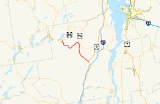
New York State Route 73 (NY 73) is a state highway
located entirely within Essex County, New York
, United States
. The highway begins at an intersection with NY 86
in the village of Lake Placid
and ends at a junction with U.S. Route 9 (US 9) north of the hamlet of Underwood in the extreme southwestern corner of the town of Elizabethtown
. NY 73 meanders through a mountainous region of Adirondack Park and passes by several named peaks, including Porter Mountain
and Lower Wolfjaw Mountain
. Along the way, the route has a short concurrency with NY 9N
in the town of Keene
.
In the early 19th century, Lake Placid and Keene were connected by the North West Bay Road, an east–west highway linking Hopkinton
to Westport
. The highway was initially a crude, impassable road; however, it was significantly improved by the state of New York in the mid-1810s. A highway linking Keene to Underwood was constructed by 1846; at Underwood, the road connected to a stagecoach road that went from Albany
to the Canadian border. The latter road became the basis for most of modern US 9.
NY 73 was assigned as part of the 1930 renumbering of state highways in New York from NY 28N
in Tahawus
to NY 22
in Ticonderoga
. The portion of the route from Tahawus to North Hudson
followed the Blue Ridge Road
; from North Hudson to Schroon
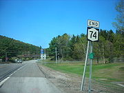
, NY 73 overlapped US 9. At the time, modern NY 73 was designated as New York State Route 86A from Lake Placid to Keene. By the following year, the remainder of current NY 73 had become New York State Route 427. NY 73 was cut back to Schroon ca. 1936 while NY 427 was replaced by an extended NY 86A ca. 1938. In the 1950s, NY 73 was extended northward to Lake Placid, supplanting NY 86A. The eastern terminus of NY 73 was moved to the vicinity of Underwood ca. 1973, and the former routing of NY 73 from Schroon to Ticonderoga became NY 74
.
. The highway heads towards the southwest, passing homes as Sentinel Road. At the intersection with Mill Pond Road, Route 73 passes a small pond, crossing over an associated creek. For that short time, the highway takes on a more southerly direction, mainly to the southeast. The surroundings of the highway remain the same as NY 73 leaves Lake Placid via Cascade Road.
 Route 73 heads into North Elba, where it passes Lake Placid Airport
. There, County Route 35 (CR 35) merges from the northwest, providing a bypass around the village of Lake Placid to NY 86. Just south of North Elba, Route 73 passes the Lake Placid Olympic Ski Jumping Complex
, accessible via NY 910M to nearby John Brown's Farm at the intersection with CR 35. The highway crosses the West Branch of the Ausable River, intersecting with CR 21 at an elevation of 1800 feet (548.6 m).
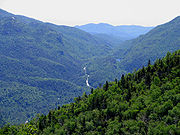
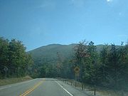
Cascade Road makes several turns, passing south of the Craig Wood Golf Course. After the golf course, Route 73 climbs in elevation, up to 2000 feet (609.6 m). The highway turns from the southeast to the east, and to the southeast once more as it rounds Round Lake. The road passes Mud Pond, where it turns to the northeast along the side of a high ridge. Pitchoff Mountain
is directly to the northwest as Route 73 passes Upper Cascade and Lower Cascade Lakes.
 Route 73 begins to descend in elevation, while CR 51 splits off and Route 73 heads into Keene
. After crossing the East Branch of the Ausable River, Route 73 merges in with NY 9N
. The two roads continue to drop in elevation, passing and circling mountains as they head along. After Norton Cemetery, Route 9N splits off to the east and Route 73 continues southward. Route 73 now runs along the East Branch, intersecting with county and local roads as it heads southward.
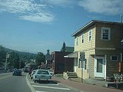
The highway heads along the base of Porter Mountain and into Keene Valley, crosses Johns Brook and heads through downtown. Lower Wolfjaw Mountain, which averages the same height as Porter, is nearby. Route 73 continues, eventually crossing the Ausable River branch. There are a few more ponds and mountains before NY 73 ends at an intersection with US 9.
According to estimates made by the New York State Department of Transportation
in 2009, NY 73 serves an average
of 1,950 vehicles from US 9 to the east end of the NY 9N overlap in Keene. The overlap with NY 9N accumulated an average of 4,360 vehicles, with the stretch up to the control station at NY 913Q having a less amount of traffic. After NY 913Q, the average increases, peaking at 4,810 vehicles per day at NY 86 in Lake Placid.
—the modern junction of NY 9N
and NY 73—was first settled in the first few years of the 19th century. Many of the early settlers arrived in the region by traveling along a rough and nearly unusable highway connecting what became Keene to Jay
in the north and Lewis
in the east. By 1810, part of the crude roadway had been supplanted by a privately funded highway leading westward from Westport
to at least North Elba
and possibly to Saranac Lake
by way of Keene. On April 5, 1810, the New York State Legislature passed an act establishing a new state highway linking Westport to Hopkinton
by way of Keene and Saranac Lake. The highway incorporated the entirety of the pre-existing roadway between Westport and Saranac Lake.
 Initially, the state highway was poorly constructed and largely impassable, mirroring the condition of the roadways that preceded it. An act passed by the state legislature on June 19, 1812, indicated that the funds that had been allocated to the highway were "entirely inadequate to open and improve" the road. On April 17, 1816, the state attempted to correct the issue by approving a measure that appointed two sets of commissioners to oversee the reconstruction of the highway. Each set was to work on opposite ends of the route and eventually converge at a point midway along the route. Work on the highway was completed by 1818. The road was officially named the "North West Bay Road"; however, it eventually became known as the "Old Military Road". The route did not enter the village of Lake Placid
; instead, it bypassed it to the southwest. This portion of the highway is still known today by the latter name.
to the Canadian border. The route fostered the rise of local lumber and tanning industries; up to 40 wagon loads of timber used the stagecoach route daily. Various hotels and taverns opened in the nearby town of North Hudson
to serve travelers along the route.
in Chester
became the northern half of Route 22, an unsigned legislative route
, under the text of the highway law. In 1913, the New York State Legislature created Route 22-b, a spur route
connecting Route 22 in Schroon
to the then-village of Ticonderoga. On March 1, 1921, Route 22-b became part of Route 48, a new route created as part of a partial renumbering of New York's legislative route system. The path of the former Albany–Canada stagecoach route was largely designated as US 9 in 1927.
 NY 73 was assigned as part of the 1930 renumbering of state highways in New York; however, it did not initially follow any of its modern routing. It began at an intersection with NY 28N
in Tahawus
and followed the Blue Ridge Road
east to US 9 in North Hudson. From there, it overlapped US 9 south to Schroon, where it proceeded eastward on the former legislative Route 48 to Ticonderoga, where it ended at a junction with NY 22
. At the time, modern NY 73 from Lake Placid to Keene—identical to the old North West Bay Road east of the Lake Placid area—was assigned NY 86A. The remainder of what is now NY 73 from Keene south to Underwood was designated as NY 427 within a year's time.
The portion of NY 73 between Tahawus and North Hudson
was removed from the state highway system ca. 1936. As a result, NY 73 was truncated to a new western terminus at US 9 in Schroon, eliminating the concurrency with US 9. To the north, NY 427 was supplanted by an extended NY 86A ca. 1938. In the early 1950s, NY 73 was extended eastward through Ticonderoga to the ferry dock on Lake Champlain
, where it connected to the Fort Ticonderoga – Larrabees Point Ferry. The change supplanted NY 347, a short spur route off NY 22 that had been in place since ca. 1934. In the mid-1950s, NY 73 was extended northward to Lake Placid via Underwood and Keene, replacing NY 86A and overlapping US 9 from Severance to Underwood. NY 73 was truncated to its current eastern terminus in Underwood ca. 1973, eliminating the 16 miles (26 km) overlap with US 9. Its former routing from Schroon to Lake Champlain was renumbered to NY 74
.
 On September 14, 1994, the state of New York signed a proposal to turn Route 73 into a scenic byway into law. The 30 miles (48 km) byway, known as the "High Peaks Scenic Byway", begins at the western terminus of NY 73 in Lake Placid and follows NY 73 and US 9 to Interstate 87 exit 30. In December 1994, the group Scenic America
designated the highway as one of the ten most scenic areas in the nation.
has made plans to repair seven bridges along NY 73. The seven projects will cost the state an estimated $11.1 million (2009 USD) and are tentatively scheduled to begin at various times between 2013 and 2016. The $11 million cost includes $4.3 million for two bridges over the West Branch of the Ausable River that were built in 1932, $1.3 million for a bridge over the Southern Fork of the Bouquet River
in Keene, $2.6 million for two bridges over Beede Brook that were built in 1935 and 1936, $1.3 million for a bridge over the outlet of Lower Cascade Lake, and $1.6 million for a bridge over Johns Brook.
State highway
State highway, state road or state route can refer to one of three related concepts, two of them related to a state or provincial government in a country that is divided into states or provinces :#A...
located entirely within Essex County, New York
Essex County, New York
Essex County is a county located in the U.S. state of New York. As of the 2010 census, the population was 39,370. Its name is from the English county of Essex. Its county seat is Elizabethtown...
, United States
United States
The United States of America is a federal constitutional republic comprising fifty states and a federal district...
. The highway begins at an intersection with NY 86
New York State Route 86
New York State Route 86 is a long state highway located within Adirondack Park in northern New York, United States, linking Franklin County to Essex County. The western terminus of the route is at NY 30 in the hamlet of Paul Smiths. The eastern terminus is at NY 9N in Jay...
in the village of Lake Placid
Lake Placid, New York
Lake Placid is a village in the Adirondack Mountains in Essex County, New York, United States. As of the 2000 census, the village had a population of 2,638....
and ends at a junction with U.S. Route 9 (US 9) north of the hamlet of Underwood in the extreme southwestern corner of the town of Elizabethtown
Elizabethtown, New York
Elizabethtown is a town in Essex County, New York, United States. The population was 1,315 at the 2000 census. The county seat of Essex County is a hamlet also called Elizabethtown. The name is derived from Elizabeth Gilliland, the wife of an early settler....
. NY 73 meanders through a mountainous region of Adirondack Park and passes by several named peaks, including Porter Mountain
Porter Mountain
Porter Mountain is in Essex County of New York. It is one of the 46 Adirondack High Peaks and is located in the Adirondack Park. Its name comes from Noah Porter, later president of Yale University and one of the first to climb it....
and Lower Wolfjaw Mountain
Lower Wolfjaw Mountain
Lower Wolfjaw Mountain is located in Essex County, New York. Landscape artist Alexander Helwig Wyant named Lower Wolfjaw, together with neighboring Upper Wolfjaw Mountain, about 1870 for their appearance in profile. The mountain is the northeasternmost of the Adirondack High Peaks in the Great...
. Along the way, the route has a short concurrency with NY 9N
New York State Route 9N
New York State Route 9N is a north–south state highway in northeastern New York, United States. It extends from an intersection with U.S. Route 9 , NY 29, and NY 50 in the city of Saratoga Springs to a junction with US 9 and NY 22 in the Clinton County village of...
in the town of Keene
Keene, New York
Keene is a town in central Essex County, New York, United States. The population was 1,063 at the 2000 census. Keene is the home of Mount Marcy, the highest mountain in New York state, as well as the Great Range and 15 of the 46 High Peaks, and the Ausable Lakes, the source of the Ausable River...
.
In the early 19th century, Lake Placid and Keene were connected by the North West Bay Road, an east–west highway linking Hopkinton
Hopkinton, New York
Hopkinton is a town in St. Lawrence County, New York in the United States. The population was 1,020 at the 2000 census. The name is derived from early settlers with the name Hopkins....
to Westport
Westport, New York
Westport is a town in Essex County, New York, United States overlooking Lake Champlain. The population was 1,362 at the 2000 census.The Town of Westport is on the eastern border of the county and is south of Plattsburgh and south of Montreal. Westport is inside the Adirondack Park.Westport is...
. The highway was initially a crude, impassable road; however, it was significantly improved by the state of New York in the mid-1810s. A highway linking Keene to Underwood was constructed by 1846; at Underwood, the road connected to a stagecoach road that went from Albany
Albany, New York
Albany is the capital city of the U.S. state of New York, the seat of Albany County, and the central city of New York's Capital District. Roughly north of New York City, Albany sits on the west bank of the Hudson River, about south of its confluence with the Mohawk River...
to the Canadian border. The latter road became the basis for most of modern US 9.
NY 73 was assigned as part of the 1930 renumbering of state highways in New York from NY 28N
New York State Route 28N
New York State Route 28N is a state highway in the Adirondacks in New York that extends from Blue Mountain Lake to North Creek. The route, in length, is a northerly alternate route to NY 28 between both locations. The highway passes through several communities before terminating at...
in Tahawus
Tahawus, New York
Tahawus was a village in the Town of Newcomb, Essex County, New York, USA. It is now a ghost town situated in Adirondack Park. Tahawus is located in Essex County within the unpopulated northern area designated to the town of Newcomb. Tahawus was the site of major mining and iron smelting...
to NY 22
New York State Route 22
New York State Route 22 is a north–south state highway in eastern New York in the United States. It runs parallel to the state's eastern edge from the outskirts of New York City to a short distance south of the Canadian border. At , it is the state's longest north–south route and...
in Ticonderoga
Ticonderoga, New York
Ticonderoga is a town in Essex County, New York, USA. The population was 5,167 at the 2000 census. The name comes from the Mohawk tekontaró:ken, meaning "it is at the junction of two waterways"....
. The portion of the route from Tahawus to North Hudson
North Hudson, New York
North Hudson is a town in Essex County, New York, United States. The population was 266 at the 2000 census. The town derives its name by being by the north end of the Hudson River....
followed the Blue Ridge Road
Blue Ridge Road
Blue Ridge Road is a long roadway in Essex County, New York, in the United States. The road is designated as County Route 84 from NY 28N in Newcomb to Interstate 87 in North Hudson, and as New York State Route 910K between I-87 and U.S. Route 9 in North Hudson...
; from North Hudson to Schroon
Schroon, New York
Schroon is a town in the Adirondack Park, in Essex County, New York, United States. The population was 1,759 at the 2000 census. The town is also known as Schroon Lake, which is actually a centrally located lake, and the name of a hamlet on the lake....
, NY 73 overlapped US 9. At the time, modern NY 73 was designated as New York State Route 86A from Lake Placid to Keene. By the following year, the remainder of current NY 73 had become New York State Route 427. NY 73 was cut back to Schroon ca. 1936 while NY 427 was replaced by an extended NY 86A ca. 1938. In the 1950s, NY 73 was extended northward to Lake Placid, supplanting NY 86A. The eastern terminus of NY 73 was moved to the vicinity of Underwood ca. 1973, and the former routing of NY 73 from Schroon to Ticonderoga became NY 74
New York State Route 74
New York State Route 74 and Vermont Route 74 are adjoining state highways in the northeastern United States, connected by one of the last remaining cable ferries in North America. Together they extend for through Essex County, New York, and Addison County, Vermont...
.
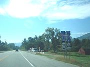
Lake Placid to Lower Cascade Lake
Route 73 begins at a traffic light along NY 86 near the eastern end of the village of Lake PlacidLake Placid, New York
Lake Placid is a village in the Adirondack Mountains in Essex County, New York, United States. As of the 2000 census, the village had a population of 2,638....
. The highway heads towards the southwest, passing homes as Sentinel Road. At the intersection with Mill Pond Road, Route 73 passes a small pond, crossing over an associated creek. For that short time, the highway takes on a more southerly direction, mainly to the southeast. The surroundings of the highway remain the same as NY 73 leaves Lake Placid via Cascade Road.
Lake Placid Airport
Lake Placid Airport is a public use airport located one nautical mile southeast of the central business district of Lake Placid, a village in the Town of North Elba, Essex County, New York, United States...
. There, County Route 35 (CR 35) merges from the northwest, providing a bypass around the village of Lake Placid to NY 86. Just south of North Elba, Route 73 passes the Lake Placid Olympic Ski Jumping Complex
Lake Placid Olympic Ski Jumping Complex
The Lake Placid Olympic Ski Jumping Complex comprises a 90- and 120-meter ski jumps towers built for the 1980 Olympic Games in Lake Placid, New York, United States...
, accessible via NY 910M to nearby John Brown's Farm at the intersection with CR 35. The highway crosses the West Branch of the Ausable River, intersecting with CR 21 at an elevation of 1800 feet (548.6 m).
Cascade Road makes several turns, passing south of the Craig Wood Golf Course. After the golf course, Route 73 climbs in elevation, up to 2000 feet (609.6 m). The highway turns from the southeast to the east, and to the southeast once more as it rounds Round Lake. The road passes Mud Pond, where it turns to the northeast along the side of a high ridge. Pitchoff Mountain
Pitchoff Mountain
Pitchoff Mountain is a mountain opposite Cascade Mountain on NY 73 west of Keene Valley in Essex County, New York, in the US. There are two summits; the higher summit is viewless, but the northern summit, at offers 360 degree views of the nearby Cascade Lakes, the High Peaks of the Adirondacks,...
is directly to the northwest as Route 73 passes Upper Cascade and Lower Cascade Lakes.
Cascades Lakes to Underwood
Keene, New York
Keene is a town in central Essex County, New York, United States. The population was 1,063 at the 2000 census. Keene is the home of Mount Marcy, the highest mountain in New York state, as well as the Great Range and 15 of the 46 High Peaks, and the Ausable Lakes, the source of the Ausable River...
. After crossing the East Branch of the Ausable River, Route 73 merges in with NY 9N
New York State Route 9N
New York State Route 9N is a north–south state highway in northeastern New York, United States. It extends from an intersection with U.S. Route 9 , NY 29, and NY 50 in the city of Saratoga Springs to a junction with US 9 and NY 22 in the Clinton County village of...
. The two roads continue to drop in elevation, passing and circling mountains as they head along. After Norton Cemetery, Route 9N splits off to the east and Route 73 continues southward. Route 73 now runs along the East Branch, intersecting with county and local roads as it heads southward.
The highway heads along the base of Porter Mountain and into Keene Valley, crosses Johns Brook and heads through downtown. Lower Wolfjaw Mountain, which averages the same height as Porter, is nearby. Route 73 continues, eventually crossing the Ausable River branch. There are a few more ponds and mountains before NY 73 ends at an intersection with US 9.
According to estimates made by the New York State Department of Transportation
New York State Department of Transportation
The New York State Department of Transportation is responsible for the development and operation of highways, railroads, mass transit systems, ports, waterways and aviation facilities in the U.S...
in 2009, NY 73 serves an average
Annual average daily traffic
Average Annual daily traffic, abbreviated AADT, is a measure used primarily in transportation planning and transportation engineering. It is the total volume of vehicle traffic of a highway or road for a year divided by 365 days. AADT is a useful and simple measurement of how busy the road is...
of 1,950 vehicles from US 9 to the east end of the NY 9N overlap in Keene. The overlap with NY 9N accumulated an average of 4,360 vehicles, with the stretch up to the control station at NY 913Q having a less amount of traffic. After NY 913Q, the average increases, peaking at 4,810 vehicles per day at NY 86 in Lake Placid.
North West Bay Road
The area that is now known as the hamlet of KeeneKeene, New York
Keene is a town in central Essex County, New York, United States. The population was 1,063 at the 2000 census. Keene is the home of Mount Marcy, the highest mountain in New York state, as well as the Great Range and 15 of the 46 High Peaks, and the Ausable Lakes, the source of the Ausable River...
—the modern junction of NY 9N
New York State Route 9N
New York State Route 9N is a north–south state highway in northeastern New York, United States. It extends from an intersection with U.S. Route 9 , NY 29, and NY 50 in the city of Saratoga Springs to a junction with US 9 and NY 22 in the Clinton County village of...
and NY 73—was first settled in the first few years of the 19th century. Many of the early settlers arrived in the region by traveling along a rough and nearly unusable highway connecting what became Keene to Jay
Jay, New York
Jay is a town in Essex County, New York, United States. The population was 2,306 at the 2000 census. The town is named after John Jay, governor of New York when the town was formed....
in the north and Lewis
Lewis, Essex County, New York
----Lewis is a town in Essex County, New York, United States. The population was 1,200 at the 2000 census. The town is named after Morgan Lewis, the governor of New York at the time the town was established....
in the east. By 1810, part of the crude roadway had been supplanted by a privately funded highway leading westward from Westport
Westport, New York
Westport is a town in Essex County, New York, United States overlooking Lake Champlain. The population was 1,362 at the 2000 census.The Town of Westport is on the eastern border of the county and is south of Plattsburgh and south of Montreal. Westport is inside the Adirondack Park.Westport is...
to at least North Elba
North Elba, New York
North Elba is a town in Essex County, New York, United States. The population was 8,661 at the 2000 census. The town is named after the island of Elba.North Elba is on the western edge of the county...
and possibly to Saranac Lake
Saranac Lake, New York
Saranac Lake is a village located in the state of New York, United States. As of the 2010 census, the population was 5,406. The village is named after Upper, Middle, and Lower Saranac Lakes, which are nearby....
by way of Keene. On April 5, 1810, the New York State Legislature passed an act establishing a new state highway linking Westport to Hopkinton
Hopkinton, New York
Hopkinton is a town in St. Lawrence County, New York in the United States. The population was 1,020 at the 2000 census. The name is derived from early settlers with the name Hopkins....
by way of Keene and Saranac Lake. The highway incorporated the entirety of the pre-existing roadway between Westport and Saranac Lake.
Lake Placid, New York
Lake Placid is a village in the Adirondack Mountains in Essex County, New York, United States. As of the 2000 census, the village had a population of 2,638....
; instead, it bypassed it to the southwest. This portion of the highway is still known today by the latter name.
Other highways
The highway through Keene Valley from Underwood to Keene was built by 1846. At its southern end, it connected to a major stagecoach road that connected AlbanyAlbany, New York
Albany is the capital city of the U.S. state of New York, the seat of Albany County, and the central city of New York's Capital District. Roughly north of New York City, Albany sits on the west bank of the Hudson River, about south of its confluence with the Mohawk River...
to the Canadian border. The route fostered the rise of local lumber and tanning industries; up to 40 wagon loads of timber used the stagecoach route daily. Various hotels and taverns opened in the nearby town of North Hudson
North Hudson, New York
North Hudson is a town in Essex County, New York, United States. The population was 266 at the 2000 census. The town derives its name by being by the north end of the Hudson River....
to serve travelers along the route.
State ownership and designations
In 1909, the state of New York began to take control of many private highways across the state under the terms of the new highway law developed in 1908. One of these highways was the old north–south stagecoach road from Albany to Canada. Most of the highway north of modern NY 8New York State Route 8
New York State Route 8 is a state highway in the central part of New York in the United States. It runs in a southwest-to-northeast direction from the Southern Tier to the northern part of Lake George. The southern terminus of the route is at an interchange with NY 17 in the town of...
in Chester
Chester, Warren County, New York
----Chester is a town in Warren County, New York, United States. It is part of the Glens Falls Metropolitan Statistical Area. The population was 3,614 at the 2000 census...
became the northern half of Route 22, an unsigned legislative route
Legislative route
In United States, a legislative route or legislative highway is a highway defined by laws passed in a state legislature. The numbering of such highways may or may not correspond to the numbers familiar to the public as part of the state, U.S. highway, and Interstate highway systems...
, under the text of the highway law. In 1913, the New York State Legislature created Route 22-b, a spur route
Spur route
A spur route is a short road forming a branch from a longer, more important route . A bypass or beltway is never considered a true spur route as it typically reconnects with the major road...
connecting Route 22 in Schroon
Schroon, New York
Schroon is a town in the Adirondack Park, in Essex County, New York, United States. The population was 1,759 at the 2000 census. The town is also known as Schroon Lake, which is actually a centrally located lake, and the name of a hamlet on the lake....
to the then-village of Ticonderoga. On March 1, 1921, Route 22-b became part of Route 48, a new route created as part of a partial renumbering of New York's legislative route system. The path of the former Albany–Canada stagecoach route was largely designated as US 9 in 1927.
New York State Route 28N
New York State Route 28N is a state highway in the Adirondacks in New York that extends from Blue Mountain Lake to North Creek. The route, in length, is a northerly alternate route to NY 28 between both locations. The highway passes through several communities before terminating at...
in Tahawus
Tahawus, New York
Tahawus was a village in the Town of Newcomb, Essex County, New York, USA. It is now a ghost town situated in Adirondack Park. Tahawus is located in Essex County within the unpopulated northern area designated to the town of Newcomb. Tahawus was the site of major mining and iron smelting...
and followed the Blue Ridge Road
Blue Ridge Road
Blue Ridge Road is a long roadway in Essex County, New York, in the United States. The road is designated as County Route 84 from NY 28N in Newcomb to Interstate 87 in North Hudson, and as New York State Route 910K between I-87 and U.S. Route 9 in North Hudson...
east to US 9 in North Hudson. From there, it overlapped US 9 south to Schroon, where it proceeded eastward on the former legislative Route 48 to Ticonderoga, where it ended at a junction with NY 22
New York State Route 22
New York State Route 22 is a north–south state highway in eastern New York in the United States. It runs parallel to the state's eastern edge from the outskirts of New York City to a short distance south of the Canadian border. At , it is the state's longest north–south route and...
. At the time, modern NY 73 from Lake Placid to Keene—identical to the old North West Bay Road east of the Lake Placid area—was assigned NY 86A. The remainder of what is now NY 73 from Keene south to Underwood was designated as NY 427 within a year's time.
The portion of NY 73 between Tahawus and North Hudson
North Hudson, New York
North Hudson is a town in Essex County, New York, United States. The population was 266 at the 2000 census. The town derives its name by being by the north end of the Hudson River....
was removed from the state highway system ca. 1936. As a result, NY 73 was truncated to a new western terminus at US 9 in Schroon, eliminating the concurrency with US 9. To the north, NY 427 was supplanted by an extended NY 86A ca. 1938. In the early 1950s, NY 73 was extended eastward through Ticonderoga to the ferry dock on Lake Champlain
Lake Champlain
Lake Champlain is a natural, freshwater lake in North America, located mainly within the borders of the United States but partially situated across the Canada—United States border in the Canadian province of Quebec.The New York portion of the Champlain Valley includes the eastern portions of...
, where it connected to the Fort Ticonderoga – Larrabees Point Ferry. The change supplanted NY 347, a short spur route off NY 22 that had been in place since ca. 1934. In the mid-1950s, NY 73 was extended northward to Lake Placid via Underwood and Keene, replacing NY 86A and overlapping US 9 from Severance to Underwood. NY 73 was truncated to its current eastern terminus in Underwood ca. 1973, eliminating the 16 miles (26 km) overlap with US 9. Its former routing from Schroon to Lake Champlain was renumbered to NY 74
New York State Route 74
New York State Route 74 and Vermont Route 74 are adjoining state highways in the northeastern United States, connected by one of the last remaining cable ferries in North America. Together they extend for through Essex County, New York, and Addison County, Vermont...
.
Scenic America
Scenic America is a nonprofit advocacy organization and the only national group solely dedicated to removing visual blight and preserving and enhancing the scenic character of America's communities and countryside.-Scenic America's mission:...
designated the highway as one of the ten most scenic areas in the nation.
Future
The New York State Department of TransportationNew York State Department of Transportation
The New York State Department of Transportation is responsible for the development and operation of highways, railroads, mass transit systems, ports, waterways and aviation facilities in the U.S...
has made plans to repair seven bridges along NY 73. The seven projects will cost the state an estimated $11.1 million (2009 USD) and are tentatively scheduled to begin at various times between 2013 and 2016. The $11 million cost includes $4.3 million for two bridges over the West Branch of the Ausable River that were built in 1932, $1.3 million for a bridge over the Southern Fork of the Bouquet River
Bouquet River
The Boquet River is a small river in upstate New York, USA. The river flows into Lake Champlain at the east border of the Town of Willsboro in Essex County....
in Keene, $2.6 million for two bridges over Beede Brook that were built in 1935 and 1936, $1.3 million for a bridge over the outlet of Lower Cascade Lake, and $1.6 million for a bridge over Johns Brook.
Major intersections
See also
- List of state highways in Essex County, New York
- New York State Route 97 – another state highway that is entirely a scenic byway