
New York State Route 146
Encyclopedia
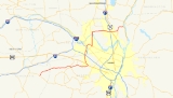
New York State Route 146 (NY 146) is a state highway
in the Capital District of New York
in the United States
. It extends for 43 miles (69 km) from Gallupville at NY 443
to near Mechanicville
at U.S. Route 4
(US 4) and NY 32
. NY 146 is a major thoroughfare in the city of Schenectady
, just outside of Albany
. Most of the route follows an east–west alignment; however, the middle third of the route between Guilderland
and Clifton Park
runs in a more north–south manner in order to serve Schenectady. At one time, NY 146 had three spur routes; only one—NY 146A
—still exists.
NY 146 was assigned as part of the 1930 renumbering of state highways in New York. At the time, NY 146 began at modern NY 443 in Berne
and followed what is now NY 156
northeast to Altamont while modern NY 146 west of Altamont was part of NY 156. The alignments of the two routes were flipped in the late 1930s. Other minor realignments have occurred since, most notably near Mechanicville.
in Gallupville, a hamlet within the town of Wright
. The highway spends only 4.24 miles (6.82 km) in Schoharie County
before passing into neighboring Albany County
. Along this stretch, NY 143 has an intersection with County Route 26 (CR 26, named Larry Hill Road) just over 1 miles (1.6 km) from NY 443. After crossing into Albany County, NY 146 turns eastward and heads toward Albany
, the capital of New York
. In the Knox
hamlet of West, NY 146 intersects CR 259. As NY 146 reaches the hamlet of East a short time later, it meets CRs 252, 260, 261, and 262 in quick succession. NY 146 continues eastward, passing through a rural area of Albany County on its way to the town of Guilderland
and the village of Altamont contained within.
NY 146 enters Altamont from the west on Western Avenue. At Maple Avenue, NY 146 turns south to follow that street for two blocks while NY 397
begins on the road that NY 146 vacates. NY 146 leaves Maple Avenue at Main Street—the latter of which connects to NY 156
one block to the west—and follows Main Street eastward out of the village. After leaving Altamont, NY 146 continues for about 3 miles (5 km) through a lightly populated portion of Guilderland before intersecting with the southern terminus of NY 158
. The route progresses onward, intersecting CRs 201 and 202 and passing over the CSX Transportation
-owned Selkirk Subdivision
railroad line and Normans Kill before meeting US 20 at Hartmans Corners. NY 146 joins US 20 for about 0.7 miles (1.1 km) northwestward to McCormack Corners, where NY 146 leaves US 20 and heads northward toward Schenectady County
. The route passes over the New York State Thruway
(Interstate 90 or I-90) just south of the county line.
. NY 146 continues on through Rotterdam
, meeting NY 7
at a junction about 2 miles (3.2 km) south of Schenectady
. The route continues on, paralleling I-890 into the Schenectady city limits at Glengary Avenue. Here, maintenance of the route shifts from the New York State Department of Transportation
(NYSDOT) to the city of Schenectady. Five blocks later, NY 146 intersects with Altamont Avenue (unsigned NY 911H) just before crossing over I-890 and entering Schenectady's downtown district. In downtown Schenectady, NY 146 follows Brandywine Avenue northeastward past an intersection with NY 5
(State Street) to Union Street, where the route turns to follow Union eastward out of the city. Upon crossing into Niskayuna, ownership of the route shifts to Schenectady County, which maintains the roadway as CR 159. CR 159 ends five blocks later at Balltown Road (unsigned NY 914T
). NY 146 turns north onto Balltown, becoming NYSDOT maintained once more in the process.
3.5 miles (5.6 km) north of Union Street, NY 146 crosses over the Mohawk River
and enters Saratoga County
. On the north bank of the river in Clifton Park
, CRs 88 and 91 terminate at NY 146 in opposite directions. This portion of CR 91 was once part of NY 146B, a former spur of NY 146. NY 146 turns eastward three-quarters of a mile (1.2 km) later at a junction with Glenridge Road (unsigned NY 914V) and CR 110. Just outside of Clifton Park Center, NY 146 meets NY 146A
, the lone remaining spur of NY 146. Soon after the NY 146A intersection, the route encounters I-87
(the Adirondack Northway) at exit 9 and intersects US 9. About 2 miles (3.2 km) east of US 9 in Halfmoon
, NY 236
merges in from the south. NY 146 veers northward at this junction, then breaks eastward a mile (1.6 km) later at an intersection with CR 1345 southwest of Mechanicville
. NY 146 comes to an end soon afterward at US 4
and NY 32
south of Mechanicville on the banks of the Hudson River
.
(now NY 443
) in Berne
northeast through Schenectady
to US 4
and NY 32
in Mechanicville
. The portion of the route northeast of Altamont generally followed its modern alignment; however, west of Altamont, NY 146 followed what is now NY 156
. At the time, the portion of modern NY 146 west of Altamont was part of NY 156. The alignments of NY 146 and NY 156 west of Altamont were flipped ca. 1940. Although most of former NY 146 west of Altamont became part of NY 156, a one-block section of Main Street within the village did not and is now designated as NY 912C, an unsigned reference route. The 0.08 mile (0.1287472 km) route serves as a connector between NY 156 and NY 146, which do not meet despite both highways using Main Street as an entrance to the village. Both NY 156 and NY 146 are marked with signs directing traffic to the other route by way of this one block of Main Street.
In Schenectady, NY 146 was originally routed on Union, Jay, and Nott Streets and Van Vranken Avenue through the northern portion of the city. It was realigned between 1938 and 1947 to bypass the northern part of the city on Balltown Road. The New York State Department of Transportation
(NYSDOT) has reserved the NY 646 designation for the former routing of NY 146 through Schenectady; however, there is no timetable for its assignment. In Halfmoon
, NY 146 was initially routed on Pruyn Hill Road and South Street in the vicinity of Mechanicville
. The route was altered in the late 1940s to follow a new highway that bypassed Mechanicville to the south. The portion of NY 146's former routing outside of the Mechanicville city limits is now designated and signed as CR 1345, reflecting the number of the legislative state highway (SH 1345) that makes up the portion of NY 146 in Halfmoon and thus once followed Pruyn Hill Road. CR 1345 is the only signed four-digit county route in New York
.
(NYSDOT) has identified the NY 146 corridor from Riverview Road to Glen Ridge Road as in need of future improvements. Intersection improvements are scheduled at the NY 146 / Aqueduct Road / Williams Road and NY 146 / Riverview Road intersections. This part of the project will be built in 2008 and is to include new turn lanes at each intersection. To the south, the Rexford Bridge over the Mohawk River
and the surrounding roadway will be improved in stages, with completion expected by 2017. The objective of these projects is to improve highway capacity and safety along the corridor.
State highway
State highway, state road or state route can refer to one of three related concepts, two of them related to a state or provincial government in a country that is divided into states or provinces :#A...
in the Capital District of New York
New York
New York is a state in the Northeastern region of the United States. It is the nation's third most populous state. New York is bordered by New Jersey and Pennsylvania to the south, and by Connecticut, Massachusetts and Vermont to the east...
in the United States
United States
The United States of America is a federal constitutional republic comprising fifty states and a federal district...
. It extends for 43 miles (69 km) from Gallupville at NY 443
New York State Route 443
New York State Route 443 is an east–west state highway in the Capital District of New York in the United States. The route begins at an intersection with NY 30 in the town of Schoharie and ends later at a junction with U.S. Route 9W and US 20 in the city of Albany...
to near Mechanicville
Mechanicville, New York
Mechanicville is a city in Saratoga County, New York, United States. The population is 5,196 as of the 2010 census. It is the smallest city by area in the state. The name is derived from the occupations of early residents....
at U.S. Route 4
U.S. Route 4 in New York
U.S. Route 4 is a part of the U.S. Highway System that runs from East Greenbush, New York, to Portsmouth, New Hampshire. In the U.S. state of New York, US 4 extends from an intersection with US 9 and US 20 in East Greenbush to the Vermont state line northeast of Whitehall...
(US 4) and NY 32
New York State Route 32
New York State Route 32 is a north–south state highway that extends for through the Hudson Valley and Capital District regions of the U.S. state of New York. It is a two-lane surface road for nearly its entire length, with few divided and no limited-access sections. From Harriman to Albany,...
. NY 146 is a major thoroughfare in the city of Schenectady
Schenectady, New York
Schenectady is a city in Schenectady County, New York, United States, of which it is the county seat. As of the 2010 census, the city had a population of 66,135...
, just outside of Albany
Albany, New York
Albany is the capital city of the U.S. state of New York, the seat of Albany County, and the central city of New York's Capital District. Roughly north of New York City, Albany sits on the west bank of the Hudson River, about south of its confluence with the Mohawk River...
. Most of the route follows an east–west alignment; however, the middle third of the route between Guilderland
Guilderland, New York
Guilderland is a town in Albany County, New York, United States. In the 2010 census, the town had a population of 35,303. The town is named for the Gelderland province in the Netherlands....
and Clifton Park
Clifton Park, New York
Clifton Park is a town in Saratoga County, New York, United States. According to the United States Census Bureau, the 2009 population estimate for Clifton Park was 36,469. The name is derived from an early land patent...
runs in a more north–south manner in order to serve Schenectady. At one time, NY 146 had three spur routes; only one—NY 146A
New York State Route 146A
New York State Route 146A is a state highway in New York State. It begins at NY 146 in Clifton Park and ends at NY 50 in Ballston Lake. It is located entirely within Saratoga County...
—still exists.
NY 146 was assigned as part of the 1930 renumbering of state highways in New York. At the time, NY 146 began at modern NY 443 in Berne
Berne, New York
Berne is a town in Albany County, New York, United States. The population was 2,794 at the 2010 census. The town is at the west border of Albany County.- History :...
and followed what is now NY 156
New York State Route 156
New York State Route 156 is a state highway in New York. The highway runs from the hamlet of Berne to the village of Voorheesville. A two-lane highway its entire length, NY 156 is entirely located within Albany County....
northeast to Altamont while modern NY 146 west of Altamont was part of NY 156. The alignments of the two routes were flipped in the late 1930s. Other minor realignments have occurred since, most notably near Mechanicville.
Route description
Schoharie and Albany Counties
NY 146 begins at a T-intersection with NY 443New York State Route 443
New York State Route 443 is an east–west state highway in the Capital District of New York in the United States. The route begins at an intersection with NY 30 in the town of Schoharie and ends later at a junction with U.S. Route 9W and US 20 in the city of Albany...
in Gallupville, a hamlet within the town of Wright
Wright, New York
Wright is a town in Schoharie County, New York, United States. The population was 1,547 at the 2000 census. The town was named after governor Silas Wright.The Town of Wright is on the county's northeastern corner and is west of Albany.- History :...
. The highway spends only 4.24 miles (6.82 km) in Schoharie County
Schoharie County, New York
As of the census of 2000, there were 31,582 people, 11,991 households and 8,177 families residing in the county. The population density was 51 people per square mile . There were 15,915 housing units at an average density of 26 per square mile...
before passing into neighboring Albany County
Albany County, New York
Albany County is a county located in the U.S. state of New York, and is part of the Albany-Schenectady-Troy Metropolitan Statistical Area. The name is from the title of the Duke of York and Albany, who became James II of England . As of the 2010 census, the population was 304,204...
. Along this stretch, NY 143 has an intersection with County Route 26 (CR 26, named Larry Hill Road) just over 1 miles (1.6 km) from NY 443. After crossing into Albany County, NY 146 turns eastward and heads toward Albany
Albany, New York
Albany is the capital city of the U.S. state of New York, the seat of Albany County, and the central city of New York's Capital District. Roughly north of New York City, Albany sits on the west bank of the Hudson River, about south of its confluence with the Mohawk River...
, the capital of New York
New York
New York is a state in the Northeastern region of the United States. It is the nation's third most populous state. New York is bordered by New Jersey and Pennsylvania to the south, and by Connecticut, Massachusetts and Vermont to the east...
. In the Knox
Knox, New York
Knox is a town in Albany County, New York, United States. The population was 2,692 at the 2010 census.The Town is in the northwest part of Albany County and is west of Albany, the state capital.- History :...
hamlet of West, NY 146 intersects CR 259. As NY 146 reaches the hamlet of East a short time later, it meets CRs 252, 260, 261, and 262 in quick succession. NY 146 continues eastward, passing through a rural area of Albany County on its way to the town of Guilderland
Guilderland, New York
Guilderland is a town in Albany County, New York, United States. In the 2010 census, the town had a population of 35,303. The town is named for the Gelderland province in the Netherlands....
and the village of Altamont contained within.
NY 146 enters Altamont from the west on Western Avenue. At Maple Avenue, NY 146 turns south to follow that street for two blocks while NY 397
New York State Route 397
New York State Route 397 is a short state highway in New York, running from the village of Altamont to the hamlet of Dunnsville within the town of Guilderland, in Albany County. NY 397 is a two-lane highway its entire length....
begins on the road that NY 146 vacates. NY 146 leaves Maple Avenue at Main Street—the latter of which connects to NY 156
New York State Route 156
New York State Route 156 is a state highway in New York. The highway runs from the hamlet of Berne to the village of Voorheesville. A two-lane highway its entire length, NY 156 is entirely located within Albany County....
one block to the west—and follows Main Street eastward out of the village. After leaving Altamont, NY 146 continues for about 3 miles (5 km) through a lightly populated portion of Guilderland before intersecting with the southern terminus of NY 158
New York State Route 158
New York State Route 158 is a state highway in New York, running from near the Albany County village of Altamont to the Schenectady County town of Rotterdam, just outside Schenectady...
. The route progresses onward, intersecting CRs 201 and 202 and passing over the CSX Transportation
CSX Transportation
CSX Transportation operates a Class I railroad in the United States known as the CSX Railroad. It is the main subsidiary of the CSX Corporation. The company is headquartered in Jacksonville, Florida, and owns approximately 21,000 route miles...
-owned Selkirk Subdivision
Selkirk Subdivision
The Selkirk Subdivision is a railroad line owned by CSX Transportation in the U.S. State of New York. The line runs from Selkirk northwest to Amsterdam along a former New York Central Railroad line. At its southeast end, at Selkirk Yard, the Selkirk Subdivision becomes the Castleton Subdivision...
railroad line and Normans Kill before meeting US 20 at Hartmans Corners. NY 146 joins US 20 for about 0.7 miles (1.1 km) northwestward to McCormack Corners, where NY 146 leaves US 20 and heads northward toward Schenectady County
Schenectady County, New York
Schenectady County is a county located in the U.S. state of New York. As of the 2010 census, the population was 154,727. It is part of the Albany-Schenectady-Troy Metropolitan Statistical Area. The county seat is Schenectady. The name is from a Mohawk Indian word meaning "on the other side of the...
. The route passes over the New York State Thruway
New York State Thruway
The New York State Thruway is a system of limited-access highways located within the state of New York in the United States. The system, known officially as the Governor Thomas E. Dewey Thruway for former New York Governor Thomas E. Dewey, is operated by the New York State Thruway Authority and...
(Interstate 90 or I-90) just south of the county line.
Schenectady and Saratoga Counties
At the county line, Fort Hunter Road (CR 71) leaves to the left just before an interchange with I-890Interstate 890
Interstate 890 is a long auxiliary Interstate Highway in the vicinity of Schenectady, New York, United States. The highway runs southeast–northwest from an interchange with the New York State Thruway northwest of Schenectady to another junction with the Thruway south of the city and passes...
. NY 146 continues on through Rotterdam
Rotterdam (town), New York
Rotterdam is a town in Schenectady County, New York, United States. The population was 28,316 at the 2000 census.The town of Rotterdam is in the south-central part of the county. It was founded by Dutch settlers, who named it after the port of Rotterdam in the Netherlands, where many emigrants last...
, meeting NY 7
New York State Route 7
New York State Route 7 is a 180-mile long New York State Highway that runs from the New York/Pennsylvania border south of Binghamton, New York to the New York/Vermont border east of Hoosick. Most of the road runs along the Susquehanna Valley, closely paralleling Interstate 88 throughout...
at a junction about 2 miles (3.2 km) south of Schenectady
Schenectady, New York
Schenectady is a city in Schenectady County, New York, United States, of which it is the county seat. As of the 2010 census, the city had a population of 66,135...
. The route continues on, paralleling I-890 into the Schenectady city limits at Glengary Avenue. Here, maintenance of the route shifts from the New York State Department of Transportation
New York State Department of Transportation
The New York State Department of Transportation is responsible for the development and operation of highways, railroads, mass transit systems, ports, waterways and aviation facilities in the U.S...
(NYSDOT) to the city of Schenectady. Five blocks later, NY 146 intersects with Altamont Avenue (unsigned NY 911H) just before crossing over I-890 and entering Schenectady's downtown district. In downtown Schenectady, NY 146 follows Brandywine Avenue northeastward past an intersection with NY 5
New York State Route 5
New York State Route 5 is a state highway that extends for across the state of New York in the United States. It begins at the Pennsylvania state line in the Chautauqua County town of Ripley and passes through Buffalo, Syracuse, Utica, Schenectady, and several other smaller cities and...
(State Street) to Union Street, where the route turns to follow Union eastward out of the city. Upon crossing into Niskayuna, ownership of the route shifts to Schenectady County, which maintains the roadway as CR 159. CR 159 ends five blocks later at Balltown Road (unsigned NY 914T
New York State Route 914T
New York State Route 914T is an unsigned reference route designation for the portion of Balltown Road south of Union Street in Schenectady, New York. The route is a short two-lane highway just east of the city limits, running from NY 5 to its intersection with Union Street where...
). NY 146 turns north onto Balltown, becoming NYSDOT maintained once more in the process.
3.5 miles (5.6 km) north of Union Street, NY 146 crosses over the Mohawk River
Mohawk River
The Mohawk River is a river in the U.S. state of New York. It is the largest tributary of the Hudson River. The Mohawk flows into the Hudson in the Capital District, a few miles north of the city of Albany. The river is named for the Mohawk Nation of the Iroquois Confederacy...
and enters Saratoga County
Saratoga County, New York
Saratoga County is a county located in the U.S. state of New York. As of the 2010 census, the population was 219,607. It is part of the Albany-Schenectady-Troy Metropolitan Statistical Area. The county seat is Ballston Spa...
. On the north bank of the river in Clifton Park
Clifton Park, New York
Clifton Park is a town in Saratoga County, New York, United States. According to the United States Census Bureau, the 2009 population estimate for Clifton Park was 36,469. The name is derived from an early land patent...
, CRs 88 and 91 terminate at NY 146 in opposite directions. This portion of CR 91 was once part of NY 146B, a former spur of NY 146. NY 146 turns eastward three-quarters of a mile (1.2 km) later at a junction with Glenridge Road (unsigned NY 914V) and CR 110. Just outside of Clifton Park Center, NY 146 meets NY 146A
New York State Route 146A
New York State Route 146A is a state highway in New York State. It begins at NY 146 in Clifton Park and ends at NY 50 in Ballston Lake. It is located entirely within Saratoga County...
, the lone remaining spur of NY 146. Soon after the NY 146A intersection, the route encounters I-87
Interstate 87
Interstate 87 is a Interstate Highway located entirely within New York State in the United States of America. I-87 is the longest intrastate Interstate highway in the Interstate Highway System. Its southern end is at the Bronx approaches of the Robert F. Kennedy Bridge in New York City...
(the Adirondack Northway) at exit 9 and intersects US 9. About 2 miles (3.2 km) east of US 9 in Halfmoon
Halfmoon, New York
Halfmoon is a town in Saratoga County, New York, United States. The population was 18,474 at the 2000 census. The town is named for the crescent shape of the land between the Hudson River and Mohawk River....
, NY 236
New York State Route 236
New York State Route 236 is a north–south state highway located within the town of Halfmoon in Saratoga County, New York, United States. The highway is little more than a connector linking U.S. Route 9 to NY 146 while bypassing the intersection of the two routes to the south and east...
merges in from the south. NY 146 veers northward at this junction, then breaks eastward a mile (1.6 km) later at an intersection with CR 1345 southwest of Mechanicville
Mechanicville, New York
Mechanicville is a city in Saratoga County, New York, United States. The population is 5,196 as of the 2010 census. It is the smallest city by area in the state. The name is derived from the occupations of early residents....
. NY 146 comes to an end soon afterward at US 4
U.S. Route 4 in New York
U.S. Route 4 is a part of the U.S. Highway System that runs from East Greenbush, New York, to Portsmouth, New Hampshire. In the U.S. state of New York, US 4 extends from an intersection with US 9 and US 20 in East Greenbush to the Vermont state line northeast of Whitehall...
and NY 32
New York State Route 32
New York State Route 32 is a north–south state highway that extends for through the Hudson Valley and Capital District regions of the U.S. state of New York. It is a two-lane surface road for nearly its entire length, with few divided and no limited-access sections. From Harriman to Albany,...
south of Mechanicville on the banks of the Hudson River
Hudson River
The Hudson is a river that flows from north to south through eastern New York. The highest official source is at Lake Tear of the Clouds, on the slopes of Mount Marcy in the Adirondack Mountains. The river itself officially begins in Henderson Lake in Newcomb, New York...
.
History
NY 146 was assigned as part of the 1930 renumbering of state highways in New York and originally extended from NY 43New York State Route 43
New York State Route 43 is a state highway in Rensselaer County, New York, United States. It extends for from Interstate 90 exit 8 in North Greenbush to the Massachusetts state line, where it continues into Williamstown as Massachusetts Route 43...
(now NY 443
New York State Route 443
New York State Route 443 is an east–west state highway in the Capital District of New York in the United States. The route begins at an intersection with NY 30 in the town of Schoharie and ends later at a junction with U.S. Route 9W and US 20 in the city of Albany...
) in Berne
Berne, New York
Berne is a town in Albany County, New York, United States. The population was 2,794 at the 2010 census. The town is at the west border of Albany County.- History :...
northeast through Schenectady
Schenectady, New York
Schenectady is a city in Schenectady County, New York, United States, of which it is the county seat. As of the 2010 census, the city had a population of 66,135...
to US 4
U.S. Route 4 in New York
U.S. Route 4 is a part of the U.S. Highway System that runs from East Greenbush, New York, to Portsmouth, New Hampshire. In the U.S. state of New York, US 4 extends from an intersection with US 9 and US 20 in East Greenbush to the Vermont state line northeast of Whitehall...
and NY 32
New York State Route 32
New York State Route 32 is a north–south state highway that extends for through the Hudson Valley and Capital District regions of the U.S. state of New York. It is a two-lane surface road for nearly its entire length, with few divided and no limited-access sections. From Harriman to Albany,...
in Mechanicville
Mechanicville, New York
Mechanicville is a city in Saratoga County, New York, United States. The population is 5,196 as of the 2010 census. It is the smallest city by area in the state. The name is derived from the occupations of early residents....
. The portion of the route northeast of Altamont generally followed its modern alignment; however, west of Altamont, NY 146 followed what is now NY 156
New York State Route 156
New York State Route 156 is a state highway in New York. The highway runs from the hamlet of Berne to the village of Voorheesville. A two-lane highway its entire length, NY 156 is entirely located within Albany County....
. At the time, the portion of modern NY 146 west of Altamont was part of NY 156. The alignments of NY 146 and NY 156 west of Altamont were flipped ca. 1940. Although most of former NY 146 west of Altamont became part of NY 156, a one-block section of Main Street within the village did not and is now designated as NY 912C, an unsigned reference route. The 0.08 mile (0.1287472 km) route serves as a connector between NY 156 and NY 146, which do not meet despite both highways using Main Street as an entrance to the village. Both NY 156 and NY 146 are marked with signs directing traffic to the other route by way of this one block of Main Street.
In Schenectady, NY 146 was originally routed on Union, Jay, and Nott Streets and Van Vranken Avenue through the northern portion of the city. It was realigned between 1938 and 1947 to bypass the northern part of the city on Balltown Road. The New York State Department of Transportation
New York State Department of Transportation
The New York State Department of Transportation is responsible for the development and operation of highways, railroads, mass transit systems, ports, waterways and aviation facilities in the U.S...
(NYSDOT) has reserved the NY 646 designation for the former routing of NY 146 through Schenectady; however, there is no timetable for its assignment. In Halfmoon
Halfmoon, New York
Halfmoon is a town in Saratoga County, New York, United States. The population was 18,474 at the 2000 census. The town is named for the crescent shape of the land between the Hudson River and Mohawk River....
, NY 146 was initially routed on Pruyn Hill Road and South Street in the vicinity of Mechanicville
Mechanicville, New York
Mechanicville is a city in Saratoga County, New York, United States. The population is 5,196 as of the 2010 census. It is the smallest city by area in the state. The name is derived from the occupations of early residents....
. The route was altered in the late 1940s to follow a new highway that bypassed Mechanicville to the south. The portion of NY 146's former routing outside of the Mechanicville city limits is now designated and signed as CR 1345, reflecting the number of the legislative state highway (SH 1345) that makes up the portion of NY 146 in Halfmoon and thus once followed Pruyn Hill Road. CR 1345 is the only signed four-digit county route in New York
County Routes in New York
In the U.S. state of New York, county routes exist in all 62 counties except those in the five boroughs of New York City. Most are maintained locally by county highway departments...
.
Future
The New York State Department of TransportationNew York State Department of Transportation
The New York State Department of Transportation is responsible for the development and operation of highways, railroads, mass transit systems, ports, waterways and aviation facilities in the U.S...
(NYSDOT) has identified the NY 146 corridor from Riverview Road to Glen Ridge Road as in need of future improvements. Intersection improvements are scheduled at the NY 146 / Aqueduct Road / Williams Road and NY 146 / Riverview Road intersections. This part of the project will be built in 2008 and is to include new turn lanes at each intersection. To the south, the Rexford Bridge over the Mohawk River
Mohawk River
The Mohawk River is a river in the U.S. state of New York. It is the largest tributary of the Hudson River. The Mohawk flows into the Hudson in the Capital District, a few miles north of the city of Albany. The river is named for the Mohawk Nation of the Iroquois Confederacy...
and the surrounding roadway will be improved in stages, with completion expected by 2017. The objective of these projects is to improve highway capacity and safety along the corridor.
Suffixed routes
As many as three spurs once led from NY 146; however, two no longer exist.- NY 146ANew York State Route 146ANew York State Route 146A is a state highway in New York State. It begins at NY 146 in Clifton Park and ends at NY 50 in Ballston Lake. It is located entirely within Saratoga County...
is a short 6.38 miles (10.27 km) road in Clifton ParkClifton Park, New YorkClifton Park is a town in Saratoga County, New York, United States. According to the United States Census Bureau, the 2009 population estimate for Clifton Park was 36,469. The name is derived from an early land patent...
and Ballston Lake that connects NY 146 in Clifton Park to NY 50New York State Route 50New York State Route 50 is a state highway in the Capital District of New York in the United States. The southern terminus of the route is at an intersection with NY 5 in Scotia...
in Ballston Lake. It was assigned ca. 1932. - NY 146BNew York State Route 146BNew York State Route 146B was a state highway in southern Saratoga County, New York, United States. It was long and located entirely within the town of Clifton Park. The western terminus of the route was at an intersection with NY 146, its parent route, in the hamlet of Rexford...
was a spur in the town of Clifton Park. It began at NY 146 in the hamlet of RexfordRexford, New YorkRexford is a hamlet in Saratoga County, New York, USA, located on the north bank of the Mohawk River.Rexford is in the Town of Clifton Park, near the southwest town line. Its boundaries, like those of neighboring Alplaus, are unofficial and necessarily vague. To the south, it is bounded by the...
and ended in the hamlet of Groom Corners. It was assigned ca. 1932 and removed ca. 1965. Its routing is now part of CR 91. - NY 146C was a connector between NY 7New York State Route 7New York State Route 7 is a 180-mile long New York State Highway that runs from the New York/Pennsylvania border south of Binghamton, New York to the New York/Vermont border east of Hoosick. Most of the road runs along the Susquehanna Valley, closely paralleling Interstate 88 throughout...
and NY 146 in RotterdamRotterdam (town), New YorkRotterdam is a town in Schenectady County, New York, United States. The population was 28,316 at the 2000 census.The town of Rotterdam is in the south-central part of the county. It was founded by Dutch settlers, who named it after the port of Rotterdam in the Netherlands, where many emigrants last...
. The route was assigned in the mid-1930s and replaced with a rerouted NY 7 ca. 1962.