

U.S. Route 202 in New York
Encyclopedia
U.S. Route 202 is a part of the U.S. Highway System that runs from New Castle, Delaware
, to Bangor, Maine
. In the U.S. state
of New York
, US 202 extends 55.57 miles (89.43 km) from the New Jersey
state line near Suffern
to the Connecticut
state line east of Brewster
. While most of US 202 is signed north–south, the portion within New York is signed east–west. It drifts north slowly as it crosses southern New York. US 202 is the only road to cross New York between New Jersey and Connecticut and not pass through New York City
on the way.
As it does in other states, Route 202 serves mainly as a local road in suburban and exurban communities along the outskirts of the metropolitan area, mostly two lanes with the exception of some four-lane sections and a brief concurrency
onto an expressway in Peekskill
. Its course along the Hudson River
takes it first north up the west side, over the historic Bear Mountain Bridge
, then south along the east side. It takes in many scenic areas, such as the Ramapo Mountains
and Hudson Highlands
, and two New York City reservoirs.
Its circuitous path across the state puts it on many concurrencies—only 14.5 miles (23.3 km), or 26%, of Route 202's mileage in New York is signed as US 202 alone. Among the roads it joins are three U.S. highways and two state routes. It forms four three-route conurrencies, including the only such grouping of three U.S. routes in the state, again in Peekskill.
. West of it, the highway runs northeast, east and north along the edge of suburbia in Rockland County to Bear Mountain Bridge
; to the east, it follows a mainly east–west orientation except for the New York State Route 22 (NY 22) concurrency between Croton Falls and Brewster. It is mostly a two-lane road, expanding to four in some busier sections, with a brief limited-access stretch in Peekskill.
puts it on Orange Avenue, paralleling the old Main Line
of the Erie Railroad
past the Suffern train station and into the village's downtown. In the shadow of the New York State Thruway
, it meets its first New York state highway, NY 59
, and has a brief wrong-way concurrency with it.
 Leaving Suffern behind to return to the northeastern heading it had followed across New Jersey, it crosses under the Thruway without an interchange, the end of a close parallel with Interstate 287 (I-287) that began north of Somerville, New Jersey
. It remains a two-lane route at the edge of development past Pomona
and Montebello
, at the foot of the Ramapo Mountains
, home to the vast Harriman State Park. The headwaters of the Mahwah River
parallel closely.
At Ladentown, the northern terminus of NY 306
, the road begins to curve to the east, away from the ridge. Route 202 widens as it cuts across the county, still a little less developed here, towards Mount Ivy
, where it has a full exit with Palisades Interstate Parkway
and NY 45
. The Long Path
hiking trail also crosses here. Beyond this junction US 202 is a four-lane undivided road, surrounded mainly by office parks and commercial establishments, but not strip development, as it follows the curve of South Mountain to the south.
 Development starts to increase in West Haverstraw
, and at Haverstraw
, the road makes an oblique intersection with US 9W
and joins it, following the Hudson River
north through Stony Point
and then climbing the mountains near Jones Point
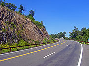
and Bear Mountain State Park
, descending to the river's level again to reach the popular picnic ground complex at Hessian Lake. Here the Appalachian Trail
(AT) crosses under the road to its lowest elevation in the nearby Trailside Zoo.
After ten miles (16 km), the US 9W concurrency comes to an end at Bear Mountain Circle, also the Palisades Parkway's north end. This puts US 202 very briefly in Orange County
, and US 6
replaces US 9W as the two join the AT in going through the tollbooths and crossing the Bear Mountain Bridge
. After a brief re-entry into Rockland County, the roads cross into Westchester County
.
, which begins to follow the river north to Beacon
and Wappingers Falls
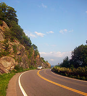
here. Routes 6 and 202 turn right to follow Bear Mountain Bridge Road
. The two wind around Anthony's Nose
high above the river, with occasional views to Haverstraw Bay
and the city of Peekskill to the south, and Dunderberg Mountain
, Iona Island
and the sections of US 9W the highway had just followed upriver.
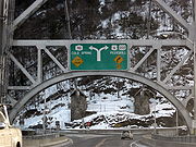
 Three and a half miles (6 km) US 6 and US 202 descend to river level again and, after passing the entrance to the New York National Guard base at Camp Smith, reach Annsville Circle. Here they form New York's only three-way concurrency of U.S. highways with US 9, then cross the Jan Peeck Bridge over Annsville Creek into the city and turn right onto the north end of the Croton Expressway
, while Bear Mountain Parkway begins to the east. At the second exit in Peekskill, the two routes leave US 9. NY 35
begins here and replaces it in the overlap, following Main Street across the city. At South Broad Street US 202 and NY 35 turn right while US 6 continues along Main, ending the first overlap between US 6 and US 202.
A few blocks to the south, US 202 and NY 35 turn left onto Crompond Road, which takes them out of Peekskill and back into the town of Cortlandt
. The two roads pass the Hudson Valley Hospital Center. Two miles later, Bear Mountain Parkway returns to US 202 for the eastern terminus of its western segment. Shortly afterwards it and Route 35 enter Yorktown
.
Here the road trends to the south, and the eastern segment of Bear Mountain Parkway branches off to the left to provide access to the Taconic State Parkway
, the main north–south trunk route for automobile traffic on the east side of the Hudson. An exit here allows access to neighboring Franklin D. Roosevelt State Park
.
 NY 132
, a short local road that leads north to Route 6, begins at Old Yorktown Road. After the next major intersection at Granite Springs Road, the concurrency turns to an almost due south heading for two miles (3 km), then bends southeast into the junction with Saw Mill River Road, NY 118
. Both routes turn north here, forming the third three-route overlap along US 202 in New York.
The north heading becomes northeast, then east into the town of Somers
to where NY 35 leaves US 202 and NY 118 at the southwest end of Amawalk Reservoir
, the first of several in the New York City water supply system along the road. US 202 and NY 118 turn left onto Tomahawk Street, closely hugging the reservoir's north shore, and then east shore after two miles (3 km), putting the road on a northern course. After crossing a small inlet at the reservoir's northwest corner, US 202 turns right, leaving NY 118. For the first time since Haverstraw, 38 miles (61 km) back, US 202 is alone, as it stays along the reservoir, heading northeast, then east, dipping south after the reservoir to pass north of Anglebrook Golf Club.
 At the club's northeast corner, it turns left, as Primrose Street, the road ahead, continues as NY 139
. After a mile, it turns right onto Mill Street, which becomes Somers Road shortly afterwards and curves to the south. At Brick Hill Road, it turns to a more northeast heading again, then east. This takes it into the center of town, where NY 100
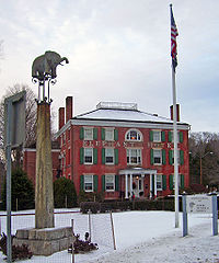
, Westchester's long north–south road, comes to its northern end just opposite the Elephant Hotel
, Somers' town hall and a National Historic Landmark
due to its role as the birthplace of the American circus
.
Now Somerstown Road, the highway resumes a due-northeast heading to where NY 116
forks off to the east towards Titicus Reservoir
. After this split, US 202 is now North Somerstown Road, headed northeast through generally wooded areas almost two miles (3 km) to the Croton River
, where it enters a new town, North Salem
. Here it forms its first concurrency in seven miles (11 km), joining with NY 22
, the long north–south route along New York's eastern boundary, just north of the hamlet of Croton Falls. After crossing under the Harlem Line of the Metro-North Railroad
, the two roads enter Putnam County
.
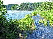 Routes 202 and 22 parallel the river and the railroad through similarly wooded country due northeast for the next two miles (3 km), with no intersections. The spillway of the lower section of East Branch Reservoir
appears on the right, and then the road follows the reservoir in the same direction to the eastern outskirts of the village of Brewster
. Here US 6 returns and gives US 202 its fourth three-way concurrency. Routes 6, 22 and 202 climb a small rise, cross under a rail freight spur and then pass through a developed area immediately south of the high quarter-mile bridge I-84
takes over the road and the river.
Just afterwards, the three routes turn left. The three-way overlap ends very soon afterwards at the next traffic light, where NY 22 turns left to pick up northbound traffic from I-684
, which ends at the nearby junction with its parent route. The ramps to I-84 and I-684 also leave here.
The road ahead bends south and then east, a four-lane divided road making use of the thin land between I-84 and the northern section of East Branch. There is one flashing yellow light, at the northern terminus of NY 121
, and then two miles (3 km) later, still next to the interstate, US 6 and US 202 cross into Danbury, Connecticut
alongside it just before the Saw Mill Road exit.
was known by several different designations. When the first set of posted routes in New York were assigned in 1924, the segment of what is now US 202 from the New Jersey
state line to Wayne Avenue in Suffern
was designated as part of NY 17
. At the same time, the part now concurrent
with US 9W
from Haverstraw
to the Bear Mountain Bridge
was included in NY 10
while the section between Croton Falls and Brewster
became part of NY 22
. By 1926, the Bear Mountain Bridge, the highway linking the bridge to Peekskill
, and the piece of current US 202 east of Brewster were designated as part of NY 37. Although all of what became US 202 was state-maintained by this point, no other sections of the route were assigned a designation by 1926.
Three portions of the route changed designations following the creation of the U.S. Highway System. In 1927, all of NY 10 south of Albany
was replaced by the newly assigned US 9W. NY 37, meanwhile, was replaced by a realigned US 6 one year later. In the late 1920s, the segment of modern US 202 from Suffern to Haverstraw was designated as NY 61. The last remaining unnumbered section—between Peekskill and Croton Falls—received a pair of designations as part of the 1930 renumbering of state highways in New York. From Peekskill to Somers
, it became part of NY 116
. At Somers, NY 116 continued east on its modern alignment toward Purdys while NY 118
followed modern US 202 northeast to Croton Falls.
Ca. 1934, NY 61 was supplanted by US 122, which was extended northward from Whitehouse, New Jersey
, by way of modern County Route 523
and US 202
. In Suffern, US 122 utilized a small part of NY 17, which was truncated to end at US 122 in the village center. US 122 was subsequently replaced by US 202
, a new U.S. Route established by the American Association of State Highway Officials in June 1934 that extended from Bangor, Maine
, to State Road, Delaware, south of Wilmington
. In New York, US 202 continued north from Haverstraw to the Bear Mountain Bridge over US 9W and east to Connecticut
by way of overlaps with US 6, NY 116, NY 118, and NY 22. The overlap with NY 116 was eliminated ca. 1938 when NY 116 was truncated to its current western terminus in Somers.
While the portion of US 202 in New York has remained relatively unchanged since the route's assignment in 1934, the overlapping routes have changed over time. Ca. 1939, the alignments of NY 118 and NY 100
north of New Croton Reservoir
were flipped, placing NY 100 on the Croton Reservoir – Croton Falls highway. The resulting overlap between NY 100 and US 202 lasted as late as 1990; however, it was eliminated by 2004 when NY 100 was cut back to end at US 202 in Somers. In the early 1940s, the portion of US 202 between Peekskill and Amawalk became part of NY 35
, an east–west route connecting Peekskill to Ridgefield, Connecticut
.
, the winding segment of US 6
and US 202 between NY 9D
and US 9 north of Peekskill
.
New Castle, Delaware
New Castle is a city in New Castle County, Delaware, six miles south of Wilmington, situated on the Delaware River. In 1900, 3,380 people lived here; in 1910, 3,351...
, to Bangor, Maine
Bangor, Maine
Bangor is a city in and the county seat of Penobscot County, Maine, United States, and the major commercial and cultural center for eastern and northern Maine...
. In the U.S. state
U.S. state
A U.S. state is any one of the 50 federated states of the United States of America that share sovereignty with the federal government. Because of this shared sovereignty, an American is a citizen both of the federal entity and of his or her state of domicile. Four states use the official title of...
of New York
New York
New York is a state in the Northeastern region of the United States. It is the nation's third most populous state. New York is bordered by New Jersey and Pennsylvania to the south, and by Connecticut, Massachusetts and Vermont to the east...
, US 202 extends 55.57 miles (89.43 km) from the New Jersey
New Jersey
New Jersey is a state in the Northeastern and Middle Atlantic regions of the United States. , its population was 8,791,894. It is bordered on the north and east by the state of New York, on the southeast and south by the Atlantic Ocean, on the west by Pennsylvania and on the southwest by Delaware...
state line near Suffern
Suffern, New York
Suffern is a village in the Town of Ramapo, Rockland County, New York, United States located north of the State of New Jersey; east of Hillburn; south of Montebello and west of Airmont...
to the Connecticut
Connecticut
Connecticut is a state in the New England region of the northeastern United States. It is bordered by Rhode Island to the east, Massachusetts to the north, and the state of New York to the west and the south .Connecticut is named for the Connecticut River, the major U.S. river that approximately...
state line east of Brewster
Brewster, New York
Brewster is a village within the town of Southeast in Putnam County, New York, United States. Its population was 2,162 at the 2000 census. The village is the most densely populated portion of the town...
. While most of US 202 is signed north–south, the portion within New York is signed east–west. It drifts north slowly as it crosses southern New York. US 202 is the only road to cross New York between New Jersey and Connecticut and not pass through New York City
New York City
New York is the most populous city in the United States and the center of the New York Metropolitan Area, one of the most populous metropolitan areas in the world. New York exerts a significant impact upon global commerce, finance, media, art, fashion, research, technology, education, and...
on the way.
As it does in other states, Route 202 serves mainly as a local road in suburban and exurban communities along the outskirts of the metropolitan area, mostly two lanes with the exception of some four-lane sections and a brief concurrency
Concurrency (road)
A concurrency, overlap, or coincidence in a road network is an instance of one physical road bearing two or more different highway, motorway, or other route numbers...
onto an expressway in Peekskill
Peekskill, New York
Peekskill is a city in Westchester County, New York. It is situated on a bay along the east side of the Hudson River, across from Jones Point.This community was known to be an early American industrial center, primarily for its iron plow and stove products...
. Its course along the Hudson River
Hudson River
The Hudson is a river that flows from north to south through eastern New York. The highest official source is at Lake Tear of the Clouds, on the slopes of Mount Marcy in the Adirondack Mountains. The river itself officially begins in Henderson Lake in Newcomb, New York...
takes it first north up the west side, over the historic Bear Mountain Bridge
Bear Mountain Bridge
The Bear Mountain Bridge is a toll suspension bridge in New York State, carrying U.S. Highways 202 and 6 across the Hudson River between Rockland and Westchester counties...
, then south along the east side. It takes in many scenic areas, such as the Ramapo Mountains
Ramapo Mountains
The Ramapo Mountains are a forested chain of the Appalachian mountains in northeastern New Jersey and southeastern New York in the United States...
and Hudson Highlands
Hudson Highlands
The Hudson Highlands are mountains on both sides of the Hudson River in the U.S. state of New York, between Newburgh Bay and Haverstraw Bay, which form the northern region of the New York - New Jersey Highlands....
, and two New York City reservoirs.
Its circuitous path across the state puts it on many concurrencies—only 14.5 miles (23.3 km), or 26%, of Route 202's mileage in New York is signed as US 202 alone. Among the roads it joins are three U.S. highways and two state routes. It forms four three-route conurrencies, including the only such grouping of three U.S. routes in the state, again in Peekskill.
Route description
US 202's New York stretch is roughly bisected by the Hudson RiverHudson River
The Hudson is a river that flows from north to south through eastern New York. The highest official source is at Lake Tear of the Clouds, on the slopes of Mount Marcy in the Adirondack Mountains. The river itself officially begins in Henderson Lake in Newcomb, New York...
. West of it, the highway runs northeast, east and north along the edge of suburbia in Rockland County to Bear Mountain Bridge
Bear Mountain Bridge
The Bear Mountain Bridge is a toll suspension bridge in New York State, carrying U.S. Highways 202 and 6 across the Hudson River between Rockland and Westchester counties...
; to the east, it follows a mainly east–west orientation except for the New York State Route 22 (NY 22) concurrency between Croton Falls and Brewster. It is mostly a two-lane road, expanding to four in some busier sections, with a brief limited-access stretch in Peekskill.
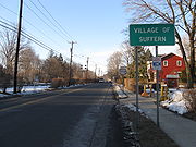
Rockland County
The left turn that brings US 202 into New York and the village of SuffernSuffern, New York
Suffern is a village in the Town of Ramapo, Rockland County, New York, United States located north of the State of New Jersey; east of Hillburn; south of Montebello and west of Airmont...
puts it on Orange Avenue, paralleling the old Main Line
Main Line (NJ Transit)
The Main Line is a rail line owned and operated by New Jersey Transit running from Suffern, New York to Hoboken, New Jersey. It runs daily commuter service and was once the north-south main line of the Erie Lackawanna Railroad...
of the Erie Railroad
Erie Railroad
The Erie Railroad was a railroad that operated in New York State, New Jersey, Pennsylvania, Ohio, Indiana, and Illinois, originally connecting New York City with Lake Erie...
past the Suffern train station and into the village's downtown. In the shadow of the New York State Thruway
New York State Thruway
The New York State Thruway is a system of limited-access highways located within the state of New York in the United States. The system, known officially as the Governor Thomas E. Dewey Thruway for former New York Governor Thomas E. Dewey, is operated by the New York State Thruway Authority and...
, it meets its first New York state highway, NY 59
New York State Route 59
New York State Route 59 is an east–west state highway in southern Rockland County, New York, in the United States. The route extends for from NY 17 in Hillburn to U.S. Route 9W in Nyack. In Suffern, it has a concurrency with US 202 for . NY 59 runs parallel to the New...
, and has a brief wrong-way concurrency with it.
Somerville, New Jersey
Somerville is a borough in Somerset County, New Jersey, United States. As of the 2010 United States Census, the borough population was 12,098. It is the county seat of Somerset County....
. It remains a two-lane route at the edge of development past Pomona
Pomona, New York
Pomona is a village partly in the Town of Ramapo and partly in the Town of Haverstraw in Rockland County, New York, United States, located north of New Hempstead, east of Harriman State Park, north of Monsey and west of Mount Ivy. According to the 2010 Census, the population was 3,103, a 13 percent...
and Montebello
Montebello, New York
Montebello is a village in the town of Ramapo Rockland County, New York, United States. It is located north of Suffern, east of Hillburn, south of Wesley Hills and west of Airmont...
, at the foot of the Ramapo Mountains
Ramapo Mountains
The Ramapo Mountains are a forested chain of the Appalachian mountains in northeastern New Jersey and southeastern New York in the United States...
, home to the vast Harriman State Park. The headwaters of the Mahwah River
Mahwah River
The Mahwah River runs on a meandering SSW course for about 11 mi from its headwaters just north of the hamlet of Ladentown, New York to its mouth which empties into the Ramapo River in Mahwah, New Jersey, just south of the village of Suffern, New York, and the state line...
parallel closely.
At Ladentown, the northern terminus of NY 306
New York State Route 306
New York State Route 306 is a north–south state highway in western Rockland County, New York in the United States. NY 306 runs from NY 59 in the hamlet of Monsey to U.S. Route 202 in Ladentown, on the western boundary of the village of Pomona...
, the road begins to curve to the east, away from the ridge. Route 202 widens as it cuts across the county, still a little less developed here, towards Mount Ivy
Mount Ivy, New York
Mount Ivy is a hamlet in the towns of Haverstraw and Ramapo New York, United States located north of New City; east of Pomona; south of Thiells and west of the Garnerville...
, where it has a full exit with Palisades Interstate Parkway
Palisades Interstate Parkway
The Palisades Interstate Parkway is a long limited-access highway in the U.S. states of New Jersey and New York. The parkway is a major commuter route into New York City from Rockland and Orange counties in New York and Bergen County in New Jersey...
and NY 45
New York State Route 45
New York State Route 45 is a north–south state highway in central Rockland County, New York, United States. It spans from the village of Chestnut Ridge at the New Jersey – New York border, where it becomes County Route 73 in Bergen County, New Jersey, to U.S. Route 202 in...
. The Long Path
Long Path
The Long Path is a long-distance hiking trail beginning at the George Washington Bridge in Fort Lee, New Jersey and currently ending at Altamont, New York, in the Albany area...
hiking trail also crosses here. Beyond this junction US 202 is a four-lane undivided road, surrounded mainly by office parks and commercial establishments, but not strip development, as it follows the curve of South Mountain to the south.
West Haverstraw, New York
West Haverstraw is a village in the Town of Haverstraw Rockland County, New York, United States located northwest of the Village of Haverstraw; east of Thiells; south of the Hamlet of Stony Point and west of the Hudson River. The population was 10,295 at the 2000 census...
, and at Haverstraw
Haverstraw, New York
Haverstraw is the name of two locations in Rockland County, New York:*Haverstraw, New York, a town*Haverstraw , New York, a village located entirely within the townIt may also refer to:*West Haverstraw, New York*Haverstraw Bay*Haverstraw Indians...
, the road makes an oblique intersection with US 9W
U.S. Route 9W
U.S. Route 9W is a north–south U.S. Highway in the states of New Jersey and New York. It begins on Fletcher Avenue in Fort Lee, New Jersey as it crosses the US 1 & 9, US 46, and the Interstate 95 approaches to the George Washington Bridge, where it heads north up the west...
and joins it, following the Hudson River
Hudson River
The Hudson is a river that flows from north to south through eastern New York. The highest official source is at Lake Tear of the Clouds, on the slopes of Mount Marcy in the Adirondack Mountains. The river itself officially begins in Henderson Lake in Newcomb, New York...
north through Stony Point
Stony Point, New York
Stony Point is a triangle-shaped town in Rockland County, United States. Rockland County is part of the New York Metropolitan Area. The town is located north of the town of Haverstraw, east and south of Orange County, New York, and west of the Hudson River and Westchester County. The population...
and then climbing the mountains near Jones Point
Jones Point, New York
Jones Point is a hamlet located in the town of Stony Point in Rockland County in the state of New York, United States. Located north of Tomkins Cove; east of Bear Mountain State Park; south of Iona Island; and west of the Hudson River...
and Bear Mountain State Park
Bear Mountain State Park
Bear Mountain State Park is located on the west side of the Hudson River in Orange and Rockland counties of New York. The park offers biking, hiking, boating, picnicking, swimming, cross-country skiing, cross-country running, sledding and ice skating...
, descending to the river's level again to reach the popular picnic ground complex at Hessian Lake. Here the Appalachian Trail
Appalachian Trail
The Appalachian National Scenic Trail, generally known as the Appalachian Trail or simply the AT, is a marked hiking trail in the eastern United States extending between Springer Mountain in Georgia and Mount Katahdin in Maine. It is approximately long...
(AT) crosses under the road to its lowest elevation in the nearby Trailside Zoo.
After ten miles (16 km), the US 9W concurrency comes to an end at Bear Mountain Circle, also the Palisades Parkway's north end. This puts US 202 very briefly in Orange County
Orange County, New York
Orange County is a county located in the U.S. state of New York. It is part of the Poughkeepsie–Newburgh–Middletown, NY Metropolitan Statistical Area and is located at the northern reaches of the New York metropolitan area. The county sits in the state's scenic Mid-Hudson Region of the Hudson Valley...
, and US 6
U.S. Route 6 in New York
U.S. Route 6 is a part of the U.S. Highway System that runs from Bishop, California, to Provincetown, Massachusetts. In New York, US 6 extends from the Pennsylvania state line at Port Jervis to the Connecticut state line east of Brewster...
replaces US 9W as the two join the AT in going through the tollbooths and crossing the Bear Mountain Bridge
Bear Mountain Bridge
The Bear Mountain Bridge is a toll suspension bridge in New York State, carrying U.S. Highways 202 and 6 across the Hudson River between Rockland and Westchester counties...
. After a brief re-entry into Rockland County, the roads cross into Westchester County
Westchester County, New York
Westchester County is a county located in the U.S. state of New York. Westchester covers an area of and has a population of 949,113 according to the 2010 Census, residing in 45 municipalities...
.
East of Hudson
In most of northern Westchester, US 202, primarily as part of concurrencies, serves as a local road between the towns it passes through. It skirts the one Putnam County village along its path, and is mostly a rural road in that county, expanded to four lines at its easternmost portion.Westchester County
At the end of the bridge the AT leaves with NY 9DNew York State Route 9D
New York State Route 9D , also known as the Bear Mountain – Beacon Highway, is a north–south state highway that runs along the eastern shore of the Hudson River in New York in the United States. It starts at the eastern end of the Bear Mountain Bridge at U.S...
, which begins to follow the river north to Beacon
Beacon, New York
Beacon is a city located in Dutchess County, New York, United States. The 2010 census placed the city total population at 15,541. Beacon is part of the Poughkeepsie–Newburgh–Middletown, NY Metropolitan Statistical Area as well as the larger New York–Newark–Bridgeport,...
and Wappingers Falls
Wappingers Falls, New York
Wappingers Falls is a village in Dutchess County, New York, United States. The name is derived from the local Wappinger Indians. One half of the village is in the town of Wappinger and the other half is in the town of Poughkeepsie, with Wappinger Creek forming the dividing line between the...
here. Routes 6 and 202 turn right to follow Bear Mountain Bridge Road
Bear Mountain Bridge Road
Bear Mountain Bridge Road is a three-mile , two-lane section of US 6/202 from the west approach to Bear Mountain Bridge to a former toll house in the Town of Cortlandt, New York, United States. It winds around the steep, rocky slopes of Anthony's Nose, the southernmost peak of the Hudson Highlands...
. The two wind around Anthony's Nose
Anthony's Nose (Westchester)
Anthony's Nose is a peak along the Hudson River at the north end of Westchester County, New York.- Topography :Anthony's Nose, together with Dunderberg Mountain, comprises the South Gate of the Hudson Highlands...
high above the river, with occasional views to Haverstraw Bay
Haverstraw Bay
Haverstraw Bay, located in New York, is the widest portion of the Hudson River. The width of Haverstraw Bay is approximately 3.4 miles . The length approximately 5 miles from river kilometer 58 at Croton Point to river kilometer 66 at Stony Point...
and the city of Peekskill to the south, and Dunderberg Mountain
Dunderberg Mountain
Dunderberg Mountain stands at the so-called southern gate of the Hudson Highlands where the region's namesake Hudson River enters a dramatic gorge...
, Iona Island
Iona Island
Iona Island may refer to:*Iona, an island in the Inner Hebrides, Scotland*Iona Island *Iona Island...
and the sections of US 9W the highway had just followed upriver.
Croton Expressway
U.S. Route 9 is a part of the U.S. Highway System that runs from Laurel, Delaware, to Champlain, New York. In New York, US 9 extends from the George Washington Bridge in Manhattan to an interchange with Interstate 87 just south of the Canada – United States border in the town...
, while Bear Mountain Parkway begins to the east. At the second exit in Peekskill, the two routes leave US 9. NY 35
New York State Route 35
New York State Route 35 is the principal east–west highway in the northern part of Westchester County, New York, carrying average daily volumes of around 16,500 vehicles...
begins here and replaces it in the overlap, following Main Street across the city. At South Broad Street US 202 and NY 35 turn right while US 6 continues along Main, ending the first overlap between US 6 and US 202.
A few blocks to the south, US 202 and NY 35 turn left onto Crompond Road, which takes them out of Peekskill and back into the town of Cortlandt
Cortlandt, New York
Cortlandt is a town in Westchester County, New York, United States. The population was 41,592 at the 2010 census.The Town of Cortlandt is in the northwest part of the county...
. The two roads pass the Hudson Valley Hospital Center. Two miles later, Bear Mountain Parkway returns to US 202 for the eastern terminus of its western segment. Shortly afterwards it and Route 35 enter Yorktown
Yorktown, New York
Yorktown is a town in Westchester County, New York, in the suburbs of New York about north of midtown Manhattan. The town lies on the north border of Westchester County...
.
Here the road trends to the south, and the eastern segment of Bear Mountain Parkway branches off to the left to provide access to the Taconic State Parkway
Taconic State Parkway
The Taconic State Parkway , is a divided highway between Kensico Dam and Chatham, the longest parkway in the U.S. state of New York. It follows a generally northward route midway between the Hudson River and the Connecticut and Massachusetts state lines...
, the main north–south trunk route for automobile traffic on the east side of the Hudson. An exit here allows access to neighboring Franklin D. Roosevelt State Park
Franklin D. Roosevelt State Park
Franklin D. Roosevelt State Park is a state park in Westchester County, New York. It was formerly known as Mohansic Park and Mohansic State Park and is situated in Yorktown, about 40 miles from New York City...
.
New York State Route 132
New York State Route 132 is a long state highway located entirely within the Town of Yorktown in Westchester County, New York. The route acts as a connector between U.S. Route 202 and NY 35 in the south and U.S. Route 6 in the north...
, a short local road that leads north to Route 6, begins at Old Yorktown Road. After the next major intersection at Granite Springs Road, the concurrency turns to an almost due south heading for two miles (3 km), then bends southeast into the junction with Saw Mill River Road, NY 118
New York State Route 118
New York State Route 118 is a north–south state highway that extends for in Downstate New York in the United States. Much of the highway is located within Westchester County; however, a small portion of the route near the northern terminus is situated in Putnam County...
. Both routes turn north here, forming the third three-route overlap along US 202 in New York.
The north heading becomes northeast, then east into the town of Somers
Somers, New York
Somers is a town located in northeastern Westchester County, New York, United States. As of the 2010 census, the town had a population of 20,434...
to where NY 35 leaves US 202 and NY 118 at the southwest end of Amawalk Reservoir
Amawalk Reservoir
The Amawalk Reservoir is a small reservoir in central-northern Westchester County, New York. It is located at the intersection of U.S. Route 202 and New York State Route 35 in the town of Somers, and is over 32 miles north of New York City. It was formed by impounding the middle of the...
, the first of several in the New York City water supply system along the road. US 202 and NY 118 turn left onto Tomahawk Street, closely hugging the reservoir's north shore, and then east shore after two miles (3 km), putting the road on a northern course. After crossing a small inlet at the reservoir's northwest corner, US 202 turns right, leaving NY 118. For the first time since Haverstraw, 38 miles (61 km) back, US 202 is alone, as it stays along the reservoir, heading northeast, then east, dipping south after the reservoir to pass north of Anglebrook Golf Club.
New York State Route 139
New York State Route 139 is a long state highway in the town of Somers in Westchester County, New York, in the United States. It connects the hamlet of Whitehall Corners at NY 100 with the hamlet of Lincolndale at U.S. Route 202. The entirety of NY 139, known as Primrose...
. After a mile, it turns right onto Mill Street, which becomes Somers Road shortly afterwards and curves to the south. At Brick Hill Road, it turns to a more northeast heading again, then east. This takes it into the center of town, where NY 100
New York State Route 100
New York State Route 100 is a major north–south state highway in Westchester County, New York, in the United States. It begins parallel to Interstate 87 at a junction with the Cross County Parkway in the city of Yonkers and runs through most of the length of the county via the city of...
, Westchester's long north–south road, comes to its northern end just opposite the Elephant Hotel
Elephant Hotel
You may be looking for the Coney Island elephant hotel, also known as Lucy the Elephant.The Elephant Hotel is a National Historic Landmark located in Somers, New York, a town in Westchester County, New York, USA. It was listed on the National Register of Historic Places in 1974 as Somers Town...
, Somers' town hall and a National Historic Landmark
National Historic Landmark
A National Historic Landmark is a building, site, structure, object, or district, that is officially recognized by the United States government for its historical significance...
due to its role as the birthplace of the American circus
Circus
A circus is commonly a travelling company of performers that may include clowns, acrobats, trained animals, trapeze acts, musicians, hoopers, tightrope walkers, jugglers, unicyclists and other stunt-oriented artists...
.
Now Somerstown Road, the highway resumes a due-northeast heading to where NY 116
New York State Route 116
New York State Route 116 is an east–west state highway in Westchester County, New York, in the United States. It extends for from an intersection with U.S. Route 202 in the hamlet of Somers to the Connecticut state line, where it becomes that state's Route 116...
forks off to the east towards Titicus Reservoir
Titicus Reservoir
Titicus Reservoir is one of 12 in the New York City Water Supply System's Croton watershed. It is located in the Town of North Salem in Westchester County, 30 miles north of the city.At full capacity it holds 7.2 billion gallons...
. After this split, US 202 is now North Somerstown Road, headed northeast through generally wooded areas almost two miles (3 km) to the Croton River
Croton River
The Croton River is a river in southern New York that begins where the East and West Branches of the Croton River meet a little way downstream from the Croton Falls Reservoir...
, where it enters a new town, North Salem
North Salem, New York
North Salem is a town in the northeast part of Westchester County, New York, United States. The county ranks second for wealthiest counties in New York State and the seventh wealthiest county nationally...
. Here it forms its first concurrency in seven miles (11 km), joining with NY 22
New York State Route 22
New York State Route 22 is a north–south state highway in eastern New York in the United States. It runs parallel to the state's eastern edge from the outskirts of New York City to a short distance south of the Canadian border. At , it is the state's longest north–south route and...
, the long north–south route along New York's eastern boundary, just north of the hamlet of Croton Falls. After crossing under the Harlem Line of the Metro-North Railroad
Metro-North Railroad
The Metro-North Commuter Railroad , trading as MTA Metro-North Railroad, or, more commonly, Metro-North, is a suburban commuter rail service that is run and managed by the Metropolitan Transportation Authority , an authority of New York State. It is the busiest commuter railroad in the United...
, the two roads enter Putnam County
Putnam County, New York
Putnam County is a county located in the U.S. state of New York, in the lower Hudson River Valley. Putnam county formed in 1812, when it detached from Dutchess County. , the population was 99,710. It is part of the New York Metropolitan Area. The county seat is the hamlet of Carmel...
.
Putnam County
East Branch Reservoir
East Branch Reservoir, formed by impounding the eponymous branch of the Croton River, is part of New York City's water supply network. It is located in the Putnam County town of Southeast, near the village of Brewster 35 miles north of the city....
appears on the right, and then the road follows the reservoir in the same direction to the eastern outskirts of the village of Brewster
Brewster, New York
Brewster is a village within the town of Southeast in Putnam County, New York, United States. Its population was 2,162 at the 2000 census. The village is the most densely populated portion of the town...
. Here US 6 returns and gives US 202 its fourth three-way concurrency. Routes 6, 22 and 202 climb a small rise, cross under a rail freight spur and then pass through a developed area immediately south of the high quarter-mile bridge I-84
Interstate 84 in New York
Interstate 84 is a part of the Interstate Highway System that runs from Dunmore, Pennsylvania, to Sturbridge, Massachusetts, in the Eastern United States. In New York, I-84 extends from the Pennsylvania state line at Port Jervis to the Connecticut state line east of Brewster...
takes over the road and the river.
Just afterwards, the three routes turn left. The three-way overlap ends very soon afterwards at the next traffic light, where NY 22 turns left to pick up northbound traffic from I-684
Interstate 684
Interstate 684 is a 28.4 mile-long north–south Interstate Highway in the states of New York and Connecticut. The highway connects I-84 with I-287 and the Hutchinson River Parkway, primarily serving commuter traffic to and from the northern suburbs of the New York metropolitan area...
, which ends at the nearby junction with its parent route. The ramps to I-84 and I-684 also leave here.
The road ahead bends south and then east, a four-lane divided road making use of the thin land between I-84 and the northern section of East Branch. There is one flashing yellow light, at the northern terminus of NY 121
New York State Route 121
New York State Route 121 is a north–south state highway in New York, going from northern Westchester County to the village of Brewster in Putnam County.-Route description:...
, and then two miles (3 km) later, still next to the interstate, US 6 and US 202 cross into Danbury, Connecticut
Danbury, Connecticut
Danbury is a city in northern Fairfield County, Connecticut, United States. It had population at the 2010 census of 80,893. Danbury is the fourth largest city in Fairfield County and is the seventh largest city in Connecticut....
alongside it just before the Saw Mill Road exit.
History
Prior to 1934, the portion of modern US 202 within New YorkNew York
New York is a state in the Northeastern region of the United States. It is the nation's third most populous state. New York is bordered by New Jersey and Pennsylvania to the south, and by Connecticut, Massachusetts and Vermont to the east...
was known by several different designations. When the first set of posted routes in New York were assigned in 1924, the segment of what is now US 202 from the New Jersey
New Jersey
New Jersey is a state in the Northeastern and Middle Atlantic regions of the United States. , its population was 8,791,894. It is bordered on the north and east by the state of New York, on the southeast and south by the Atlantic Ocean, on the west by Pennsylvania and on the southwest by Delaware...
state line to Wayne Avenue in Suffern
Suffern, New York
Suffern is a village in the Town of Ramapo, Rockland County, New York, United States located north of the State of New Jersey; east of Hillburn; south of Montebello and west of Airmont...
was designated as part of NY 17
New York State Route 17
New York State Route 17 is a state highway that extends for through the Southern Tier and Downstate regions of New York in the United States...
. At the same time, the part now concurrent
Concurrency (road)
A concurrency, overlap, or coincidence in a road network is an instance of one physical road bearing two or more different highway, motorway, or other route numbers...
with US 9W
U.S. Route 9W
U.S. Route 9W is a north–south U.S. Highway in the states of New Jersey and New York. It begins on Fletcher Avenue in Fort Lee, New Jersey as it crosses the US 1 & 9, US 46, and the Interstate 95 approaches to the George Washington Bridge, where it heads north up the west...
from Haverstraw
Haverstraw (village), New York
Haverstraw is a village in the town of Haverstraw in Rockland County, New York, United States located north of Congers; southeast of West Haverstraw; east of Garnerville, New York; northeast of New City and west of the Hudson River at its widest point...
to the Bear Mountain Bridge
Bear Mountain Bridge
The Bear Mountain Bridge is a toll suspension bridge in New York State, carrying U.S. Highways 202 and 6 across the Hudson River between Rockland and Westchester counties...
was included in NY 10
New York State Route 10
New York State Route 10 is a north–south state highway in the Central New York and North Country regions of New York in the United States. It extends for from the Quickway in Deposit, Delaware County to NY 8 at Higgins Bay, a hamlet in the Hamilton County town of Arietta...
while the section between Croton Falls and Brewster
Brewster, New York
Brewster is a village within the town of Southeast in Putnam County, New York, United States. Its population was 2,162 at the 2000 census. The village is the most densely populated portion of the town...
became part of NY 22
New York State Route 22
New York State Route 22 is a north–south state highway in eastern New York in the United States. It runs parallel to the state's eastern edge from the outskirts of New York City to a short distance south of the Canadian border. At , it is the state's longest north–south route and...
. By 1926, the Bear Mountain Bridge, the highway linking the bridge to Peekskill
Peekskill, New York
Peekskill is a city in Westchester County, New York. It is situated on a bay along the east side of the Hudson River, across from Jones Point.This community was known to be an early American industrial center, primarily for its iron plow and stove products...
, and the piece of current US 202 east of Brewster were designated as part of NY 37. Although all of what became US 202 was state-maintained by this point, no other sections of the route were assigned a designation by 1926.
Three portions of the route changed designations following the creation of the U.S. Highway System. In 1927, all of NY 10 south of Albany
Albany, New York
Albany is the capital city of the U.S. state of New York, the seat of Albany County, and the central city of New York's Capital District. Roughly north of New York City, Albany sits on the west bank of the Hudson River, about south of its confluence with the Mohawk River...
was replaced by the newly assigned US 9W. NY 37, meanwhile, was replaced by a realigned US 6 one year later. In the late 1920s, the segment of modern US 202 from Suffern to Haverstraw was designated as NY 61. The last remaining unnumbered section—between Peekskill and Croton Falls—received a pair of designations as part of the 1930 renumbering of state highways in New York. From Peekskill to Somers
Somers, New York
Somers is a town located in northeastern Westchester County, New York, United States. As of the 2010 census, the town had a population of 20,434...
, it became part of NY 116
New York State Route 116
New York State Route 116 is an east–west state highway in Westchester County, New York, in the United States. It extends for from an intersection with U.S. Route 202 in the hamlet of Somers to the Connecticut state line, where it becomes that state's Route 116...
. At Somers, NY 116 continued east on its modern alignment toward Purdys while NY 118
New York State Route 118
New York State Route 118 is a north–south state highway that extends for in Downstate New York in the United States. Much of the highway is located within Westchester County; however, a small portion of the route near the northern terminus is situated in Putnam County...
followed modern US 202 northeast to Croton Falls.
Ca. 1934, NY 61 was supplanted by US 122, which was extended northward from Whitehouse, New Jersey
Whitehouse, New Jersey
Whitehouse is a village in Readington Township, New Jersey along the Jersey Turnpike, just west of Mechanicsville.In 1722, Abraham Van Horn purchased in Readington along the Rockaway Creek. He built a grist mill and saw mill here...
, by way of modern County Route 523
County Route 523 (New Jersey)
County Route 523 is a county highway in the U.S. state of New Jersey. The highway extends from Main Street in Stockton to Hillside Avenue in Bedminster Township.-Hunterdon County:...
and US 202
U.S. Route 202 in New Jersey
U.S. Route 202 is a U.S. Highway running from New Castle, Delaware northeast to Bangor, Maine. In the U.S. state of New Jersey, the route runs from the New Hope-Lambertville Toll Bridge over the Delaware River at the Pennsylvania border in Delaware Township, Hunterdon County near Lambertville...
. In Suffern, US 122 utilized a small part of NY 17, which was truncated to end at US 122 in the village center. US 122 was subsequently replaced by US 202
U.S. Route 202
U.S. Route 202 is a highway stretching from Delaware to Maine, also passing through the states of Pennsylvania, New Jersey, New York, Connecticut, Massachusetts, and New Hampshire....
, a new U.S. Route established by the American Association of State Highway Officials in June 1934 that extended from Bangor, Maine
Bangor, Maine
Bangor is a city in and the county seat of Penobscot County, Maine, United States, and the major commercial and cultural center for eastern and northern Maine...
, to State Road, Delaware, south of Wilmington
Wilmington, Delaware
Wilmington is the largest city in the state of Delaware, United States, and is located at the confluence of the Christina River and Brandywine Creek, near where the Christina flows into the Delaware River. It is the county seat of New Castle County and one of the major cities in the Delaware Valley...
. In New York, US 202 continued north from Haverstraw to the Bear Mountain Bridge over US 9W and east to Connecticut
Connecticut
Connecticut is a state in the New England region of the northeastern United States. It is bordered by Rhode Island to the east, Massachusetts to the north, and the state of New York to the west and the south .Connecticut is named for the Connecticut River, the major U.S. river that approximately...
by way of overlaps with US 6, NY 116, NY 118, and NY 22. The overlap with NY 116 was eliminated ca. 1938 when NY 116 was truncated to its current western terminus in Somers.
While the portion of US 202 in New York has remained relatively unchanged since the route's assignment in 1934, the overlapping routes have changed over time. Ca. 1939, the alignments of NY 118 and NY 100
New York State Route 100
New York State Route 100 is a major north–south state highway in Westchester County, New York, in the United States. It begins parallel to Interstate 87 at a junction with the Cross County Parkway in the city of Yonkers and runs through most of the length of the county via the city of...
north of New Croton Reservoir
New Croton Reservoir
The New Croton reservoir is a narrow reservoir in Westchester County, New York, lying approximately north of New York City, for which the reservoir supplies water. It is the collecting point for water from all reservoirs in the Croton Watershed....
were flipped, placing NY 100 on the Croton Reservoir – Croton Falls highway. The resulting overlap between NY 100 and US 202 lasted as late as 1990; however, it was eliminated by 2004 when NY 100 was cut back to end at US 202 in Somers. In the early 1940s, the portion of US 202 between Peekskill and Amawalk became part of NY 35
New York State Route 35
New York State Route 35 is the principal east–west highway in the northern part of Westchester County, New York, carrying average daily volumes of around 16,500 vehicles...
, an east–west route connecting Peekskill to Ridgefield, Connecticut
Ridgefield, Connecticut
Ridgefield is a town in Fairfield County, Connecticut, United States. Situated in the foothills of the Berkshire Mountains, the 300-year-old community had a population of 24,638 at the 2010 census. The town center, which was formerly a borough, is defined by the U.S...
.
US 6/202 Alternate
U.S. Route 6/202 Alternate is a 10.5 miles (16.9 km) bypass of Bear Mountain Bridge RoadBear Mountain Bridge Road
Bear Mountain Bridge Road is a three-mile , two-lane section of US 6/202 from the west approach to Bear Mountain Bridge to a former toll house in the Town of Cortlandt, New York, United States. It winds around the steep, rocky slopes of Anthony's Nose, the southernmost peak of the Hudson Highlands...
, the winding segment of US 6
U.S. Route 6 in New York
U.S. Route 6 is a part of the U.S. Highway System that runs from Bishop, California, to Provincetown, Massachusetts. In New York, US 6 extends from the Pennsylvania state line at Port Jervis to the Connecticut state line east of Brewster...
and US 202 between NY 9D
New York State Route 9D
New York State Route 9D , also known as the Bear Mountain – Beacon Highway, is a north–south state highway that runs along the eastern shore of the Hudson River in New York in the United States. It starts at the eastern end of the Bear Mountain Bridge at U.S...
and US 9 north of Peekskill
Peekskill, New York
Peekskill is a city in Westchester County, New York. It is situated on a bay along the east side of the Hudson River, across from Jones Point.This community was known to be an early American industrial center, primarily for its iron plow and stove products...
.