
New York State Route 82
Encyclopedia
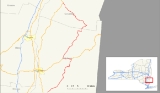
New York State Route 82 (NY 82) is a state highway
in the eastern Hudson Valley
of New York
, United States
. It begins at an intersection with NY 52
northeast of the village of Fishkill, bends eastward towards Millbrook
, and then returns westward to end at a junction with U.S. Route 9, NY 9H
, and NY 23
at Bell Pond, near Claverack
. NY 82 meets the Taconic State Parkway
twice; it is the only state highway that has more than one exit with the parkway. The road spans two counties: Dutchess
and Columbia
.
NY 82 was assigned as part of the 1930 renumbering of state highways in New York. An alternate route of NY 82 from South Millbrook to Pine Plains
, designated as New York State Route 82A, was assigned at the same time. Part of NY 82A was replaced by the new U.S. Route 44 ca. 1935. The routings of NY 82 and NY 82A were swapped in the mid-1930s, but the change was reverted in the mid-1960s. Ownership and maintenance of NY 82A was transferred from the state of New York to Dutchess County in 1980, at which time it was redesignated as County Route 83.
. The route proceeds to the northeast, paralleling the path of the Fishkill Creek
through southern Dutchess County
. At the East Fishkill
hamlet of Hopewell Junction, NY 82 briefly overlaps NY 376
before separating from the waterway east of the hamlet. NY 82 continues north to the community of Arthursburg, where it meets the Taconic State Parkway
at an interchange. Past the exit, the two roads begin to follow parallel routings through the center of the county. To the north in Billings, NY 82 intersects NY 55
before continuing onward toward the village of Millbrook
. South of Millbrook, NY 82 turns to the west at an intersection with NY 343
. Midway between Millbrook and the Taconic Parkway, NY 82 meets U.S. Route 44 and overlaps the route for a short distance to the west. The two routes separate just east of where US 44 meets the parkway.
 North of the split with US 44, NY 82 passes through the former hamlet of Bloomvale
. It then leaves the vicinity of the parkway and begins to parallel Wappinger Creek
as it heads through the northern extent of Dutchess County. At Pine Plains
, the creek terminates while NY 82 intersects NY 199
in the center of the hamlet. NY 82 turns east, forming a brief overlap with NY 199 before splitting outside of the community. Shortly after leaving NY 199, NY 82 passes into Columbia County
.
 Within Columbia County, NY 82 maintains a predominantly northwest–southeast routing. From the county line northward, NY 82 passes through Ancramdale and Ancram
prior to meeting the Taconic Parkway a second time near the Lake Taghkanic State Park
in West Taghkanic. Past the Taconic, NY 82 continues onward to Bell Pond, where it terminates at an intersection with U.S. Route 9, NY 9H
, and NY 23
.
extending from New York City
to Rensselaer
. Route 1 left modern NY 22
at the hamlet of Amenia
and followed what is now U.S. Route 44 west to Smithfield Valley Road. From there, the route headed north through the town of North East
and northwest through the town of Pine Plains
to the community of Pine Plains
by way of Smithfield Valley Road. Route 1 continued northward on Silvernails and Gallatinville Roads and modern County Route 7 to the hamlet of Ancram
, where it turned northeast to follow today's CR 7 toward Copake
. On March 1, 1921, Route 1 was realigned between Amenia and Copake to use modern NY 22
instead.
 In the 1930 renumbering of state highways in New York, the portion of pre-1921 legislative Route 1 between Pine Plains and Ancram became part of NY 82, a new route extending from the vicinity of the village of Fishkill in the south to the town of Livingston
in the north. At the same time, the segment of old Route 1 from Amenia to Pine Plains became part of NY 82A, an alternate route of NY 82 between the hamlets of South Millbrook and Pine Plains by way of Amenia.
becoming NY 82A. From South Millbrook to Amenia, NY 82 overlapped US 44.
NY 82 has been realigned twice between Pine Plains and Ancram since its assignment. Ca. 1935, the route was altered to bypass Gallatinville Road and continue on Silvernails Road to the hamlet of Silvernails, where it met modern County Route 7. In the early 1950s, NY 82 was changed to exit Pine Plains to the east by way of an overlap with NY 199
. At Hammertown, the two routes split and NY 82 continued north to Ancram by way of Ancramdale. Between Ancramdale and Ancram, NY 82 replaced NY 201, a route originally assigned as part of the 1930 renumbering.
In the mid-1960s, NY 82 and NY 82A were restored to their ca. 1935 alignments, with NY 82 routed through Washington's Hollow and NY 82A beginning in Amenia. On April 1, 1980, ownership and maintenance of NY 82A was transferred from the state of New York
to Dutchess County
as part of a highway maintenance swap between the two levels of government. Also transferred from the state to the county was the portion of NY 82's original routing in Pine Plains between NY 199 and Silvernails Road. Following the swap, NY 82A was redesignated as County Route 83 while NY 82's former routing in Pine Plains became CR 83A.
As part of the above highway maintenance swap, the state assumed maintenance of the portion of NY 82 from NY 199 to the Columbia County
line. At the same time, the state also acquired ownership of the segment of NY 82 in Columbia County between the Dutchess County line and CR 7 in Ancram as part of a separate swap with Columbia County. Both segments had previously been county-maintained.
NY 82 originally entered the hamlet of South Millbrook instead of bypassing it to the west. Its former routing into the community is now County Route 111 and known as "Old Route 82".
State highway
State highway, state road or state route can refer to one of three related concepts, two of them related to a state or provincial government in a country that is divided into states or provinces :#A...
in the eastern Hudson Valley
Hudson Valley
The Hudson Valley comprises the valley of the Hudson River and its adjacent communities in New York State, United States, from northern Westchester County northward to the cities of Albany and Troy.-History:...
of New York
New York
New York is a state in the Northeastern region of the United States. It is the nation's third most populous state. New York is bordered by New Jersey and Pennsylvania to the south, and by Connecticut, Massachusetts and Vermont to the east...
, United States
United States
The United States of America is a federal constitutional republic comprising fifty states and a federal district...
. It begins at an intersection with NY 52
New York State Route 52
New York State Route 52 is a long state highway in the southeastern part of New York in the United States. It generally runs from west to east, beginning at the Pennsylvania state line in the Delaware River near Narrowsburg, crossing the Hudson River on the Newburgh-Beacon Bridge, and ending...
northeast of the village of Fishkill, bends eastward towards Millbrook
Millbrook, New York
Millbrook is a village in Dutchess County, New York, United States. It is often said to be a "low-key version of the Hamptons" and one of the wealthiest towns in New York State. Millbrook's estimated town population was 1,551 in 2008. Millbrook is located in the Hudson Valley, an hour and thirty...
, and then returns westward to end at a junction with U.S. Route 9, NY 9H
New York State Route 9H
New York State Route 9H is a state highway located within Columbia County, New York, United States. It runs from US 9, NY 82, and NY 23 at its southern end in Bell Pond to its northern end in Valatie, also at US 9....
, and NY 23
New York State Route 23
New York State Route 23 is an east–west state highway in the eastern portion New York in the United States. It extends for from an intersection with NY 26 in the Central New York town of Cincinnatus to the Massachusetts state line in the Berkshire Mountains, where it continues east as...
at Bell Pond, near Claverack
Claverack, New York
Claverack is a town in Columbia County, New York, United States. The population was 6,401 at the 2000 census. The town name is a corruption for the Dutch word for "Clover Fields" or "Clover Reach"....
. NY 82 meets the Taconic State Parkway
Taconic State Parkway
The Taconic State Parkway , is a divided highway between Kensico Dam and Chatham, the longest parkway in the U.S. state of New York. It follows a generally northward route midway between the Hudson River and the Connecticut and Massachusetts state lines...
twice; it is the only state highway that has more than one exit with the parkway. The road spans two counties: Dutchess
Dutchess County, New York
Dutchess County is a county located in the U.S. state of New York, in the state's Mid-Hudson Region of the Hudson Valley. The 2010 census lists the population as 297,488...
and Columbia
Columbia County, New York
Columbia County is a county located in the U.S. state of New York. As of the 2010 census, the population was 63,096. The county seat is Hudson. The name comes from the Latin feminine form of the name of Christopher Columbus, which was at the time of the formation of the county a popular proposal...
.
NY 82 was assigned as part of the 1930 renumbering of state highways in New York. An alternate route of NY 82 from South Millbrook to Pine Plains
Pine Plains (CDP), New York
Pine Plains is a hamlet in Dutchess County, New York, USA. The population was 1,412 at the 2000 census. It is part of the Poughkeepsie–Newburgh–Middletown, NY Metropolitan Statistical Area as well as the larger New York–Newark–Bridgeport, NY-NJ-CT-PA Combined Statistical...
, designated as New York State Route 82A, was assigned at the same time. Part of NY 82A was replaced by the new U.S. Route 44 ca. 1935. The routings of NY 82 and NY 82A were swapped in the mid-1930s, but the change was reverted in the mid-1960s. Ownership and maintenance of NY 82A was transferred from the state of New York to Dutchess County in 1980, at which time it was redesignated as County Route 83.
Dutchess County
NY 82 begins at an intersection with NY 52 in BrinckerhoffBrinckerhoff, New York
Brinckerhoff is a hamlet in Dutchess County, New York, United States. The population was 2,734 at the 2000 census...
. The route proceeds to the northeast, paralleling the path of the Fishkill Creek
Fishkill Creek
Fishkill Creek is a tributary of the Hudson River in Dutchess County, New York, United States. At it is the second longest stream in the county, after Wappinger Creek. It rises in the town of Union Vale and flows generally southwest to a small estuary on the Hudson just south of Beacon. Part of...
through southern Dutchess County
Dutchess County, New York
Dutchess County is a county located in the U.S. state of New York, in the state's Mid-Hudson Region of the Hudson Valley. The 2010 census lists the population as 297,488...
. At the East Fishkill
East Fishkill, New York
East Fishkill is a town on the southern border of Dutchess County, New York, United States. The population was 25,589 at the 2000 census. The town name is derived from its formation from Fishkill, NY....
hamlet of Hopewell Junction, NY 82 briefly overlaps NY 376
New York State Route 376
New York State Route 376 is a state highway located entirely within Dutchess County in the Hudson Valley region of New York, United States. The route begins at an intersection with NY 52 in East Fishkill and passes north through Hopewell Junction and Red Oaks Mill on its way to the city...
before separating from the waterway east of the hamlet. NY 82 continues north to the community of Arthursburg, where it meets the Taconic State Parkway
Taconic State Parkway
The Taconic State Parkway , is a divided highway between Kensico Dam and Chatham, the longest parkway in the U.S. state of New York. It follows a generally northward route midway between the Hudson River and the Connecticut and Massachusetts state lines...
at an interchange. Past the exit, the two roads begin to follow parallel routings through the center of the county. To the north in Billings, NY 82 intersects NY 55
New York State Route 55
New York State Route 55 is a state highway in southern New York, running from the Pennsylvania state line at the Delaware River in Barryville to the Connecticut state line at Wingdale...
before continuing onward toward the village of Millbrook
Millbrook, New York
Millbrook is a village in Dutchess County, New York, United States. It is often said to be a "low-key version of the Hamptons" and one of the wealthiest towns in New York State. Millbrook's estimated town population was 1,551 in 2008. Millbrook is located in the Hudson Valley, an hour and thirty...
. South of Millbrook, NY 82 turns to the west at an intersection with NY 343
New York State Route 343
New York State Route 343 is a state highway located entirely within central Dutchess County, in the Hudson Valley region of the U.S. state of New York. It runs east–west from the intersection of NY 82 in the village of Millbrook to the Connecticut state line in the town of Amenia, where...
. Midway between Millbrook and the Taconic Parkway, NY 82 meets U.S. Route 44 and overlaps the route for a short distance to the west. The two routes separate just east of where US 44 meets the parkway.
Bloomvale Historic District
The Bloomvale Historic District is located east of the hamlet of Salt Point, New York, United States. It is a collection of buildings and structures around the intersection of Clinton Corners Road , state highway NY 82 and the East Branch of Wappingers Creek...
. It then leaves the vicinity of the parkway and begins to parallel Wappinger Creek
Wappinger Creek
Wappinger Creek is a creek which runs from Thompson Pond to the Hudson River at New Hamburg in Dutchess County, New York, United States. It is the longest creek in Dutchess County, with the largest watershed in the county.- Overview :...
as it heads through the northern extent of Dutchess County. At Pine Plains
Pine Plains (CDP), New York
Pine Plains is a hamlet in Dutchess County, New York, USA. The population was 1,412 at the 2000 census. It is part of the Poughkeepsie–Newburgh–Middletown, NY Metropolitan Statistical Area as well as the larger New York–Newark–Bridgeport, NY-NJ-CT-PA Combined Statistical...
, the creek terminates while NY 82 intersects NY 199
New York State Route 199
New York State Route 199 is a state highway located in the Hudson Valley of New York in the United States. It extends for from an interchange with U.S. Route 9W and US 209 north of Kingston to an intersection with US 44 and NY 22 southwest of Millerton...
in the center of the hamlet. NY 82 turns east, forming a brief overlap with NY 199 before splitting outside of the community. Shortly after leaving NY 199, NY 82 passes into Columbia County
Columbia County, New York
Columbia County is a county located in the U.S. state of New York. As of the 2010 census, the population was 63,096. The county seat is Hudson. The name comes from the Latin feminine form of the name of Christopher Columbus, which was at the time of the formation of the county a popular proposal...
.
Columbia County
Ancram, New York
Ancram, New York is a town in Columbia County, New York, United States. The population was 1,513 at the 2000 census. The town was named after a location in Scotland.The Town of Ancram is in the eastern part of the county.- History :...
prior to meeting the Taconic Parkway a second time near the Lake Taghkanic State Park
Lake Taghkanic State Park
Lake Taghkanic State Park is a state park located in the southern part of Columbia County, New York in the USA. The park is on the town line between the Towns of Gallatin and Taghkanic....
in West Taghkanic. Past the Taconic, NY 82 continues onward to Bell Pond, where it terminates at an intersection with U.S. Route 9, NY 9H
New York State Route 9H
New York State Route 9H is a state highway located within Columbia County, New York, United States. It runs from US 9, NY 82, and NY 23 at its southern end in Bell Pond to its northern end in Valatie, also at US 9....
, and NY 23
New York State Route 23
New York State Route 23 is an east–west state highway in the eastern portion New York in the United States. It extends for from an intersection with NY 26 in the Central New York town of Cincinnatus to the Massachusetts state line in the Berkshire Mountains, where it continues east as...
.
Origins and establishment
In 1908, the New York State Legislature created Route 1, an unsigned legislative routeLegislative route
In United States, a legislative route or legislative highway is a highway defined by laws passed in a state legislature. The numbering of such highways may or may not correspond to the numbers familiar to the public as part of the state, U.S. highway, and Interstate highway systems...
extending from New York City
New York City
New York is the most populous city in the United States and the center of the New York Metropolitan Area, one of the most populous metropolitan areas in the world. New York exerts a significant impact upon global commerce, finance, media, art, fashion, research, technology, education, and...
to Rensselaer
Rensselaer, New York
Rensselaer is a city in Rensselaer County, New York, United States, and is located on the Hudson River directly opposite Albany. As of the 2010 census, the city population was 9,392; in 1920, it was 10,832. The name is from Kiliaen van Rensselaer, the original landowner of the region in New...
. Route 1 left modern NY 22
New York State Route 22
New York State Route 22 is a north–south state highway in eastern New York in the United States. It runs parallel to the state's eastern edge from the outskirts of New York City to a short distance south of the Canadian border. At , it is the state's longest north–south route and...
at the hamlet of Amenia
Amenia (CDP), New York
Amenia is a hamlet in Dutchess County, New York, United States. The population was 1,115 at the 2000 census. It is part of the Poughkeepsie–Newburgh–Middletown, NY Metropolitan Statistical Area as well as the larger New York–Newark–Bridgeport, NY-NJ-CT-PA Combined...
and followed what is now U.S. Route 44 west to Smithfield Valley Road. From there, the route headed north through the town of North East
North East, New York
North East is a town in Dutchess County, New York, United States. The population was 3,002 at the 2000 census.The Town of North East is in the northeastern part of the county...
and northwest through the town of Pine Plains
Pine Plains (town), New York
Pine Plains is a town in Dutchess County, New York, USA. The population was 2,569 at the 2000 census. The name is derived from the geographic character of the region.The Hamlet of Pine Plains is on the north border of the county.-History:...
to the community of Pine Plains
Pine Plains (CDP), New York
Pine Plains is a hamlet in Dutchess County, New York, USA. The population was 1,412 at the 2000 census. It is part of the Poughkeepsie–Newburgh–Middletown, NY Metropolitan Statistical Area as well as the larger New York–Newark–Bridgeport, NY-NJ-CT-PA Combined Statistical...
by way of Smithfield Valley Road. Route 1 continued northward on Silvernails and Gallatinville Roads and modern County Route 7 to the hamlet of Ancram
Ancram, New York
Ancram, New York is a town in Columbia County, New York, United States. The population was 1,513 at the 2000 census. The town was named after a location in Scotland.The Town of Ancram is in the eastern part of the county.- History :...
, where it turned northeast to follow today's CR 7 toward Copake
Copake, New York
Copake is a town in Columbia County, United States. New York, United States. The population was 3,278 at the 2000 census. The town derives its name from a lake, which was known to the natives as Cook-pake, or Ack-kook-peek, meaning "Snake Pond." The town borders Taconic State Park.The Town of...
. On March 1, 1921, Route 1 was realigned between Amenia and Copake to use modern NY 22
New York State Route 22
New York State Route 22 is a north–south state highway in eastern New York in the United States. It runs parallel to the state's eastern edge from the outskirts of New York City to a short distance south of the Canadian border. At , it is the state's longest north–south route and...
instead.
Livingston, New York
Livingston is a town in Columbia County, New York, United States. The population was 3,424 at the 2000 census. The town is named after its founding father....
in the north. At the same time, the segment of old Route 1 from Amenia to Pine Plains became part of NY 82A, an alternate route of NY 82 between the hamlets of South Millbrook and Pine Plains by way of Amenia.
Realignments and maintenance transfers
Ca. 1935, the portions of NY 82 and NY 82A between Washington's Hollow and Amenia were incorporated into the new US 44. As a result, NY 82A was truncated to begin at US 44 near Amenia while NY 82 overlapped US 44 from South Millbrook to Washington's Hollow. The routings of NY 82 and NY 82A between South Millbrook and Pine Plains were swapped ca. 1936, with the route via Amenia becoming NY 82 and the route via StanfordStanford, New York
Stanford is a town in Dutchess County, New York, United States. The population was 3,544 at the 2000 census.The Town of Stanford is in the north-central part of the county.-History:Stanford was first settled around 1750...
becoming NY 82A. From South Millbrook to Amenia, NY 82 overlapped US 44.
NY 82 has been realigned twice between Pine Plains and Ancram since its assignment. Ca. 1935, the route was altered to bypass Gallatinville Road and continue on Silvernails Road to the hamlet of Silvernails, where it met modern County Route 7. In the early 1950s, NY 82 was changed to exit Pine Plains to the east by way of an overlap with NY 199
New York State Route 199
New York State Route 199 is a state highway located in the Hudson Valley of New York in the United States. It extends for from an interchange with U.S. Route 9W and US 209 north of Kingston to an intersection with US 44 and NY 22 southwest of Millerton...
. At Hammertown, the two routes split and NY 82 continued north to Ancram by way of Ancramdale. Between Ancramdale and Ancram, NY 82 replaced NY 201, a route originally assigned as part of the 1930 renumbering.
In the mid-1960s, NY 82 and NY 82A were restored to their ca. 1935 alignments, with NY 82 routed through Washington's Hollow and NY 82A beginning in Amenia. On April 1, 1980, ownership and maintenance of NY 82A was transferred from the state of New York
New York
New York is a state in the Northeastern region of the United States. It is the nation's third most populous state. New York is bordered by New Jersey and Pennsylvania to the south, and by Connecticut, Massachusetts and Vermont to the east...
to Dutchess County
Dutchess County, New York
Dutchess County is a county located in the U.S. state of New York, in the state's Mid-Hudson Region of the Hudson Valley. The 2010 census lists the population as 297,488...
as part of a highway maintenance swap between the two levels of government. Also transferred from the state to the county was the portion of NY 82's original routing in Pine Plains between NY 199 and Silvernails Road. Following the swap, NY 82A was redesignated as County Route 83 while NY 82's former routing in Pine Plains became CR 83A.
As part of the above highway maintenance swap, the state assumed maintenance of the portion of NY 82 from NY 199 to the Columbia County
Columbia County, New York
Columbia County is a county located in the U.S. state of New York. As of the 2010 census, the population was 63,096. The county seat is Hudson. The name comes from the Latin feminine form of the name of Christopher Columbus, which was at the time of the formation of the county a popular proposal...
line. At the same time, the state also acquired ownership of the segment of NY 82 in Columbia County between the Dutchess County line and CR 7 in Ancram as part of a separate swap with Columbia County. Both segments had previously been county-maintained.
NY 82 originally entered the hamlet of South Millbrook instead of bypassing it to the west. Its former routing into the community is now County Route 111 and known as "Old Route 82".