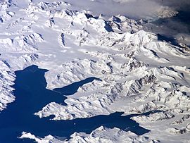
Cumberland Bay
Encyclopedia

Larsen Point
Larsen Point is a headland which forms the west side of the entrance to Cumberland Bay on the north coast of South Georgia. Named for Captain C.A. Larsen, who visited Cumberland Bay in the Jason in 1893-94....
and Barff
Barff Point
Barff Point is a headland which forms the east side of the entrance to Cumberland Bay, on the north coast of South Georgia. It was named for Lieutenant A.D. Barff, Royal Navy, of the Sappho, who, assisted by Captain C.A. Larsen, made a sketch map of Cumberland Bay in 1906....
Points, which separates into two extensive arms that recede inland 14 km (8.7 mi) along the northern coast of South Georgia
South Georgia and the South Sandwich Islands
South Georgia and the South Sandwich Islands is a British overseas territory and overseas territory of the European Union in the southern Atlantic Ocean. It is a remote and inhospitable collection of islands, consisting of South Georgia and a chain of smaller islands, known as the South Sandwich...
. Discovered and named in 1775 by a British expedition under James Cook
James Cook
Captain James Cook, FRS, RN was a British explorer, navigator and cartographer who ultimately rose to the rank of captain in the Royal Navy...
.
During the Second World War the whaling stations were closed excepting Grytviken
Grytviken
Grytviken is the principal settlement in the British territory of South Georgia in the South Atlantic. It was so named in 1902 by the Swedish surveyor Johan Gunnar Andersson who found old English try pots used to render seal oil at the site. It is the best harbour on the island, consisting of a...
and Leith Harbour
Leith Harbour
Leith Harbour , also known as Port Leith, was a whaling station up on the northeast coast of South Georgia, established and operated by Christian Salvesen Ltd, Edinburgh. The station was in operation from 1909 until 1965. It was the largest of seven whaling stations, situated near the mouth of...
. Most of the British and Norwegian
Norway
Norway , officially the Kingdom of Norway, is a Nordic unitary constitutional monarchy whose territory comprises the western portion of the Scandinavian Peninsula, Jan Mayen, and the Arctic archipelago of Svalbard and Bouvet Island. Norway has a total area of and a population of about 4.9 million...
whaling factories and catchers were destroyed by German
Nazi Germany
Nazi Germany , also known as the Third Reich , but officially called German Reich from 1933 to 1943 and Greater German Reich from 26 June 1943 onward, is the name commonly used to refer to the state of Germany from 1933 to 1945, when it was a totalitarian dictatorship ruled by...
raiders, while the rest were called up to serve under Allied command. The resident British Magistrates (W. Barlas and A.I. Fleuret) attended to the island’s defence throughout the War. The Royal Navy
Royal Navy
The Royal Navy is the naval warfare service branch of the British Armed Forces. Founded in the 16th century, it is the oldest service branch and is known as the Senior Service...
armed the merchant vessel Queen of Bermuda to patrol South Georgian and Antarctic waters, and deployed two four-inch guns at key locations protecting the approaches to Cumberland Bay and Stromness Bay
Stromness Bay
Stromness Bay is a bay wide, entered between Cape Saunders and Busen Point on the north coast of South Georgia.Stromness Bay, like Leith Harbour takes its name from a location in Scotland, Stromness, on the Orkney Mainland...
, i.e. to Grytviken and Leith Harbour respectively. These batteries (still present) were manned by volunteers from among the Norwegian whalers who were trained for the purpose.
Previous name of Guantánamo Bay
Guantánamo Bay in CubaCuba
The Republic of Cuba is an island nation in the Caribbean. The nation of Cuba consists of the main island of Cuba, the Isla de la Juventud, and several archipelagos. Havana is the largest city in Cuba and the country's capital. Santiago de Cuba is the second largest city...
also bore the name "Cumberland Bay" during part of the 18th Century, when for a time it was occupied and garrisoned by the British.
Cumberland Bay in the South Pacific
There is also a Cumberland Bay on Robinson Crusoe IslandRobinson Crusoe Island
Robinson Crusoe Island , formerly known as Más a Tierra , or Aguas Buenas, is the largest island of the Chilean Juan Fernández archipelago, situated 674 kilometres west of South America in the South Pacific Ocean...
.

