

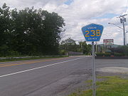
New York State Route 23
Encyclopedia
New York State Route 23 (NY 23) is an east–west state highway
in the eastern portion New York
in the United States. It extends for 156.15 miles (251.3 km) from an intersection with NY 26
in the Central New York
town of Cincinnatus
to the Massachusetts
state line in the Berkshire Mountains, where it continues east as that state's Route 23. Along the way, it passes through many communities, including the cities of Norwich
and Oneonta. Outside of the communities, the route serves largely rural areas of the state and traverses the Catskill Mountains
in the state's Central New York Region
. NY 23 crosses the Hudson River
at Catskill
via the Rip Van Winkle Bridge
.
Sections of what is now NY 23 were part of unsigned legislative route
s as early as 1908; however, NY 23 itself was not assigned until 1924. At the time, the route extended from Oneonta to Massachusetts and followed a slightly different alignment from Cairo
to Claverack
via Hudson
that took the route along modern County Route 23B (CR 23B) in eastern Greene County
. NY 23 was extended west to Norwich in the mid-1920s and to NY 26 in northwestern Chenango County
in 1930. The route was gradually moved onto its current alignment between Cairo and Claverack in the 1950s and 1960s, and realigned on its western end in 1984 to serve Cortland County
.
and the Central New York Region
(formerly Leatherstocking), the middle in the Catskills
, and east of the Hudson River
. Most of the route is maintained by the New York State Department of Transportation
(NYSDOT); however, some sections are either locally maintained or owned by other agencies. In the city of Norwich
, NY 23 is entirely city-owned and maintained. Farther east in the city of Oneonta, the route is city-maintained from the western city line to James F. Lettis Highway. Finally, the Rip Van Winkle Bridge
and its approaches are maintained by the New York State Bridge Authority
(NYSBA).
in Cincinnatus
, a town in eastern Cortland County
. It heads east across the Otselic River
and through the hamlet of Lower Cincinnatus before curving to the northeast and crossing into Chenango County
very soon afterward. Across the county line, it continues northeast through a lightly developed valley surrounding Brakel Creek to the Pharsalia State Wildlife Management Area, where it connects with CR 42, a highway that was once part of NY 23. From here, the route heads southeastward along another valley, this one surrounding Canasawacta Creek, to the city of Norwich
, the county seat
of Chenango County. It heads east–west across the city on Pleasant and Rexford Streets, passing through mostly residential areas and intersecting with NY 12
at Broad Street.
On the eastern fringe of Norwich, NY 23 passes over the Chenango River
and leaves the valley holding the river and the city, utilizing a gap in the valley wall formed by Ransford Creek. The waterway ends shortly afterward; however, the route continues on, winding its way eastward into the town of New Berlin
and the small hamlet of South New Berlin, situated in another valley surrounding the Unadilla River
. Here, it connects to NY 8
, another major north–south route. The route crosses the river just east of South New Berlin, putting it into the equally hilly and rural Otsego County
. After 6.5 miles (10.5 km) of isolated areas, NY 23 encounters the village of Morris
, the first of several villages along the route. In the village center, it briefly joins NY 51
along Morris' main street.
Beyond Morris, the route continues in an easterly direction with a generally southern trend through rolling farmland until its turns south again at the Laurens hamlet of West Laurens. A brief easterly turn 5 miles (8 km) later at West Oneonta takes it across Otego Creek to a junction with NY 205
on the eastern side of the creek's valley. NY 23 joins NY 205 here, and the two highways enter the western outskirts of the nearby city of Oneonta. At Chestnut Street, the first intersection that the route has in the city's vicinity, NY 23 leaves NY 205 to follow Chestnut Street. While NY 205 continues south toward the National Soccer Hall of Fame
, NY 23 heads east toward downtown Oneonta
. Just one block later, however, it meets NY 7
, which comes in from the southwest on Oneida Street. NY 7 turns east at this point to follow NY 23 into the city limits.
The two routes serve as Oneonta's main street, following Chestnut and Main Streets across the city's western and central areas. Along the way, NY 7 and NY 23 pass Hartwick College
and serve Oneonta's central business district. NY 23 breaks from NY 7 just northeast of downtown to follow James F. Lettis Highway, a four-lane divided highway
, south into the southern half of the city. As it heads south on the arterial, it connects to Interstate 88
(I-88) at an interchange on the northern bank of the Susquehanna River
. NY 28
—which overlaps with I-88 from Oneonta to exit 17 northeast of the city—leaves the freeway here, following NY 23 across the river to a large commercial district on the south bank. NY 28 leaves NY 23 here to proceed to the southwest while NY 23 goes eastward past several large strip mall
s and big-box retailers on its way out of both Oneonta and Otsego County.
, NY 23 initially follows a generally easterly routing through the Charlotte Creek valley. Here, the land gets more forested and the amount of houses decrease as it crosses the county. After Davenport
, a hamlet 8 miles (13 km) east of Oneonta, the road begins to climb onto the Catskill Plateau
. By the time it intersects NY 10
at the village of Stamford
, it has already reached an elevation of 1820 feet (555 m) above sea level. Not far to the east of the NY 10 junction, it crosses the West Branch
of the Delaware River
, by this point a small brook as the river's source
is located just 1 miles (1.6 km) to the north. It maintains this elevation during a brief, 2.5 miles (4 km) foray into Schoharie County
that leads the route around a pair of 3000 feet (914 m) mountains situated south of the county line.
Elevation drops slightly upon reaching the hamlet of Grand Gorge within the town of Roxbury
, located just above a small pond alongside NY 30
that gives rise to the Delaware's East Branch
. NY 23 intersects NY 30 in the hamlet's center before making a sharp bend to the south as it approaches the Schoharie Reservoir
, located 3 miles (5 km) southeast of Grand Gorge. The route passes by the reservoir's southern tip before it enters Greene County
and the town of Prattsville
. Just inside the county, a bridge carries the highway over Schoharie Creek
and into the next community, the hamlet of Prattsville. Pratt Rock
, a series of rock carvings depicting the life of Zadock Pratt—the tanner
and politician
who lent his name to the town—is located just east of the hamlet.
Southeast of Prattsville hamlet, NY 23A
splits off from NY 23 to continue along Schoharie Creek while the latter climbs in elevation again along Batavia Kill. Shortly past Red Falls, all crossings of the creek come to mark the Blue Line
that delineates the Catskill Park. The route remains to the north of the creek even as it passes the Windham Mountain
ski area and NY 296
comes in from the south. However, it crosses it several times and is within the park as it reaches its highest point, 1940 feet (591 m) at the pass
next to Windham High Peak
where the Long Path
crosses the road. From here, NY 23 begins a long descent down the Catskill Escarpment
, losing most of the elevation it had gained since leaving Oneonta. As it does so, the route provides sweeping, panoramic views of the Capital District
and points north, east and west. Along this stretch is Five State Lookout, a vista providing views of five states and four mountain ranges, including the Adirondack foothills and Green Mountains
in Vermont
.
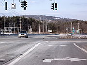
Having reached the floor of the Hudson Valley
, NY 23 assumes a southeast-trending route through the town of Cairo
. It comes close to the hamlet of Cairo
, but bypasses it on a four-lane divided highway that takes it around the northern fringe of the community. As it runs around Cairo, the route connects to NY 145
and briefly overlaps NY 32
, the major north–south state route on the west side of the Hudson River
. NY 23 continues as a divided highway through mostly forested areas to the town of Catskill
, where it crosses Catskill Creek
and has an indirect intersection with the New York State Thruway
(I-87
). Not far to the southeast is the village of Catskill
, the county seat of Greene County. NY 23 bypasses this community as well, connecting to U.S. Route 9W (US 9W) and NY 385
at junctions in lightly populated areas north of the village prior to crossing the Hudson River on the Rip Van Winkle Bridge
.
 Once across the bridge and into Columbia County
, the highway encounters NY 9G
near the Olana State Historic Site
in western Greenport
. The two highways briefly overlap until NY 9G continues north with NY 23B
to follow NY 23's old course into and through the city of Hudson
. NY 23 continues to the southeast, bypassing Hudson well to the south and serving Columbia–Greene Community College, located in an otherwise forested area of Greenport. After 2 miles (3.2 km) miles, the route meets US 9 at an isolated junction due south of Hudson. US 9 and NY 23 overlap for 2.5 miles (4 km) across more open but still largely undeveloped areas to a small, unnamed community on the western edge of Bell Pond, a small waterbody in the northeast corner of the town of Livingston
.
In the center of the hamlet, US 9 and NY 23 encounter a complex intersection that features a total of four routes. At the junction, US 9 continues to the southwest while NY 82
continues southeast along NY 23's course. NY 23, meanwhile, picks up US 9's routing, overlapping with NY 9H
in a northerly direction that takes both highways across Taghkanic Creek
and into the equally rural town of Claverack
. The routes remain overlapped into the hamlet of Claverack, where NY 23B comes in from the west and finishes its alternate loop of NY 23. At the same junction, NY 23 leaves the north–south NY 9H to resume an east–west alignment toward the Massachusetts
state line.
Shortly after the NY 9H junction, NY 217
splits off to the northeast toward Philmont
. The road continues southeastward from NY 217, crossing over Claverack Creek
and leaving the built-up hamlet of Claverack for countryside more open and less rugged than that in the Catskills. It proceeds generally easterly across mostly undeveloped fields to Martindale, a small community at the interchange linking NY 23 to the Taconic State Parkway
. From here, NY 23 follows a creek valley southeast and east into Hillsdale
, where the route connects to NY 22
, a north–south highway that closely parallels New York's eastern state line for most of its length. Almost 3 miles (5 km) to the east, NY 23 reaches the state line, where it becomes Massachusetts Route 23 as it serves the bi-state Catamount Ski Area
.
that extended from Kingston in the south to Mohawk
in the north. From Oneonta to Grand Gorge
, Route 5 utilized modern NY 23. The portion of what is now NY 23 from Grand Gorge to Prattsville was designated as part of Route 38 in 1909 while the segment between the Delaware
–Greene
County line and Catskill
(via modern CR 23B) became Route 5-a in 1911. On March 1, 1921, Route 38 was realigned to enter Grand Gorge from the northeast on modern NY 30
while Route 5-a was renumbered to Route 47 and extended northwest to Grand Gorge over the former routing of Route 38.
When the first set of posted routes in New York were assigned in 1924, the Oneonta–Grand Gorge segment of legislative Route 5 and all of Route 47 became part of NY 23, which continued east from Catskill to the Massachusetts
state line southwest of Great Barrington, Massachusetts
. It initially overlapped with NY 10
(later US 9W
) northward along modern NY 385
to Athens
, where it crossed the Hudson River
via a ferry
to Hudson
. It continued east from Hudson on what is now NY 23B
to Claverack
, where it joined its modern alignment to Massachusetts. NY 23 was extended westward to NY 12
in Norwich
in the mid-1920s. In the 1930 renumbering of state highways in New York, NY 23 was extended west along a previously unnumbered roadway to NY 26
in northwest Chenango County
. From Norwich to North Pharsalia, NY 23 followed its modern alignment; between North Pharsalia and NY 26, NY 23 was routed on modern CR 42.
over the Hudson River between Catskill and Greenport
was opened to traffic. It became part of a realigned NY 23 after the Athens–Hudson ferry shut down in the late 1940s. NY 23 utilized modern NY 23B between the bridge and Hudson. Plans were made in the early 1950s to construct a southern bypass of the city of Hudson between the Rip Van Winkle Bridge and NY 23 midway between Claverack and Hollowville. Construction on the portion of the highway between the bridge and US 9 south of Hudson began in the mid-1950s and was completed in the late 1950s as a realignment of NY 23. Ultimately, this was the only section that was built; as a result, NY 23 overlapped with US 9 and NY 9H
to reach its former alignment in Claverack.
 Ca. 1940, NY 145
was extended eastward along NY 23 from Cairo
to Catskill. Both routes were realigned in the 1960s to follow a new arterial between Cairo and the Rip Van Winkle Bridge in Catskill. The first segment of the highway, a northerly bypass of the hamlet of Cairo, opened ca. 1961. The remainder of the arterial was completed in the mid-1960s. NY 145 was truncated back to Cairo on January 1, 1970. Much of NY 23's former routing between Cairo and the Catskill village line is now CR 23B; however, a 0.63 miles (1.01 km) segment in Jefferson Heights
between exit 21 of the New York State Thruway
and a town road named Austin Acres is state-maintained as NY 911V, an unsigned reference route.
In July 1984, NY 23 was realigned west of North Pharsalia to follow a new highway between NY 26 in Cincinnatus
and North Pharsalia. The length of the Chenango County
portion of the new alignment was 8.4 miles (13.52 km), roughly double that of NY 23's old routing (4.39 miles or 7.07 km). The 8.5 miles (13.7 km) of state highway mileage for the new road in Chenango County came from NY 23's former routing and NY 319
near Norwich, both of which were transferred to Chenango County after the new highway was completed.
|rowspan=2 colspan=2 style="text-align:center"|Rip Van Winkle Bridge
over the Hudson River
|-
|rowspan=10|Columbia
|rowspan=4|Greenport
State highway
State highway, state road or state route can refer to one of three related concepts, two of them related to a state or provincial government in a country that is divided into states or provinces :#A...
in the eastern portion New York
New York
New York is a state in the Northeastern region of the United States. It is the nation's third most populous state. New York is bordered by New Jersey and Pennsylvania to the south, and by Connecticut, Massachusetts and Vermont to the east...
in the United States. It extends for 156.15 miles (251.3 km) from an intersection with NY 26
New York State Route 26
New York State Route 26 is a north–south state highway that runs for through Central New York in the United States. Its southern terminus is located at the Pennsylvania state line south of the town of Vestal in Broome County, where it becomes Pennsylvania Route 267...
in the Central New York
Central New York
Central New York is a term used to broadly describe the central region of New York State, roughly including the following counties and cities:...
town of Cincinnatus
Cincinnatus, New York
Cincinnatus is a town in Cortland County, New York, U.S. The population was 1,051 at the 2000 census. The town is named after an important Roman general, Cincinnatus....
to the Massachusetts
Massachusetts
The Commonwealth of Massachusetts is a state in the New England region of the northeastern United States of America. It is bordered by Rhode Island and Connecticut to the south, New York to the west, and Vermont and New Hampshire to the north; at its east lies the Atlantic Ocean. As of the 2010...
state line in the Berkshire Mountains, where it continues east as that state's Route 23. Along the way, it passes through many communities, including the cities of Norwich
Norwich (city), New York
Norwich is a city in Chenango County, New York, United States. Surrounded on all sides by the Town of Norwich, the city is the county seat of Chenango County. The name is taken from Norwich, Connecticut. Its population was 7,355 at the 2000 census.Lt...
and Oneonta. Outside of the communities, the route serves largely rural areas of the state and traverses the Catskill Mountains
Catskill Mountains
The Catskill Mountains, an area in New York State northwest of New York City and southwest of Albany, are a mature dissected plateau, an uplifted region that was subsequently eroded into sharp relief. They are an eastward continuation, and the highest representation, of the Allegheny Plateau...
in the state's Central New York Region
Central New York Region
The Central New York Region is a term used by the New York State Department of Economic Development to broadly describe the central region of New York State for tourism purposes. The region roughly corresponds to the upper Susquehanna and Mohawk Valleys...
. NY 23 crosses the Hudson River
Hudson River
The Hudson is a river that flows from north to south through eastern New York. The highest official source is at Lake Tear of the Clouds, on the slopes of Mount Marcy in the Adirondack Mountains. The river itself officially begins in Henderson Lake in Newcomb, New York...
at Catskill
Catskill (village), New York
Catskill is a village in Greene County, New York, USA. The population was 4,081 at the 2010 census.The Village of Catskill is in the northeast part of the Town of Catskill. Catskill is the county seat of Greene County.-History:...
via the Rip Van Winkle Bridge
Rip Van Winkle Bridge
The Rip Van Winkle Bridge is a cantilever bridge spanning the Hudson River between Hudson, NY and Catskill, New York. The structure carries NY 23 across the river, connecting on the west side, US 9W and NY 385 with NY 9G on the east side. The bridge was built by the newly created New York State...
.
Sections of what is now NY 23 were part of unsigned legislative route
Legislative route
In United States, a legislative route or legislative highway is a highway defined by laws passed in a state legislature. The numbering of such highways may or may not correspond to the numbers familiar to the public as part of the state, U.S. highway, and Interstate highway systems...
s as early as 1908; however, NY 23 itself was not assigned until 1924. At the time, the route extended from Oneonta to Massachusetts and followed a slightly different alignment from Cairo
Cairo (CDP), New York
Cairo is a census-designated place in the town of Cairo in Greene County, New York, United States. The population was 1,390 at the 2000 census.-Geography:Cairo is located at ....
to Claverack
Claverack, New York
Claverack is a town in Columbia County, New York, United States. The population was 6,401 at the 2000 census. The town name is a corruption for the Dutch word for "Clover Fields" or "Clover Reach"....
via Hudson
Hudson, New York
Hudson is a city located along the west border of Columbia County, New York, United States. The city is named after the adjacent Hudson River and ultimately after the explorer Henry Hudson.Hudson is the county seat of Columbia County...
that took the route along modern County Route 23B (CR 23B) in eastern Greene County
Greene County, New York
Greene County is a county located in the U.S. state of New York. Its name is in honor of the American Revolutionary War general Nathanael Greene. Its county seat is Catskill...
. NY 23 was extended west to Norwich in the mid-1920s and to NY 26 in northwestern Chenango County
Chenango County, New York
Chenango County is a county located in the U.S. state of New York. As of the 2010 census, the population was 50,477. The county's name originates from an Oneida word meaning "large bull-thistle." Its county seat is Norwich.-History:...
in 1930. The route was gradually moved onto its current alignment between Cairo and Claverack in the 1950s and 1960s, and realigned on its western end in 1984 to serve Cortland County
Cortland County, New York
Cortland County is a county located in the U.S. state of New York, named after Federico Van Cortlandt, president of the convention at Kingston that wrote the first New York State Constitution in 1777, and first lieutenant governor of the state. The county seat is Cortland...
.
Route description
NY 23 has three distinct sections: its western third in Central New YorkCentral New York
Central New York is a term used to broadly describe the central region of New York State, roughly including the following counties and cities:...
and the Central New York Region
Central New York Region
The Central New York Region is a term used by the New York State Department of Economic Development to broadly describe the central region of New York State for tourism purposes. The region roughly corresponds to the upper Susquehanna and Mohawk Valleys...
(formerly Leatherstocking), the middle in the Catskills
Catskill Mountains
The Catskill Mountains, an area in New York State northwest of New York City and southwest of Albany, are a mature dissected plateau, an uplifted region that was subsequently eroded into sharp relief. They are an eastward continuation, and the highest representation, of the Allegheny Plateau...
, and east of the Hudson River
Hudson River
The Hudson is a river that flows from north to south through eastern New York. The highest official source is at Lake Tear of the Clouds, on the slopes of Mount Marcy in the Adirondack Mountains. The river itself officially begins in Henderson Lake in Newcomb, New York...
. Most of the route is maintained by the New York State Department of Transportation
New York State Department of Transportation
The New York State Department of Transportation is responsible for the development and operation of highways, railroads, mass transit systems, ports, waterways and aviation facilities in the U.S...
(NYSDOT); however, some sections are either locally maintained or owned by other agencies. In the city of Norwich
Norwich (city), New York
Norwich is a city in Chenango County, New York, United States. Surrounded on all sides by the Town of Norwich, the city is the county seat of Chenango County. The name is taken from Norwich, Connecticut. Its population was 7,355 at the 2000 census.Lt...
, NY 23 is entirely city-owned and maintained. Farther east in the city of Oneonta, the route is city-maintained from the western city line to James F. Lettis Highway. Finally, the Rip Van Winkle Bridge
Rip Van Winkle Bridge
The Rip Van Winkle Bridge is a cantilever bridge spanning the Hudson River between Hudson, NY and Catskill, New York. The structure carries NY 23 across the river, connecting on the west side, US 9W and NY 385 with NY 9G on the east side. The bridge was built by the newly created New York State...
and its approaches are maintained by the New York State Bridge Authority
New York State Bridge Authority
The New York State Bridge Authority is a public benefit corporation in New York State, United States. The NYSBA was born out of the necessity for a bridge over the Hudson River to link the city of Hudson and the village of Catskill.-History:...
(NYSBA).
Central New York
The highway begins at a junction with NY 26New York State Route 26
New York State Route 26 is a north–south state highway that runs for through Central New York in the United States. Its southern terminus is located at the Pennsylvania state line south of the town of Vestal in Broome County, where it becomes Pennsylvania Route 267...
in Cincinnatus
Cincinnatus, New York
Cincinnatus is a town in Cortland County, New York, U.S. The population was 1,051 at the 2000 census. The town is named after an important Roman general, Cincinnatus....
, a town in eastern Cortland County
Cortland County, New York
Cortland County is a county located in the U.S. state of New York, named after Federico Van Cortlandt, president of the convention at Kingston that wrote the first New York State Constitution in 1777, and first lieutenant governor of the state. The county seat is Cortland...
. It heads east across the Otselic River
Otselic River
The Otselic River is a tributary of the Tioughnioga River in central New York in the United States. It drains a mountainous area, mostly forested and agricultural, east of the Finger Lakes at the northern edge of the Susquehanna River watershed....
and through the hamlet of Lower Cincinnatus before curving to the northeast and crossing into Chenango County
Chenango County, New York
Chenango County is a county located in the U.S. state of New York. As of the 2010 census, the population was 50,477. The county's name originates from an Oneida word meaning "large bull-thistle." Its county seat is Norwich.-History:...
very soon afterward. Across the county line, it continues northeast through a lightly developed valley surrounding Brakel Creek to the Pharsalia State Wildlife Management Area, where it connects with CR 42, a highway that was once part of NY 23. From here, the route heads southeastward along another valley, this one surrounding Canasawacta Creek, to the city of Norwich
Norwich (city), New York
Norwich is a city in Chenango County, New York, United States. Surrounded on all sides by the Town of Norwich, the city is the county seat of Chenango County. The name is taken from Norwich, Connecticut. Its population was 7,355 at the 2000 census.Lt...
, the county seat
County seat
A county seat is an administrative center, or seat of government, for a county or civil parish. The term is primarily used in the United States....
of Chenango County. It heads east–west across the city on Pleasant and Rexford Streets, passing through mostly residential areas and intersecting with NY 12
New York State Route 12
New York State Route 12 is a state highway extending for through central and northern New York in the United States. The southern terminus of the route is at U.S. Route 11 in the town of Chenango in the Southern Tier. The northern terminus is at NY 37 near the village of...
at Broad Street.
On the eastern fringe of Norwich, NY 23 passes over the Chenango River
Chenango River
The Chenango River is a tributary of the Susquehanna River in central New York in the United States. It drains a dissected plateau area in upstate New York at the northern end of the Susquehanna watershed....
and leaves the valley holding the river and the city, utilizing a gap in the valley wall formed by Ransford Creek. The waterway ends shortly afterward; however, the route continues on, winding its way eastward into the town of New Berlin
New Berlin (town), New York
New Berlin is a town in Chenango County, New York, United States. The population was 2,803 at the 2000 census.The Town of New Berlin contains a village named New Berlin...
and the small hamlet of South New Berlin, situated in another valley surrounding the Unadilla River
Unadilla River
The Unadilla River in New York State flows from south of Utica to the village of Sidney, where it flows into the Susquehanna River, which eventually empties into the Chesapeake Bay, an arm of the Atlantic Ocean....
. Here, it connects to NY 8
New York State Route 8
New York State Route 8 is a state highway in the central part of New York in the United States. It runs in a southwest-to-northeast direction from the Southern Tier to the northern part of Lake George. The southern terminus of the route is at an interchange with NY 17 in the town of...
, another major north–south route. The route crosses the river just east of South New Berlin, putting it into the equally hilly and rural Otsego County
Otsego County, New York
Otsego County is a county located in the U.S. state of New York. The 2010 population was 62,259. The county seat is Cooperstown. The name Otsego is from a Mohawk word meaning "place of the rock."-History:...
. After 6.5 miles (10.5 km) of isolated areas, NY 23 encounters the village of Morris
Morris (village), New York
Morris is a village in Otsego County, New York, United States. The population was 591 at the 2000 census.The Village of Morris is centrally located in the Town of Morris and is northwest of the City of Oneonta.- History :...
, the first of several villages along the route. In the village center, it briefly joins NY 51
New York State Route 51
New York State Route 51 is a state highway in the central part of New York state. The highway runs generally in a southwest to northeast direction from the hamlet of Mount Upton to the village of Ilion...
along Morris' main street.
Beyond Morris, the route continues in an easterly direction with a generally southern trend through rolling farmland until its turns south again at the Laurens hamlet of West Laurens. A brief easterly turn 5 miles (8 km) later at West Oneonta takes it across Otego Creek to a junction with NY 205
New York State Route 205
New York State Route 205 is a state highway in New York, running from near the city of Oneonta to the town of Otsego in Otsego County. NY 205 is a two-lane highway its entire length and passes through Hartwick....
on the eastern side of the creek's valley. NY 23 joins NY 205 here, and the two highways enter the western outskirts of the nearby city of Oneonta. At Chestnut Street, the first intersection that the route has in the city's vicinity, NY 23 leaves NY 205 to follow Chestnut Street. While NY 205 continues south toward the National Soccer Hall of Fame
National Soccer Hall of Fame
The National Soccer Hall of Fame is a private, non-profit institution established in 1979 that honors soccer achievements in the United States.-History:...
, NY 23 heads east toward downtown Oneonta
Oneonta Downtown Historic District
Oneonta Downtown Historic District is a national historic district located at Oneonta in Otsego County, New York. It encompasses 64 contributing buildings and one contributing site. It encompasses the city's intact commercial and civic core and includes commercial buildings, six churches, the...
. Just one block later, however, it meets NY 7
New York State Route 7
New York State Route 7 is a 180-mile long New York State Highway that runs from the New York/Pennsylvania border south of Binghamton, New York to the New York/Vermont border east of Hoosick. Most of the road runs along the Susquehanna Valley, closely paralleling Interstate 88 throughout...
, which comes in from the southwest on Oneida Street. NY 7 turns east at this point to follow NY 23 into the city limits.
The two routes serve as Oneonta's main street, following Chestnut and Main Streets across the city's western and central areas. Along the way, NY 7 and NY 23 pass Hartwick College
Hartwick College
Hartwick College is a non-denominational, private, four-year liberal arts and sciences college located in Oneonta, New York, in the United States. The institution was founded as Hartwick Seminary in 1797 through the will of John Christopher Hartwick, and is now known as Hartwick College...
and serve Oneonta's central business district. NY 23 breaks from NY 7 just northeast of downtown to follow James F. Lettis Highway, a four-lane divided highway
Divided Highway
Divided Highway is a compilation album by American rock band The Doobie Brothers, released in 2003. . All tracks are taken from the albums Cycles and Brotherhood .-Track listing:...
, south into the southern half of the city. As it heads south on the arterial, it connects to Interstate 88
Interstate 88 (east)
Interstate 88 is an intrastate Interstate Highway entirely within the U.S. state of New York. Its western end is at Interstate 81 in Binghamton and its eastern end is at Interstate 90 in Schenectady. It serves as an important connector route from Albany to Binghamton, Elmira , and...
(I-88) at an interchange on the northern bank of the Susquehanna River
Susquehanna River
The Susquehanna River is a river located in the northeastern United States. At long, it is the longest river on the American east coast that drains into the Atlantic Ocean, and with its watershed it is the 16th largest river in the United States, and the longest river in the continental United...
. NY 28
New York State Route 28
New York State Route 28 is a state highway extending for in the shape of a "C" between the Hudson Valley city of Kingston and southern Warren County in the U.S. state of New York. Along the way, it intersects several major routes, including Interstate 88 , U.S. Route 20 , and the...
—which overlaps with I-88 from Oneonta to exit 17 northeast of the city—leaves the freeway here, following NY 23 across the river to a large commercial district on the south bank. NY 28 leaves NY 23 here to proceed to the southwest while NY 23 goes eastward past several large strip mall
Strip mall
A strip mall is an open-area shopping center where the stores are arranged in a row, with a sidewalk in front. Strip malls are typically developed as a unit and have large parking lots in front...
s and big-box retailers on its way out of both Oneonta and Otsego County.
Catskills
In the adjacent Delaware CountyDelaware County, New York
Delaware County is a county located in the U.S. state of New York. As of 2010 the population was 47,980. The county seat is Delhi. It is named after the Delaware River, which was named in honor of Thomas West, 3rd Baron De La Warr, appointed governor of Virginia in 1609.-History:When counties...
, NY 23 initially follows a generally easterly routing through the Charlotte Creek valley. Here, the land gets more forested and the amount of houses decrease as it crosses the county. After Davenport
Davenport, New York
Davenport is a town in Delaware County, New York, USA. The population was 2,774 at the 2000 census.The Town of Davenport is in the northeast part of the county.- History :...
, a hamlet 8 miles (13 km) east of Oneonta, the road begins to climb onto the Catskill Plateau
Catskill Mountains
The Catskill Mountains, an area in New York State northwest of New York City and southwest of Albany, are a mature dissected plateau, an uplifted region that was subsequently eroded into sharp relief. They are an eastward continuation, and the highest representation, of the Allegheny Plateau...
. By the time it intersects NY 10
New York State Route 10
New York State Route 10 is a north–south state highway in the Central New York and North Country regions of New York in the United States. It extends for from the Quickway in Deposit, Delaware County to NY 8 at Higgins Bay, a hamlet in the Hamilton County town of Arietta...
at the village of Stamford
Stamford (village), New York
Stamford is a village in Delaware County, New York, United States. The population was 1,265 at the 2000 census.The Village of Stamford is located partly in the Town of Stamford and partly in the Town of Harpersfield. The village is on routes 23 and 10...
, it has already reached an elevation of 1820 feet (555 m) above sea level. Not far to the east of the NY 10 junction, it crosses the West Branch
West Branch Delaware River
The West Branch Delaware River, approximately 90 mi long in the U.S. states of New York and Pennsylvania, is one of the two branches, along with the East Branch, that join to form the Delaware River...
of the Delaware River
Delaware River
The Delaware River is a major river on the Atlantic coast of the United States.A Dutch expedition led by Henry Hudson in 1609 first mapped the river. The river was christened the South River in the New Netherland colony that followed, in contrast to the North River, as the Hudson River was then...
, by this point a small brook as the river's source
Source (river or stream)
The source or headwaters of a river or stream is the place from which the water in the river or stream originates.-Definition:There is no universally agreed upon definition for determining a stream's source...
is located just 1 miles (1.6 km) to the north. It maintains this elevation during a brief, 2.5 miles (4 km) foray into Schoharie County
Schoharie County, New York
As of the census of 2000, there were 31,582 people, 11,991 households and 8,177 families residing in the county. The population density was 51 people per square mile . There were 15,915 housing units at an average density of 26 per square mile...
that leads the route around a pair of 3000 feet (914 m) mountains situated south of the county line.
Elevation drops slightly upon reaching the hamlet of Grand Gorge within the town of Roxbury
Roxbury, New York
Roxbury is a town in Delaware County, New York, United States. The population was 2,509 at the 2000 census.The Town of Roxbury is at the eastern end of the county.- History :...
, located just above a small pond alongside NY 30
New York State Route 30
New York State Route 30 is a state highway in the central part of New York in the United States. It extends for from an interchange with NY 17 in the Southern Tier to the Canadian border in the state's North Country, where it continues into Quebec as Route 138. On a regional level,...
that gives rise to the Delaware's East Branch
East Branch Delaware River
The East Branch Delaware River, approximately 75 miles long in the U.S. state of New York, is one of two branches, along with the West Branch, that join to form the Delaware River. It flows through a mountainous area on the southwestern edge of the Catskill Park. For a long stretch it serves...
. NY 23 intersects NY 30 in the hamlet's center before making a sharp bend to the south as it approaches the Schoharie Reservoir
Schoharie Reservoir
The Schoharie Reservoir is a small reservoir in the Catskill Mountains of New York State that was created to be one of 19 reservoirs that supplies New York City with water. It was created by impounding Schoharie Creek...
, located 3 miles (5 km) southeast of Grand Gorge. The route passes by the reservoir's southern tip before it enters Greene County
Greene County, New York
Greene County is a county located in the U.S. state of New York. Its name is in honor of the American Revolutionary War general Nathanael Greene. Its county seat is Catskill...
and the town of Prattsville
Prattsville, New York
Prattsville is a town in Greene County, New York, United States. The Town of Prattsville is in the northwest part of the county. As of the 2010 census, the city population was 700.- History :...
. Just inside the county, a bridge carries the highway over Schoharie Creek
Schoharie Creek
Schoharie Creek in New York, USA flows north from the foot of Indian Head Mountain in the Catskill Mountains through the Schoharie Valley to the Mohawk River. It is twice impounded north of Prattsville to create New York City's Schoharie Reservoir and the Blenheim-Gilboa Power Project.Two notable...
and into the next community, the hamlet of Prattsville. Pratt Rock
Pratt Rock
Pratt Rock, also known as Pratt's Rock, is a rockface or other landform that includes a series of stone carvings in Prattsville, New York depicting the life of Zadock Pratt...
, a series of rock carvings depicting the life of Zadock Pratt—the tanner
Tanning
Tanning is the making of leather from the skins of animals which does not easily decompose. Traditionally, tanning used tannin, an acidic chemical compound from which the tanning process draws its name . Coloring may occur during tanning...
and politician
Politician
A politician, political leader, or political figure is an individual who is involved in influencing public policy and decision making...
who lent his name to the town—is located just east of the hamlet.
Southeast of Prattsville hamlet, NY 23A
New York State Route 23A
New York State Route 23A is an east–west state highway in Greene County, New York, in the United States. It serves as a alternate route of NY 23 through the northern Catskill Mountains...
splits off from NY 23 to continue along Schoharie Creek while the latter climbs in elevation again along Batavia Kill. Shortly past Red Falls, all crossings of the creek come to mark the Blue Line
Blue Line (New York State)
The Blue Line is the term used in New York state for the boundaries of the Adirondack and Catskill parks, within which can be found the state's Forest Preserve...
that delineates the Catskill Park. The route remains to the north of the creek even as it passes the Windham Mountain
Windham Mountain
Windham Mountain is a ski resort located in the town of Windham, New York, in the northern section of the Catskill Mountains. It has 46 trails and 9 lifts, including two high-speed detachable quads, one from the bottom to top of each peak. The highest peak is situated at with a vertical rise of ...
ski area and NY 296
New York State Route 296
New York State Route 296 is a short state highway located entirely within both the Catskill Park and Greene County. It connects NY 23A in the village of Hunter with NY 23 near the Windham hamlet of Hensonville....
comes in from the south. However, it crosses it several times and is within the park as it reaches its highest point, 1940 feet (591 m) at the pass
Mountain pass
A mountain pass is a route through a mountain range or over a ridge. If following the lowest possible route, a pass is locally the highest point on that route...
next to Windham High Peak
Windham High Peak
Windham High Peak is a mountain located in Greene County, New York.The mountain is part of the Catskill Mountains.Windham High Peak stands within the watershed of the Hudson River, which drains into New York Bay....
where the Long Path
Long Path
The Long Path is a long-distance hiking trail beginning at the George Washington Bridge in Fort Lee, New Jersey and currently ending at Altamont, New York, in the Albany area...
crosses the road. From here, NY 23 begins a long descent down the Catskill Escarpment
Catskill Escarpment
The Catskill Escarpment, often referred to locally as just the Escarpment or the Great Wall of Manitou, and known as the Catskill Front to geologists, is the range forming the northeastern corner of the Catskill Mountains in Greene and Ulster counties in the U.S. state of New York...
, losing most of the elevation it had gained since leaving Oneonta. As it does so, the route provides sweeping, panoramic views of the Capital District
Capital District
New York's Capital District, also known as the Capital Region, is a region in upstate New York that generally refers to the four counties surrounding Albany, the capital of the state: Albany County, Schenectady County, Rensselaer County, and Saratoga County...
and points north, east and west. Along this stretch is Five State Lookout, a vista providing views of five states and four mountain ranges, including the Adirondack foothills and Green Mountains
Green Mountains
The Green Mountains are a mountain range in the U.S. state of Vermont. The range extends approximately .-Peaks:The most notable mountains in the range include:*Mount Mansfield, , the highest point in Vermont*Killington Peak, *Mount Ellen,...
in Vermont
Vermont
Vermont is a state in the New England region of the northeastern United States of America. The state ranks 43rd in land area, , and 45th in total area. Its population according to the 2010 census, 630,337, is the second smallest in the country, larger only than Wyoming. It is the only New England...
.
Having reached the floor of the Hudson Valley
Hudson Valley
The Hudson Valley comprises the valley of the Hudson River and its adjacent communities in New York State, United States, from northern Westchester County northward to the cities of Albany and Troy.-History:...
, NY 23 assumes a southeast-trending route through the town of Cairo
Cairo (town), New York
Cairo is a town in Greene County, New York, United States. The population was 6,610 at the 2010 census. The town is in the south part of the county, partly in the Catskill Park. Cairo is named after Cairo in Egypt, but is pronounced "Care-o" .- History :...
. It comes close to the hamlet of Cairo
Cairo (CDP), New York
Cairo is a census-designated place in the town of Cairo in Greene County, New York, United States. The population was 1,390 at the 2000 census.-Geography:Cairo is located at ....
, but bypasses it on a four-lane divided highway that takes it around the northern fringe of the community. As it runs around Cairo, the route connects to NY 145
New York State Route 145
New York State Route 145 is a state highway in eastern New York in the United States. The highway extends for from NY 23 in the Greene County town of Cairo to U.S. Route 20 in the Schoharie County town of Sharon. Along the way, NY 145 intersects NY 30 in Middleburgh and...
and briefly overlaps NY 32
New York State Route 32
New York State Route 32 is a north–south state highway that extends for through the Hudson Valley and Capital District regions of the U.S. state of New York. It is a two-lane surface road for nearly its entire length, with few divided and no limited-access sections. From Harriman to Albany,...
, the major north–south state route on the west side of the Hudson River
Hudson River
The Hudson is a river that flows from north to south through eastern New York. The highest official source is at Lake Tear of the Clouds, on the slopes of Mount Marcy in the Adirondack Mountains. The river itself officially begins in Henderson Lake in Newcomb, New York...
. NY 23 continues as a divided highway through mostly forested areas to the town of Catskill
Catskill (town), New York
Catskill is a town in the southeast part of Greene County, New York, United States. The population was 11,775 at the 2010 census. The western part of the town is in the Catskill Park....
, where it crosses Catskill Creek
Catskill Creek
Catskill Creek is a tributary of the Hudson River that drains the east northern Catskill Mountains of the U.S. state of New York. From its source at Franklinton Vlaie in Schoharie County it flows southeast through parts of Albany County and Greene County to its mouth at the village of Catskill on...
and has an indirect intersection with the New York State Thruway
New York State Thruway
The New York State Thruway is a system of limited-access highways located within the state of New York in the United States. The system, known officially as the Governor Thomas E. Dewey Thruway for former New York Governor Thomas E. Dewey, is operated by the New York State Thruway Authority and...
(I-87
Interstate 87
Interstate 87 is a Interstate Highway located entirely within New York State in the United States of America. I-87 is the longest intrastate Interstate highway in the Interstate Highway System. Its southern end is at the Bronx approaches of the Robert F. Kennedy Bridge in New York City...
). Not far to the southeast is the village of Catskill
Catskill (village), New York
Catskill is a village in Greene County, New York, USA. The population was 4,081 at the 2010 census.The Village of Catskill is in the northeast part of the Town of Catskill. Catskill is the county seat of Greene County.-History:...
, the county seat of Greene County. NY 23 bypasses this community as well, connecting to U.S. Route 9W (US 9W) and NY 385
New York State Route 385
New York State Route 385 is a state highway in Greene County, New York, United States. It runs from the village of Catskill to the village of Coxsackie, serving as an alternate route of U.S. Route 9W between the two locations. While US 9W follows a more inland routing, NY 385...
at junctions in lightly populated areas north of the village prior to crossing the Hudson River on the Rip Van Winkle Bridge
Rip Van Winkle Bridge
The Rip Van Winkle Bridge is a cantilever bridge spanning the Hudson River between Hudson, NY and Catskill, New York. The structure carries NY 23 across the river, connecting on the west side, US 9W and NY 385 with NY 9G on the east side. The bridge was built by the newly created New York State...
.
East of the Hudson
Columbia County, New York
Columbia County is a county located in the U.S. state of New York. As of the 2010 census, the population was 63,096. The county seat is Hudson. The name comes from the Latin feminine form of the name of Christopher Columbus, which was at the time of the formation of the county a popular proposal...
, the highway encounters NY 9G
New York State Route 9G
New York State Route 9G is a state highway in the Hudson Valley of New York in the United States. It runs north from U.S. Route 9 at Poughkeepsie, starting out as Violet Avenue, then follows the Hudson River mostly along the eastern side of the US 9 to Rhinebeck, where the two...
near the Olana State Historic Site
Olana State Historic Site
Olana State Historic Site was the home of Frederic Edwin Church , one of the major figures in the Hudson River School of landscape painting. The centerpiece of Olana is an eclectic villa composed of many styles, difficult to categorize, which overlooks parkland and a working farm designed by the...
in western Greenport
Greenport, Columbia County, New York
Greenport is a town in Columbia County, New York, United States. The population was 4,180 at the 2000 census.The Town of Greenport is on the west border of the county and surrounds the City of Hudson on three sides. US 9 passes through the town....
. The two highways briefly overlap until NY 9G continues north with NY 23B
New York State Route 23B
New York State Route 23B is an east–west state highway located in western Columbia County, New York, in the United States. The route is a former section of NY 23 that runs for from NY 9G southwest of Hudson to NY 9H in Claverack...
to follow NY 23's old course into and through the city of Hudson
Hudson, New York
Hudson is a city located along the west border of Columbia County, New York, United States. The city is named after the adjacent Hudson River and ultimately after the explorer Henry Hudson.Hudson is the county seat of Columbia County...
. NY 23 continues to the southeast, bypassing Hudson well to the south and serving Columbia–Greene Community College, located in an otherwise forested area of Greenport. After 2 miles (3.2 km) miles, the route meets US 9 at an isolated junction due south of Hudson. US 9 and NY 23 overlap for 2.5 miles (4 km) across more open but still largely undeveloped areas to a small, unnamed community on the western edge of Bell Pond, a small waterbody in the northeast corner of the town of Livingston
Livingston, New York
Livingston is a town in Columbia County, New York, United States. The population was 3,424 at the 2000 census. The town is named after its founding father....
.
In the center of the hamlet, US 9 and NY 23 encounter a complex intersection that features a total of four routes. At the junction, US 9 continues to the southwest while NY 82
New York State Route 82
New York State Route 82 is a state highway in the eastern Hudson Valley of New York, United States. It begins at an intersection with NY 52 northeast of the village of Fishkill, bends eastward towards Millbrook, and then returns westward to end at a junction with U.S. Route 9,...
continues southeast along NY 23's course. NY 23, meanwhile, picks up US 9's routing, overlapping with NY 9H
New York State Route 9H
New York State Route 9H is a state highway located within Columbia County, New York, United States. It runs from US 9, NY 82, and NY 23 at its southern end in Bell Pond to its northern end in Valatie, also at US 9....
in a northerly direction that takes both highways across Taghkanic Creek
Taghkanic Creek
Taghkanic Creek is a tributary to Claverack Creek in Columbia County, New York, in the United States. Via Claverack Creek and Stockport Creek, it is part of the Hudson River watershed...
and into the equally rural town of Claverack
Claverack, New York
Claverack is a town in Columbia County, New York, United States. The population was 6,401 at the 2000 census. The town name is a corruption for the Dutch word for "Clover Fields" or "Clover Reach"....
. The routes remain overlapped into the hamlet of Claverack, where NY 23B comes in from the west and finishes its alternate loop of NY 23. At the same junction, NY 23 leaves the north–south NY 9H to resume an east–west alignment toward the Massachusetts
Massachusetts
The Commonwealth of Massachusetts is a state in the New England region of the northeastern United States of America. It is bordered by Rhode Island and Connecticut to the south, New York to the west, and Vermont and New Hampshire to the north; at its east lies the Atlantic Ocean. As of the 2010...
state line.
Shortly after the NY 9H junction, NY 217
New York State Route 217
New York State Route 217 is a long state highway in Columbia County, New York, United States. It connects NY 23 in Claverack to the Taconic State Parkway in Ghent by way of the village of Philmont...
splits off to the northeast toward Philmont
Philmont, New York
Philmont is a village in Columbia County, New York, USA. The population was 1,379 at the 2010 census.The Village of Philmont is located in the northeast corner of the Town of Claverack on Route 217.-History:...
. The road continues southeastward from NY 217, crossing over Claverack Creek
Claverack Creek
Claverack Creek is a tributary to Stockport Creek in Columbia County, New York, in the United States. Its source is in the town of Claverack at the hamlet of Mellenville, and its mouth is at its confluence with Kinderhook Creek to form Stockport Creek, in the town of Stockport.-History:The lower...
and leaving the built-up hamlet of Claverack for countryside more open and less rugged than that in the Catskills. It proceeds generally easterly across mostly undeveloped fields to Martindale, a small community at the interchange linking NY 23 to the Taconic State Parkway
Taconic State Parkway
The Taconic State Parkway , is a divided highway between Kensico Dam and Chatham, the longest parkway in the U.S. state of New York. It follows a generally northward route midway between the Hudson River and the Connecticut and Massachusetts state lines...
. From here, NY 23 follows a creek valley southeast and east into Hillsdale
Hillsdale, New York
Hillsdale is a town in Columbia County, New York, United States. The population was 1,744 at the 2000 census.- History :The region was taken from the Town of Claverack in 1782. The Town of Hillsdale was established in 1788....
, where the route connects to NY 22
New York State Route 22
New York State Route 22 is a north–south state highway in eastern New York in the United States. It runs parallel to the state's eastern edge from the outskirts of New York City to a short distance south of the Canadian border. At , it is the state's longest north–south route and...
, a north–south highway that closely parallels New York's eastern state line for most of its length. Almost 3 miles (5 km) to the east, NY 23 reaches the state line, where it becomes Massachusetts Route 23 as it serves the bi-state Catamount Ski Area
Catamount Ski Area
Catamount Ski Area is a ski resort located on Mount Fray of the Taconic Mountains in Hillsdale, New York and South Egremont, Massachusetts. It is one of the few remaining family-owned ski areas in New England.-History:...
.
Origins and designation
In 1908, the New York State Legislature created Route 5, an unsigned legislative routeLegislative route
In United States, a legislative route or legislative highway is a highway defined by laws passed in a state legislature. The numbering of such highways may or may not correspond to the numbers familiar to the public as part of the state, U.S. highway, and Interstate highway systems...
that extended from Kingston in the south to Mohawk
Mohawk, Herkimer County, New York
----Mohawk is a village in Herkimer County, New York, United States. The population was 2,660 at the 2000 census. The village was named after the adjacent river....
in the north. From Oneonta to Grand Gorge
Grand Gorge, New York
Grand Gorge is a hamlet in Roxbury, Delaware County, New York, United States. Although it is unincorporated, it has a post office, with the ZIP code of 12434...
, Route 5 utilized modern NY 23. The portion of what is now NY 23 from Grand Gorge to Prattsville was designated as part of Route 38 in 1909 while the segment between the Delaware
Delaware County, New York
Delaware County is a county located in the U.S. state of New York. As of 2010 the population was 47,980. The county seat is Delhi. It is named after the Delaware River, which was named in honor of Thomas West, 3rd Baron De La Warr, appointed governor of Virginia in 1609.-History:When counties...
–Greene
Greene County, New York
Greene County is a county located in the U.S. state of New York. Its name is in honor of the American Revolutionary War general Nathanael Greene. Its county seat is Catskill...
County line and Catskill
Catskill (village), New York
Catskill is a village in Greene County, New York, USA. The population was 4,081 at the 2010 census.The Village of Catskill is in the northeast part of the Town of Catskill. Catskill is the county seat of Greene County.-History:...
(via modern CR 23B) became Route 5-a in 1911. On March 1, 1921, Route 38 was realigned to enter Grand Gorge from the northeast on modern NY 30
New York State Route 30
New York State Route 30 is a state highway in the central part of New York in the United States. It extends for from an interchange with NY 17 in the Southern Tier to the Canadian border in the state's North Country, where it continues into Quebec as Route 138. On a regional level,...
while Route 5-a was renumbered to Route 47 and extended northwest to Grand Gorge over the former routing of Route 38.
When the first set of posted routes in New York were assigned in 1924, the Oneonta–Grand Gorge segment of legislative Route 5 and all of Route 47 became part of NY 23, which continued east from Catskill to the Massachusetts
Massachusetts
The Commonwealth of Massachusetts is a state in the New England region of the northeastern United States of America. It is bordered by Rhode Island and Connecticut to the south, New York to the west, and Vermont and New Hampshire to the north; at its east lies the Atlantic Ocean. As of the 2010...
state line southwest of Great Barrington, Massachusetts
Great Barrington, Massachusetts
Great Barrington is a town in Berkshire County, Massachusetts, United States. It is part of the Pittsfield, Massachusetts Metropolitan Statistical Area. The population was 7,104 at the 2010 census. Both a summer resort and home to Ski Butternut, Great Barrington includes the villages of Van...
. It initially overlapped with NY 10
New York State Route 10
New York State Route 10 is a north–south state highway in the Central New York and North Country regions of New York in the United States. It extends for from the Quickway in Deposit, Delaware County to NY 8 at Higgins Bay, a hamlet in the Hamilton County town of Arietta...
(later US 9W
U.S. Route 9W
U.S. Route 9W is a north–south U.S. Highway in the states of New Jersey and New York. It begins on Fletcher Avenue in Fort Lee, New Jersey as it crosses the US 1 & 9, US 46, and the Interstate 95 approaches to the George Washington Bridge, where it heads north up the west...
) northward along modern NY 385
New York State Route 385
New York State Route 385 is a state highway in Greene County, New York, United States. It runs from the village of Catskill to the village of Coxsackie, serving as an alternate route of U.S. Route 9W between the two locations. While US 9W follows a more inland routing, NY 385...
to Athens
Athens (village), New York
Athens is a village in Greene County, New York, USA. The population was 1,668 at the 2010 census. The village is named after the classical city of Athens.The Village of Athens is in the eastern part of the Town of Athens, opposite the City of Hudson....
, where it crossed the Hudson River
Hudson River
The Hudson is a river that flows from north to south through eastern New York. The highest official source is at Lake Tear of the Clouds, on the slopes of Mount Marcy in the Adirondack Mountains. The river itself officially begins in Henderson Lake in Newcomb, New York...
via a ferry
Ferry
A ferry is a form of transportation, usually a boat, but sometimes a ship, used to carry primarily passengers, and sometimes vehicles and cargo as well, across a body of water. Most ferries operate on regular, frequent, return services...
to Hudson
Hudson, New York
Hudson is a city located along the west border of Columbia County, New York, United States. The city is named after the adjacent Hudson River and ultimately after the explorer Henry Hudson.Hudson is the county seat of Columbia County...
. It continued east from Hudson on what is now NY 23B
New York State Route 23B
New York State Route 23B is an east–west state highway located in western Columbia County, New York, in the United States. The route is a former section of NY 23 that runs for from NY 9G southwest of Hudson to NY 9H in Claverack...
to Claverack
Claverack, New York
Claverack is a town in Columbia County, New York, United States. The population was 6,401 at the 2000 census. The town name is a corruption for the Dutch word for "Clover Fields" or "Clover Reach"....
, where it joined its modern alignment to Massachusetts. NY 23 was extended westward to NY 12
New York State Route 12
New York State Route 12 is a state highway extending for through central and northern New York in the United States. The southern terminus of the route is at U.S. Route 11 in the town of Chenango in the Southern Tier. The northern terminus is at NY 37 near the village of...
in Norwich
Norwich (city), New York
Norwich is a city in Chenango County, New York, United States. Surrounded on all sides by the Town of Norwich, the city is the county seat of Chenango County. The name is taken from Norwich, Connecticut. Its population was 7,355 at the 2000 census.Lt...
in the mid-1920s. In the 1930 renumbering of state highways in New York, NY 23 was extended west along a previously unnumbered roadway to NY 26
New York State Route 26
New York State Route 26 is a north–south state highway that runs for through Central New York in the United States. Its southern terminus is located at the Pennsylvania state line south of the town of Vestal in Broome County, where it becomes Pennsylvania Route 267...
in northwest Chenango County
Chenango County, New York
Chenango County is a county located in the U.S. state of New York. As of the 2010 census, the population was 50,477. The county's name originates from an Oneida word meaning "large bull-thistle." Its county seat is Norwich.-History:...
. From Norwich to North Pharsalia, NY 23 followed its modern alignment; between North Pharsalia and NY 26, NY 23 was routed on modern CR 42.
Realignments
On July 2, 1935, the Rip Van Winkle BridgeRip Van Winkle Bridge
The Rip Van Winkle Bridge is a cantilever bridge spanning the Hudson River between Hudson, NY and Catskill, New York. The structure carries NY 23 across the river, connecting on the west side, US 9W and NY 385 with NY 9G on the east side. The bridge was built by the newly created New York State...
over the Hudson River between Catskill and Greenport
Greenport, Columbia County, New York
Greenport is a town in Columbia County, New York, United States. The population was 4,180 at the 2000 census.The Town of Greenport is on the west border of the county and surrounds the City of Hudson on three sides. US 9 passes through the town....
was opened to traffic. It became part of a realigned NY 23 after the Athens–Hudson ferry shut down in the late 1940s. NY 23 utilized modern NY 23B between the bridge and Hudson. Plans were made in the early 1950s to construct a southern bypass of the city of Hudson between the Rip Van Winkle Bridge and NY 23 midway between Claverack and Hollowville. Construction on the portion of the highway between the bridge and US 9 south of Hudson began in the mid-1950s and was completed in the late 1950s as a realignment of NY 23. Ultimately, this was the only section that was built; as a result, NY 23 overlapped with US 9 and NY 9H
New York State Route 9H
New York State Route 9H is a state highway located within Columbia County, New York, United States. It runs from US 9, NY 82, and NY 23 at its southern end in Bell Pond to its northern end in Valatie, also at US 9....
to reach its former alignment in Claverack.
New York State Route 145
New York State Route 145 is a state highway in eastern New York in the United States. The highway extends for from NY 23 in the Greene County town of Cairo to U.S. Route 20 in the Schoharie County town of Sharon. Along the way, NY 145 intersects NY 30 in Middleburgh and...
was extended eastward along NY 23 from Cairo
Cairo (CDP), New York
Cairo is a census-designated place in the town of Cairo in Greene County, New York, United States. The population was 1,390 at the 2000 census.-Geography:Cairo is located at ....
to Catskill. Both routes were realigned in the 1960s to follow a new arterial between Cairo and the Rip Van Winkle Bridge in Catskill. The first segment of the highway, a northerly bypass of the hamlet of Cairo, opened ca. 1961. The remainder of the arterial was completed in the mid-1960s. NY 145 was truncated back to Cairo on January 1, 1970. Much of NY 23's former routing between Cairo and the Catskill village line is now CR 23B; however, a 0.63 miles (1.01 km) segment in Jefferson Heights
Jefferson Heights, New York
Jefferson Heights is a hamlet in Greene County, New York, United States. The population was 1,094 at the 2010 census.The community of Jefferson Heights is in the Town of Catskill, northwest of the Village of Catskill...
between exit 21 of the New York State Thruway
New York State Thruway
The New York State Thruway is a system of limited-access highways located within the state of New York in the United States. The system, known officially as the Governor Thomas E. Dewey Thruway for former New York Governor Thomas E. Dewey, is operated by the New York State Thruway Authority and...
and a town road named Austin Acres is state-maintained as NY 911V, an unsigned reference route.
In July 1984, NY 23 was realigned west of North Pharsalia to follow a new highway between NY 26 in Cincinnatus
Cincinnatus, New York
Cincinnatus is a town in Cortland County, New York, U.S. The population was 1,051 at the 2000 census. The town is named after an important Roman general, Cincinnatus....
and North Pharsalia. The length of the Chenango County
Chenango County, New York
Chenango County is a county located in the U.S. state of New York. As of the 2010 census, the population was 50,477. The county's name originates from an Oneida word meaning "large bull-thistle." Its county seat is Norwich.-History:...
portion of the new alignment was 8.4 miles (13.52 km), roughly double that of NY 23's old routing (4.39 miles or 7.07 km). The 8.5 miles (13.7 km) of state highway mileage for the new road in Chenango County came from NY 23's former routing and NY 319
New York State Route 319
New York State Route 319 was a state highway in Chenango County, New York, in the United States. It was long and connected the hamlet of Preston to the nearby city of Norwich...
near Norwich, both of which were transferred to Chenango County after the new highway was completed.
Suffixed routes
- NY 23ANew York State Route 23ANew York State Route 23A is an east–west state highway in Greene County, New York, in the United States. It serves as a alternate route of NY 23 through the northern Catskill Mountains...
(34.56 miles or 55.62 km) is an alternate route of NY 23 through Greene CountyGreene County, New YorkGreene County is a county located in the U.S. state of New York. Its name is in honor of the American Revolutionary War general Nathanael Greene. Its county seat is Catskill...
. The route separates from NY 23 near PrattsvillePrattsville, New YorkPrattsville is a town in Greene County, New York, United States. The Town of Prattsville is in the northwest part of the county. As of the 2010 census, the city population was 700.- History :...
, passes through the northern portion of Catskill State ParkCatskill State ParkThe Catskill Park is in the Catskill Mountains in New York in the United States. It consists of 700,000 acres of land inside a Blue Line in four counties: Delaware, Greene, Sullivan, and Ulster...
, and ends at US 9WU.S. Route 9WU.S. Route 9W is a north–south U.S. Highway in the states of New Jersey and New York. It begins on Fletcher Avenue in Fort Lee, New Jersey as it crosses the US 1 & 9, US 46, and the Interstate 95 approaches to the George Washington Bridge, where it heads north up the west...
in CatskillCatskill (village), New YorkCatskill is a village in Greene County, New York, USA. The population was 4,081 at the 2010 census.The Village of Catskill is in the northeast part of the Town of Catskill. Catskill is the county seat of Greene County.-History:...
south of where US 9W meets NY 23. It was assigned in the mid-1920s. - NY 23BNew York State Route 23BNew York State Route 23B is an east–west state highway located in western Columbia County, New York, in the United States. The route is a former section of NY 23 that runs for from NY 9G southwest of Hudson to NY 9H in Claverack...
(6.71 miles or 10.8 km) is an alternate route of NY 23 in western Columbia CountyColumbia County, New YorkColumbia County is a county located in the U.S. state of New York. As of the 2010 census, the population was 63,096. The county seat is Hudson. The name comes from the Latin feminine form of the name of Christopher Columbus, which was at the time of the formation of the county a popular proposal...
. The route separates from NY 23 south of HudsonHudson, New YorkHudson is a city located along the west border of Columbia County, New York, United States. The city is named after the adjacent Hudson River and ultimately after the explorer Henry Hudson.Hudson is the county seat of Columbia County...
and rejoins its parent east of the village in ClaverackClaverack, New YorkClaverack is a town in Columbia County, New York, United States. The population was 6,401 at the 2000 census. The town name is a corruption for the Dutch word for "Clover Fields" or "Clover Reach"....
. It was assigned in the late 1950s.
Major intersections
|rowspan=2|130.57|rowspan=2 colspan=2 style="text-align:center"|Rip Van Winkle Bridge
Rip Van Winkle Bridge
The Rip Van Winkle Bridge is a cantilever bridge spanning the Hudson River between Hudson, NY and Catskill, New York. The structure carries NY 23 across the river, connecting on the west side, US 9W and NY 385 with NY 9G on the east side. The bridge was built by the newly created New York State...
over the Hudson River
Hudson River
The Hudson is a river that flows from north to south through eastern New York. The highest official source is at Lake Tear of the Clouds, on the slopes of Mount Marcy in the Adirondack Mountains. The river itself officially begins in Henderson Lake in Newcomb, New York...
|-
|rowspan=10|Columbia
Columbia County, New York
Columbia County is a county located in the U.S. state of New York. As of the 2010 census, the population was 63,096. The county seat is Hudson. The name comes from the Latin feminine form of the name of Christopher Columbus, which was at the time of the formation of the county a popular proposal...
|rowspan=4|Greenport
Greenport, Columbia County, New York
Greenport is a town in Columbia County, New York, United States. The population was 4,180 at the 2000 census.The Town of Greenport is on the west border of the county and surrounds the City of Hudson on three sides. US 9 passes through the town....