

Traffic circle
Encyclopedia
A traffic circle or rotary is a type of circular
Circle
A circle is a simple shape of Euclidean geometry consisting of those points in a plane that are a given distance from a given point, the centre. The distance between any of the points and the centre is called the radius....
intersection in which traffic must travel in one direction around a central island. In some countries, traffic entering the circle has the right-of-way and drivers in the circle must yield. In many other countries, traffic entering the circle must yield. Other common characteristics include large diameters (over 100 m or 300 ft) and minimal horizontal deflection so as to facilitate speeds of 50 km/h (30 mph) or more.
"Traffic circle" is a term mainly used in the United States
United States
The United States of America is a federal constitutional republic comprising fifty states and a federal district...
to describe a junction which in other countries would be called a roundabout
Roundabout
A roundabout is the name for a road junction in which traffic moves in one direction around a central island. The word dates from the early 20th century. Roundabouts are common in many countries around the world...
. Although a traffic circle is sometimes called a roundabout even in the U.S., U.S. traffic engineers make the distinction that in a roundabout entering traffic must always yield to traffic already in the circle, whereas in a traffic circle entering traffic is controlled by stop signs, traffic signals, or is not formally controlled.
Characteristics of traffic circles
The term "traffic circle" is used to describe circular intersections that have the following characteristics:- Often, circulating traffic yields to entering traffic at one or more approach points. The New JerseyNew JerseyNew Jersey is a state in the Northeastern and Middle Atlantic regions of the United States. , its population was 8,791,894. It is bordered on the north and east by the state of New York, on the southeast and south by the Atlantic Ocean, on the west by Pennsylvania and on the southwest by Delaware...
Driver's Manual advises drivers to yield to cars on the right (thus the circulating traffic would yield to entering traffic although there are no set rules. . In New EnglandNew EnglandNew England is a region in the northeastern corner of the United States consisting of the six states of Maine, New Hampshire, Vermont, Massachusetts, Rhode Island, and Connecticut...
, Washington, D.C.Washington, D.C.Washington, D.C., formally the District of Columbia and commonly referred to as Washington, "the District", or simply D.C., is the capital of the United States. On July 16, 1790, the United States Congress approved the creation of a permanent national capital as permitted by the U.S. Constitution....
and New York State, rotaries operate such that entering traffic yields, as is the norm in virtually all countries outside of the U.S. - Tangential approaches between approach roadways and the circulatory roadway allow full-speed entry. Conversely, some traffic circles do not have channelized approaches at all, and roads intersect the circles at 90 degree angles.
- High circulating speeds (over 30 mph / 50 km/h) mean that large gaps are needed in the circulating traffic to allow stopped vehicles to safely enter, resulting in lower capacities and higher crash rates than modern roundabouts.
- Lane changes may be made within circle road.
- The circles are generally of a very large diameter.
- There is sometimes pedestrian access to the center island, or parking on the circle.
History
French architect Eugène Hénard was designing one-way circular intersections as early as 1877. American architect William Phelps EnoWilliam Phelps Eno
William Phelps Eno was an American businessman responsible for many of the earliest innovations in road safety and traffic control...
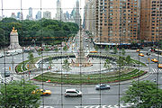
favored small traffic circles. He designed New York City's famous Columbus Circle
Columbus Circle
Columbus Circle, named for Christopher Columbus, is a major landmark and point of attraction in the New York City borough of Manhattan, located at the intersection of Eighth Avenue, Broadway, Central Park South , and Central Park West, at the southwest corner of Central Park. It is the point from...
, which was built in 1905. Other circular intersections were subsequently built in the United States, though many were large diameter 'rotaries' that enabled high speed merge and weave maneuvers. These designs were doomed to failure for two primary reasons:
- It takes a large diameter circle to provide enough room for merging at speed. Although some of these circles were huge (many were in excess of 100 meters or 300 feet in diameter), they weren't large enough for high-speed merging.
- Giving priority to entering traffic means that more vehicles can enter the circulatory roadway than it can handle. The result is congestion within the circle which could not clear without police intervention.
The experience with traffic circles and rotaries in the US was almost entirely negative, characterized by high accident rates and congestion problems. By the mid 1950s, construction of traffic circles and rotaries had ceased entirely. The experience with traffic circles in other countries was not much better until the development of the modern roundabout
Roundabout
A roundabout is the name for a road junction in which traffic moves in one direction around a central island. The word dates from the early 20th century. Roundabouts are common in many countries around the world...
in the United Kingdom during the 1960s.
Examples of traffic circles
Massachusetts
- Airport Rotary, Iyannough Road at Barnstable Road in Hyannis, MassachusettsHyannis, MassachusettsHyannis is the largest of seven villages in Barnstable, Massachusetts. Also it is the commercial and transportation hub of Cape Cod and was designated an urban area as a result of the 1990 census. Because of this, many refer to Hyannis as the "Capital of the Cape"...
on Cape CodCape CodCape Cod, often referred to locally as simply the Cape, is a cape in the easternmost portion of the state of Massachusetts, in the Northeastern United States... - U.S. Route 6U.S. Route 6 in MassachusettsRoute 6 is the portion of the cross-country U.S. Route 6 in the state of Massachusetts. Route 6 runs in the state connecting Providence, Rhode Island to Fall River, New Bedford, and Cape Cod. In the Fall River and New Bedford areas, Route 6 is a secondary highway paralleling Interstate 195...
at Massachusetts Route 6A in Orleans, MassachusettsOrleans, MassachusettsOrleans is a town in Barnstable County, Massachusetts, United States. Barnstable County is coextensive with Cape Cod. The population was 5,890 at the 2010 census....
on Cape CodCape CodCape Cod, often referred to locally as simply the Cape, is a cape in the easternmost portion of the state of Massachusetts, in the Northeastern United States... - Massachusetts Route 2 & Pearson Boulevard, Gardner, MassachusettsGardner, MassachusettsGardner, Massachusetts is a city in Worcester County, Massachusetts, United States. The population was 20,228 as of the 2010 census. Gardner is home to Dunn State Park, Gardner Heritage State Park, Lake Wampanoag Wildlife Sanctuary, and Mount Wachusett Community College.-History:Named in honor of...
, is a rotary interchange. 42°33′51"N 71°58′45"W - Massachusetts Route 3 & Union Street, Braintree, MassachusettsBraintree, MassachusettsThe Town of Braintree is a suburban city in Norfolk County, Massachusetts, United States. Although officially known as a town, Braintree adopted a municipal charter, effective 2008, with a mayor-council form of government and is considered a city under Massachusetts law. The population was 35,744...
, is an oval shaped rotary interchange. 42°12′37"N 70°59′48"W - U.S. Route 3U.S. Route 3U.S. Route 3 is a north–south United States highway that runs from its southern terminus in Cambridge, Massachusetts through New Hampshire to its terminus near Third Connecticut Lake at the Canadian border, where the road continues north as Quebec Route 257.In New Hampshire parts of US 3 are...
& Massachusetts Route 2, Cambridge, MassachusettsCambridge, MassachusettsCambridge is a city in Middlesex County, Massachusetts, United States, in the Greater Boston area. It was named in honor of the University of Cambridge in England, an important center of the Puritan theology embraced by the town's founders. Cambridge is home to two of the world's most prominent...
, in a rotary interchange built in a small space. 42°21′15"N 71°6′39"W - Roosevelt Circle (Interstate 93Interstate 93Interstate 93 is an Interstate Highway in the New England section of the United States. Its southern terminus is in Canton, Massachusetts, in the Boston metropolitan area, at Interstate 95; its northern terminus is near St. Johnsbury, Vermont, at Interstate 91...
, Route 28 & S Border Road), Medford, MassachusettsMedford, MassachusettsMedford is a city in Middlesex County, Massachusetts, in the United States, on the Mystic River, five miles northwest of downtown Boston. In the 2010 U.S. Census, Medford's population was 56,173...
, is an oval shaped rotary interchange. 42°25′45"N 71°6′12"W - Interstate 95Interstate 95 in MassachusettsInterstate 95 is the main highway on the East Coast of the United States, paralleling the Atlantic Ocean from Florida to Maine. The Massachusetts portion of the highway enters from the state of Rhode Island in Attleboro and travels in a northeasterly direction to the junction with Route 128 in...
& U.S. Route 20U.S. Route 20 in MassachusettsThe cross-country U.S. Route 20 runs its easternmost in the U.S. state of Massachusetts. The highway crosses the state border from New Lebanon, New York into Hancock, Massachusetts, and runs eastward into Boston, where it ends at Route 2 in Kenmore Square...
, Waltham, MassachusettsWaltham, MassachusettsWaltham is a city in Middlesex County, Massachusetts, United States, was an early center for the labor movement, and major contributor to the American Industrial Revolution. The original home of the Boston Manufacturing Company, the city was a prototype for 19th century industrial city planning,...
, is a large rotary interchange with the on ramps inside the rotary. 42°22′16"N 71°16′10"W - Interstate 95Interstate 95 in MassachusettsInterstate 95 is the main highway on the East Coast of the United States, paralleling the Atlantic Ocean from Florida to Maine. The Massachusetts portion of the highway enters from the state of Rhode Island in Attleboro and travels in a northeasterly direction to the junction with Route 128 in...
(wrong-way concurrency with US Route 1) & Canton Street, East Street and Allied Drive in Westwood, MassachusettsWestwood, MassachusettsWestwood is a town in Norfolk County, Massachusetts, United States. The population was 14,618 at the 2010 census. In July 2005, CNN/Money and Money magazine ranked Westwood 13th on its list of the 100 Best Places to Live in the United States. Boston Magazine listed Gay Street in Westwood on its...
is a rotary of surface streets with ramps leading to and from the highway below. - Mass Route 147Massachusetts Route 147Route 147 is a west–east state highway in Massachusetts, serving the cities of Agawam and West Springfield. It follows the easternmost few miles of the former route of Route 57 before it was moved onto a limited access freeway a mile south, the Henry E...
and US Route 5 (as a highway) in West Springfield, MassachusettsWest Springfield, MassachusettsThe Town of West Springfield is a city in Hampden County, Massachusetts, United States. It is part of the Springfield, Massachusetts Metropolitan Statistical Area. The population was 28,391 at the 2010 census...
is an open circle rotary with access ramps leading to and from the highway below. - US Route 20 and US Route 5 (as a highway) in West Springfield, MassachusettsWest Springfield, MassachusettsThe Town of West Springfield is a city in Hampden County, Massachusetts, United States. It is part of the Springfield, Massachusetts Metropolitan Statistical Area. The population was 28,391 at the 2010 census...
is a tunnel style rotary with a mini park in the center where the highway passes through the tunnel. Access ramps leading to and from the highway are provided. - Massachusetts Route 16Massachusetts Route 16Route 16 is an east–west state highway in Massachusetts. It begins in the west at an intersection with Route 12 and Route 193 in Webster, just north of the Connecticut state border...
and Massachusetts Route 135 in Wellesley, MassachusettsWellesley, MassachusettsWellesley is a town in Norfolk County, Massachusetts, United States. It is part of Greater Boston. The population was 27,982 at the time of the 2010 census.It is best known as the home of Wellesley College and Babson College...
is the only one in the state where drivers inside the rotary must yield to those entering. - US Route 5, State Route 57 (Massachusetts), and River Road in Agawam, MassachusettsAgawam, MassachusettsThe Town of Agawam is a city in Hampden County, Massachusetts, United States. The population was 28,438 at the 2010 census. Agawam sits on the western side of the Connecticut River, directly across from the City of Springfield, Massachusetts...
is a rotary of River Road and Route 57 with US Route 5 (as a highway) as an overpass with access ramps to and from Route 57. It is notorious for near misses due to the awkward ramp configuration. - Cape Cod Rail TrailCape Cod Rail TrailThe Cape Cod Rail Trail is a paved rail trail located on Cape Cod in Massachusetts.Operated by the Massachusetts Department of Conservation and Recreation, it occupies an abandoned Old Colony Railroad corridor and extends from Route 134 in South Dennis to LeCount Hollow Road in South Wellfleet.Its...
rotary in Harwich, MassachusettsHarwich, MassachusettsHarwich is a New England town on Cape Cod, in Barnstable County in the state of Massachusetts in the United States. Barnstable County is coextensive with Cape Cod. The town is a popular vacation spot, located near the Cape Cod National Seashore. Harwich's beaches are on "the Sound side" of Cape...
41°41′20.0"N 70°5′20.4"W - Exit 5 off Massachusetts Route 6 on Massachusetts Route 149Massachusetts Route 149Route 149 is a short south–north highway on Cape Cod in southeastern Massachusetts.-Route description:The highway is located entirely in the Town of Barnstable, Massachusetts on Cape Cod...
in Marstons Mills, Cape CodCape CodCape Cod, often referred to locally as simply the Cape, is a cape in the easternmost portion of the state of Massachusetts, in the Northeastern United States...
. - Grant Circle (Route 128 and Route 127) in Gloucester, MassachusettsGloucester, MassachusettsGloucester is a city on Cape Ann in Essex County, Massachusetts, in the United States. It is part of Massachusetts' North Shore. The population was 28,789 at the 2010 U.S. Census...
dangerous rotary as it interrupts Route 128 just after the A. Piatt Andrew Bridge where it is not uncommon to see people driving at highway speeds not yield to traffic on the rotary despite various warnings. - Blackburn Circle (Route 128, School House Rd. and Dory Rd.) in Gloucester, MassachusettsGloucester, MassachusettsGloucester is a city on Cape Ann in Essex County, Massachusetts, in the United States. It is part of Massachusetts' North Shore. The population was 28,789 at the 2010 U.S. Census...
large rotary where most of the traffic is continuing traffic along Route 128
Other States
- Monument Circle, surrounding the Soldiers' and Sailors' MonumentSoldiers' and Sailors' Monument (Indianapolis)The Indiana Soldiers' and Sailors' Monument is a tall neoclassical monument in the center of Indianapolis, Indiana that was designed by German architect Bruno Schmitz and completed in 1901....
in downtown Indianapolis, IndianaIndianapolisIndianapolis is the capital of the U.S. state of Indiana, and the county seat of Marion County, Indiana. As of the 2010 United States Census, the city's population is 839,489. It is by far Indiana's largest city and, as of the 2010 U.S... - Lee CircleLee CircleLee Circle is a traffic circle with a monument to Confederate General, Robert E. Lee, in New Orleans, Louisiana. It is located on St. Charles Avenue, where it intersects Howard Avenue. The bronze statue that tops the Doric column was sculpted by Alexander Doyle. Prior to the erection of the...
in New Orleans, Louisiana - Columbus CircleColumbus CircleColumbus Circle, named for Christopher Columbus, is a major landmark and point of attraction in the New York City borough of Manhattan, located at the intersection of Eighth Avenue, Broadway, Central Park South , and Central Park West, at the southwest corner of Central Park. It is the point from...
in New York CityNew York CityNew York is the most populous city in the United States and the center of the New York Metropolitan Area, one of the most populous metropolitan areas in the world. New York exerts a significant impact upon global commerce, finance, media, art, fashion, research, technology, education, and... - Dupont CircleDupont CircleDupont Circle is a traffic circle, park, neighborhood, and historic district in Northwest Washington, D.C. The traffic circle is located at the intersection of Massachusetts Avenue NW, Connecticut Avenue NW, New Hampshire Avenue NW, P Street NW, and 19th Street NW...
in Washington, D.C.Washington, D.C.Washington, D.C., formally the District of Columbia and commonly referred to as Washington, "the District", or simply D.C., is the capital of the United States. On July 16, 1790, the United States Congress approved the creation of a permanent national capital as permitted by the U.S. Constitution.... - MacArthur Drive Traffic Circle in Alexandria, LouisianaAlexandria, LouisianaAlexandria is a city in and the parish seat of Rapides Parish, Louisiana, United States. It lies on the south bank of the Red River in almost the exact geographic center of the state. It is the principal city of the Alexandria metropolitan area which encompasses all of Rapides and Grant parishes....
- U.S. Bypass Highway 1 at U.S. Highway 4 in Portsmouth, New HampshirePortsmouth, New HampshirePortsmouth is a city in Rockingham County, New Hampshire in the United States. It is the largest city but only the fourth-largest community in the county, with a population of 21,233 at the 2010 census...
(Referred to locally as the Portsmouth Traffic CirclePortsmouth Traffic CircleThe Portsmouth Traffic Circle is a four-point rotary in the city of Portsmouth, New Hampshire.-Description:The southern exit of the circle provides access to Interstate 95 north and south, although only northbound I-95 traffic enters here. The eastern and northern exits are part of the U.S. Route 1...
) - Weatherford Circle, U.S. Highway 377 at Texas State Highway 183 in Benbrook, TexasBenbrook, TexasBenbrook is a city located in the southwestern corner of Tarrant County, Texas, in Texas's 12th congressional district, and a suburb of Fort Worth...
(Referred to locally as a Traffic CircleTraffic circleA traffic circle or rotary is a type of circular intersection in which traffic must travel in one direction around a central island. In some countries, traffic entering the circle has the right-of-way and drivers in the circle must yield. In many other countries, traffic entering the circle must...
) - Shirlington Circle (Interstate 395Interstate 395 (District of Columbia-Virginia)Interstate 395 in Washington, D.C., and Virginia is a 13 mile long spur route that begins at a junction with Interstate 95 in Springfield, Virginia and ends in northwest Washington, D.C. It passes underneath the National Mall near the United States Capitol and ends at a junction with U.S...
& Virginia State Route 402Virginia State Route 402State Route 402, also known as part of Quaker Lane, is a primary state highway in Alexandria, Virginia, United States. It runs from State Route 420 north to Shirlington Circle, an interchange with Interstate 395...
), Shirlington, Virginia, has off ramps inside the rotary and multiple at-grade streets. 38°50′26"N 77°5′6"W - Union Square (aka "the Oval"), Milford, New HampshireMilford, New HampshireMilford is a town in Hillsborough County, New Hampshire, United States, on the Souhegan River. The population was 15,115 at the 2010 census. It is the retail and manufacturing center of a six-town area known informally as the Souhegan Valley....
- Benjamin Franklin ParkwayBenjamin Franklin ParkwayBenjamin Franklin Parkway is a scenic boulevard that runs through the cultural heart of Philadelphia, Pennsylvania. Named for favorite son Benjamin Franklin, the mile-long Parkway cuts diagonally across the grid plan pattern of Center City's Northwest quadrant...
in Philadelphia - Bear Mountain Circle in Highland Falls, Orange County, New York, one of a dozen or more in NYS.
Elsewhere
- Place Charles de Gaulle around the Arc de TriompheArc de Triomphe-The design:The astylar design is by Jean Chalgrin , in the Neoclassical version of ancient Roman architecture . Major academic sculptors of France are represented in the sculpture of the Arc de Triomphe: Jean-Pierre Cortot; François Rude; Antoine Étex; James Pradier and Philippe Joseph Henri Lemaire...
in ParisParisParis is the capital and largest city in France, situated on the river Seine, in northern France, at the heart of the Île-de-France region... - Quezon Memorial CircleQuezon Memorial CircleThe Quezon Memorial Circle is a national park and shrine located in Quezon City, former capital of the Philippines . The park is an ellipse bounded by the Elliptical Road. Its main feature is a mausoleum containing the remains of Manuel L...
, Elliptical Road, Quezon CityQuezon CityQuezon City is the former capital and the most populous city in the Philippines. Located on the island of Luzon, Quezon City is one of the cities and municipalities that make up Metro Manila, the National Capital Region. The city was named after Manuel L...
, Metro ManilaMetro ManilaMetropolitan Manila , the National Capital Region , or simply Metro Manila, is the metropolitan region encompassing the City of Manila and its surrounding areas in the Philippines...
(Philippines) - Staples CornerStaples CornerStaples Corner is a major road junction in London, United Kingdom.It has two linked roundabouts and flyovers, which connect the A406 North Circular Road with the A5 Edgware Road and the start of the M1 motorway...
(A406A406 roadThe A406 or the North Circular Road is a road which crosses North London, UK, linking West and East London. It, together with the South Circular Road, forms a ring road through the inner part of Outer London...
& M1M1 motorwayThe M1 is a north–south motorway in England primarily connecting London to Leeds, where it joins the A1 near Aberford. While the M1 is considered to be the first inter-urban motorway to be completed in the United Kingdom, the first road to be built to motorway standard in the country was the...
), Dollis HillDollis HillDollis Hill is an area of north-west London. It lies close to Willesden, in the London Borough of Brent. As a result, Dollis Hill is sometimes referred as being part of Willesden, especially by the national press...
, Greater London, has a freeway ending at a rotary interchange. 51°34′20"N 0°13′44"W - DammamDammamDammam is the capital of the Eastern Province of Saudi Arabia, the most oil-rich region in the world. The judicial and administrative bodies of the province and several government departments are located in the city. Dammam is the largest city in the Eastern Province and third largest in Saudi...
coastal road, Al-Khalij Street, in Saudi ArabiaSaudi ArabiaThe Kingdom of Saudi Arabia , commonly known in British English as Saudi Arabia and in Arabic as as-Sa‘ūdiyyah , is the largest state in Western Asia by land area, constituting the bulk of the Arabian Peninsula, and the second-largest in the Arab World...
with a circumference of approximately 1.9 km (1.2 mi) - Tsuen Kam Interchange, Tsuen WanTsuen Wan New TownTsuen Wan New Town is a new town in Hong Kong. It spans over Tsuen Wan, Kwai Chung and the eastern part of Tsing Yi Island. Traditionally, the officials of Tsuen Wan managed the area of proper Tsuen Wan, Kwai Chung, Tsing Yi Island, Ma Wan and Northeast Lantau Island.In 1982 the Tsuen Wan...
, New TerritoriesNew TerritoriesNew Territories is one of the three main regions of Hong Kong, alongside Hong Kong Island and the Kowloon Peninsula. It makes up 86.2% of Hong Kong's territory. Historically, it is the region described in The Convention for the Extension of Hong Kong Territory...
, Hong Kong - Glorieta de BilbaoGlorieta de BilbaoGlorieta de Bilbao is a star shaped roundabout located in Madrid, Spain; named after the city of Bilbao. The roundabout is famous for being a cross of famous streets: Fuencarral , Carranza, Luchana and Sagasta. Glorieta de Bilbao is also between two of the most historical districts of Madrid:...
, MadridMadridMadrid is the capital and largest city of Spain. The population of the city is roughly 3.3 million and the entire population of the Madrid metropolitan area is calculated to be 6.271 million. It is the third largest city in the European Union, after London and Berlin, and its metropolitan...
, SpainSpainSpain , officially the Kingdom of Spain languages]] under the European Charter for Regional or Minority Languages. In each of these, Spain's official name is as follows:;;;;;;), is a country and member state of the European Union located in southwestern Europe on the Iberian Peninsula... - El ÁngelEl ÁngelEl Ángel de la Independencia , most commonly known by theshortened name El Ángel and officially known as Columna de la Independencia, is a victory column located on a roundabout over Paseo de la Reforma in downtown Mexico City.El Ángel was built to commemorate the centennial of the beginning of...
de la Independencia, in the middle of a large traffic circle ( glorieta ) on the Paseo de la ReformaPaseo de la ReformaPaseo de la Reforma is a wide avenue that runs in a straight line, cutting diagonally across Mexico City. It was designed by Ferdinand von Rosenzweig in the 1860s and modeled after the great boulevards of Europe, such as Vienna's Ringstrasse or the Champs-Élysées in Paris...
, Mexico CityMexico CityMexico City is the Federal District , capital of Mexico and seat of the federal powers of the Mexican Union. It is a federal entity within Mexico which is not part of any one of the 31 Mexican states but belongs to the federation as a whole...
See also
- List of traffic circles in New Jersey
- List of circles in Washington, D.C.
- RoundaboutRoundaboutA roundabout is the name for a road junction in which traffic moves in one direction around a central island. The word dates from the early 20th century. Roundabouts are common in many countries around the world...