

New York State Route 308
Encyclopedia
New York State Route 308 (NY 308) is a short state highway
, 6.19 miles (9.96 km) in length, located entirely in northern Dutchess County
, in the U.S. state
of New York
. It is a major collector road
through mostly rural areas that serves primarily as a shortcut for traffic from the two main north–south routes in the area, U.S. Route 9 (US 9) and NY 9G
, to get to NY 199
and the Taconic State Parkway
. The western end of NY 308 is located within the Rhinebeck Village Historic District
, a 2.6 square miles (6.7 km²) historic district
comprising 272 historical structures. The highway passes near the Dutchess County Fairgrounds, several historical landmarks, and the Landsman Kill
.
Indicated by artifacts found near Lake Sepasco, a small lake along NY 308, the highway began its history in about 1685, when a group of Native Americans
called the Sepasco built the Sepasco Trail; this trail ran from the Hudson River, eastward through modern-day Rhinebeck (then Sepasco or Sepascoot), and ended at Lake Sepasco, following roughly Route 308 and its side roads. The trail remained until 1802, when part of the Ulster and Delaware Turnpike—also known as the Salisbury Turnpike—was chartered over the trail and extended from Salisbury
in Connecticut
to the Susquehanna River
at or near the Town of Jericho (now Bainbridge
).
Route 308 was designated as part of the 1930 renumbering of New York state highways, incorporating a portion of the former Ulster and Delaware Turnpike. The route originally extended from Milan
westward to Rhinecliff to serve a ferry landing on the Hudson River
. It was truncated to US 9 in the 1960s but its former routing to Rhinecliff is still state-maintained as an unsigned reference route. The highway was also intended to be part of the then-new Kingston–Rhinecliff Bridge until plans were changed to involve other routes and the building site for the bridge was moved about 3 miles (5 km) northward.
, a 1670 acres (6.8 km²) historic district
that contains 272 buildings in a variety of architectural style
s dating from over 200 years of the settlement's history. It was added to the National Register of Historic Places
in 1979 as a well-preserved and cohesively built area of historic buildings. A notable attraction is the Beekman Arms Inn, which is located at the corner of NY 308 and US 9. Founded in 1776, it claims to be the oldest continuously-operated inn located in the United States
.
Route 308 begins at US 9 in the Dutchess County
village of Rhinebeck
, at about 200 feet (61 m) in elevation. To the south is the American Legion Park, a small lake, and the Rhinebeck Cemetery. In the center of the village is the Rhinebeck, New York U.S. Post Office
, which is situated very close to the US 9 / NY 308 intersection. The Post Office was established in 1940, and was added to the National Register of Historic Places in 1989. At this point, the Dutchess County Fairgrounds are located just to the north of Route 308. The highway proceeds eastward on East Market Street, soon exiting Rhinebeck while it runs parallel to the Landsman Kill River, a minor tributary of the Hudson River
, which is sometimes known as Landsman Kill or Landsmankill. The Landsman Kill has numerous spawning runs of smelt, alewife
, and blueback herring.
An intersection with County Route 101 (CR 101, named Violet Hill Road) soon follows, as NY 308 turns slightly to the north. It intersects with NY 9G
via an interchange before crossing the stream and gradually turning to the east into a relatively rural area. Between US 9 and NY 9G, NY 308 carries an average of about 6,400 vehicles per day. East of NY 9G, the traffic volume
drops to about 3,700 vehicles per day. Several small lakes surround NY 308 as it intersects CR 52 in the hamlet of Eighmyville and subsequently turns to the northeast, traveling within a large open field. NY 308 then travels west of Sepasco Lake before turning on an eastward route once again. The highway runs initially in a fairly flat area, although passes between two large hills of at least 400 feet (121.9 m). It passes just to the south of the Red Hook Golf Club before coming to an end at NY 199
in Rock City, a hamlet within the town of Milan
that is situated just east of where the Milan, Red Hook
, and Rhinebeck
town lines converge.
, the earliest inhabitants of the northern Dutchess County region were the Mohicans, a Native American nation, about 3,000 years ago. The range of the Mohicans extended from northern Dutchess County to the southern tip of Lake Champlain
, and from the Catskill Mountains
to the Berkshires of Massachusetts
. The total population of the Mohicans was estimated at 8,000 during the time of first contact with the Europeans
, although only 800 remained after the American Revolution
. Artifacts were also recovered along the shore of Lake Sepasco—a small lake NY 308 passes near its ending terminus. Those artifacts recovered included ancient arrowheads, and are now on display at the Museum of Rhinebeck History.
A group of these Native Americans were, in deeds and correspondence, known as the Sepasco Indians, a name specific to Native Americans in the Sepasco area (modern-day Rhinebeck). The word Sepasco probably originated from the tribe's word for little river or stream, sepuus, which is believed to have referred to the Landsman Kill, a stream parallel to NY 308. After the American Civil War
, only a few of the Sepasco were left; the last Sepasco died in a hut near Welch's Cave and Lake Sepasco and was reported in the local newspaper in 1867. By 1685, a trail known as the Sepasco Trail was formed by them and was routed from the Hudson River, eastward through the present-day Village of Rhinebeck, ending at Lake Sepasco. The trail from the Village of Rhinebeck to Lake Sepasco follows roughly modern-day Route 308, in some areas slightly to the south, where the highway's side roads are curved in a pattern similar to that of the Sepasco Trail. It is possible that the trail as a whole existed as a spur of an ancient path that stretched from Rhinebeck to Cornwall, Connecticut
.
The trail remained intact until 1802, when part of the Ulster and Delaware Turnpike was chartered over it "for improving and making a road from the west line of the Town of Salisbury in the State of Connecticut to the Susquehannah River at or near the Town of Jericho [present-day Bainbridge
]". The portion of the Ulster and Delaware Turnpike east of the Hudson River
was also commonly known as the Ulster and Salisbury Turnpike. The turnpike crossed the river using Kingston-Rhinecliff Ferry and used modern Rhinecliff Road and West Market Street to the village center of Rhinecliff, then followed roughly modern NY 308 to the hamlet of Eighmyville. It continued east from there using part of CR 52 to eventually connect with NY 199
. The turnpike corporation operated through the late 19th century.
A bronze plaque attached to a large boulder was erected in November 1922 by Chancellor Livingston Chapter of the Daughters of the American Revolution
on the property of the Beekman Arms, that marked the crossing of the Kings Highway (present-day US 9) and the Ulster and Salisbury Turnpike. Still existent, it reads "This stone marks the crossing of the Kings Highway and the Sepasco Indian Trail, later named the Ulster and Salisbury Turnpike, over which traveled the Connecticut Pioneers to their new homes in western New York."
. West of US 9, NY 308 continued to follow the old turnpike alignment to Hutton Street, where it connected to the Kingston-Rhinecliff Ferry. In 1947, the ferry was the only crossing of the Hudson River between Catskill
(the Rip Van Winkle Bridge
) and Poughkeepsie
(the Mid-Hudson Bridge
)—a distance of 36 miles (58 km)—and the only one serving the Kingston area.
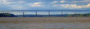 Initial plans for the Kingston–Rhinecliff Bridge, a structure that replaced the ferry between the two locations, called for the bridge to span the Hudson River between downtown Kingston (at Kingston Point) and the village of Rhinebeck
along a corridor similar to that of NY 308. Due to political and economic factors, the bridge site was moved 3 miles (5 km) upstream (northward). The bridge, then partially complete, opened to traffic on February 2, 1957, at which time the ferry service between Kingston and Rhinecliff was terminated. However, NY 308 continued to extend west to Rhinecliff up to the 1960s, when it was truncated to US 9 in the village of Rhinebeck. The section of former NY 308 west of US 9 is now designated as NY 982M, an unsigned reference route.
State highway
State highway, state road or state route can refer to one of three related concepts, two of them related to a state or provincial government in a country that is divided into states or provinces :#A...
, 6.19 miles (9.96 km) in length, located entirely in northern Dutchess County
Dutchess County, New York
Dutchess County is a county located in the U.S. state of New York, in the state's Mid-Hudson Region of the Hudson Valley. The 2010 census lists the population as 297,488...
, in the U.S. state
U.S. state
A U.S. state is any one of the 50 federated states of the United States of America that share sovereignty with the federal government. Because of this shared sovereignty, an American is a citizen both of the federal entity and of his or her state of domicile. Four states use the official title of...
of New York
New York
New York is a state in the Northeastern region of the United States. It is the nation's third most populous state. New York is bordered by New Jersey and Pennsylvania to the south, and by Connecticut, Massachusetts and Vermont to the east...
. It is a major collector road
Collector road
A collector road or distributor road is a low to moderate-capacity road which serve to move traffic from local streets to arterial roads. Unlike arterials, collectors are also designed to provide access to residential properties...
through mostly rural areas that serves primarily as a shortcut for traffic from the two main north–south routes in the area, U.S. Route 9 (US 9) and NY 9G
New York State Route 9G
New York State Route 9G is a state highway in the Hudson Valley of New York in the United States. It runs north from U.S. Route 9 at Poughkeepsie, starting out as Violet Avenue, then follows the Hudson River mostly along the eastern side of the US 9 to Rhinebeck, where the two...
, to get to NY 199
New York State Route 199
New York State Route 199 is a state highway located in the Hudson Valley of New York in the United States. It extends for from an interchange with U.S. Route 9W and US 209 north of Kingston to an intersection with US 44 and NY 22 southwest of Millerton...
and the Taconic State Parkway
Taconic State Parkway
The Taconic State Parkway , is a divided highway between Kensico Dam and Chatham, the longest parkway in the U.S. state of New York. It follows a generally northward route midway between the Hudson River and the Connecticut and Massachusetts state lines...
. The western end of NY 308 is located within the Rhinebeck Village Historic District
Rhinebeck Village Historic District
The Rhinebeck Village Historic District is located along US 9 and NY 308 in Rhinebeck, New York, United States. It is an area of contains 272 buildings in a variety of architectural styles dating from over 200 years of the settlement's history...
, a 2.6 square miles (6.7 km²) historic district
Historic district
A historic district or heritage district is a section of a city which contains older buildings considered valuable for historical or architectural reasons. In some countries, historic districts receive legal protection from development....
comprising 272 historical structures. The highway passes near the Dutchess County Fairgrounds, several historical landmarks, and the Landsman Kill
Kill (body of water)
As a body of water, a kill is a creek. The word comes from the Middle Dutch kille, meaning "riverbed" or "water channel." The modern Dutch term is kil....
.
Indicated by artifacts found near Lake Sepasco, a small lake along NY 308, the highway began its history in about 1685, when a group of Native Americans
Native Americans in the United States
Native Americans in the United States are the indigenous peoples in North America within the boundaries of the present-day continental United States, parts of Alaska, and the island state of Hawaii. They are composed of numerous, distinct tribes, states, and ethnic groups, many of which survive as...
called the Sepasco built the Sepasco Trail; this trail ran from the Hudson River, eastward through modern-day Rhinebeck (then Sepasco or Sepascoot), and ended at Lake Sepasco, following roughly Route 308 and its side roads. The trail remained until 1802, when part of the Ulster and Delaware Turnpike—also known as the Salisbury Turnpike—was chartered over the trail and extended from Salisbury
Salisbury, Connecticut
Salisbury is a town in Litchfield County, Connecticut, United States. The town is the northwest-most in the State of Connecticut. The MA-NY-CT Tri-State Marker is located just on the border of Salisbury...
in Connecticut
Connecticut
Connecticut is a state in the New England region of the northeastern United States. It is bordered by Rhode Island to the east, Massachusetts to the north, and the state of New York to the west and the south .Connecticut is named for the Connecticut River, the major U.S. river that approximately...
to the Susquehanna River
Susquehanna River
The Susquehanna River is a river located in the northeastern United States. At long, it is the longest river on the American east coast that drains into the Atlantic Ocean, and with its watershed it is the 16th largest river in the United States, and the longest river in the continental United...
at or near the Town of Jericho (now Bainbridge
Bainbridge (town), New York
Bainbridge is a town in Chenango County, New York, United States. The population was 3,401 at the 2000 census.The Town of Bainbridge has a village of Bainbridge located within it...
).
Route 308 was designated as part of the 1930 renumbering of New York state highways, incorporating a portion of the former Ulster and Delaware Turnpike. The route originally extended from Milan
Milan, New York
Milan is a town in Dutchess County, New York, United States. The Town of Milan is in the northern part of the county.-History:The area that comprises Milan today was the western part of the Little Nine Partners Patent of 1706. Milan was largely a farming and mill town and remains a very rural...
westward to Rhinecliff to serve a ferry landing on the Hudson River
Hudson River
The Hudson is a river that flows from north to south through eastern New York. The highest official source is at Lake Tear of the Clouds, on the slopes of Mount Marcy in the Adirondack Mountains. The river itself officially begins in Henderson Lake in Newcomb, New York...
. It was truncated to US 9 in the 1960s but its former routing to Rhinecliff is still state-maintained as an unsigned reference route. The highway was also intended to be part of the then-new Kingston–Rhinecliff Bridge until plans were changed to involve other routes and the building site for the bridge was moved about 3 miles (5 km) northward.
Route description
Part of NY 308 is located along the Rhinebeck Village Historic DistrictRhinebeck Village Historic District
The Rhinebeck Village Historic District is located along US 9 and NY 308 in Rhinebeck, New York, United States. It is an area of contains 272 buildings in a variety of architectural styles dating from over 200 years of the settlement's history...
, a 1670 acres (6.8 km²) historic district
Historic district
A historic district or heritage district is a section of a city which contains older buildings considered valuable for historical or architectural reasons. In some countries, historic districts receive legal protection from development....
that contains 272 buildings in a variety of architectural style
Architectural style
Architectural styles classify architecture in terms of the use of form, techniques, materials, time period, region and other stylistic influences. It overlaps with, and emerges from the study of the evolution and history of architecture...
s dating from over 200 years of the settlement's history. It was added to the National Register of Historic Places
National Register of Historic Places
The National Register of Historic Places is the United States government's official list of districts, sites, buildings, structures, and objects deemed worthy of preservation...
in 1979 as a well-preserved and cohesively built area of historic buildings. A notable attraction is the Beekman Arms Inn, which is located at the corner of NY 308 and US 9. Founded in 1776, it claims to be the oldest continuously-operated inn located in the United States
United States
The United States of America is a federal constitutional republic comprising fifty states and a federal district...
.
Route 308 begins at US 9 in the Dutchess County
Dutchess County, New York
Dutchess County is a county located in the U.S. state of New York, in the state's Mid-Hudson Region of the Hudson Valley. The 2010 census lists the population as 297,488...
village of Rhinebeck
Rhinebeck (village), New York
Rhinebeck is a village located in the Town of Rhinebeck in Dutchess County, New York, USA. The population was 2,657 at the 2010 census. It is part of the Poughkeepsie–Newburgh–Middletown, NY Metropolitan Statistical Area as well as the larger New York–Newark–Bridgeport,...
, at about 200 feet (61 m) in elevation. To the south is the American Legion Park, a small lake, and the Rhinebeck Cemetery. In the center of the village is the Rhinebeck, New York U.S. Post Office
U.S. Post Office (Rhinebeck, New York)
The U.S. Post Office in Rhinebeck, New York serves the 12572 ZIP Code. It is located on Mill Street just south of the intersection with NY 308 at the center of the village.It is a stone Colonial Revival structure built in 1940, during the New Deal...
, which is situated very close to the US 9 / NY 308 intersection. The Post Office was established in 1940, and was added to the National Register of Historic Places in 1989. At this point, the Dutchess County Fairgrounds are located just to the north of Route 308. The highway proceeds eastward on East Market Street, soon exiting Rhinebeck while it runs parallel to the Landsman Kill River, a minor tributary of the Hudson River
Hudson River
The Hudson is a river that flows from north to south through eastern New York. The highest official source is at Lake Tear of the Clouds, on the slopes of Mount Marcy in the Adirondack Mountains. The river itself officially begins in Henderson Lake in Newcomb, New York...
, which is sometimes known as Landsman Kill or Landsmankill. The Landsman Kill has numerous spawning runs of smelt, alewife
Alewife
The alewife is a species of herring. There are anadromous and landlocked forms. The landlocked form is also called a sawbelly or mooneye...
, and blueback herring.
An intersection with County Route 101 (CR 101, named Violet Hill Road) soon follows, as NY 308 turns slightly to the north. It intersects with NY 9G
New York State Route 9G
New York State Route 9G is a state highway in the Hudson Valley of New York in the United States. It runs north from U.S. Route 9 at Poughkeepsie, starting out as Violet Avenue, then follows the Hudson River mostly along the eastern side of the US 9 to Rhinebeck, where the two...
via an interchange before crossing the stream and gradually turning to the east into a relatively rural area. Between US 9 and NY 9G, NY 308 carries an average of about 6,400 vehicles per day. East of NY 9G, the traffic volume
Traffic volume
In telecommunication networks, traffic volume is a measure of the total work done by a resource or facility, normally over 24 hours, and is measured in units of erlang-hours...
drops to about 3,700 vehicles per day. Several small lakes surround NY 308 as it intersects CR 52 in the hamlet of Eighmyville and subsequently turns to the northeast, traveling within a large open field. NY 308 then travels west of Sepasco Lake before turning on an eastward route once again. The highway runs initially in a fairly flat area, although passes between two large hills of at least 400 feet (121.9 m). It passes just to the south of the Red Hook Golf Club before coming to an end at NY 199
New York State Route 199
New York State Route 199 is a state highway located in the Hudson Valley of New York in the United States. It extends for from an interchange with U.S. Route 9W and US 209 north of Kingston to an intersection with US 44 and NY 22 southwest of Millerton...
in Rock City, a hamlet within the town of Milan
Milan, New York
Milan is a town in Dutchess County, New York, United States. The Town of Milan is in the northern part of the county.-History:The area that comprises Milan today was the western part of the Little Nine Partners Patent of 1706. Milan was largely a farming and mill town and remains a very rural...
that is situated just east of where the Milan, Red Hook
Red Hook, New York
Red Hook is a town in Dutchess County, New York, United States. The population was reported to be 11,319 during the 2010 census. The name is supposedly derived from the red foliage on trees on a small strip of land on the Hudson River. The town contains two villages; the village of Red Hook and the...
, and Rhinebeck
Rhinebeck (town), New York
Rhinebeck is a town in Dutchess County, New York, United States. The population was 7,548 at the 2010 census.The Town of Rhinebeck in the northwest part of Dutchess County in the Hudson Valley. Rhinebeck is also the name of a village in the town. US Route 9 passes through the town...
town lines converge.
Native Americans and old roads
Indicated by artifacts recovered close to the road in Milan and in other areas along the Hudson RiverHudson River
The Hudson is a river that flows from north to south through eastern New York. The highest official source is at Lake Tear of the Clouds, on the slopes of Mount Marcy in the Adirondack Mountains. The river itself officially begins in Henderson Lake in Newcomb, New York...
, the earliest inhabitants of the northern Dutchess County region were the Mohicans, a Native American nation, about 3,000 years ago. The range of the Mohicans extended from northern Dutchess County to the southern tip of Lake Champlain
Lake Champlain
Lake Champlain is a natural, freshwater lake in North America, located mainly within the borders of the United States but partially situated across the Canada—United States border in the Canadian province of Quebec.The New York portion of the Champlain Valley includes the eastern portions of...
, and from the Catskill Mountains
Catskill Mountains
The Catskill Mountains, an area in New York State northwest of New York City and southwest of Albany, are a mature dissected plateau, an uplifted region that was subsequently eroded into sharp relief. They are an eastward continuation, and the highest representation, of the Allegheny Plateau...
to the Berkshires of Massachusetts
Massachusetts
The Commonwealth of Massachusetts is a state in the New England region of the northeastern United States of America. It is bordered by Rhode Island and Connecticut to the south, New York to the west, and Vermont and New Hampshire to the north; at its east lies the Atlantic Ocean. As of the 2010...
. The total population of the Mohicans was estimated at 8,000 during the time of first contact with the Europeans
European ethnic groups
The ethnic groups in Europe are the various ethnic groups that reside in the nations of Europe. European ethnology is the field of anthropology focusing on Europe....
, although only 800 remained after the American Revolution
American Revolution
The American Revolution was the political upheaval during the last half of the 18th century in which thirteen colonies in North America joined together to break free from the British Empire, combining to become the United States of America...
. Artifacts were also recovered along the shore of Lake Sepasco—a small lake NY 308 passes near its ending terminus. Those artifacts recovered included ancient arrowheads, and are now on display at the Museum of Rhinebeck History.
A group of these Native Americans were, in deeds and correspondence, known as the Sepasco Indians, a name specific to Native Americans in the Sepasco area (modern-day Rhinebeck). The word Sepasco probably originated from the tribe's word for little river or stream, sepuus, which is believed to have referred to the Landsman Kill, a stream parallel to NY 308. After the American Civil War
American Civil War
The American Civil War was a civil war fought in the United States of America. In response to the election of Abraham Lincoln as President of the United States, 11 southern slave states declared their secession from the United States and formed the Confederate States of America ; the other 25...
, only a few of the Sepasco were left; the last Sepasco died in a hut near Welch's Cave and Lake Sepasco and was reported in the local newspaper in 1867. By 1685, a trail known as the Sepasco Trail was formed by them and was routed from the Hudson River, eastward through the present-day Village of Rhinebeck, ending at Lake Sepasco. The trail from the Village of Rhinebeck to Lake Sepasco follows roughly modern-day Route 308, in some areas slightly to the south, where the highway's side roads are curved in a pattern similar to that of the Sepasco Trail. It is possible that the trail as a whole existed as a spur of an ancient path that stretched from Rhinebeck to Cornwall, Connecticut
Cornwall, Connecticut
Cornwall is a town in Litchfield County, Connecticut, United States. The population was 1,434 at the 2000 census.In 1939 poet Mark Van Doren wrote "The Hills of Little Cornwall", a short poem in which the beauties of the countryside were portrayed as seductive:The town was also home to the Foreign...
.
The trail remained intact until 1802, when part of the Ulster and Delaware Turnpike was chartered over it "for improving and making a road from the west line of the Town of Salisbury in the State of Connecticut to the Susquehannah River at or near the Town of Jericho [present-day Bainbridge
Bainbridge (town), New York
Bainbridge is a town in Chenango County, New York, United States. The population was 3,401 at the 2000 census.The Town of Bainbridge has a village of Bainbridge located within it...
]". The portion of the Ulster and Delaware Turnpike east of the Hudson River
Hudson River
The Hudson is a river that flows from north to south through eastern New York. The highest official source is at Lake Tear of the Clouds, on the slopes of Mount Marcy in the Adirondack Mountains. The river itself officially begins in Henderson Lake in Newcomb, New York...
was also commonly known as the Ulster and Salisbury Turnpike. The turnpike crossed the river using Kingston-Rhinecliff Ferry and used modern Rhinecliff Road and West Market Street to the village center of Rhinecliff, then followed roughly modern NY 308 to the hamlet of Eighmyville. It continued east from there using part of CR 52 to eventually connect with NY 199
New York State Route 199
New York State Route 199 is a state highway located in the Hudson Valley of New York in the United States. It extends for from an interchange with U.S. Route 9W and US 209 north of Kingston to an intersection with US 44 and NY 22 southwest of Millerton...
. The turnpike corporation operated through the late 19th century.
A bronze plaque attached to a large boulder was erected in November 1922 by Chancellor Livingston Chapter of the Daughters of the American Revolution
Daughters of the American Revolution
The Daughters of the American Revolution is a lineage-based membership organization for women who are descended from a person involved in United States' independence....
on the property of the Beekman Arms, that marked the crossing of the Kings Highway (present-day US 9) and the Ulster and Salisbury Turnpike. Still existent, it reads "This stone marks the crossing of the Kings Highway and the Sepasco Indian Trail, later named the Ulster and Salisbury Turnpike, over which traveled the Connecticut Pioneers to their new homes in western New York."
Designation
The NY 308 designation was assigned as part of the 1930 renumbering of New York state highways. At the time, it extended from the Rhinecliff ferry landing to Rock City in the town of MilanMilan, New York
Milan is a town in Dutchess County, New York, United States. The Town of Milan is in the northern part of the county.-History:The area that comprises Milan today was the western part of the Little Nine Partners Patent of 1706. Milan was largely a farming and mill town and remains a very rural...
. West of US 9, NY 308 continued to follow the old turnpike alignment to Hutton Street, where it connected to the Kingston-Rhinecliff Ferry. In 1947, the ferry was the only crossing of the Hudson River between Catskill
Catskill (village), New York
Catskill is a village in Greene County, New York, USA. The population was 4,081 at the 2010 census.The Village of Catskill is in the northeast part of the Town of Catskill. Catskill is the county seat of Greene County.-History:...
(the Rip Van Winkle Bridge
Rip Van Winkle Bridge
The Rip Van Winkle Bridge is a cantilever bridge spanning the Hudson River between Hudson, NY and Catskill, New York. The structure carries NY 23 across the river, connecting on the west side, US 9W and NY 385 with NY 9G on the east side. The bridge was built by the newly created New York State...
) and Poughkeepsie
Poughkeepsie (city), New York
Poughkeepsie is a city in the state of New York, United States, which serves as the county seat of Dutchess County. Poughkeepsie is located in the Hudson River Valley midway between New York City and Albany...
(the Mid-Hudson Bridge
Mid-Hudson Bridge
The Mid-Hudson Bridge is a toll suspension bridge which carries US 44 and NY 55 across the Hudson River between Poughkeepsie and Highland in the state of New York. Governor and local resident Franklin D. Roosevelt and his wife Eleanor attended the opening ceremony on August 25, 1930. The bridge...
)—a distance of 36 miles (58 km)—and the only one serving the Kingston area.
Rhinebeck (village), New York
Rhinebeck is a village located in the Town of Rhinebeck in Dutchess County, New York, USA. The population was 2,657 at the 2010 census. It is part of the Poughkeepsie–Newburgh–Middletown, NY Metropolitan Statistical Area as well as the larger New York–Newark–Bridgeport,...
along a corridor similar to that of NY 308. Due to political and economic factors, the bridge site was moved 3 miles (5 km) upstream (northward). The bridge, then partially complete, opened to traffic on February 2, 1957, at which time the ferry service between Kingston and Rhinecliff was terminated. However, NY 308 continued to extend west to Rhinecliff up to the 1960s, when it was truncated to US 9 in the village of Rhinebeck. The section of former NY 308 west of US 9 is now designated as NY 982M, an unsigned reference route.