

List of longest rivers of Mexico
Encyclopedia
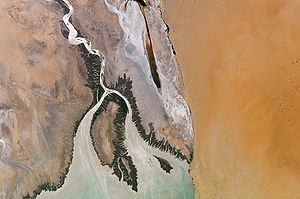
Among the longest rivers of Mexico are 26 streams of at least 250 km (155.3 mi). In the case of rivers such as the Colorado
, the length listed in the table below is solely that of the main stem
. In the case of the Grijalva
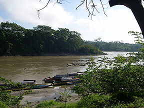
and Usumacinta
, it is the combined lengths of two river systems that share a delta. In the case of the Nazas
and Aguanaval
, it is the combined lengths of separate rivers that flow into the same closed basin.
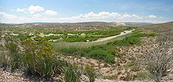
Three rivers in this list cross international boundaries or form them. The Colorado and the Rio Grande
begin in the United States and flow into Mexico, while the Usumacinta begins in Guatemala
and flows into Mexico.
The primary source for the length, watershed, and surface runoff data in the table below is the 10th edition of Statistics on Water in Mexico, published by the National Water Commission in Mexico (CONAGUA); exceptions are as noted. U.S. state
s and departments of Guatemala
appear in italics in the "States" column. Abbreviations are as follows: "km" for "kilometre", "mi" for "mile", "s" for "second", "m" for "metre", and "ft" for "foot".
Colorado River
The Colorado River , is a river in the Southwestern United States and northwestern Mexico, approximately long, draining a part of the arid regions on the western slope of the Rocky Mountains. The watershed of the Colorado River covers in parts of seven U.S. states and two Mexican states...
, the length listed in the table below is solely that of the main stem
Main Stem
"Main Stem" is 1942 instrumental by Duke Ellington and His Famous Orchestra. Although recorded in 1942, the single would not be released until 1944 where it was Duke Ellington's last of four number one's on the Harlem Hit Parade. "Main Stem" would also peak at number twenty on the pop chart"Main...
. In the case of the Grijalva
Grijalva River
Grijalva River, formerly known as Tabasco River. is a 480 km long river in southeastern Mexico. It is named after Juan de Grijalva who visited the area in 1518. The river rises in Chiapas highlands and flows from Chiapas to the state of Tabasco through the Sumidero Canyon into the Bay of...
and Usumacinta
Usumacinta River
The Usumacinta River is a river in southeastern Mexico and northwestern Guatemala. It is formed by the junction of the Pasión River, which arises in the Sierra de Santa Cruz and the Salinas River, also known as the Chixoy, or the Negro, which descends from the Sierra Madre de Guatemala...
, it is the combined lengths of two river systems that share a delta. In the case of the Nazas
Nazas River
The Nazas River is a river located in northern Mexico, in territory of the states of Coahuila and Durango. It is part of the endorheic Bolsón de Mapimí. It is only long, but irrigates an area of 71,906 km² in the middle of the desert. The Nazas is also nurtured by the San Juan, Ramos, Potreritos,...
and Aguanaval
Aguanaval River
-Geography:It originates in the southern Sierra Madre Occidental range of Zacatecas state, and flows generally north through Zacatecas and Durango states to empty into the endorheic Bolsón de Mapimí, in Coahuila state.-Use:...
, it is the combined lengths of separate rivers that flow into the same closed basin.
Three rivers in this list cross international boundaries or form them. The Colorado and the Rio Grande
Rio Grande
The Rio Grande is a river that flows from southwestern Colorado in the United States to the Gulf of Mexico. Along the way it forms part of the Mexico – United States border. Its length varies as its course changes...
begin in the United States and flow into Mexico, while the Usumacinta begins in Guatemala
Guatemala
Guatemala is a country in Central America bordered by Mexico to the north and west, the Pacific Ocean to the southwest, Belize to the northeast, the Caribbean to the east, and Honduras and El Salvador to the southeast...
and flows into Mexico.
The primary source for the length, watershed, and surface runoff data in the table below is the 10th edition of Statistics on Water in Mexico, published by the National Water Commission in Mexico (CONAGUA); exceptions are as noted. U.S. state
U.S. state
A U.S. state is any one of the 50 federated states of the United States of America that share sovereignty with the federal government. Because of this shared sovereignty, an American is a citizen both of the federal entity and of his or her state of domicile. Four states use the official title of...
s and departments of Guatemala
Departments of Guatemala
||Guatemala is divided into 22 departments :#Alta Verapaz#Baja Verapaz#Chimaltenango#Chiquimula#Petén#El Progreso#El Quiché#Escuintla#Guatemala#Huehuetenango#Izabal#Jalapa#Jutiapa#Quetzaltenango#Retalhuleu#Sacatepéquez...
appear in italics in the "States" column. Abbreviations are as follows: "km" for "kilometre", "mi" for "mile", "s" for "second", "m" for "metre", and "ft" for "foot".
| # | Name | Mouth | Length | Watershed area |
Annual surface runoff | States | Image |
|---|---|---|---|---|---|---|---|
| 1 | Rio Grande Rio Grande The Rio Grande is a river that flows from southwestern Colorado in the United States to the Gulf of Mexico. Along the way it forms part of the Mexico – United States border. Its length varies as its course changes... |
Gulf of Mexico Gulf of Mexico The Gulf of Mexico is a partially landlocked ocean basin largely surrounded by the North American continent and the island of Cuba. It is bounded on the northeast, north and northwest by the Gulf Coast of the United States, on the southwest and south by Mexico, and on the southeast by Cuba. In... 25°57′22"N 97°08′43"W |
3,108 km 1,931 mi |
466,939 km2 180,286 mi2 |
6,090 x 106 m3 2.15 x 1011 ft3 |
Colorado Colorado Colorado is a U.S. state that encompasses much of the Rocky Mountains as well as the northeastern portion of the Colorado Plateau and the western edge of the Great Plains... , New Mexico New Mexico New Mexico is a state located in the southwest and western regions of the United States. New Mexico is also usually considered one of the Mountain States. With a population density of 16 per square mile, New Mexico is the sixth-most sparsely inhabited U.S... , Texas Texas Texas is the second largest U.S. state by both area and population, and the largest state by area in the contiguous United States.The name, based on the Caddo word "Tejas" meaning "friends" or "allies", was applied by the Spanish to the Caddo themselves and to the region of their settlement in... , Chihuahua, Coahuila Coahuila Coahuila, formally Coahuila de Zaragoza , officially Estado Libre y Soberano de Coahuila de Zaragoza is one of the 31 states which, with the Federal District, comprise the 32 Federal Entities of Mexico... , Nuevo León Nuevo León Nuevo León It is located in Northeastern Mexico. It is bordered by the states of Tamaulipas to the north and east, San Luis Potosí to the south, and Coahuila to the west. To the north, Nuevo León has a 15 kilometer stretch of the U.S.-Mexico border adjacent to the U.S... , Tamaulipas Tamaulipas Tamaulipas officially Estado Libre y Soberano de Tamaulipas is one of the 31 states which, with the Federal District, comprise the 32 Federal Entities of Mexico. It is divided in 43 municipalities and its capital city is Ciudad Victoria. The capital city was named after Guadalupe Victoria, the... |
 |
| 2 | Colorado River Colorado River The Colorado River , is a river in the Southwestern United States and northwestern Mexico, approximately long, draining a part of the arid regions on the western slope of the Rocky Mountains. The watershed of the Colorado River covers in parts of seven U.S. states and two Mexican states... |
Gulf of California Gulf of California The Gulf of California is a body of water that separates the Baja California Peninsula from the Mexican mainland... 31°48′57"N 114°48′22"W |
tyle="background:#fffdd0;"|2,337 km 1,452 mi |
630,783 km2 243,547 mi2 |
17,898 x 106 m3 6.321 x 1011 ft3 |
Colorado Colorado Colorado is a U.S. state that encompasses much of the Rocky Mountains as well as the northeastern portion of the Colorado Plateau and the western edge of the Great Plains... , Utah Utah Utah is a state in the Western United States. It was the 45th state to join the Union, on January 4, 1896. Approximately 80% of Utah's 2,763,885 people live along the Wasatch Front, centering on Salt Lake City. This leaves vast expanses of the state nearly uninhabited, making the population the... , Arizona Arizona Arizona ; is a state located in the southwestern region of the United States. It is also part of the western United States and the mountain west. The capital and largest city is Phoenix... , Nevada Nevada Nevada is a state in the western, mountain west, and southwestern regions of the United States. With an area of and a population of about 2.7 million, it is the 7th-largest and 35th-most populous state. Over two-thirds of Nevada's people live in the Las Vegas metropolitan area, which contains its... , California California California is a state located on the West Coast of the United States. It is by far the most populous U.S. state, and the third-largest by land area... , Sonora Sonora Sonora officially Estado Libre y Soberano de Sonora is one of the 31 states which, with the Federal District, comprise the 32 Federal Entities of Mexico. It is divided into 72 municipalities; the capital city is Hermosillo.... , Baja California Baja California Baja California officially Estado Libre y Soberano de Baja California is one of the 31 states which, with the Federal District, comprise the 32 Federal Entities of Mexico. It is both the northernmost and westernmost state of Mexico. Before becoming a state in 1953, the area was known as the North... |
 |
| 3 | Grijalva Grijalva River Grijalva River, formerly known as Tabasco River. is a 480 km long river in southeastern Mexico. It is named after Juan de Grijalva who visited the area in 1518. The river rises in Chiapas highlands and flows from Chiapas to the state of Tabasco through the Sumidero Canyon into the Bay of... –Usumacinta River Usumacinta River The Usumacinta River is a river in southeastern Mexico and northwestern Guatemala. It is formed by the junction of the Pasión River, which arises in the Sierra de Santa Cruz and the Salinas River, also known as the Chixoy, or the Negro, which descends from the Sierra Madre de Guatemala... s |
Bay of Campeche Bay of Campeche The Bay of Campeche is the southern bight of the Gulf of Mexico. It is surrounded on three sides by the Mexican states of Campeche, Tabasco and Veracruz. It was named by Francisco Hernández de Córdoba and Antonio de Alaminos during their expedition in 1517... 18°35′20"N 92°41′20"W |
1,911 km 1,187 mi |
128,390 km2 49,570 mi2 |
115,536 x 106 m3 4.0801 x 1012 ft3 |
Petén, Chiapas Chiapas Chiapas officially Estado Libre y Soberano de Chiapas is one of the 31 states that, with the Federal District, comprise the 32 Federal Entities of Mexico. It is divided in 118 municipalities and its capital city is Tuxtla Gutierrez. Other important cites in Chiapas include San Cristóbal de las... , Tabasco Tabasco Tabasco officially Estado Libre y Soberano de Tabasco is one of the 31 states which, with the Federal District, comprise the 32 Federal Entities of Mexico. It is divided in 17 municipalities and its capital city is Villahermosa.... |
 |
| 4 | Nazas Nazas River The Nazas River is a river located in northern Mexico, in territory of the states of Coahuila and Durango. It is part of the endorheic Bolsón de Mapimí. It is only long, but irrigates an area of 71,906 km² in the middle of the desert. The Nazas is also nurtured by the San Juan, Ramos, Potreritos,... –Aguanaval River Aguanaval River -Geography:It originates in the southern Sierra Madre Occidental range of Zacatecas state, and flows generally north through Zacatecas and Durango states to empty into the endorheic Bolsón de Mapimí, in Coahuila state.-Use:... s |
Bolsón de Mapimí Bolsón de Mapimí The Bolsón de Mapimí is an endorheic river basin located in the center-north of the Mexican Plateau.It is also known as the Comarca Lagunera, and is shared by the states of Durango, Coahuila, Chihuahua, and Zacatecas... 25°12′00"N 104°12′00"W |
1,081 km 672 mi |
89,239 km2 34,455 mi2 |
1,912 x 106 m3 6.75 x 1010 ft3 |
Durango Durango Durango officially Estado Libre y Soberano de Durango is one of the 31 states which, with the Federal District, comprise the 32 Federal Entities of Mexico. The state is located in Northwest Mexico. With a population of 1,632,934, it has Mexico's second-lowest population density, after Baja... , Zacatecas Zacatecas Zacatecas officially Estado Libre y Soberano de Zacatecas is one of the 31 states which, with the Federal District, comprise the 32 Federal Entities of Mexico. It is divided in 58 municipalities and its capital city is Zacatecas.... , Coahuila Coahuila Coahuila, formally Coahuila de Zaragoza , officially Estado Libre y Soberano de Coahuila de Zaragoza is one of the 31 states which, with the Federal District, comprise the 32 Federal Entities of Mexico... |
|
| 5 | Culiacán River Culiacán River The Culiacán River is a river that is formed by the connection of the Tamazula River and Humaya River in Culiacán, Sinaloa, Mexico. The water from the river then flows to the Pacific Ocean.... |
Pacific Ocean Pacific Ocean The Pacific Ocean is the largest of the Earth's oceanic divisions. It extends from the Arctic in the north to the Southern Ocean in the south, bounded by Asia and Australia in the west, and the Americas in the east.At 165.2 million square kilometres in area, this largest division of the World... 24°29′32"N 107°43′55"W |
875 km 544 mi |
15,731 km2 6,074 mi2 |
3,161 x 106 m3 1.116 x 1011 ft3 |
Sinaloa Sinaloa Sinaloa officially Estado Libre y Soberano de Sinaloa is one of the 31 states which, with the Federal District, comprise the 32 Federal Entities of Mexico. It is divided in 18 municipalities and its capital city is Culiacán Rosales.... |
 |
| 6 | Balsas River Balsas River The Balsas River is a major river of south-central Mexico. The basin flows through the states of Puebla, Morelos, Guerrero, and Mexico. The river empties into the Pacific Ocean at Mangrove Point, adjacent to the city of Lázaro Cárdenas, Michoacán... |
Pacific Ocean Pacific Ocean The Pacific Ocean is the largest of the Earth's oceanic divisions. It extends from the Arctic in the north to the Southern Ocean in the south, bounded by Asia and Australia in the west, and the Americas in the east.At 165.2 million square kilometres in area, this largest division of the World... 17°56′22"N 102°08′14"W |
770 km 478 mi |
117,406 km2 45,331 mi2 |
16,587 x 106 m3 5.858 x 1011 ft3 |
Puebla Puebla Puebla officially Estado Libre y Soberano de Puebla is one of the 31 states which, with the Federal District, comprise the 32 Federal Entities of Mexico. It is divided in 217 municipalities and its capital city is Puebla.... , Morelos Morelos Morelos officially Estado Libre y Soberano de Morelos is one of the 31 states which, with the Federal District, comprise the 32 Federal Entities of Mexico. It is divided in 33 municipalities and its capital city is Cuernavaca.... , Michoacán Michoacán Michoacán officially Estado Libre y Soberano de Michoacán de Ocampo is one of the 31 states which, with the Federal District, comprise the 32 Federal Entities of Mexico. It is divided in 113 municipalities and its capital city is Morelia... , Guerrero Guerrero Guerrero officially Estado Libre y Soberano de Guerrero is one of the 31 states which, with the Federal District, comprise the 32 Federal Entities of Mexico. It is divided in 81 municipalities and its capital city is Chilpancingo.... |
 |
| 7 | Lerma River Lerma River The Lerma Santiago River is Mexico's second longest river. It is a river in west-central Mexico that begins in Mexican Plateau at an altitude over above sea level, and ends where it empties into Lake Chapala, Mexico's largest lake, near Guadalajara, Jalisco... |
Lake Chapala Lake Chapala Lake Chapala is Mexico's largest freshwater lake. It lies in the municipalities of Chapala, Jocotepec , Poncitlán, and Jamay, in Jalisco, and in Venustiano Carranza and Cojumatlán de Régules, in Michoacán.- Geographic Features :... 20°15′00"N 103°00′00"W |
708 km 440 mi |
47,116 km2 18,192 mi2 |
4,742 x 106 m3 1.675 x 1011 ft3 |
State of Mexico, Querétaro Querétaro Querétaro officially Estado Libre y Soberano de Querétaro de Arteaga is one of the 31 states which, with the Federal District, comprise the 32 Federal Entities of Mexico. It is divided into 18 municipalities and its capital city is Santiago de Querétaro.... , Michoacán Michoacán Michoacán officially Estado Libre y Soberano de Michoacán de Ocampo is one of the 31 states which, with the Federal District, comprise the 32 Federal Entities of Mexico. It is divided in 113 municipalities and its capital city is Morelia... , Guanajuato Guanajuato Guanajuato officially Estado Libre y Soberano de Guanajuato is one of the 31 states which, with the Federal District, comprise the 32 Federal Entities of Mexico. It is divided in 46 municipalities and its capital city is Guanajuato.... , Jalisco Jalisco Jalisco officially Estado Libre y Soberano de Jalisco is one of the 31 states which, with the Federal District, comprise the 32 Federal Entities of Mexico. It is located in Western Mexico and divided in 125 municipalities and its capital city is Guadalajara.It is one of the more important states... |
|
| 8 | Rio Grande de Santiago Río Grande de Santiago The Río Grande de Santiago is one of the longest rivers in Mexico, measuring up long. The river begins at Lake Chapala and continues roughly north-west through the Sierra Madre Occidental, receiving the Verde, Juchipila, Bolaños, and other tributaries... |
Pacific Ocean Pacific Ocean The Pacific Ocean is the largest of the Earth's oceanic divisions. It extends from the Arctic in the north to the Southern Ocean in the south, bounded by Asia and Australia in the west, and the Americas in the east.At 165.2 million square kilometres in area, this largest division of the World... 21°38′00"N 105°26′43"W |
562 km 349 mi |
76,416 km2 29,504 mi2 |
7,849 x 106 m3 2.772 x 1011 ft3 |
Jalisco Jalisco Jalisco officially Estado Libre y Soberano de Jalisco is one of the 31 states which, with the Federal District, comprise the 32 Federal Entities of Mexico. It is located in Western Mexico and divided in 125 municipalities and its capital city is Guadalajara.It is one of the more important states... , Nayarit Nayarit Nayarit officially Estado Libre y Soberano de Nayarit is one of the 31 states which, with the Federal District, comprise the 32 Federal Entities of Mexico. It is divided in 20 municipalities and its capital city is Tepic.It is located in Western Mexico... |
 |
| 9 | Fuerte River Fuerte River The Fuerte River is a river in the northwestern Mexican state of Sinaloa. It begins at the junction of the Verde and Urique rivers, on the Sierra Madre Occidental mountain range. It flows generally southwest for a distance of 290 km, emptying into the Gulf of California at Lechuguilla Island,... |
Gulf of California Gulf of California The Gulf of California is a body of water that separates the Baja California Peninsula from the Mexican mainland... 25°48′00"N 109°25′00"W |
540 km 336 mi |
33,590 km2 12,970 mi2 |
5,176 x 106 m3 1.828 x 1011 ft3 |
Sinaloa Sinaloa Sinaloa officially Estado Libre y Soberano de Sinaloa is one of the 31 states which, with the Federal District, comprise the 32 Federal Entities of Mexico. It is divided in 18 municipalities and its capital city is Culiacán Rosales.... |
|
| 10 | Pánuco River Pánuco River The Pánuco River is a river in Mexico that flows from the River Moctezuma in the Valley of Mexico to the Gulf of Mexico.At its source, it serves as a channel for water-drainage for Mexico City. From there, it becomes the state border between Hidalgo and Querétaro as it moves towards San Luis... |
Gulf of Mexico Gulf of Mexico The Gulf of Mexico is a partially landlocked ocean basin largely surrounded by the North American continent and the island of Cuba. It is bounded on the northeast, north and northwest by the Gulf Coast of the United States, on the southwest and south by Mexico, and on the southeast by Cuba. In... 22°16′00"N 97°47′00"W |
510 km 317 mi |
84,956 km2 32,802 mi2 |
20,330 x 106 m3 7.18 x 1011 ft3 |
Veracruz Veracruz Veracruz, formally Veracruz de Ignacio de la Llave officially Estado Libre y Soberano de Veracruz de Ignacio de la Llave , is one of the 31 states that, along with the Federal District, comprise the 32 federative entities of Mexico. It is divided in 212 municipalities and its capital city is... |
|
| 11 | Rio Conchos Rio Conchos The Rio Conchos is a large river in the Mexican state of Chihuahua. It joins the Río Bravo del Norte at the town of Ojinaga, Chihuahua.-Description:... |
Rio Grande Rio Grande The Rio Grande is a river that flows from southwestern Colorado in the United States to the Gulf of Mexico. Along the way it forms part of the Mexico – United States border. Its length varies as its course changes... 25°07′00"N 98°32′00"W |
485 km 301 mi |
68,386 km2 26,404 mi2 |
2,714 x 106 m3 9.58 x 1010 ft3 |
Chihuahua | |
| 12 | Sonora River Sonora River Río Sonora is a 402-kilometer-long river of Mexico. It lies on the Pacific slope of the Mexican state of Sonora and it runs into the Gulf of California.-Watershed:... |
Gulf of California Gulf of California The Gulf of California is a body of water that separates the Baja California Peninsula from the Mexican mainland... 28°47′06"N 111°55′11"W |
421 km 262 mi |
27,740 km2 10,710 mi2 |
408 x 106 m3 1.44 x 1010 ft3 |
Sonora Sonora Sonora officially Estado Libre y Soberano de Sonora is one of the 31 states which, with the Federal District, comprise the 32 Federal Entities of Mexico. It is divided into 72 municipalities; the capital city is Hermosillo.... |
|
| 13 | Soto La Marina River Soto La Marina River -References:*Atlas of Mexico, 1975 .*The Prentice Hall American World Atlas, 1984.*Rand McNally, The New International Atlas, 1993.... |
Gulf of Mexico Gulf of Mexico The Gulf of Mexico is a partially landlocked ocean basin largely surrounded by the North American continent and the island of Cuba. It is bounded on the northeast, north and northwest by the Gulf Coast of the United States, on the southwest and south by Mexico, and on the southeast by Cuba. In... 23°45′56"N 97°44′13"W |
416 km 258 km |
21,183 km2 8,179 mi2 |
2,086 x 106 m3 7.37 x 1010 ft3 |
Tamaulipas Tamaulipas Tamaulipas officially Estado Libre y Soberano de Tamaulipas is one of the 31 states which, with the Federal District, comprise the 32 Federal Entities of Mexico. It is divided in 43 municipalities and its capital city is Ciudad Victoria. The capital city was named after Guadalupe Victoria, the... |
|
| 14 | Yaqui River Yaqui River The Yaqui River is a river in the state of Sonora in northwestern Mexico. Being the largest river system in the state of Sonora, the Yaqui river is used for irrigation.... |
Gulf of California Gulf of California The Gulf of California is a body of water that separates the Baja California Peninsula from the Mexican mainland... 27°39′17"N 110°37′26"W |
410 km 255 mi |
72,540 km2 28,010 mi2 |
3,163 x 106 m3 1.117 x 1011 ft3 |
Sonora Sonora Sonora officially Estado Libre y Soberano de Sonora is one of the 31 states which, with the Federal District, comprise the 32 Federal Entities of Mexico. It is divided into 72 municipalities; the capital city is Hermosillo.... |
|
| 15 | Sinaloa River Sinaloa River -References:*Atlas of Mexico, 1975 .*The Prentice Hall American World Atlas, 1984.*Rand McNally, The New International Atlas, 1993.... |
Gulf of California Gulf of California The Gulf of California is a body of water that separates the Baja California Peninsula from the Mexican mainland... 25°16′51"N 108°29′43"W |
400 km 249 mi |
12,260 km2 4,730 mi2 |
2,126 x 106 m3 7.51 x 1010 ft3 |
Sinaloa Sinaloa Sinaloa officially Estado Libre y Soberano de Sinaloa is one of the 31 states which, with the Federal District, comprise the 32 Federal Entities of Mexico. It is divided in 18 municipalities and its capital city is Culiacán Rosales.... |
|
| 16 | San Fernando River San Fernando River -References:*Atlas of Mexico, 1975 .*The Prentice Hall American World Atlas, 1984.*Rand McNally, The New International Atlas, 1993.... |
Gulf of Mexico Gulf of Mexico The Gulf of Mexico is a partially landlocked ocean basin largely surrounded by the North American continent and the island of Cuba. It is bounded on the northeast, north and northwest by the Gulf Coast of the United States, on the southwest and south by Mexico, and on the southeast by Cuba. In... 24°55′00"N 97°40′00"W |
400 km 249 mi |
17,744 km2 6,851 mi2 |
1,545 x 106 m3 5.46 x 1010 ft3 |
Tamaulipas Tamaulipas Tamaulipas officially Estado Libre y Soberano de Tamaulipas is one of the 31 states which, with the Federal District, comprise the 32 Federal Entities of Mexico. It is divided in 43 municipalities and its capital city is Ciudad Victoria. The capital city was named after Guadalupe Victoria, the... |
|
| 17 | Mayo River | Gulf of California Gulf of California The Gulf of California is a body of water that separates the Baja California Peninsula from the Mexican mainland... 26°45′00"N 109°47′00"W |
386 km 240 mi |
15,113 km2 5,835 mi2 |
1,232 x 106 m3 4.35 x 1010 ft3 |
Chihuahua, Sonora Sonora Sonora officially Estado Libre y Soberano de Sonora is one of the 31 states which, with the Federal District, comprise the 32 Federal Entities of Mexico. It is divided into 72 municipalities; the capital city is Hermosillo.... |
|
| 18 | Tecolutla River | Gulf of Mexico Gulf of Mexico The Gulf of Mexico is a partially landlocked ocean basin largely surrounded by the North American continent and the island of Cuba. It is bounded on the northeast, north and northwest by the Gulf Coast of the United States, on the southwest and south by Mexico, and on the southeast by Cuba. In... 20°29′00"N 97°00′00"W |
375 km 233 mi |
7,903 km2 3,051 mi2 |
6,095 x 106 m3 2.152 x 1011 ft3 |
Veracruz Veracruz Veracruz, formally Veracruz de Ignacio de la Llave officially Estado Libre y Soberano de Veracruz de Ignacio de la Llave , is one of the 31 states that, along with the Federal District, comprise the 32 federative entities of Mexico. It is divided in 212 municipalities and its capital city is... |
|
| 19 | Jamapa River Jamapa River The Río Jamapa is located in the Mexican state of Veracruz, forming in Citlaltépetl and pouring into the Gulf of Mexico in the municipality of Boca del Río .... |
Gulf of Mexico Gulf of Mexico The Gulf of Mexico is a partially landlocked ocean basin largely surrounded by the North American continent and the island of Cuba. It is bounded on the northeast, north and northwest by the Gulf Coast of the United States, on the southwest and south by Mexico, and on the southeast by Cuba. In... 19°02′00"N 96°08′00"W |
368 km 229 mi |
4,061 km2 1,568 mi2 |
2,563 x 106 m3 9.05 x 1010 ft3 |
Veracruz Veracruz Veracruz, formally Veracruz de Ignacio de la Llave officially Estado Libre y Soberano de Veracruz de Ignacio de la Llave , is one of the 31 states that, along with the Federal District, comprise the 32 federative entities of Mexico. It is divided in 212 municipalities and its capital city is... |
|
| 20 | Papaloapan River Papaloapan River The Papaloapan River is one of the main rivers of the Mexican state of Veracruz. Its name is derived from the Nahuatl papalotl and apan .... |
Gulf of Mexico Gulf of Mexico The Gulf of Mexico is a partially landlocked ocean basin largely surrounded by the North American continent and the island of Cuba. It is bounded on the northeast, north and northwest by the Gulf Coast of the United States, on the southwest and south by Mexico, and on the southeast by Cuba. In... 18°42′00"N 95°38′00"W |
354 km 220 mi |
46,517 km2 17,960 mi2 |
44,662 x 106 m3 1.5772 x 1012 ft3 |
Oaxaca Oaxaca Oaxaca , , officially Estado Libre y Soberano de Oaxaca is one of the 31 states which, along with the Federal District, comprise the 32 federative entities of Mexico. It is divided into 571 municipalities; of which 418 are governed by the system of customs and traditions... , Veracruz Veracruz Veracruz, formally Veracruz de Ignacio de la Llave officially Estado Libre y Soberano de Veracruz de Ignacio de la Llave , is one of the 31 states that, along with the Federal District, comprise the 32 federative entities of Mexico. It is divided in 212 municipalities and its capital city is... |
|
| 21 | Verde River | Pacific Ocean Pacific Ocean The Pacific Ocean is the largest of the Earth's oceanic divisions. It extends from the Arctic in the north to the Southern Ocean in the south, bounded by Asia and Australia in the west, and the Americas in the east.At 165.2 million square kilometres in area, this largest division of the World... 16°25′23"N 94°52′56"W |
342 km 213 mi |
5,937 km2 2,292 mi2 |
5,937 x 106 m3 2.097 x 1011 ft3 |
Oaxaca Oaxaca Oaxaca , , officially Estado Libre y Soberano de Oaxaca is one of the 31 states which, along with the Federal District, comprise the 32 federative entities of Mexico. It is divided into 571 municipalities; of which 418 are governed by the system of customs and traditions... |
|
| 22 | Concepción River Concepción River -References:*Atlas of Mexico, 1975 .*The Prentice Hall American World Atlas, 1984.*Rand McNally, The New International Atlas, 1993.... |
Gulf of California Gulf of California The Gulf of California is a body of water that separates the Baja California Peninsula from the Mexican mainland... 30°32′00"N 113°02′00"W |
335 km 208 mi |
25,808 km2 9,965 2 |
123 x 106 m3 4.3 x 109 ft3 |
Sonora Sonora Sonora officially Estado Libre y Soberano de Sonora is one of the 31 states which, with the Federal District, comprise the 32 Federal Entities of Mexico. It is divided into 72 municipalities; the capital city is Hermosillo.... |
|
| 23 | Coatzacoalcos River Coatzacoalcos River The Coatzacoalcos is a large river that feeds mainly the south part of the state of Veracruz; it originates in the Sierra de Niltepec and crosses the state of Oaxaca in the region of the Isthmus of Tehuantepec, flowing for toward the Gulf of Mexico. Tributaries include El Corte, Sarabia,... |
Gulf of Mexico Gulf of Mexico The Gulf of Mexico is a partially landlocked ocean basin largely surrounded by the North American continent and the island of Cuba. It is bounded on the northeast, north and northwest by the Gulf Coast of the United States, on the southwest and south by Mexico, and on the southeast by Cuba. In... 18°09′00"N 94°24′00"W |
325 km 202 mi |
17,369 km2 6,706 mi2 |
28,093 x 106 m3 9.921 x 1011 ft3 |
Oaxaca Oaxaca Oaxaca , , officially Estado Libre y Soberano de Oaxaca is one of the 31 states which, along with the Federal District, comprise the 32 federative entities of Mexico. It is divided into 571 municipalities; of which 418 are governed by the system of customs and traditions... , Veracruz Veracruz Veracruz, formally Veracruz de Ignacio de la Llave officially Estado Libre y Soberano de Veracruz de Ignacio de la Llave , is one of the 31 states that, along with the Federal District, comprise the 32 federative entities of Mexico. It is divided in 212 municipalities and its capital city is... |
|
| 24 | San Lorenzo River San Lorenzo River (Mexico) -References:*Atlas of Mexico, 1975 .*The Prentice Hall American World Atlas, 1984.*Rand McNally, The New International Atlas, 1993.... |
Gulf of California Gulf of California The Gulf of California is a body of water that separates the Baja California Peninsula from the Mexican mainland... 28°24′00"N 110°19′00"W |
315 km 196 mi |
8,919 km2 3,444 mi2 |
1,680 x 106 m3 5.9 x 1010 ft3 |
Durango Durango Durango officially Estado Libre y Soberano de Durango is one of the 31 states which, with the Federal District, comprise the 32 Federal Entities of Mexico. The state is located in Northwest Mexico. With a population of 1,632,934, it has Mexico's second-lowest population density, after Baja... , Sinaloa Sinaloa Sinaloa officially Estado Libre y Soberano de Sinaloa is one of the 31 states which, with the Federal District, comprise the 32 Federal Entities of Mexico. It is divided in 18 municipalities and its capital city is Culiacán Rosales.... |
|
| 25 | Sonoyta River Sonoyta River -References:*Atlas of Mexico, 1975 .*The Prentice Hall American World Atlas, 1984.*Rand McNally, The New International Atlas, 1993.... |
Gulf of California Gulf of California The Gulf of California is a body of water that separates the Baja California Peninsula from the Mexican mainland... 31°16′00"N 113°19′00"W |
311 km 193 mi |
7,653 km2 2,955 mi2 |
16 x 106 m3 570 x 106 ft3 |
Sonora Sonora Sonora officially Estado Libre y Soberano de Sonora is one of the 31 states which, with the Federal District, comprise the 32 Federal Entities of Mexico. It is divided into 72 municipalities; the capital city is Hermosillo.... |
|
| 26 | San Pedro River | Pacific Ocean Pacific Ocean The Pacific Ocean is the largest of the Earth's oceanic divisions. It extends from the Arctic in the north to the Southern Ocean in the south, bounded by Asia and Australia in the west, and the Americas in the east.At 165.2 million square kilometres in area, this largest division of the World... 21°43′41"N 105°29′30"W |
255 km 158 mi |
26,480 km2 10,220 mi2 |
3,417 x 106 m3 1.207 x 1011 ft3 |
Durango Durango Durango officially Estado Libre y Soberano de Durango is one of the 31 states which, with the Federal District, comprise the 32 Federal Entities of Mexico. The state is located in Northwest Mexico. With a population of 1,632,934, it has Mexico's second-lowest population density, after Baja... , Nayarit Nayarit Nayarit officially Estado Libre y Soberano de Nayarit is one of the 31 states which, with the Federal District, comprise the 32 Federal Entities of Mexico. It is divided in 20 municipalities and its capital city is Tepic.It is located in Western Mexico... |
Works cited
- Benke, Arthur C., ed., and Cushing, Colbert E., ed. Rivers of North America. Burlington, Massachusetts: Elsevier Academic Press. ISBN 0-12-088253-1.