
Horseshoe Bend, Arizona
Encyclopedia
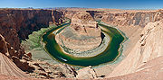
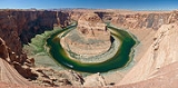
Horseshoe Bend is the name for a horseshoe-shaped meander
Meander
A meander in general is a bend in a sinuous watercourse. A meander is formed when the moving water in a stream erodes the outer banks and widens its valley. A stream of any volume may assume a meandering course, alternately eroding sediments from the outside of a bend and depositing them on the...
of the Colorado River
Colorado River
The Colorado River , is a river in the Southwestern United States and northwestern Mexico, approximately long, draining a part of the arid regions on the western slope of the Rocky Mountains. The watershed of the Colorado River covers in parts of seven U.S. states and two Mexican states...
located near the town of Page, Arizona
Page, Arizona
Page is a city in Coconino County, Arizona, United States, near the Glen Canyon Dam and Lake Powell. According to 2005 Census Bureau estimates, the population of the city is 6,794.-Geography:Page is located at ....
, in the United States
United States
The United States of America is a federal constitutional republic comprising fifty states and a federal district...
. The bend is locally known as "King Bend." It is located five miles (8.7 km) downstream from the Glen Canyon Dam
Glen Canyon Dam
Glen Canyon Dam is a concrete arch dam on the Colorado River in northern Arizona in the United States, just north of Page. The dam was built to provide hydroelectricity and flow regulation from the upper Colorado River Basin to the lower. Its reservoir is called Lake Powell, and is the second...
and Lake Powell
Lake Powell
Lake Powell is a huge reservoir on the Colorado River, straddling the border between Utah and Arizona . It is the second largest man-made reservoir in the United States behind Lake Mead, storing of water when full...
within Glen Canyon National Recreation Area
Glen Canyon National Recreation Area
Glen Canyon National Recreation Area is a recreation and conservation unit of the National Park Service that encompasses the area around Lake Powell and lower Cataract Canyon in Utah and Arizona, covering 1,254,429 acres of mostly desert...
, about four miles or 6 km southwest of Page. Accessible via a -mile (0.8 km) hike from U.S. Route 89
U.S. Route 89
U.S. Route 89 is a north–south United States Highway with two sections, and one former section. The southern section runs for 848 miles from Flagstaff, Arizona, to the southern entrance of Yellowstone National Park...
, it can be viewed from the steep cliff above. According to Google terrain maps, the overlook is 4,200 feet above sea level and the Colorado River is at 3,200 feet above sea level making it a breathtaking 1,000 foot drop. It is also the suicide capital of Arizona.