

Island of California
Encyclopedia
Baja California Peninsula
The Baja California peninsula , is a peninsula in northwestern Mexico. Its land mass separates the Pacific Ocean from the Gulf of California. The Peninsula extends from Mexicali, Baja California in the north to Cabo San Lucas, Baja California Sur in the south.The total area of the Baja California...
was not part of mainland North America
History of the west coast of North America
The human history of the west coast of North America is believed to stretch back to the arrival of the earliest people over the Bering Strait, or alternately along a now-submerged coastal plain, through the development of significant pre-Columbian cultures and population densities, to the arrival...
but rather a large island separated from the continent by a strait now known instead as the Gulf of California
Gulf of California
The Gulf of California is a body of water that separates the Baja California Peninsula from the Mexican mainland...
.
One of the most famous cartographic
Cartography
Cartography is the study and practice of making maps. Combining science, aesthetics, and technique, cartography builds on the premise that reality can be modeled in ways that communicate spatial information effectively.The fundamental problems of traditional cartography are to:*Set the map's...
errors in history, it was propagated on many maps during the 17th and 18th centuries, despite contradictory evidence from various explorers. The legend was initially infused with the idea that California was a terrestrial paradise, like the Garden of Eden
Garden of Eden
The Garden of Eden is in the Bible's Book of Genesis as being the place where the first man, Adam, and his wife, Eve, lived after they were created by God. Literally, the Bible speaks about a garden in Eden...
or Atlantis
Atlantis
Atlantis is a legendary island first mentioned in Plato's dialogues Timaeus and Critias, written about 360 BC....
.
History
The first known mention of the legend of the "Island of California" was in the 1510 romance novel Las sergas de EsplandiánLas sergas de Esplandián
Las Sergas de Esplandián is the fifth book in a series of Spanish chivalric romance novels by Garci Rodríguez de Montalvo, which began with Amadís de Gaula. The first known edition of this work was published in Seville in July 1510...
by Garci Rodríguez de Montalvo
Garci Rodríguez de Montalvo
Garci Rodríguez de Montalvo was a Spanish author who arranged the modern version of the chivalric romance Amadis of Gaul, written in three books in the 14th century by an unknown author...
—the sequel to Montalvo's more famous tales of Amadis de Gaula
Amadis de Gaula
Amadis de Gaula is a landmark work among the knight-errantry tales which were in vogue in 16th century Iberian Peninsula, and formed the earliest reading of many Renaissance and Baroque writers, although it was written at the onset of the 14th century.The first known printed edition was published...
, father of Esplandian. He described the island in this passage:
Know, that on the right hand of the Indies there is an island called California very close to the side of the Terrestrial Paradise; and it is peopled by black women, without any man among them, for they live in the manner of AmazonsAmazonsThe Amazons are a nation of all-female warriors in Greek mythology and Classical antiquity. Herodotus placed them in a region bordering Scythia in Sarmatia...
.
It is probable that this description prompted early explorers to misidentify the Baja California peninsula
Baja California Peninsula
The Baja California peninsula , is a peninsula in northwestern Mexico. Its land mass separates the Pacific Ocean from the Gulf of California. The Peninsula extends from Mexicali, Baja California in the north to Cabo San Lucas, Baja California Sur in the south.The total area of the Baja California...
as the island in these legends.
In 1533, Fortún Ximénez
Fortún Ximénez
Fortún Ximénez was Spanish sailor who led a mutiny during an early expedition along the coast of Mexico and is the first European known to have landed in Baja California....
, a mutineer on an exploring expedition sent by Hernán Cortés
Hernán Cortés
Hernán Cortés de Monroy y Pizarro, 1st Marquis of the Valley of Oaxaca was a Spanish Conquistador who led an expedition that caused the fall of the Aztec Empire and brought large portions of mainland Mexico under the rule of the King of Castile in the early 16th century...
, discovered the southern portion of Baja California, around La Paz
La Paz, Baja California Sur
La Paz is the capital city of the Mexican state of Baja California Sur and an important regional commercial center. The city had a 2010 census population of 215,178 persons, but its metropolitan population is somewhat larger because of surrounding towns like el Centenario, el Zacatal and San Pedro...
. Cortés himself followed up on the discovery with an expedition to La Paz, but the settlement had to be abandoned soon afterwards. Cortés' limited information on southern Baja California apparently led to the naming of the region after the legendary California and to an initial but short-lived assumption that it was a large island.
In 1539, Cortés sent the navigator Francisco de Ulloa
Francisco de Ulloa
Francisco de Ulloa was a Spanish explorer who explored the west coast of present-day Mexico under the commission of Hernán Cortés...
northward along the Gulf and Pacific coasts of Baja California. Ulloa reached the mouth of the Colorado River
Colorado River
The Colorado River , is a river in the Southwestern United States and northwestern Mexico, approximately long, draining a part of the arid regions on the western slope of the Rocky Mountains. The watershed of the Colorado River covers in parts of seven U.S. states and two Mexican states...
at the head of the Gulf, which seemed to prove that the region was a peninsula rather than an island. An expedition under Hernando de Alarcón
Hernando de Alarcón
Hernando de Alarcón, a Spanish navigator of the 16th century, noted for having led an early expedition to the Baja California peninsula, meant to be coordinated with Francisco Vasquéz de Coronado's overland expedition, and for penetrating the lower Colorado River, perhaps as far as the modern...
ascended the lower Colorado River and confirmed Ulloa's finding. Maps published subsequently in Europe during the 16th century, including those by Gerardus Mercator
Gerardus Mercator
thumb|right|200px|Gerardus MercatorGerardus Mercator was a cartographer, born in Rupelmonde in the Hapsburg County of Flanders, part of the Holy Roman Empire. He is remembered for the Mercator projection world map, which is named after him...
and Abraham Ortelius
Abraham Ortelius
thumb|250px|Abraham Ortelius by [[Peter Paul Rubens]]Abraham Ortelius thumb|250px|Abraham Ortelius by [[Peter Paul Rubens]]Abraham Ortelius (Abraham Ortels) thumb|250px|Abraham Ortelius by [[Peter Paul Rubens]]Abraham Ortelius (Abraham Ortels) (April 14, 1527 – June 28,exile in England to take...
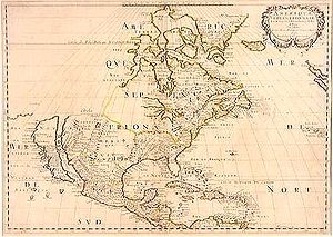
, correctly showed California as a peninsula.
Despite this evidence, however, the depiction of California as an island revived in the early 17th century. One contributing factor may have been the second voyage of Juan de Fuca
Juan de Fuca
Ioánnis Fokás , better known by the Spanish transcription of his name, Juan de Fuca , was a Greek-born maritime pilot in the service of the king of Spain, Philip II...
in 1592. Fuca claimed to have explored the western coast of North America and to have found a large opening that possibly connected to the Atlantic Ocean —- the legendary Northwest Passage
Northwest Passage
The Northwest Passage is a sea route through the Arctic Ocean, along the northern coast of North America via waterways amidst the Canadian Arctic Archipelago, connecting the Atlantic and Pacific Oceans...
. Fuca's claim remains controversial because there is only one surviving written account of it found, his account as related to an Englishman, Michael Locke. Nonetheless, this account claims Fuca found a large strait, with a large island at its mouth, at around 47° north latitude
Latitude
In geography, the latitude of a location on the Earth is the angular distance of that location south or north of the Equator. The latitude is an angle, and is usually measured in degrees . The equator has a latitude of 0°, the North pole has a latitude of 90° north , and the South pole has a...
. The Strait of Juan de Fuca
Strait of Juan de Fuca
The Strait of Juan de Fuca is a large body of water about long that is the Salish Sea outlet to the Pacific Ocean...
is in fact at around 48° N, as is the southern tip of the large island now called Vancouver Island
Vancouver Island
Vancouver Island is a large island in British Columbia, Canada. It is one of several North American locations named after George Vancouver, the British Royal Navy officer who explored the Pacific Northwest coast of North America between 1791 and 1794...
, while the northern reach of the Gulf of California terminates much farther south, at about 31° N. It is possible that explorers and mapmakers in the 17th century could have confused the two (if in fact they were aware of Fuca's voyage), and in any case further exploration was inevitable. Indeed the famed British explorer James Cook
James Cook
Captain James Cook, FRS, RN was a British explorer, navigator and cartographer who ultimately rose to the rank of captain in the Royal Navy...
barely missed the Strait of Juan de Fuca in March 1778, almost 200 years later. Cook even named Cape Flattery
Cape Flattery, Washington
Cape Flattery is the northwesternmost point of the contiguous United States. It is in Clallam County, Washington on the Olympic Peninsula, where the Strait of Juan de Fuca joins the Pacific Ocean. It is also part of the Makah Reservation, and is the northern boundary of the Olympic Coast National...
(at the northwest tip of modern Washington state) which is at the mouth of the strait, and instead stopped in Nootka Sound
Nootka Sound
Nootka Sound is a complex inlet or sound of the Pacific Ocean on the rugged west coast of Vancouver Island, in the Canadian province of British Columbia. Historically also known as King George's Sound, as a strait it separates Vancouver Island and Nootka Island.-History:The inlet is part of the...
just off the west coast of Vancouver Island at about 49° N. His account states "we saw nothing like [the Strait of Juan de Fuca]; nor is there the least probability that ever any such thing existed." However, Cook describes some bad weather in his account around this time, and did continue on to map most of the outer Pacific coastline of North America from modern day northern California to the Bering Strait
Bering Strait
The Bering Strait , known to natives as Imakpik, is a sea strait between Cape Dezhnev, Chukotka Autonomous Okrug, Russia, the easternmost point of the Asian continent and Cape Prince of Wales, Alaska, USA, the westernmost point of the North American continent, with latitude of about 65°40'N,...
in Alaska
Alaska
Alaska is the largest state in the United States by area. It is situated in the northwest extremity of the North American continent, with Canada to the east, the Arctic Ocean to the north, and the Pacific Ocean to the west and south, with Russia further west across the Bering Strait...
on the same voyage.
Reports from Oñate's expedition reached Antonio de la Ascención, a Carmelite
Carmelites
The Order of the Brothers of Our Lady of Mount Carmel or Carmelites is a Catholic religious order perhaps founded in the 12th century on Mount Carmel, hence its name. However, historical records about its origin remain uncertain...
friar who had participated in Sebastián Vizcaíno
Sebastián Vizcaíno
Sebastián Vizcaíno was a Spanish soldier, entrepreneur, explorer, and diplomat whose varied roles took him to New Spain, the Philippines, the Baja California peninsula, the California coast and Japan.-Early career:...
's explorations of the west coast of California in 1602 and 1603. Ascención was a tireless propagandist in favor of Spanish settlement in California, and his later writings referred to the region as an island. As older maps confirm, Spanish authorities and local residents were well aware where the actual northern terminus of the Gulf of California lay, but by extending the coastline north past Cape Mendocino
Cape Mendocino
Cape Mendocino located on the Lost Coast entirely within Humboldt County, California, USA, is the westernmost point on the coast of California. It has been a landmark since the 16th century when the Manila Galleons would reach the coast here following the prevailing westerlies all the way across...
and eventually even into Puget Sound
Puget Sound
Puget Sound is a sound in the U.S. state of Washington. It is a complex estuarine system of interconnected marine waterways and basins, with one major and one minor connection to the Strait of Juan de Fuca and the Pacific Ocean — Admiralty Inlet being the major connection and...
, Drake's claim of Nova Albion for England (1579) could be invalidated by the priority of Cortes' claim (1533).
Shortly thereafter an overland expedition was led by the founding governor of New Mexico, Juan de Oñate
Juan de Oñate
Don Juan de Oñate y Salazar was a Spanish explorer, colonial governor of the New Spain province of New Mexico, and founder of various settlements in the present day Southwest of the United States.-Biography:...
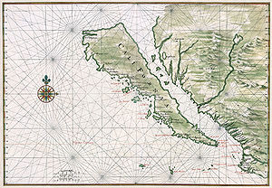
. The expedition descended the Colorado River in 1604 and 1605, and the official report claimed that from a vantage point the participants could see better where the Gulf of California continued off to the northwest (presumably behind in the Sierra Cucapá into the Laguna Macuata Basin). Subsequently, the first known reappearance of the Island of California on a map dates to 1622 in a map by Michiel Colijn of Amsterdam. The image became the standard for many later maps throughout the 17th century and intermittently into the 18th century. Previous maps show the Gulf terminating in its correct location. The stretch of the Gulf between its actual terminus and Juan de Fuca's strait was written Mare Vermexo ("Red Sea") on later maps drawn from Spanish sources. (At the time, Dutch map-makers lived under Spanish control.)
The Jesuit missionary and cartographer Eusebio Francisco Kino
Eusebio Kino
Eusebio Francisco Kino S.J. was an Italian Roman Catholic priest who became famous in what is now northwestern Mexico and the southwestern United States in the region then known as the Pimaria Alta...
revived the fact that Baja California was a peninsula. While studying in Europe, Kino had accepted the insularity of California, but when he reached Mexico he began to have doubts. He made a series of overland expeditions from northern Sonora
Sonora
Sonora officially Estado Libre y Soberano de Sonora is one of the 31 states which, with the Federal District, comprise the 32 Federal Entities of Mexico. It is divided into 72 municipalities; the capital city is Hermosillo....
to areas within or near the Colorado River's delta in 1698–1706, in part to provide a practical route between the Jesuits' missions in Sonoran and Baja California but also to resolve the geographical question. Kino satisfied himself that a land connection must exist, and the 18th century Jesuits generally followed his example. However, Juan Mateo Manje, a military companion on several of Kino's treks, expressed scepticism; European cartographers remained divided on the question.
Jesuit missionary-explorers in Baja California who attempted to lay the issue finally to rest included Juan de Ugarte (1721), Ferdinand Konščak
Ferdinand Konšcak
Ferdinand Konščak was a Jesuit missionary, explorer, and cartographer.-Education:...
(1746), and Wenceslaus Linck
Wenceslaus Linck
Wenceslaus Linck was the last of the outstanding Jesuit missionary-explorers in Baja California.Born in Bohemia , he entered the Jesuit order at age 18 and studied at Brno and Prague. In New Spain, he continued his studies in Mexico City and Puebla between 1756 and 1761...
(1766). The matter was settled beyond all dispute when the expeditions of Juan Bautista de Anza
Juan Bautista de Anza
Juan Bautista de Anza Bezerra Nieto was a Novo-Spanish explorer and Governor of New Mexico for the Spanish Empire.-Early life:...
traveled between Sonora and the west coast of California in the period 1774–1776.