
Marble Canyon
Encyclopedia
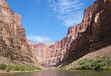
Marble Canyon is the section of the Colorado River canyon in northern Arizona
from Lee's Ferry
to the confluence with the Little Colorado River
, which marks the beginning of the Grand Canyon
.
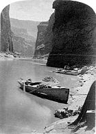
Lee's Ferry
is a common launching point for river runners starting their journey through the Grand Canyon. Marble Canyon is also well-known for the Navajo Bridge
, where US Highway 89A crosses the Colorado River.
Marble Canyon marks the western boundary of the Navajo Nation
. In 1975, the former Marble Canyon National Monument, which followed the Colorado River northeast from the Grand Canyon to Lee's Ferry, was made part of Grand Canyon National Park
.
 Marble Canyon is the site of one of the last great proposed dam projects on the Colorado. Proposed and investigated in the early 1950s, the proposal met substantial opposition, notably from the Sierra Club
, when it was considered as part of the Central Arizona Project from 1965 to 1968. The proposed dam was abandoned in 1968. Exploratory holes, which were drilled in the Redwall Limestone of the canyon walls in an early phase of the abortive project, can still be seen at Mile 39.2.
Arizona
Arizona ; is a state located in the southwestern region of the United States. It is also part of the western United States and the mountain west. The capital and largest city is Phoenix...
from Lee's Ferry
Lee's Ferry
Lee's Ferry is a site on the Colorado River in Coconino County, Arizona, United States, about 7.5 miles southwest of the town of Page, Arizona and the Glen Canyon Dam, and about 9 mi south of the Utah-Arizona border. It is the former location of a ferry established by John D. Lee, a Mormon...
to the confluence with the Little Colorado River
Little Colorado River
The Little Colorado River is a river in the U.S. state of Arizona, providing the principal drainage from the Painted Desert region. Together with its major tributary, the Puerco River, it drains an area of about in eastern Arizona and western New Mexico...
, which marks the beginning of the Grand Canyon
Grand Canyon
The Grand Canyon is a steep-sided canyon carved by the Colorado River in the United States in the state of Arizona. It is largely contained within the Grand Canyon National Park, the 15th national park in the United States...
.
Lee's Ferry
Lee's Ferry
Lee's Ferry is a site on the Colorado River in Coconino County, Arizona, United States, about 7.5 miles southwest of the town of Page, Arizona and the Glen Canyon Dam, and about 9 mi south of the Utah-Arizona border. It is the former location of a ferry established by John D. Lee, a Mormon...
is a common launching point for river runners starting their journey through the Grand Canyon. Marble Canyon is also well-known for the Navajo Bridge
Navajo Bridge
Navajo Bridge crosses the Colorado River's Marble Canyon near Lee's Ferry in the US state of Arizona. Apart from the Glen Canyon Bridge a few miles upstream at Page, Arizona, it is the only roadway crossing of the river and the Grand Canyon for nearly...
, where US Highway 89A crosses the Colorado River.
Marble Canyon marks the western boundary of the Navajo Nation
Navajo Nation
The Navajo Nation is a semi-autonomous Native American-governed territory covering , occupying all of northeastern Arizona, the southeastern portion of Utah, and northwestern New Mexico...
. In 1975, the former Marble Canyon National Monument, which followed the Colorado River northeast from the Grand Canyon to Lee's Ferry, was made part of Grand Canyon National Park
Grand Canyon National Park
Grand Canyon National Park is the United States' 15th oldest national park and is located in Arizona. Within the park lies the Grand Canyon, a gorge of the Colorado River, considered to be one of the Wonders of the World. The park covers of unincorporated area in Coconino and Mohave counties.Most...
.
Sierra Club
The Sierra Club is the oldest, largest, and most influential grassroots environmental organization in the United States. It was founded on May 28, 1892, in San Francisco, California, by the conservationist and preservationist John Muir, who became its first president...
, when it was considered as part of the Central Arizona Project from 1965 to 1968. The proposed dam was abandoned in 1968. Exploratory holes, which were drilled in the Redwall Limestone of the canyon walls in an early phase of the abortive project, can still be seen at Mile 39.2.