

Transverse Ranges
Encyclopedia
The Transverse Ranges are a group of mountain ranges of southern California
, in the Pacific Coast Ranges
physiographic region
that runs along the Pacific
coast from Alaska
to Mexico
in North America
. The Transverse Ranges begin at the southern end of the California Coast Ranges and lie between Santa Barbara
and San Diego counties. They derive the name Transverse Ranges due to their East-West orientation, making them transverse to the general North-South orientation of most of California's coastal mountains.
stemming from the interaction of the Pacific Plate
and the North American Plate
along the San Andreas Fault
system. Their orientation along an east-west axis as opposed to the general southeast-northwest trend of most California ranges results from a pronounced step in the San Andreas Fault, the cause of which is a subject of intensive ongoing study. The San Andreas Fault is a Dextral
Strike-Slip Fault with a right step, causing the mountains. Their elevation is somewhat better understood as a consequence of this step. The crust atop the Pacific Plate south of the ranges does not easily make the turn westward as the entire plate moves northwestward, forcing pieces of the crust to compress and lift.
The crust which comprises the Transverse Ranges is part of what is known as the Salinian Block
, originally a piece of the North American Plate which was broken off what is now northwestern Mexico as the Gulf of California
rifted open.
Physiographically, the Tranverse Ranges are a distinct physiographic section of the larger Pacific Border province, which in turn is part of the larger Pacific Mountain System. They exhibit extreme differences in geologic age and composition, varying from sedimentary rocks in the western Santa Ynez and Santa Monica mountains to primarily granitic and metamorphic rock in the eastern regions, where they terminate abruptly in the San Gabriel and San Bernardino mountains.
to the south. They begin at Point Conception in Santa Barbara County, and include the Santa Ynez Mountains
that run parallel to the coast behind Santa Barbara
. Also in Santa Barbara County, they include the San Rafael Mountains
and the Sierra Madre Mountains
, both of which extend approximately to the Ventura County line. The Transverse Ranges also include the Topatopa Mountains
and the Santa Susana Mountains
of Ventura County and Los Angeles County, the Simi Hills
, the Santa Monica Mountains
that run along the Pacific coast behind Malibu, and whose eastern portion are known as the Hollywood Hills
, and the Chalk Hills
.
The Ranges include the steep San Gabriel Mountains
northeast of Los Angeles
, the San Rafael Hills
, Puente Hills
, San Jose Hills
, and Chino Hills
, and the San Bernardino Mountains
. To the north of the Transverse ranges are the Central Coast Ranges, The Central Valley, and the Tehachapi Mountains
, which separate the Central Valley from the Mojave Desert
to the east, and link the Transverse ranges to the Sierra Nevada. The Mojave Desert and California's low desert, including the Coachella Valley
, are at the eastern end of the ranges. The northern Channel Islands of California
are also part of the Transverse Ranges; San Miguel
, Santa Rosa
, Santa Cruz
and Anacapa Island
s are a westward extension of the Santa Monica Mountains.
Mountain and hill ranges in the Transverse Ranges:
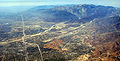 There are a number of important freeways that cross the Transverse Ranges, like (from west to east) US-101, I-5 at Tejon Pass
, SR 14
at Soledad Pass, and I-15 at Cajon Pass
. These highways link Southern California
with places to the north and northeast like San Francisco and Las Vegas
, respectively. With the exception of several high passes on less-traveled SR 33
, SR 2, SR 330
. SR 18 and SR 38
, none of these passes are at high elevations, with Cajon Pass being at a modest 4,190 ft (1,277 m) above mean sea level
; this means that snow
is less of a factor here than in the moderate to high mountain passes to the north like Donner Pass
. Still sometimes, heavy snowfall can snarl traffic on Tejon and Cajon Pass, the higher two of the three freeway passes. I-5 and I-15 commonly experience heavy traffic over their mountainous route across these mountains.
, chaparral
(lower chaparral, upper chaparral, and desert chaparral), oak woodland and savanna
, and pinyon-juniper woodland at lower elevations, and yellow pine forest, Lodgepole Pine
forest, and subalpine forest at higher elevations. The Angeles
and Los Padres National Forest
s cover portions of the Transverse ranges. The ranges are part of the California chaparral and woodlands
ecoregion
, but the eastern ends of the range touch two desert ecoregions, the Mojave Desert
and the Colorado Desert
section of the Sonoran Desert
. The Carrizo Plain
adjoins the northern edge of the Transverse Range.
Chaparral is a common feature of the Transverse Ranges. Common plant associates in chaparral
, especially in the transition between coastal chaparral and coastal sage scrub, include California sagebrush and Toyon
, the latter shrub having its southern distribution limit defined by the Transverse Ranges.
of coastal Ventura County, the Santa Clarita Valley
north of Los Angeles, the San Fernando Valley
, which is mostly included in the City of Los Angeles. The Los Angeles Basin, which includes the portion of Los Angeles County south of the Santa Monica Mountains and most of Orange County
, and the Inland Empire
basin, which includes the cities of San Bernardino
and Riverside
, lie between the Transverse Ranges and the Peninsular Ranges to the south.
California
California is a state located on the West Coast of the United States. It is by far the most populous U.S. state, and the third-largest by land area...
, in the Pacific Coast Ranges
Pacific Coast Ranges
The Pacific Coast Ranges and the Pacific Mountain System are the series of mountain ranges that stretch along the West Coast of North America from Alaska south to Northern and Central Mexico...
physiographic region
Physiographic regions of the world
The physiographic regions of the world are a means of defining the Earth's landforms into distinct regions based upon classic 1916 three-tiered approach defining divisions, provinces, and sections...
that runs along the Pacific
Pacific Ocean
The Pacific Ocean is the largest of the Earth's oceanic divisions. It extends from the Arctic in the north to the Southern Ocean in the south, bounded by Asia and Australia in the west, and the Americas in the east.At 165.2 million square kilometres in area, this largest division of the World...
coast from Alaska
Alaska
Alaska is the largest state in the United States by area. It is situated in the northwest extremity of the North American continent, with Canada to the east, the Arctic Ocean to the north, and the Pacific Ocean to the west and south, with Russia further west across the Bering Strait...
to Mexico
Mexico
The United Mexican States , commonly known as Mexico , is a federal constitutional republic in North America. It is bordered on the north by the United States; on the south and west by the Pacific Ocean; on the southeast by Guatemala, Belize, and the Caribbean Sea; and on the east by the Gulf of...
in North America
North America
North America is a continent wholly within the Northern Hemisphere and almost wholly within the Western Hemisphere. It is also considered a northern subcontinent of the Americas...
. The Transverse Ranges begin at the southern end of the California Coast Ranges and lie between Santa Barbara
Santa Barbara, California
Santa Barbara is the county seat of Santa Barbara County, California, United States. Situated on an east-west trending section of coastline, the longest such section on the West Coast of the United States, the city lies between the steeply-rising Santa Ynez Mountains and the Pacific Ocean...
and San Diego counties. They derive the name Transverse Ranges due to their East-West orientation, making them transverse to the general North-South orientation of most of California's coastal mountains.
Geology
The Transverse Ranges represent a complex of tectonic forces and faultingSouthern California faults
Most of central and northern California rests on a crustal block that is being torn from the North American continent by the passing Pacific plate of oceanic crust...
stemming from the interaction of the Pacific Plate
Pacific Plate
The Pacific Plate is an oceanic tectonic plate that lies beneath the Pacific Ocean. At 103 million square kilometres, it is the largest tectonic plate....
and the North American Plate
North American Plate
The North American Plate is a tectonic plate covering most of North America, Greenland, Cuba, Bahamas, and parts of Siberia, Japan and Iceland. It extends eastward to the Mid-Atlantic Ridge and westward to the Chersky Range in eastern Siberia. The plate includes both continental and oceanic crust...
along the San Andreas Fault
San Andreas Fault
The San Andreas Fault is a continental strike-slip fault that runs a length of roughly through California in the United States. The fault's motion is right-lateral strike-slip...
system. Their orientation along an east-west axis as opposed to the general southeast-northwest trend of most California ranges results from a pronounced step in the San Andreas Fault, the cause of which is a subject of intensive ongoing study. The San Andreas Fault is a Dextral
Sinistral
Sinistral and dextral are scientific terms that describe chirality or relative direction in a number of disciplines.The terms are derived from the Latin words for “left” and “right” ....
Strike-Slip Fault with a right step, causing the mountains. Their elevation is somewhat better understood as a consequence of this step. The crust atop the Pacific Plate south of the ranges does not easily make the turn westward as the entire plate moves northwestward, forcing pieces of the crust to compress and lift.
The crust which comprises the Transverse Ranges is part of what is known as the Salinian Block
Salinian Block
The Salinian Block or Salinian terrane is a geologic terrane which lies west of the main trace of the San Andreas Fault system in California. It is bounded on the south by the Big Pine Fault in Ventura County, and on the west by the Nacimiento Fault...
, originally a piece of the North American Plate which was broken off what is now northwestern Mexico as the Gulf of California
Gulf of California
The Gulf of California is a body of water that separates the Baja California Peninsula from the Mexican mainland...
rifted open.
Physiographically, the Tranverse Ranges are a distinct physiographic section of the larger Pacific Border province, which in turn is part of the larger Pacific Mountain System. They exhibit extreme differences in geologic age and composition, varying from sedimentary rocks in the western Santa Ynez and Santa Monica mountains to primarily granitic and metamorphic rock in the eastern regions, where they terminate abruptly in the San Gabriel and San Bernardino mountains.
Ranges
The Transverse ranges run predominantly east-west, while the other coast ranges tend north-south, including the Central Coast Ranges to the north and the Peninsular RangesPeninsular Ranges
The Peninsular Ranges are a group of mountain ranges, in the Pacific Coast Ranges, which stretch from southern California in the United States to the southern tip of Mexico's Baja California peninsula; they are part of the North American Coast Ranges that run along the Pacific coast from Alaska...
to the south. They begin at Point Conception in Santa Barbara County, and include the Santa Ynez Mountains
Santa Ynez Mountains
The Santa Ynez Mountains are a portion of the Transverse Ranges, part of the Pacific Coast Ranges of the west coast of North America, and are one of the northernmost mountain ranges in Southern California.-Geography:...
that run parallel to the coast behind Santa Barbara
Santa Barbara, California
Santa Barbara is the county seat of Santa Barbara County, California, United States. Situated on an east-west trending section of coastline, the longest such section on the West Coast of the United States, the city lies between the steeply-rising Santa Ynez Mountains and the Pacific Ocean...
. Also in Santa Barbara County, they include the San Rafael Mountains
San Rafael Mountains
The San Rafael Mountains are a mountain range in central Santa Barbara County, California, U.S.. They are part of the Transverse Ranges system of Southern California which in turn are part of the Pacific Coast Ranges system of western North America....
and the Sierra Madre Mountains
Sierra Madre Mountains (California)
The Sierra Madre Mountains are a mountain range in northern Santa Barbara County, California, USA. They are a portion of the Inner South Coast Ranges, representing the southernmost part, which are themselves part of the Pacific Coast Ranges of western North America. The Sierra Madre Mountains...
, both of which extend approximately to the Ventura County line. The Transverse Ranges also include the Topatopa Mountains
Topatopa Mountains
The Topatopa Mountains are a mountain range in Ventura County, California, north of Santa Paula. They are part of the Transverse Ranges of Southern California. The range lies in an east-west direction northeast of the community of Ojai, and west of the Sespe Condor Sanctuary. The ranges reaches an...
and the Santa Susana Mountains
Santa Susana Mountains
The Santa Susana Mountains are a transverse range of mountains in southern California, north of the city of Los Angeles, in the United States. The range runs east-west separating the San Fernando Valley and Simi Valley on its south, from Santa Clara River Valley to the north, and Santa Clarita...
of Ventura County and Los Angeles County, the Simi Hills
Simi Hills
The Simi Hills are a low rocky mountain range of the Transverse Ranges, located in eastern Ventura County and western Los Angeles County, of southern California, United States.-Geography:...
, the Santa Monica Mountains
Santa Monica Mountains
The Santa Monica Mountains are a Transverse Range in Southern California, along the coast of the Pacific Ocean in the United States.-Geography:...
that run along the Pacific coast behind Malibu, and whose eastern portion are known as the Hollywood Hills
Hollywood Hills
The Hollywood Hills is an affluent and exclusive neighborhood of Los Angeles, California, in the southeastern Santa Monica Mountains. It is bound by Laurel Canyon Boulevard to the west, Vermont Avenue to the east, Mulholland Drive to the north, and Sunset Boulevard to the south.-Hollywood Hills...
, and the Chalk Hills
Chalk Hills
The Chalk Hills are a north—south running low 'mountain' range in the San Fernando Valley perpendicular to and adjoining the Santa Monica Mountains. They are located in the Woodland Hills District of the City of Los Angeles in Southern California.-Environs:...
.
The Ranges include the steep San Gabriel Mountains
San Gabriel Mountains
The San Gabriel Mountains Range is located in northern Los Angeles County and western San Bernardino County, California, United States. The mountain range lies between the Los Angeles Basin and the Mojave Desert, with Interstate 5 to the west and Interstate 15 to the east...
northeast of Los Angeles
Los Angeles, California
Los Angeles , with a population at the 2010 United States Census of 3,792,621, is the most populous city in California, USA and the second most populous in the United States, after New York City. It has an area of , and is located in Southern California...
, the San Rafael Hills
San Rafael Hills
The San Rafael Hills are a mountain range in Los Angeles County, California. They are one of the lower Transverse Ranges, and are parallel to and below the San Gabriel Mountains to the south, adjacent to the San Gabriel Valley overlooking the Los Angeles Basin.-Geography:The Hills contain all or...
, Puente Hills
Puente Hills
The Puente Hills is a chain of hills, one of the lower Transverse Ranges, in an unincorporated area in eastern Los Angeles County, California.-Geography:...
, San Jose Hills
San Jose Hills
The San Jose Hills are a part of the Transverse Ranges located in Eastern Los Angeles County, California, marking the border between the San Gabriel Valley and the Pomona Valley in the Inland Empire. It includes portions of Covina, West Covina, Walnut, Pomona, and San Dimas.- Geology :The San Jose...
, and Chino Hills
Chino Hills
The Chino Hills are a mountain range on the border of Orange, Los Angeles, and San Bernardino Counties, California, with a small portion in Riverside County...
, and the San Bernardino Mountains
San Bernardino Mountains
The San Bernardino Mountains are a short transverse mountain range north and east of San Bernardino in Southern California in the United States. The mountains run for approximately 60 miles east-west on the southern edge of the Mojave Desert in southwestern San Bernardino County, north of the...
. To the north of the Transverse ranges are the Central Coast Ranges, The Central Valley, and the Tehachapi Mountains
Tehachapi Mountains
The Tehachapi Mountains , regionally also called The Tehachapis, are a mountain range in the Transverse Ranges system of California in the Western United States...
, which separate the Central Valley from the Mojave Desert
Mojave Desert
The Mojave Desert occupies a significant portion of southeastern California and smaller parts of central California, southern Nevada, southwestern Utah and northwestern Arizona, in the United States...
to the east, and link the Transverse ranges to the Sierra Nevada. The Mojave Desert and California's low desert, including the Coachella Valley
Coachella Valley
Coachella Valley is a large valley landform in Southern California. The valley extends for approximately 45 miles in Riverside County southeast from the San Bernardino Mountains to the saltwater Salton Sea, the largest lake in California...
, are at the eastern end of the ranges. The northern Channel Islands of California
Channel Islands of California
The Channel Islands of California are a chain of eight islands located in the Pacific Ocean off the coast of Southern California along the Santa Barbara Channel in the United States of America...
are also part of the Transverse Ranges; San Miguel
San Miguel Island
San Miguel Island is the westernmost of California's Channel Islands, located across the Santa Barbara Channel in the Pacific Ocean, within Santa Barbara County, California. San Miguel is the sixth-largest of the eight Channel Islands at , including offshore islands and rocks. Prince Island, off...
, Santa Rosa
Santa Rosa Island, California
Santa Rosa Island is the second largest of the Channel Islands of California at 53,195 acres . Defined by the United States Census Bureau as Block 3009, Block Group 3, Census Tract 29.10 of Santa Barbara County, California, the 2000 census showed an official population of 2 persons. It is part of...
, Santa Cruz
Santa Cruz Island
Santa Cruz Island was the largest privately owned island off the continental United States, but is currently part-owned by the National Park service . The island, located off the coast of California, is long and from wide...
and Anacapa Island
Anacapa Island
Anacapa Island is a small volcanic island located about off the coast of Port Hueneme, California, in Ventura County. The Island is composed of a series of narrow islets six miles long, running in a mostly east-west orientation, five miles east of Santa Cruz Island...
s are a westward extension of the Santa Monica Mountains.
Mountain and hill ranges in the Transverse Ranges:
- Santa Ynez MountainsSanta Ynez MountainsThe Santa Ynez Mountains are a portion of the Transverse Ranges, part of the Pacific Coast Ranges of the west coast of North America, and are one of the northernmost mountain ranges in Southern California.-Geography:...
- San Rafael MountainsSan Rafael MountainsThe San Rafael Mountains are a mountain range in central Santa Barbara County, California, U.S.. They are part of the Transverse Ranges system of Southern California which in turn are part of the Pacific Coast Ranges system of western North America....
- Sierra Madre MountainsSierra Madre Mountains (California)The Sierra Madre Mountains are a mountain range in northern Santa Barbara County, California, USA. They are a portion of the Inner South Coast Ranges, representing the southernmost part, which are themselves part of the Pacific Coast Ranges of western North America. The Sierra Madre Mountains...
- Topatopa MountainsTopatopa MountainsThe Topatopa Mountains are a mountain range in Ventura County, California, north of Santa Paula. They are part of the Transverse Ranges of Southern California. The range lies in an east-west direction northeast of the community of Ojai, and west of the Sespe Condor Sanctuary. The ranges reaches an...
- Santa Susana MountainsSanta Susana MountainsThe Santa Susana Mountains are a transverse range of mountains in southern California, north of the city of Los Angeles, in the United States. The range runs east-west separating the San Fernando Valley and Simi Valley on its south, from Santa Clara River Valley to the north, and Santa Clarita...
- Simi HillsSimi HillsThe Simi Hills are a low rocky mountain range of the Transverse Ranges, located in eastern Ventura County and western Los Angeles County, of southern California, United States.-Geography:...
- Chalk HillsChalk HillsThe Chalk Hills are a north—south running low 'mountain' range in the San Fernando Valley perpendicular to and adjoining the Santa Monica Mountains. They are located in the Woodland Hills District of the City of Los Angeles in Southern California.-Environs:...
- Santa Monica MountainsSanta Monica MountainsThe Santa Monica Mountains are a Transverse Range in Southern California, along the coast of the Pacific Ocean in the United States.-Geography:...
- San Gabriel MountainsSan Gabriel MountainsThe San Gabriel Mountains Range is located in northern Los Angeles County and western San Bernardino County, California, United States. The mountain range lies between the Los Angeles Basin and the Mojave Desert, with Interstate 5 to the west and Interstate 15 to the east...
- San Rafael HillsSan Rafael HillsThe San Rafael Hills are a mountain range in Los Angeles County, California. They are one of the lower Transverse Ranges, and are parallel to and below the San Gabriel Mountains to the south, adjacent to the San Gabriel Valley overlooking the Los Angeles Basin.-Geography:The Hills contain all or...
- Puente HillsPuente HillsThe Puente Hills is a chain of hills, one of the lower Transverse Ranges, in an unincorporated area in eastern Los Angeles County, California.-Geography:...
- San Jose HillsSan Jose HillsThe San Jose Hills are a part of the Transverse Ranges located in Eastern Los Angeles County, California, marking the border between the San Gabriel Valley and the Pomona Valley in the Inland Empire. It includes portions of Covina, West Covina, Walnut, Pomona, and San Dimas.- Geology :The San Jose...
- San Bernardino MountainsSan Bernardino MountainsThe San Bernardino Mountains are a short transverse mountain range north and east of San Bernardino in Southern California in the United States. The mountains run for approximately 60 miles east-west on the southern edge of the Mojave Desert in southwestern San Bernardino County, north of the...
- Little San Bernardino MountainsLittle San Bernardino MountainsThe Little San Bernardino Mountains are a short mountain range of the Transverse Ranges, located in southern California in the United States. They extend for approximately 40 mi southeast from the San Bernardino Mountains through San Bernardino and Riverside Counties to near the northeast...
- Tehachapi MountainsTehachapi MountainsThe Tehachapi Mountains , regionally also called The Tehachapis, are a mountain range in the Transverse Ranges system of California in the Western United States...
- Sierra Pelona MountainsSierra Pelona MountainsThe Sierra Pelona Mountains , or the Sierra Pelona Ridge, is a mountain range in the Transverse Ranges of Southern California.. They are located within Los Angeles and Kern Counties.-Geography:...
- San Emigdio MountainsSan Emigdio MountainsThe San Emigdio Mountains are a part of the Transverse Ranges in Southern California, extending from Interstate 5 at Lebec and Gorman on the east to Highway 33–166 on the west. They link the Tehachapis and Temblor Range and form the southern wall of the San Joaquin Valley.The range is within Los...
Peaks
Mountains in the Transverse Ranges, listed by height:- Mount San Gorgonio, 11,499 ft (3,505 m), San Bernardino Mountains.
- San Bernardino Peak, 10,649 ft (3,246 m), San Bernardino Mountains.
- Mount San Antonio (Old Baldy)Mount San AntonioMount San Antonio, commonly known as Old Baldy or Mt Baldy, at , is the highest peak in the San Gabriel Mountains, and the highest point in Los Angeles County...
, 10,064 ft (3,068 m), San Gabriel Mountains. - Mount PinosMount PinosMount Pinos is a mountain located in the Los Padres National Forest on the boundary between Ventura and Kern counties in California. The summit is the highest point in Ventura County.- Geography :...
, 8,831 ft (2,692 m) San Emigdio Mountains. - Frazier MountainFrazier MountainFrazier Mountain is a broad, pine-forested peak in the Transverse Ranges within the Los Padres National Forest, in Ventura County, California. At , Frazier is the fifth-highest mountain in the Transverse Ranges of Southern California....
, 8,026 ft (2,446 m) San Emigdio Mountains. - Reyes Peak, 7,510 ft (2,289 m), Pine Mountain, San Emigdio Mountains.
- Mount WilsonMount Wilson (California)Mount Wilson is one of the better known peaks in the San Gabriel Mountains, part of the Angeles National Forest in Los Angeles County, California. It is the location of the Mount Wilson Observatory and has become the astronomical center of Southern California with and telescopes, and and tall...
, 5,710 ft (1,742 m) San Gabriel Mountains. - Oat MountainOat Mountain (California)Oat Mountain is a peak of the Santa Susana Mountains overlooking the San Fernando Valley to the south and southeast. Oat Mountain is the highest peak in the Santa Susana Mountains of California. The Los Angeles district of Chatsworth is to the south of the mountain.- See also :* Mission Point*...
, 3,747 ft (1,142.1 m), Santa Susana Mountains.
Transportation
Tejon Pass
The Tejon Pass is a mountain pass at the southwest end of the Tehachapi Mountains linking Southern to Central California.-Geography:The apex of the pass is near the northwesternmost corner of Los Angeles County, north of Gorman...
, SR 14
California State Route 14
State Route 14 is a north–south state highway in the U.S. state of California, largely in the Mojave Desert. The southern portion of the highway is signed as the Antelope Valley Freeway. The route connects Interstate 5, or Golden State Freeway, near Santa Clarita and with U.S. Route 395 near...
at Soledad Pass, and I-15 at Cajon Pass
Cajon Pass
Cajon Pass is a moderate-elevation mountain pass between the San Bernardino Mountains and the San Gabriel Mountains in Southern California in the United States. It was created by the movements of the San Andreas Fault...
. These highways link Southern California
Southern California
Southern California is a megaregion, or megapolitan area, in the southern area of the U.S. state of California. Large urban areas include Greater Los Angeles and Greater San Diego. The urban area stretches along the coast from Ventura through the Southland and Inland Empire to San Diego...
with places to the north and northeast like San Francisco and Las Vegas
Las Vegas, Nevada
Las Vegas is the most populous city in the U.S. state of Nevada and is also the county seat of Clark County, Nevada. Las Vegas is an internationally renowned major resort city for gambling, shopping, and fine dining. The city bills itself as The Entertainment Capital of the World, and is famous...
, respectively. With the exception of several high passes on less-traveled SR 33
California State Route 33
State Route 33 is a north–south state highway in the U.S. state of California. SR 33 replaced part of U.S. Route 399 in 1964 during the "great renumbering" of routes. In the unincorporated sections of Kern County it is known as the West Side Highway...
, SR 2, SR 330
California State Route 330
State Route 330 is a state highway in the U.S. state of California. It is also known as City Creek Road in the San Bernardino Mountains.-Route description:...
. SR 18 and SR 38
California State Route 38
State Route 38 is a mostly rural and scenic road in the U.S. state of California. Despite the orientation of its alignment, SR 38 is assigned in a west–east direction.-Route description:...
, none of these passes are at high elevations, with Cajon Pass being at a modest 4,190 ft (1,277 m) above mean sea level
Above mean sea level
The term above mean sea level refers to the elevation or altitude of any object, relative to the average sea level datum. AMSL is used extensively in radio by engineers to determine the coverage area a station will be able to reach...
; this means that snow
Snow
Snow is a form of precipitation within the Earth's atmosphere in the form of crystalline water ice, consisting of a multitude of snowflakes that fall from clouds. Since snow is composed of small ice particles, it is a granular material. It has an open and therefore soft structure, unless packed by...
is less of a factor here than in the moderate to high mountain passes to the north like Donner Pass
Donner Pass
Donner Pass is a mountain pass in the northern Sierra Nevada, located above Donner Lake about nine miles west of Truckee, California. It has a steep approach from the east and a gradual approach from the west....
. Still sometimes, heavy snowfall can snarl traffic on Tejon and Cajon Pass, the higher two of the three freeway passes. I-5 and I-15 commonly experience heavy traffic over their mountainous route across these mountains.
Ecology
The native plant communities of the Transverse ranges include coastal sage scrubCoastal sage scrub
Coastal sage scrub is a low scrubland plant community found in the California chaparral and woodlands ecoregion of coastal California and northern Baja California. It is characterized by low-growing aromatic, and drought-deciduous shrubs adapted to the semi-arid Mediterranean climate of the...
, chaparral
Chaparral
Chaparral is a shrubland or heathland plant community found primarily in the U.S. state of California and in the northern portion of the Baja California peninsula, Mexico...
(lower chaparral, upper chaparral, and desert chaparral), oak woodland and savanna
California oak woodland
California oak woodland is a plant community found throughout the California chaparral and woodlands ecoregion of California in the United States and northwestern Baja California in Mexico...
, and pinyon-juniper woodland at lower elevations, and yellow pine forest, Lodgepole Pine
Lodgepole Pine
Lodgepole Pine, Pinus contorta, also known as Shore Pine, is a common tree in western North America. Like all pines, it is evergreen.-Subspecies:...
forest, and subalpine forest at higher elevations. The Angeles
Angeles National Forest
The Angeles National Forest of the U.S. National Forest Service is located in the San Gabriel Mountains of Los Angeles County, southern California. It was established on July 1, 1908, incorporating the first San Bernardino National Forest and parts of the former Santa Barbara and San Gabriel...
and Los Padres National Forest
Los Padres National Forest
Los Padres National Forest is a forest located in southern and central California, which includes most of the mountainous land along the California coast from Ventura to Monterey, extending inland...
s cover portions of the Transverse ranges. The ranges are part of the California chaparral and woodlands
California chaparral and woodlands
The California chaparral and woodlands is a terrestrial ecoregion of lower northern, central, and southern California and northwestern Baja California , located on the west coast of North America...
ecoregion
Ecoregion
An ecoregion , sometimes called a bioregion, is an ecologically and geographically defined area that is smaller than an ecozone and larger than an ecosystem. Ecoregions cover relatively large areas of land or water, and contain characteristic, geographically distinct assemblages of natural...
, but the eastern ends of the range touch two desert ecoregions, the Mojave Desert
Mojave Desert
The Mojave Desert occupies a significant portion of southeastern California and smaller parts of central California, southern Nevada, southwestern Utah and northwestern Arizona, in the United States...
and the Colorado Desert
Colorado Desert
California's Colorado Desert is a part of the larger Sonoran Desert, which extends across southwest North America. The Colorado Desert region encompasses approximately , reaching from the Mexican border in the south to the higher-elevation Mojave Desert in the north and from the Colorado River in...
section of the Sonoran Desert
Sonoran Desert
The Sonoran Desert is a North American desert which straddles part of the United States-Mexico border and covers large parts of the U.S. states of Arizona and California and the northwest Mexican states of Sonora, Baja California, and Baja California Sur. It is one of the largest and hottest...
. The Carrizo Plain
Carrizo Plain
The Carrizo Plain is a large enclosed plain, approximately 50 miles long and up to 15 miles across, in southeastern San Luis Obispo County, California, about 100 miles northwest of Los Angeles, California...
adjoins the northern edge of the Transverse Range.
Chaparral is a common feature of the Transverse Ranges. Common plant associates in chaparral
Chaparral
Chaparral is a shrubland or heathland plant community found primarily in the U.S. state of California and in the northern portion of the Baja California peninsula, Mexico...
, especially in the transition between coastal chaparral and coastal sage scrub, include California sagebrush and Toyon
Toyon
Heteromeles arbutifolia , and commonly known as Toyon, is a common perennial shrub native to California down to Baja California....
, the latter shrub having its southern distribution limit defined by the Transverse Ranges.
Urban impact
A number of densely populated coastal plains and interior valleys lie between the mountain ranges, including the Oxnard PlainOxnard Plain
The Oxnard Plain is a large coastal plain in southwest Ventura County, California bounded by the Santa Monica Mountains, the Santa Susana Mountains, and Oak Ridge to the east, the Topatopa Mountains to the north, the Santa Clara River Valley to the northeast and the Pacific Ocean to the south and...
of coastal Ventura County, the Santa Clarita Valley
Santa Clarita Valley
The Santa Clarita Valley is the valley of the Santa Clara River in Southern California. It stretches through Los Angeles County and Ventura County. Its main population center is the city of Santa Clarita. The valley was part of the Rancho San Francisco Mexican land grant...
north of Los Angeles, the San Fernando Valley
San Fernando Valley
The San Fernando Valley is an urbanized valley located in the Los Angeles metropolitan area of southern California, United States, defined by the dramatic mountains of the Transverse Ranges circling it...
, which is mostly included in the City of Los Angeles. The Los Angeles Basin, which includes the portion of Los Angeles County south of the Santa Monica Mountains and most of Orange County
Orange County, California
Orange County is a county in the U.S. state of California. Its county seat is Santa Ana. As of the 2010 census, its population was 3,010,232, up from 2,846,293 at the 2000 census, making it the third most populous county in California, behind Los Angeles County and San Diego County...
, and the Inland Empire
Inland Empire (California)
The Inland Empire is a region in Southern California. The region sits directly east of the Los Angeles metropolitan area. The Inland Empire most commonly is used in reference to the U.S. Census Bureau's federally-defined Riverside-San Bernardino-Ontario metropolitan area, which covers more than...
basin, which includes the cities of San Bernardino
San Bernardino, California
San Bernardino is a city located in the Riverside-San Bernardino metropolitan area , and serves as the county seat of San Bernardino County, California, United States...
and Riverside
Riverside, California
Riverside is a city in Riverside County, California, United States, and the county seat of the eponymous county. Named for its location beside the Santa Ana River, it is the largest city in the Riverside-San Bernardino-Ontario metropolitan area of Southern California, 4th largest inland California...
, lie between the Transverse Ranges and the Peninsular Ranges to the south.
See also
- Southern California faultsSouthern California faultsMost of central and northern California rests on a crustal block that is being torn from the North American continent by the passing Pacific plate of oceanic crust...
- Transverse Ranges topics index
Further reading
- U.S. Geological Survey. (1987). Recent reverse faulting in the Transverse Ranges, California [U.S. Geological Survey Professional Paper 1339]. Washington, D.C.: U.S. Government Printing Office.