

Mountains and hills of England
Encyclopedia
The mountains and hills of England comprise very different kinds of terrain, from a mountain range
which reaches over 3000 feet (914.4 m) high, to several smaller areas of lower mountains, foothills and sea cliffs. Most of the major upland areas have been designated as Areas of Outstanding Natural Beauty
(AONB) or National Parks
. The highest and most extensive areas are in the north and west (including south-west), while the south-east and east of the country tend to be low-lying.
 The North of England
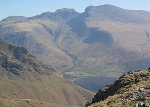
includes the country's highest mountains, in the Lake District
of Cumbria
. This was one of the first national park
s to be established in the United Kingdom
, in 1951. The highest peak is Scafell Pike
, 978 m, and at least three other summits exceed 3,000 ft (914.4 m). The mountains are chiefly Ordovician
slate
s and volcanic rock
s, with some limestone
and outcrops of other rock types. The peaks were catalogued and described in Alfred Wainwright's
seminal Pictorial Guide to the Lakeland Fells
series of books, which listed 214 summits, which have subsequently become known as Wainwrights.
and the Tyne Valley
, the land rises to form the Cheviot Hills
, which extend into Scotland
and could probably be considered part of the Southern Uplands
. They are included in Northumberland National Park
, along with Kielder Water
and the Kielder Forest
.
 The North Pennines
(an Area of Outstanding Natural Beauty
, or AONB) lie south of Hadrian's Wall, and east of the Lake District, from which they are separated by the Eden Valley
. These are younger rocks, mostly Carboniferous
limestone
, and the mountains are characterised by shallower slopes covered with moorland
vegetation, culminating in Cross Fell
at 893 m.
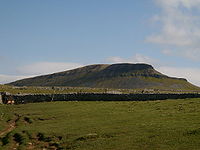
South of this, the main line of the Pennines (often called "the backbone of England") continues into the Yorkshire Dales
, a limestone
-dominated area of broad valleys and moorland. The Yorkshire Three Peaks
are some of the highest summits in the area, which became a national park in 1954.
The Yorkshire Dales end at Skipton
, and a short distance to the south is a range of moors
that rises up between the urban cores of Greater Manchester
and West Yorkshire
. The range has no continuous name - the western part as far as Blackburn is called the West Pennine Moors
, the eastern part north of the A646 (including the famous Ilkley Moor
) is called the South Pennines
, and the small area in between is known as the Forest of Rossendale. These three groups of hills are dominated by peat bogs over Millstone Grit
, and merge into the northern part of the Peak District
, known as the Dark Peak
. These areas of West Yorkshire are marketed as "Brontë country", and the local landscape provided inspiration for many of the works of the Brontë sisters, including most famously, Wuthering Heights
.
The Peak District was another of the original national parks designated in 1951, and remains the most popular in the country, largely because of its proximity to several large cities. One end of the Pennine Way
, the first long-distance footpath in the British Isles
, is in Edale
, in the Peak District, while the other end is at Kirk Yetholm
, in the Southern Uplands of Scotland.
The southern part of the Peak District (White Peak
), around Buxton
and the Hope Valley
, is another limestone area, with a number of caves, especially around Castleton. The Peak District marks the southern end of the Pennine chain, as is peters out into the English Midlands
.
AONB, in Lancashire
. Although it is near the Yorkshire Dales and the South Pennines, it does not belong to either. The isolated Pendle Hill
falls within the boundaries of the AONB.
coastal towns of Whitby
and Scarborough, and extending inland as far as Thirsk
, the North York Moors
are one of the few major upland areas in eastern England. Reaching a maximum height of 454 m at Urra Moor
, the North York Moors are home to the RAF Fylingdales
radar base. The Jurassic
limestone rocks are rich in fossil
s, which are regularly exposed by erosion of the sea cliffs.
can command extensive views. In the west, the Shropshire Hills, close to the Welsh
border, reach heights of over 500 m, including the Long Mynd
, Clee Hills
and Stiperstones
ridge. Wenlock Edge
, running through the middle of the Shropshire Hills AONB, is a long, low ridge, which extends for over 15 miles (24.1 km). Further south, the Welsh
border reaches over 700 m high, at Black Mountain
, which is thus the highest point in Herefordshire
.
Other small areas of lower hills in the Midlands include Cannock Chase
in the Staffordshire
and the Charnwood Forest
in Leicestershire
.
The Cotswolds
extend over 90 miles (144.8 km), and over six counties (Oxfordshire
, Gloucestershire
, Wiltshire
, Somerset
, Warwickshire
and Worcestershire
), but centred on Gloucestershire. They reach 330 m high at Cleeve Hill
, and were designated an AONB in 1966.
, including East Anglia
and London
, is also predominantly flat. The underlying rock is chalk
, and meaningful heights are only attained in the Chiltern Hills
(Haddington Hill
: 267 m), the North Wessex Downs (Walbury Hill
: 297 m), the North Downs
(Leith Hill
: 294 m) and the South Downs
(which includes the chalk cliffs at Beachy Head
and Seven Sisters
).
 South of Bristol
and Bath, the Mendip Hills
(Black Down
: 325 m) are the first group of hills in South West England
. The Purbeck Hills
line the South Coast, and a number of other groups of hills are also present in the area: the Quantock Hills
(Will's Neck: 384 m), Blackdown Hills
, Dorset Downs
, Salisbury Plain
and Cranborne Chase
. Glastonbury Tor
, although of only modest height (158 m), is significant for its claimed association with Arthurian legend.
The highest and largest upland areas in the south-west are, however, the moors of the South-west Peninsula. Exmoor
, in northern Somerset
, and abutting the Bristol Channel
, reaches 519 m at Dunkery Beacon
, and is famous as the setting of Lorna Doone
. Dartmoor
, in Devon
, reaches over 2,000 ft (High Willhays
: 621 m), and was the landscape for The Hound of the Baskervilles
.
Bodmin Moor
, further to the south-west, is smaller (Brown Willy
: 420 m), and is perhaps best known for the Beast of Bodmin Moor. Like Dartmoor, it is a granite
plateau
, whereas Exmoor is Old Red Sandstone
.
Mountain range
A mountain range is a single, large mass consisting of a succession of mountains or narrowly spaced mountain ridges, with or without peaks, closely related in position, direction, formation, and age; a component part of a mountain system or of a mountain chain...
which reaches over 3000 feet (914.4 m) high, to several smaller areas of lower mountains, foothills and sea cliffs. Most of the major upland areas have been designated as Areas of Outstanding Natural Beauty
Area of Outstanding Natural Beauty
An Area of Outstanding Natural Beauty is an area of countryside considered to have significant landscape value in England, Wales or Northern Ireland, that has been specially designated by the Countryside Agency on behalf of the United Kingdom government; the Countryside Council for Wales on...
(AONB) or National Parks
National parks of England and Wales
The national parks of England and Wales are areas of relatively undeveloped and scenic landscape that are designated under the National Parks and Access to the Countryside Act 1949...
. The highest and most extensive areas are in the north and west (including south-west), while the south-east and east of the country tend to be low-lying.
Lake District
Northern England
Northern England, also known as the North of England, the North or the North Country, is a cultural region of England. It is not an official government region, but rather an informal amalgamation of counties. The southern extent of the region is roughly the River Trent, while the North is bordered...
includes the country's highest mountains, in the Lake District
Lake District
The Lake District, also commonly known as The Lakes or Lakeland, is a mountainous region in North West England. A popular holiday destination, it is famous not only for its lakes and its mountains but also for its associations with the early 19th century poetry and writings of William Wordsworth...
of Cumbria
Cumbria
Cumbria , is a non-metropolitan county in North West England. The county and Cumbria County Council, its local authority, came into existence in 1974 after the passage of the Local Government Act 1972. Cumbria's largest settlement and county town is Carlisle. It consists of six districts, and in...
. This was one of the first national park
National park
A national park is a reserve of natural, semi-natural, or developed land that a sovereign state declares or owns. Although individual nations designate their own national parks differently A national park is a reserve of natural, semi-natural, or developed land that a sovereign state declares or...
s to be established in the United Kingdom
United Kingdom
The United Kingdom of Great Britain and Northern IrelandIn the United Kingdom and Dependencies, other languages have been officially recognised as legitimate autochthonous languages under the European Charter for Regional or Minority Languages...
, in 1951. The highest peak is Scafell Pike
Scafell Pike
Scafell Pike is the highest mountain in England at . It is located in Lake District National Park sometimes confused with the neighbouring Sca Fell, to which it is connected by the col of Mickledore...
, 978 m, and at least three other summits exceed 3,000 ft (914.4 m). The mountains are chiefly Ordovician
Ordovician
The Ordovician is a geologic period and system, the second of six of the Paleozoic Era, and covers the time between 488.3±1.7 to 443.7±1.5 million years ago . It follows the Cambrian Period and is followed by the Silurian Period...
slate
Slate
Slate is a fine-grained, foliated, homogeneous metamorphic rock derived from an original shale-type sedimentary rock composed of clay or volcanic ash through low-grade regional metamorphism. The result is a foliated rock in which the foliation may not correspond to the original sedimentary layering...
s and volcanic rock
Volcanic rock
Volcanic rock is a rock formed from magma erupted from a volcano. In other words, it is an igneous rock of volcanic origin...
s, with some limestone
Limestone
Limestone is a sedimentary rock composed largely of the minerals calcite and aragonite, which are different crystal forms of calcium carbonate . Many limestones are composed from skeletal fragments of marine organisms such as coral or foraminifera....
and outcrops of other rock types. The peaks were catalogued and described in Alfred Wainwright's
Alfred Wainwright
Alfred Wainwright MBE was a British fellwalker, guidebook author and illustrator. His seven-volume Pictorial Guide to the Lakeland Fells, published between 1955 and 1966 and consisting entirely of reproductions of his manuscript, has become the standard reference work to 214 of the fells of the...
seminal Pictorial Guide to the Lakeland Fells
Pictorial Guide to the Lakeland Fells
A Pictorial Guide to the Lakeland Fells is a series of seven books by A. Wainwright, detailing the fells of the Lake District in northwest England...
series of books, which listed 214 summits, which have subsequently become known as Wainwrights.
Cheviot Hills
North of Hadrian's WallHadrian's Wall
Hadrian's Wall was a defensive fortification in Roman Britain. Begun in AD 122, during the rule of emperor Hadrian, it was the first of two fortifications built across Great Britain, the second being the Antonine Wall, lesser known of the two because its physical remains are less evident today.The...
and the Tyne Valley
River Tyne
The River Tyne is a river in North East England in Great Britain. It is formed by the confluence of two rivers: the North Tyne and the South Tyne. These two rivers converge at Warden Rock near Hexham in Northumberland at a place dubbed 'The Meeting of the Waters'.The North Tyne rises on the...
, the land rises to form the Cheviot Hills
Cheviot Hills
The Cheviot Hills is a range of rolling hills straddling the England–Scotland border between Northumberland and the Scottish Borders.There is a broad split between the northern and the southern Cheviots...
, which extend into Scotland
Scotland
Scotland is a country that is part of the United Kingdom. Occupying the northern third of the island of Great Britain, it shares a border with England to the south and is bounded by the North Sea to the east, the Atlantic Ocean to the north and west, and the North Channel and Irish Sea to the...
and could probably be considered part of the Southern Uplands
Southern Uplands
The Southern Uplands are the southernmost and least populous of mainland Scotland's three major geographic areas . The term is used both to describe the geographical region and to collectively denote the various ranges of hills within this region...
. They are included in Northumberland National Park
Northumberland National Park
Northumberland National Park is the northernmost national park in England. It covers an area of more than 1030 km² between the Scottish Border in the north to just south of Hadrian's Wall. It is one of the least populated and least visited of the National Parks...
, along with Kielder Water
Kielder Water
Kielder Water is a large artificial reservoir in Northumberland in North East England. It is the largest artificial lake in the United Kingdom by capacity and it is surrounded by Kielder Forest, the largest human-made woodland in Europe. It was planned in the late 1960s to satisfy an expected rise...
and the Kielder Forest
Kielder Forest
Kielder Forest is a large forestry plantation in Northumberland, England, surrounding the reservoir Kielder Water. It is the largest man-made woodland in Europe...
.
Pennines
North Pennines
The North Pennines is the northernmost section of the Pennine range of hills which runs north-south through northern England. It lies between Carlisle to the west and Darlington to the east...
(an Area of Outstanding Natural Beauty
Area of Outstanding Natural Beauty
An Area of Outstanding Natural Beauty is an area of countryside considered to have significant landscape value in England, Wales or Northern Ireland, that has been specially designated by the Countryside Agency on behalf of the United Kingdom government; the Countryside Council for Wales on...
, or AONB) lie south of Hadrian's Wall, and east of the Lake District, from which they are separated by the Eden Valley
River Eden, Cumbria
The River Eden is a river that flows through Cumbria, England on its way to the Solway Firth.-Course of river:The Eden rises in Black Fell Moss, Mallerstang, on the high ground between High Seat, Yorkshire Dales and Hugh Seat. Here it forms the boundary between the counties of Cumbria and North...
. These are younger rocks, mostly Carboniferous
Carboniferous
The Carboniferous is a geologic period and system that extends from the end of the Devonian Period, about 359.2 ± 2.5 Mya , to the beginning of the Permian Period, about 299.0 ± 0.8 Mya . The name is derived from the Latin word for coal, carbo. Carboniferous means "coal-bearing"...
limestone
Limestone
Limestone is a sedimentary rock composed largely of the minerals calcite and aragonite, which are different crystal forms of calcium carbonate . Many limestones are composed from skeletal fragments of marine organisms such as coral or foraminifera....
, and the mountains are characterised by shallower slopes covered with moorland
Moorland
Moorland or moor is a type of habitat, in the temperate grasslands, savannas, and shrublands biome, found in upland areas, characterised by low-growing vegetation on acidic soils and heavy fog...
vegetation, culminating in Cross Fell
Cross Fell
Cross Fell is the highest point in the Pennine Hills of northern England and the highest point in England outside of the Lake District.The summit, at , is a stony plateau, part of a long ridge running North West to South East, which also incorporates Little Dun Fell at and Great Dun Fell at...
at 893 m.
South of this, the main line of the Pennines (often called "the backbone of England") continues into the Yorkshire Dales
Yorkshire Dales
The Yorkshire Dales is the name given to an upland area in Northern England.The area lies within the historic county boundaries of Yorkshire, though it spans the ceremonial counties of North Yorkshire, West Yorkshire and Cumbria...
, a limestone
Limestone
Limestone is a sedimentary rock composed largely of the minerals calcite and aragonite, which are different crystal forms of calcium carbonate . Many limestones are composed from skeletal fragments of marine organisms such as coral or foraminifera....
-dominated area of broad valleys and moorland. The Yorkshire Three Peaks
Yorkshire three peaks
The mountains of Whernside , Ingleborough and Pen-y-ghent are collectively known as the Three Peaks. The peaks, which form part of the...
are some of the highest summits in the area, which became a national park in 1954.
The Yorkshire Dales end at Skipton
Skipton
Skipton is a market town and civil parish within the Craven district of North Yorkshire, England. It is located along the course of both the Leeds and Liverpool Canal and the River Aire, on the south side of the Yorkshire Dales, northwest of Bradford and west of York...
, and a short distance to the south is a range of moors
Moors
The description Moors has referred to several historic and modern populations of the Maghreb region who are predominately of Berber and Arab descent. They came to conquer and rule the Iberian Peninsula for nearly 800 years. At that time they were Muslim, although earlier the people had followed...
that rises up between the urban cores of Greater Manchester
Greater Manchester
Greater Manchester is a metropolitan county in North West England, with a population of 2.6 million. It encompasses one of the largest metropolitan areas in the United Kingdom and comprises ten metropolitan boroughs: Bolton, Bury, Oldham, Rochdale, Stockport, Tameside, Trafford, Wigan, and the...
and West Yorkshire
West Yorkshire
West Yorkshire is a metropolitan county within the Yorkshire and the Humber region of England with a population of 2.2 million. West Yorkshire came into existence as a metropolitan county in 1974 after the passage of the Local Government Act 1972....
. The range has no continuous name - the western part as far as Blackburn is called the West Pennine Moors
West Pennine Moors
The West Pennine Moors cover an area of approximately of moorland and reservoirs in Lancashire and Greater Manchester, England.The West Pennine Moors are separated from the main Pennine range by the Irwell Valley. The moorland includes Withnell, Anglezarke and Rivington Moors in the extreme west,...
, the eastern part north of the A646 (including the famous Ilkley Moor
Ilkley Moor
Ilkley Moor is part of Rombalds Moor, the moorland between Ilkley and Keighley in West Yorkshire, England, United Kingdom. The peat bogs rise to 402 m above sea level...
) is called the South Pennines
South Pennines
South Pennines is a region of moorland and hill country in northern England lying towards the southern end of the Pennines. It is bounded to the west by the Forest of Rossendale and the Yorkshire Dales to the north...
, and the small area in between is known as the Forest of Rossendale. These three groups of hills are dominated by peat bogs over Millstone Grit
Millstone Grit
Millstone Grit is the name given to any of a number of coarse-grained sandstones of Carboniferous age which occur in the Northern England. The name derives from its use in earlier times as a source of millstones for use principally in watermills...
, and merge into the northern part of the Peak District
Peak District
The Peak District is an upland area in central and northern England, lying mainly in northern Derbyshire, but also covering parts of Cheshire, Greater Manchester, Staffordshire, and South and West Yorkshire....
, known as the Dark Peak
Dark Peak
The Dark Peak is the higher, wilder northern part of the Peak District in England.It gets its name because , the underlying limestone is covered by a cap of Millstone Grit which means that in winter the soil is almost always saturated with water...
. These areas of West Yorkshire are marketed as "Brontë country", and the local landscape provided inspiration for many of the works of the Brontë sisters, including most famously, Wuthering Heights
Wuthering Heights
Wuthering Heights is a novel by Emily Brontë published in 1847. It was her only novel and written between December 1845 and July 1846. It remained unpublished until July 1847 and was not printed until December after the success of her sister Charlotte Brontë's novel Jane Eyre...
.
The Peak District was another of the original national parks designated in 1951, and remains the most popular in the country, largely because of its proximity to several large cities. One end of the Pennine Way
Pennine Way
The Pennine Way is a National Trail in England. The trail runs from Edale, in the northern Derbyshire Peak District, north through the Yorkshire Dales and the Northumberland National Park and ends at Kirk Yetholm, just inside the Scottish border. The path runs along the Pennine hills, sometimes...
, the first long-distance footpath in the British Isles
British Isles
The British Isles are a group of islands off the northwest coast of continental Europe that include the islands of Great Britain and Ireland and over six thousand smaller isles. There are two sovereign states located on the islands: the United Kingdom of Great Britain and Northern Ireland and...
, is in Edale
Edale
Edale is a small Derbyshire village and Civil parish in the Peak District, in the Midlands of England. The Parish of Edale,area ,is in the Borough of High Peak....
, in the Peak District, while the other end is at Kirk Yetholm
Kirk Yetholm
Kirk Yetholm is a village in the Scottish Borders region of Scotland, south east of Kelso and less than west of the border. The first mention is of its church in the 13th century. Its sister town is Town Yetholm which lies half a mile across the Bowmont Water...
, in the Southern Uplands of Scotland.
The southern part of the Peak District (White Peak
White Peak
The White Peak is the lower, southern part of the Peak District in England. In contrast to the Dark Peak, the underlying limestone is not capped by impervious millstone grit, so caves and dry river valleys are common features of the area...
), around Buxton
Buxton
Buxton is a spa town in Derbyshire, England. It has the highest elevation of any market town in England. Located close to the county boundary with Cheshire to the west and Staffordshire to the south, Buxton is described as "the gateway to the Peak District National Park"...
and the Hope Valley
Hope Valley, Derbyshire
The Hope Valley is a rural area centred on the village of Hope, Derbyshire in the Peak District in the northern Midlands of England.The name also applies to the Post Town which includes the surrounding villages.-The Valley:...
, is another limestone area, with a number of caves, especially around Castleton. The Peak District marks the southern end of the Pennine chain, as is peters out into the English Midlands
English Midlands
The Midlands, or the English Midlands, is the traditional name for the area comprising central England that broadly corresponds to the early medieval Kingdom of Mercia. It borders Southern England, Northern England, East Anglia and Wales. Its largest city is Birmingham, and it was an important...
.
Forest of Bowland
Away from the main chain of the Pennines, two other noteworthy upland areas exist. One of these is the Forest of BowlandForest of Bowland
The Forest of Bowland, also known as the Bowland Fells, is an area of barren gritstone fells, deep valleys and peat moorland, mostly in north-east Lancashire, England. A small part lies in North Yorkshire, and much of the area was historically part of the West Riding of Yorkshire...
AONB, in Lancashire
Lancashire
Lancashire is a non-metropolitan county of historic origin in the North West of England. It takes its name from the city of Lancaster, and is sometimes known as the County of Lancaster. Although Lancaster is still considered to be the county town, Lancashire County Council is based in Preston...
. Although it is near the Yorkshire Dales and the South Pennines, it does not belong to either. The isolated Pendle Hill
Pendle Hill
Pendle Hill is located in the north-east of Lancashire, England, near the towns of Burnley, Nelson, Colne, Clitheroe and Padiham, an area known as Pendleside. Its summit is above mean sea level. It gives its name to the Borough of Pendle. It is an isolated hill, separated from the Pennines to the...
falls within the boundaries of the AONB.
North York Moors
Near the North YorkshireNorth Yorkshire
North Yorkshire is a non-metropolitan or shire county located in the Yorkshire and the Humber region of England, and a ceremonial county primarily in that region but partly in North East England. Created in 1974 by the Local Government Act 1972 it covers an area of , making it the largest...
coastal towns of Whitby
Whitby
Whitby is a seaside town, port and civil parish in the Scarborough borough of North Yorkshire, England. Situated on the east coast of Yorkshire at the mouth of the River Esk, Whitby has a combined maritime, mineral and tourist heritage, and is home to the ruins of Whitby Abbey where Caedmon, the...
and Scarborough, and extending inland as far as Thirsk
Thirsk
Thirsk is a small market town and civil parish in the Hambleton district of North Yorkshire, England. The local travel links are located a mile from the town centre to Thirsk railway station and to Durham Tees Valley Airport...
, the North York Moors
North York Moors
The North York Moors is a national park in North Yorkshire, England. The moors are one of the largest expanses of heather moorland in the United Kingdom. It covers an area of , and it has a population of about 25,000...
are one of the few major upland areas in eastern England. Reaching a maximum height of 454 m at Urra Moor
Urra Moor
Urra Moor is the highest moor in the North York Moors at 454 metres above sea level, in the national park in North Yorkshire, England. The name applies to the moor as a whole; the summit itself is known as Round Hill....
, the North York Moors are home to the RAF Fylingdales
RAF Fylingdales
RAF Fylingdales is a Royal Air Force station on Snod Hill in the North York Moors, England. Its motto is "Vigilamus" . It is a radar base and part of the United States-controlled Ballistic Missile Early Warning System...
radar base. The Jurassic
Jurassic
The Jurassic is a geologic period and system that extends from about Mya to Mya, that is, from the end of the Triassic to the beginning of the Cretaceous. The Jurassic constitutes the middle period of the Mesozoic era, also known as the age of reptiles. The start of the period is marked by...
limestone rocks are rich in fossil
Fossil
Fossils are the preserved remains or traces of animals , plants, and other organisms from the remote past...
s, which are regularly exposed by erosion of the sea cliffs.
Midlands
The English Midlands are predominantly flat in character, although isolated hills such as Turners HillTurners Hill, West Midlands
Turners Hill or Turner's Hill is the highest hill in the West Midlands, England, at 271m above sea level. The hill is situated on the border of Dudley and Rowley Regis, in the Metropolitan Borough of Sandwell , in a rural part of the predominantly industrial Black Country.The hill can be seen from...
can command extensive views. In the west, the Shropshire Hills, close to the Welsh
Wales
Wales is a country that is part of the United Kingdom and the island of Great Britain, bordered by England to its east and the Atlantic Ocean and Irish Sea to its west. It has a population of three million, and a total area of 20,779 km²...
border, reach heights of over 500 m, including the Long Mynd
Long Mynd
The Long Mynd in Shropshire, England, is a part of the Shropshire Hills Area of Outstanding Natural Beauty. It is south of the county town Shrewsbury, and has an area of over 22 square kilometres , most of which takes the form of a heathland plateau. Most of the land on the Long Mynd is owned by...
, Clee Hills
Clee Hills
The Clee Hills are a range of hills in Shropshire, England near Ludlow, consisting of Brown Clee Hill , the highest peak in Shropshire, and Titterstone Clee Hill...
and Stiperstones
Stiperstones
The Stiperstones is a very distinctive hill in the county of Shropshire, England. It is a quartzite ridge formed some 480 Million years ago. During the last Ice Age the summit stood out above the glaciers and was subject to constant freezing and thawing which shattered the quartzite into a mass of...
ridge. Wenlock Edge
Wenlock Edge
Wenlock Edge is a limestone escarpment near Much Wenlock, Shropshire, England. It is long and runs from South West to North East between Craven Arms and Much Wenlock. It is roughly 330 metres high...
, running through the middle of the Shropshire Hills AONB, is a long, low ridge, which extends for over 15 miles (24.1 km). Further south, the Welsh
Wales
Wales is a country that is part of the United Kingdom and the island of Great Britain, bordered by England to its east and the Atlantic Ocean and Irish Sea to its west. It has a population of three million, and a total area of 20,779 km²...
border reaches over 700 m high, at Black Mountain
Black Mountain (hill)
Twyn Llech also known as Black Mountain is a mountain in the Black Mountains . It is the only Marilyn to fall exactly on the Welsh-English border, straddling Powys and Herefordshire...
, which is thus the highest point in Herefordshire
Herefordshire
Herefordshire is a historic and ceremonial county in the West Midlands region of England. For Eurostat purposes it is a NUTS 3 region and is one of three counties that comprise the "Herefordshire, Worcestershire and Gloucestershire" NUTS 2 region. It also forms a unitary district known as the...
.
Other small areas of lower hills in the Midlands include Cannock Chase
Cannock Chase
Cannock Chase is a mixed area of countryside in the county of Staffordshire, England. The area has been designated as the Cannock Chase Area of Outstanding Natural Beauty. The Chase gives its name to the Cannock Chase local government district....
in the Staffordshire
Staffordshire
Staffordshire is a landlocked county in the West Midlands region of England. For Eurostat purposes, the county is a NUTS 3 region and is one of four counties or unitary districts that comprise the "Shropshire and Staffordshire" NUTS 2 region. Part of the National Forest lies within its borders...
and the Charnwood Forest
Charnwood Forest
Charnwood Forest is an upland tract in north-western Leicestershire, England, bounded by Leicester, Loughborough, and Coalville. The area is undulating, rocky and picturesque, with barren areas. It also has some extensive tracts of woodland; its elevation is generally 600 ft and upwards, the area...
in Leicestershire
Leicestershire
Leicestershire is a landlocked county in the English Midlands. It takes its name from the heavily populated City of Leicester, traditionally its administrative centre, although the City of Leicester unitary authority is today administered separately from the rest of Leicestershire...
.
The Cotswolds
Cotswolds
The Cotswolds are a range of hills in west-central England, sometimes called the Heart of England, an area across and long. The area has been designated as the Cotswold Area of Outstanding Natural Beauty...
extend over 90 miles (144.8 km), and over six counties (Oxfordshire
Oxfordshire
Oxfordshire is a county in the South East region of England, bordering on Warwickshire and Northamptonshire , Buckinghamshire , Berkshire , Wiltshire and Gloucestershire ....
, Gloucestershire
Gloucestershire
Gloucestershire is a county in South West England. The county comprises part of the Cotswold Hills, part of the flat fertile valley of the River Severn, and the entire Forest of Dean....
, Wiltshire
Wiltshire
Wiltshire is a ceremonial county in South West England. It is landlocked and borders the counties of Dorset, Somerset, Hampshire, Gloucestershire, Oxfordshire and Berkshire. It contains the unitary authority of Swindon and covers...
, Somerset
Somerset
The ceremonial and non-metropolitan county of Somerset in South West England borders Bristol and Gloucestershire to the north, Wiltshire to the east, Dorset to the south-east, and Devon to the south-west. It is partly bounded to the north and west by the Bristol Channel and the estuary of the...
, Warwickshire
Warwickshire
Warwickshire is a landlocked non-metropolitan county in the West Midlands region of England. The county town is Warwick, although the largest town is Nuneaton. The county is famous for being the birthplace of William Shakespeare...
and Worcestershire
Worcestershire
Worcestershire is a non-metropolitan county, established in antiquity, located in the West Midlands region of England. For Eurostat purposes it is a NUTS 3 region and is one of three counties that comprise the "Herefordshire, Worcestershire and Warwickshire" NUTS 2 region...
), but centred on Gloucestershire. They reach 330 m high at Cleeve Hill
Cleeve Hill
Cleeve Hill is the highest point both in the Cotswolds hill range and in the county of Gloucestershire, at . It commands a clear view to the west, over Cheltenham and the racecourse, over the River Severn and into Wales; and to the north over Winchcombe. It is a conspicuous outcrop on the edge of...
, and were designated an AONB in 1966.
South East England
South East EnglandSouth East England
South East England is one of the nine official regions of England, designated in 1994 and adopted for statistical purposes in 1999. It consists of Berkshire, Buckinghamshire, East Sussex, Hampshire, Isle of Wight, Kent, Oxfordshire, Surrey and West Sussex...
, including East Anglia
East Anglia
East Anglia is a traditional name for a region of eastern England, named after an ancient Anglo-Saxon kingdom, the Kingdom of the East Angles. The Angles took their name from their homeland Angeln, in northern Germany. East Anglia initially consisted of Norfolk and Suffolk, but upon the marriage of...
and London
London
London is the capital city of :England and the :United Kingdom, the largest metropolitan area in the United Kingdom, and the largest urban zone in the European Union by most measures. Located on the River Thames, London has been a major settlement for two millennia, its history going back to its...
, is also predominantly flat. The underlying rock is chalk
Chalk
Chalk is a soft, white, porous sedimentary rock, a form of limestone composed of the mineral calcite. Calcite is calcium carbonate or CaCO3. It forms under reasonably deep marine conditions from the gradual accumulation of minute calcite plates shed from micro-organisms called coccolithophores....
, and meaningful heights are only attained in the Chiltern Hills
Chiltern Hills
The Chiltern Hills form a chalk escarpment in South East England. They are known locally as "the Chilterns". A large portion of the hills was designated officially as an Area of Outstanding Natural Beauty in 1965.-Location:...
(Haddington Hill
Haddington Hill
Haddington Hill is a hill in The Chilterns, and the highest point in the English county of Buckinghamshire. On the north-eastern flank is Coombe Hill, not to be confused with another Coombe Hill 4 kilometres to the south-west....
: 267 m), the North Wessex Downs (Walbury Hill
Walbury Hill
Walbury Hill is the highest point in the traditional county of Berkshire in the UK at above sea level. It is also the highest point in the South East of England, West Berkshire being a constituent part of the South East of England...
: 297 m), the North Downs
North Downs
The North Downs are a ridge of chalk hills in south east England that stretch from Farnham in Surrey to the White Cliffs of Dover in Kent. The North Downs lie within two Areas of Outstanding Natural Beauty , the Surrey Hills and the Kent Downs...
(Leith Hill
Leith Hill
Leith Hill to the south west of Dorking, Surrey, England, reaches above sea level, the highest point on the Greensand Ridge, and is the second highest point in south-east England, after Walbury Hill near Hungerford, West Berkshire, high....
: 294 m) and the South Downs
South Downs
The South Downs is a range of chalk hills that extends for about across the south-eastern coastal counties of England from the Itchen Valley of Hampshire in the west to Beachy Head, near Eastbourne, East Sussex, in the east. It is bounded on its northern side by a steep escarpment, from whose...
(which includes the chalk cliffs at Beachy Head
Beachy Head
Beachy Head is a chalk headland on the south coast of England, close to the town of Eastbourne in the county of East Sussex, immediately east of the Seven Sisters. The cliff there is the highest chalk sea cliff in Britain, rising to 162 m above sea level. The peak allows views of the south...
and Seven Sisters
Seven Sisters, Sussex
The Seven Sisters are a series of chalk cliffs by the English Channel. They form part of the South Downs in East Sussex, between the towns of Seaford and Eastbourne in southern England. They are within the Seven Sisters Country Park...
).
South West England
Bristol
Bristol is a city, unitary authority area and ceremonial county in South West England, with an estimated population of 433,100 for the unitary authority in 2009, and a surrounding Larger Urban Zone with an estimated 1,070,000 residents in 2007...
and Bath, the Mendip Hills
Mendip Hills
The Mendip Hills is a range of limestone hills to the south of Bristol and Bath in Somerset, England. Running east to west between Weston-super-Mare and Frome, the hills overlook the Somerset Levels to the south and the Avon Valley to the north...
(Black Down
Black Down, Somerset
Black Down is the highest hill in the Mendip Hills, Somerset, in south-western England. Black Down lies just a few miles eastward of the Bristol Channel at Weston-super-Mare, and provides a view over the Chew Valley...
: 325 m) are the first group of hills in South West England
South West England
South West England is one of the regions of England defined by the Government of the United Kingdom for statistical and other purposes. It is the largest such region in area, covering and comprising Bristol, Gloucestershire, Somerset, Dorset, Wiltshire, Devon, Cornwall and the Isles of Scilly. ...
. The Purbeck Hills
Purbeck Hills
The Purbeck Hills and South Dorset Downs are a ridge of chalk downs in Dorset, England. The hills extend from the Dorset Downs west of Dorchester, where the River Frome begins to form a valley dividing them from the larger area of downland to the north. The ridge then runs east through the Isle...
line the South Coast, and a number of other groups of hills are also present in the area: the Quantock Hills
Quantock Hills
The Quantock Hills is a range of hills west of Bridgwater in Somerset, England. The Quantock Hills were England’s first Area of Outstanding Natural Beauty being designated in 1956 and consists of large amounts of heathland, oak woodlands, ancient parklands and agricultural land.The hills run from...
(Will's Neck: 384 m), Blackdown Hills
Blackdown Hills
The Blackdown Hills are a range of hills along the Somerset-Devon border in south-western England, which were designated an Area of Outstanding Natural Beauty in 1991....
, Dorset Downs
Dorset Downs
The Dorset Downs are an area of Chalk downland in the centre of the county Dorset in south west England. The downs are the most western part of a larger Chalk Formation which also includes Cranborne Chase, Salisbury Plain, Hampshire Downs, Chiltern Hills, North Downs and South Downs.The Dorset...
, Salisbury Plain
Salisbury Plain
Salisbury Plain is a chalk plateau in central southern England covering . It is part of the Southern England Chalk Formation and largely lies within the county of Wiltshire, with a little in Hampshire. The plain is famous for its rich archaeology, including Stonehenge, one of England's best known...
and Cranborne Chase
Cranborne Chase
Cranborne Chase is a Chalk plateau in central southern England, straddling the counties Dorset, Hampshire and Wiltshire. The plateau is part of the English Chalk Formation and is adjacent to Salisbury Plain and the West Wiltshire Downs in the north, the Dorset Downs to the south west and the...
. Glastonbury Tor
Glastonbury Tor
Glastonbury Tor is a hill at Glastonbury, Somerset, England, which features the roofless St. Michael's Tower. The site is managed by the National Trust. It has been designated as a Scheduled Ancient Monument ....
, although of only modest height (158 m), is significant for its claimed association with Arthurian legend.
The highest and largest upland areas in the south-west are, however, the moors of the South-west Peninsula. Exmoor
Exmoor
Exmoor is an area of hilly open moorland in west Somerset and north Devon in South West England, named after the main river that flows out of the district, the River Exe. The moor has given its name to a National Park, which includes the Brendon Hills, the East Lyn Valley, the Vale of Porlock and ...
, in northern Somerset
Somerset
The ceremonial and non-metropolitan county of Somerset in South West England borders Bristol and Gloucestershire to the north, Wiltshire to the east, Dorset to the south-east, and Devon to the south-west. It is partly bounded to the north and west by the Bristol Channel and the estuary of the...
, and abutting the Bristol Channel
Bristol Channel
The Bristol Channel is a major inlet in the island of Great Britain, separating South Wales from Devon and Somerset in South West England. It extends from the lower estuary of the River Severn to the North Atlantic Ocean...
, reaches 519 m at Dunkery Beacon
Dunkery Beacon
Dunkery Beacon is the summit of Dunkery Hill, and the highest point on Exmoor and in Somerset, England. It is also the highest point in southern England outside Dartmoor....
, and is famous as the setting of Lorna Doone
Lorna Doone
Lorna Doone: A Romance of Exmoor is a novel by Richard Doddridge Blackmore. It is a romance based on a group of historical characters and set in the late 17th century in Devon and Somerset, particularly around the East Lyn Valley area of Exmoor....
. Dartmoor
Dartmoor
Dartmoor is an area of moorland in south Devon, England. Protected by National Park status, it covers .The granite upland dates from the Carboniferous period of geological history. The moorland is capped with many exposed granite hilltops known as tors, providing habitats for Dartmoor wildlife. The...
, in Devon
Devon
Devon is a large county in southwestern England. The county is sometimes referred to as Devonshire, although the term is rarely used inside the county itself as the county has never been officially "shired", it often indicates a traditional or historical context.The county shares borders with...
, reaches over 2,000 ft (High Willhays
High Willhays
High Willhays or, according to some authors, High Willes is the highest point on Dartmoor, Devon, at 621 metres above sea level, and the highest point in Great Britain south of the Brecon Beacons.-Toponymy:...
: 621 m), and was the landscape for The Hound of the Baskervilles
The Hound of the Baskervilles
The Hound of the Baskervilles is the third of four crime novels by Sir Arthur Conan Doyle featuring the detective Sherlock Holmes. Originally serialised in The Strand Magazine from August 1901 to April 1902, it is set largely on Dartmoor in Devon in England's West Country and tells the story of an...
.
Bodmin Moor
Bodmin Moor
Bodmin Moor is a granite moorland in northeastern Cornwall, England, United Kingdom. It is in size, and originally dates from the Carboniferous period of geological history....
, further to the south-west, is smaller (Brown Willy
Brown Willy
Brown Willy is a hill in Cornwall, United Kingdom. The summit is the highest point of Bodmin Moor and of Cornwall as a whole....
: 420 m), and is perhaps best known for the Beast of Bodmin Moor. Like Dartmoor, it is a granite
Granite
Granite is a common and widely occurring type of intrusive, felsic, igneous rock. Granite usually has a medium- to coarse-grained texture. Occasionally some individual crystals are larger than the groundmass, in which case the texture is known as porphyritic. A granitic rock with a porphyritic...
plateau
Plateau
In geology and earth science, a plateau , also called a high plain or tableland, is an area of highland, usually consisting of relatively flat terrain. A highly eroded plateau is called a dissected plateau...
, whereas Exmoor is Old Red Sandstone
Old Red Sandstone
The Old Red Sandstone is a British rock formation of considerable importance to early paleontology. For convenience the short version of the term, 'ORS' is often used in literature on the subject.-Sedimentology:...
.
See also
- Hill lists in the British IslesHill lists in the British IslesThe mountains and hills of Great Britain, and to a lesser extent Ireland, are the subject of a considerable number of lists that categorise them by height, topographic prominence, or other criteria. They are commonly used as a basis for peak bagging, whereby hillwalkers attempt to reach all the...
- List of English counties by highest point
- List of Hewitts and Nuttalls in England