
Cleeve Hill
Encyclopedia
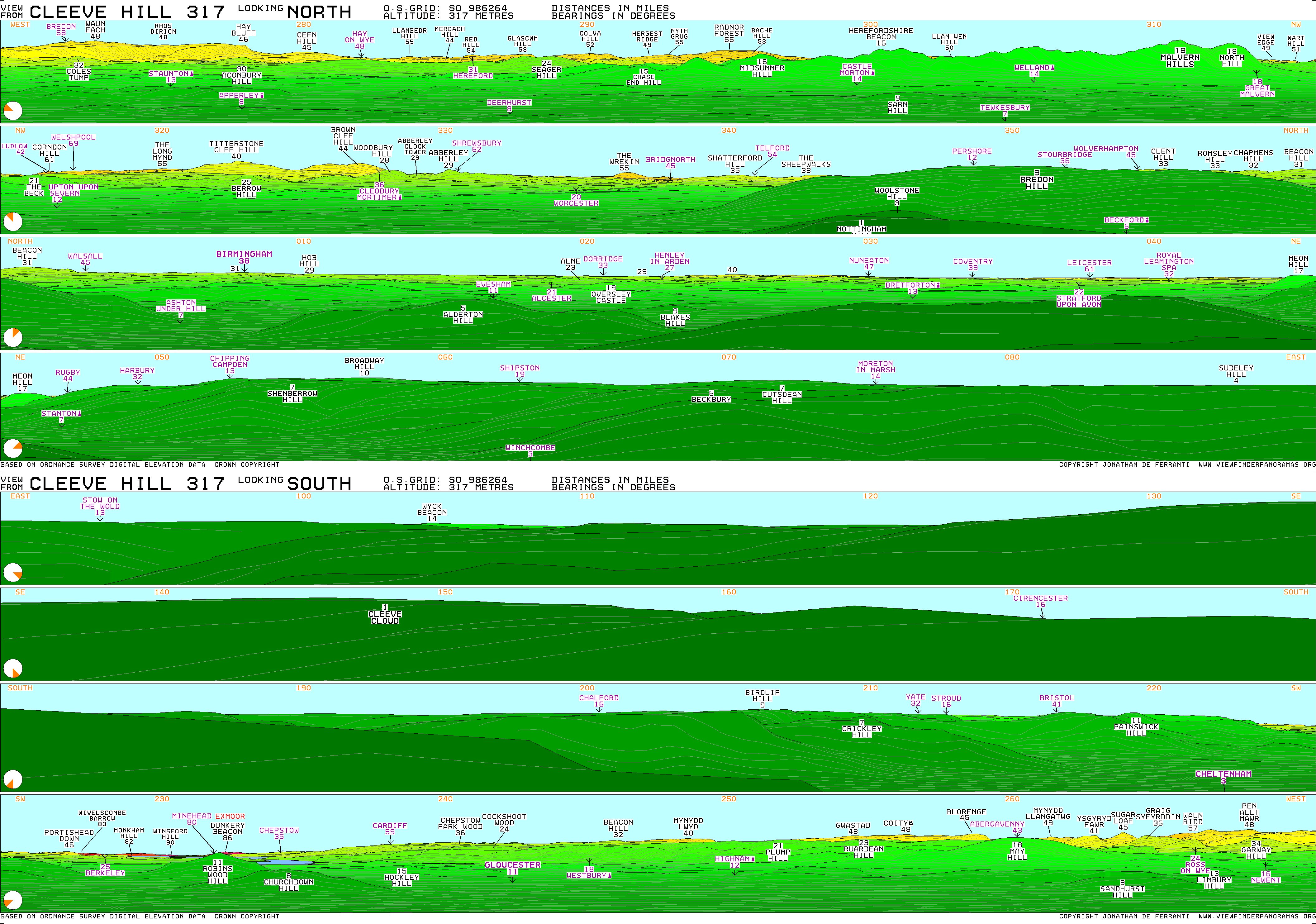
Cleeve Hill is the highest point both in the Cotswolds
hill range and in the county
of Gloucestershire
, at 1083 feet (330.1 m). It commands a clear view to the west, over Cheltenham
and the racecourse
, over the River Severn
and into Wales
; and to the north over Winchcombe
. It is a conspicuous outcrop
on the edge of the limestone
escarpment
, (sometimes called the "Cotswold Edge"). It is crossed by the Cotswold Way
footpath.
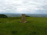
The summit, at 1083 ft (330.1 m), is a nondescript point marked by a trig point
on the relatively flat common south of the Hill. Because of this, it does not offer particularly wide-ranging views. To the North by north-west, another summit at 1033 ft (314.9 m) high boasts a toposcope
and a trig-point, offering far wider views. On an exceptionally clear day (for example a sunny day following a day of rain in spring or early summer), the view extends an impressive 90 miles (144.8 km) to Winsford
Hill
on Exmoor
, Somerset
.
Taking the road up from Aggs Hill you can expect to see three tall radio masts situated 430 yards from the highest point (1,083 ft) above sea level
.
Close to the summit is the Neolithic
long barrow
, Belas Knap
. On its western scarp
is an Iron Age
hill fort
.
The Hill bears one of the few rock faces in the area, Castle Rock, which is sound enough for rock-climbing
. The routes are short, difficult for their grade and highly polished.
The Hill has been home to a golf course
since 1891. The course was the location of the 2010 Wells Cup that took place in June 2010.
.
To the north and to reach the more favourable view point, a minor road leads off the B4632 to the golf course where there is free parking in a disused quarry. From this point, the viewpoint is roughly a half-mile ascent on foot.
There are numerous other ways to reach the hill, and there is a well-maintained network of paths and tracks crossing it in many directions. Ordnance Survey
maps show all routes, paths and rights of way as well as the best viewpoints.
Cotswolds
The Cotswolds are a range of hills in west-central England, sometimes called the Heart of England, an area across and long. The area has been designated as the Cotswold Area of Outstanding Natural Beauty...
hill range and in the county
County
A county is a jurisdiction of local government in certain modern nations. Historically in mainland Europe, the original French term, comté, and its equivalents in other languages denoted a jurisdiction under the sovereignty of a count A county is a jurisdiction of local government in certain...
of Gloucestershire
Gloucestershire
Gloucestershire is a county in South West England. The county comprises part of the Cotswold Hills, part of the flat fertile valley of the River Severn, and the entire Forest of Dean....
, at 1083 feet (330.1 m). It commands a clear view to the west, over Cheltenham
Cheltenham
Cheltenham , also known as Cheltenham Spa, is a large spa town and borough in Gloucestershire, on the edge of the Cotswolds in the South-West region of England. It is the home of the flagship race of British steeplechase horse racing, the Gold Cup, the main event of the Cheltenham Festival held...
and the racecourse
Cheltenham Racecourse
Cheltenham Racecourse is a racecourse for horse racing events, located at Prestbury Park, in the suburban village of Prestbury on the outskirts of the English town of Cheltenham, Gloucestershire...
, over the River Severn
River Severn
The River Severn is the longest river in Great Britain, at about , but the second longest on the British Isles, behind the River Shannon. It rises at an altitude of on Plynlimon, Ceredigion near Llanidloes, Powys, in the Cambrian Mountains of mid Wales...
and into Wales
Wales
Wales is a country that is part of the United Kingdom and the island of Great Britain, bordered by England to its east and the Atlantic Ocean and Irish Sea to its west. It has a population of three million, and a total area of 20,779 km²...
; and to the north over Winchcombe
Winchcombe
Winchcombe is a Cotswold town in the local authority district of Tewkesbury, in Gloucestershire, England. Its population according to the 2001 census was 4,379.-Early history:...
. It is a conspicuous outcrop
Outcrop
An outcrop is a visible exposure of bedrock or ancient superficial deposits on the surface of the Earth. -Features:Outcrops do not cover the majority of the Earth's land surface because in most places the bedrock or superficial deposits are covered by a mantle of soil and vegetation and cannot be...
on the edge of the limestone
Oolite
Oolite is a sedimentary rock formed from ooids, spherical grains composed of concentric layers. The name derives from the Hellenic word òoion for egg. Strictly, oolites consist of ooids of diameter 0.25–2 mm; rocks composed of ooids larger than 2 mm are called pisolites...
escarpment
Escarpment
An escarpment is a steep slope or long cliff that occurs from erosion or faulting and separates two relatively level areas of differing elevations.-Description and variants:...
, (sometimes called the "Cotswold Edge"). It is crossed by the Cotswold Way
Cotswold Way
The Cotswold Way is a long-distance footpath, running along the Cotswold Edge escarpment of the Cotswold Hills in England. It was officially inaugurated as a National Trail on 24 May 2007 and several new rights of way have been created.-History:...
footpath.
The summit, at 1083 ft (330.1 m), is a nondescript point marked by a trig point
Trig point
A triangulation station, also known as a triangulation pillar, trigonometrical station, trigonometrical point, trig station, trig beacon or trig point, and sometimes informally as a trig, is a fixed surveying station, used in geodetic surveying and other surveying projects in its vicinity...
on the relatively flat common south of the Hill. Because of this, it does not offer particularly wide-ranging views. To the North by north-west, another summit at 1033 ft (314.9 m) high boasts a toposcope
Toposcope
A toposcope or topograph is a marker erected on hills, mountains or high places which indicates the direction, and usually the distance, to notable landscape features which can be seen from that point...
and a trig-point, offering far wider views. On an exceptionally clear day (for example a sunny day following a day of rain in spring or early summer), the view extends an impressive 90 miles (144.8 km) to Winsford
Winsford
Winsford is a town and civil parish within the unitary authority of Cheshire West and Chester and the ceremonial county of Cheshire, England. It lies on the River Weaver south of Northwich and west of Middlewich, and grew around the salt mining industry after the river was canalised in the...
Hill
Hill
A hill is a landform that extends above the surrounding terrain. Hills often have a distinct summit, although in areas with scarp/dip topography a hill may refer to a particular section of flat terrain without a massive summit A hill is a landform that extends above the surrounding terrain. Hills...
on Exmoor
Exmoor
Exmoor is an area of hilly open moorland in west Somerset and north Devon in South West England, named after the main river that flows out of the district, the River Exe. The moor has given its name to a National Park, which includes the Brendon Hills, the East Lyn Valley, the Vale of Porlock and ...
, Somerset
Somerset
The ceremonial and non-metropolitan county of Somerset in South West England borders Bristol and Gloucestershire to the north, Wiltshire to the east, Dorset to the south-east, and Devon to the south-west. It is partly bounded to the north and west by the Bristol Channel and the estuary of the...
.
Taking the road up from Aggs Hill you can expect to see three tall radio masts situated 430 yards from the highest point (1,083 ft) above sea level
Sea level
Mean sea level is a measure of the average height of the ocean's surface ; used as a standard in reckoning land elevation...
.
Close to the summit is the Neolithic
Neolithic
The Neolithic Age, Era, or Period, or New Stone Age, was a period in the development of human technology, beginning about 9500 BC in some parts of the Middle East, and later in other parts of the world. It is traditionally considered as the last part of the Stone Age...
long barrow
Long barrow
A long barrow is a prehistoric monument dating to the early Neolithic period. They are rectangular or trapezoidal tumuli or earth mounds traditionally interpreted as collective tombs...
, Belas Knap
Belas Knap
Belas Knap is a neolithic chambered long barrow, situated on Cleeve Hill, near Cheltenham and Winchcombe, in Gloucestershire, England. It is a scheduled ancient monument in the care of English Heritage but managed by Gloucestershire County Council. "Belas" is possibly derived from the Latin word...
. On its western scarp
Escarpment
An escarpment is a steep slope or long cliff that occurs from erosion or faulting and separates two relatively level areas of differing elevations.-Description and variants:...
is an Iron Age
Iron Age
The Iron Age is the archaeological period generally occurring after the Bronze Age, marked by the prevalent use of iron. The early period of the age is characterized by the widespread use of iron or steel. The adoption of such material coincided with other changes in society, including differing...
hill fort
Hill fort
A hill fort is a type of earthworks used as a fortified refuge or defended settlement, located to exploit a rise in elevation for defensive advantage. They are typically European and of the Bronze and Iron Ages. Some were used in the post-Roman period...
.
The Hill bears one of the few rock faces in the area, Castle Rock, which is sound enough for rock-climbing
Climbing
Climbing is the activity of using one's hands and feet to ascend a steep object. It is done both for recreation and professionally, as part of activities such as maintenance of a structure, or military operations.Climbing activities include:* Bouldering: Ascending boulders or small...
. The routes are short, difficult for their grade and highly polished.
The Hill has been home to a golf course
Golf course
A golf course comprises a series of holes, each consisting of a teeing ground, fairway, rough and other hazards, and a green with a flagstick and cup, all designed for the game of golf. A standard round of golf consists of playing 18 holes, thus most golf courses have this number of holes...
since 1891. The course was the location of the 2010 Wells Cup that took place in June 2010.
Routes to the highest point
From the south, a road for car access ends very close to the summit trig point, which is a short walk from the parking area. This can be reached from Cheltenham via Ham Hill and Aggs Hill, or from the village of Whittington, GloucestershireWhittington, Gloucestershire
Whittington, Gloucestershire is a village in the county of Gloucestershire in England, United Kingdom.- Location :Whittington, Gloucestershire is situated some 4 miles south east of Cheltenham, just off the busy A40 road.- History & Amenities :...
.
To the north and to reach the more favourable view point, a minor road leads off the B4632 to the golf course where there is free parking in a disused quarry. From this point, the viewpoint is roughly a half-mile ascent on foot.
There are numerous other ways to reach the hill, and there is a well-maintained network of paths and tracks crossing it in many directions. Ordnance Survey
Ordnance Survey
Ordnance Survey , an executive agency and non-ministerial government department of the Government of the United Kingdom, is the national mapping agency for Great Britain, producing maps of Great Britain , and one of the world's largest producers of maps.The name reflects its creation together with...
maps show all routes, paths and rights of way as well as the best viewpoints.