

West Pennine Moors
Encyclopedia
Moorland
Moorland or moor is a type of habitat, in the temperate grasslands, savannas, and shrublands biome, found in upland areas, characterised by low-growing vegetation on acidic soils and heavy fog...
and reservoirs in Lancashire
Lancashire
Lancashire is a non-metropolitan county of historic origin in the North West of England. It takes its name from the city of Lancaster, and is sometimes known as the County of Lancaster. Although Lancaster is still considered to be the county town, Lancashire County Council is based in Preston...
and Greater Manchester
Greater Manchester
Greater Manchester is a metropolitan county in North West England, with a population of 2.6 million. It encompasses one of the largest metropolitan areas in the United Kingdom and comprises ten metropolitan boroughs: Bolton, Bury, Oldham, Rochdale, Stockport, Tameside, Trafford, Wigan, and the...
, England.
The West Pennine Moors are separated from the main Pennine range by the Irwell Valley
Irwell Valley
The Irwell Valley extends from the Forest of Rossendale in North West England, through to the cities of Salford and Manchester. The River Irwell runs through the valley, along with the River Croal.-Geology:...
. The moorland includes Withnell
Withnell
Withnell is a village and civil parish in the Borough of Chorley, Lancashire, England. According to the 2001 census it had a population of 3,631. Withnell is about five miles north-east of Chorley itself and about away from Blackburn. It constituted an urban district from 1894 to 1974...
, Anglezarke
Anglezarke
Anglezarke is a sparsely populated civil parish in the Borough of Chorley in Lancashire, England. It is dominated by reservoirs that were built to supply water to Liverpool, and a large expanse of moorland with evidence of Bronze Age settlements...
and Rivington
Rivington
Rivington is a small village and civil parish of the Borough of Chorley, Lancashire, England, occupying . It is about southeast of Chorley and about northwest of Bolton. Rivington is situated on the fringe of the West Pennine Moors, at the foot of Rivington Pike...
Moors in the extreme west, Darwen and Turton Moors, Oswaldtwistle Moors and Holcombe Moors. These moors are lower in height than the main spine of the South Pennines
South Pennines
South Pennines is a region of moorland and hill country in northern England lying towards the southern end of the Pennines. It is bounded to the west by the Forest of Rossendale and the Yorkshire Dales to the north...
. At 456 metres (1,496 ft), the highest point is at Winter Hill. The area is of historical importance with archaeological evidence of human activity from Neolithic
Neolithic
The Neolithic Age, Era, or Period, or New Stone Age, was a period in the development of human technology, beginning about 9500 BC in some parts of the Middle East, and later in other parts of the world. It is traditionally considered as the last part of the Stone Age...
times. The area is close to urban areas, the dramatic backdrop to Bolton
Bolton
Bolton is a town in Greater Manchester, in the North West of England. Close to the West Pennine Moors, it is north west of the city of Manchester. Bolton is surrounded by several smaller towns and villages which together form the Metropolitan Borough of Bolton, of which Bolton is the...
, Blackburn and Bury
Bury
Bury is a town in Greater Manchester, England. It lies on the River Irwell, east of Bolton, west-southwest of Rochdale, and north-northwest of the city of Manchester...
and neighbouring towns affording panoramic views across the Lancashire Plain and the Greater Manchester
Greater Manchester
Greater Manchester is a metropolitan county in North West England, with a population of 2.6 million. It encompasses one of the largest metropolitan areas in the United Kingdom and comprises ten metropolitan boroughs: Bolton, Bury, Oldham, Rochdale, Stockport, Tameside, Trafford, Wigan, and the...
conurbation. The moorland is surrounded by the towns of Chorley
Chorley
Chorley is a market town in Lancashire, in North West England. It is the largest settlement in the Borough of Chorley. The town's wealth came principally from the cotton industry...
, Bolton, Horwich
Horwich
Horwich is a town and civil parish within the Metropolitan Borough of Bolton, in Greater Manchester, England. It is southeast of Chorley, northwest of Bolton and northwest from the city of Manchester. It lies at the southern edge of the West Pennine Moors with the M61 motorway close to the...
, Ramsbottom
Ramsbottom
Ramsbottom is a town in the Metropolitan Borough of Bury, Greater Manchester, England. It is situated on the course of the River Irwell, in the West Pennine Moors. Historically within Lancashire, it is located north-northwest of Bury, and north-northwest of Manchester...
, Haslingden
Haslingden
Haslingden is a small town in Rossendale, Lancashire, England. It is north of Manchester. The name means 'valley of the hazels', though the town is in fact set on a high and windy hill. In the early 20th century Haslingden had the status of a municipal borough, but following local government...
, Oswaldtwistle
Oswaldtwistle
Oswaldtwistle is a town within the Hyndburn borough of Lancashire, England. It lies on the course of the Leeds and Liverpool Canal, east-southeast of Blackburn and is contiguous to Accrington.-History:...
and Darwen
Darwen
Darwen is a market town and civil parish located within Lancashire, England. Along with its northerly neighbour, Blackburn, it forms the Borough of Blackburn with Darwen — a unitary authority area...
. Notable structures include Rivington Pike Tower, Winter Hill transmitting station
Winter Hill transmitting station
The Winter Hill transmitting station is a broadcasting and telecommunications site situated on Winter Hill, at the southern boundary of the Borough of Chorley, and above Bolton in Greater Manchester, England...
, Peel Monument
Peel Monument
The memorial tower to Sir Robert Peel high above Ramsbottom was planned and erected at the same time as Bury was preparing its statue to the then recently deceased statesman who was born in Bury....
near Holcombe and the Jubilee Tower
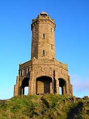
Jubilee Tower
The octagonal Jubilee Tower at grid reference 53°41'22.75"N 2°29'16.72"W on Beacon Hill overlooking the town of Darwen in Lancashire, England, was completed in 1898 to commemorate Queen Victoria's Diamond Jubilee and also to celebrate the victory of the local people for the right to access the moor...
on Darwen
Darwen
Darwen is a market town and civil parish located within Lancashire, England. Along with its northerly neighbour, Blackburn, it forms the Borough of Blackburn with Darwen — a unitary authority area...
Moor.
United Utilities
United Utilities
United Utilities Group PLC is the UK's largest listed water business. The Group owns and manages the regulated water and waste water network in the north west England, through it subsidiary United Utilities Water PLC , which is responsible for the vast majority of the group's assets and...
owns around 40% of the land for water catchment. The company operates four information centres at Rivington
Rivington
Rivington is a small village and civil parish of the Borough of Chorley, Lancashire, England, occupying . It is about southeast of Chorley and about northwest of Bolton. Rivington is situated on the fringe of the West Pennine Moors, at the foot of Rivington Pike...
, Jumbles Country Park
Jumbles Country Park
The Jumbles Country Park is a country park in the town of Bolton in Greater Manchester. It lies on the southern edge of the West Pennine Moors. It was opened on 11 March 1971 by HRH Queen Elizabeth II. The park is now owned and managed by United Utilities....
, Roddlesworth
Roddlesworth
Roddlesworth is the name of a hamlet in the parish of Withnell in Lancashire, England. It lies on the road connecting Preston with Bolton.The name is first encountered as Rodtholfeswrtha , meaning "the homestead of Hrothwulf"....
and Haslingden Grane
Haslingden Grane
thumb|right|300px|Lower Ogden Reservoir from Musbury HeightsHaslingden Grane is a glaciated valley lying to the west of Haslingden and in the north east of the West Pennine Moors. It is easily accessible via the B6232/A6077 Grane Road which links to the M65 motorway and the A56...
.
History
It is possible that MesolithicMesolithic
The Mesolithic is an archaeological concept used to refer to certain groups of archaeological cultures defined as falling between the Paleolithic and the Neolithic....
hunting camps existed on the moors but evidence is rare. The area was then covered by forest
which Neolithic and Bronze Age
Bronze Age
The Bronze Age is a period characterized by the use of copper and its alloy bronze as the chief hard materials in the manufacture of some implements and weapons. Chronologically, it stands between the Stone Age and Iron Age...
settlers began to clear. More forest was cleared by the Anglo-Saxon
Anglo-Saxon
Anglo-Saxon may refer to:* Anglo-Saxons, a group that invaded Britain** Old English, their language** Anglo-Saxon England, their history, one of various ships* White Anglo-Saxon Protestant, an ethnicity* Anglo-Saxon economy, modern macroeconomic term...
s and Viking
Viking
The term Viking is customarily used to refer to the Norse explorers, warriors, merchants, and pirates who raided, traded, explored and settled in wide areas of Europe, Asia and the North Atlantic islands from the late 8th to the mid-11th century.These Norsemen used their famed longships to...
s. Place names such as clough, fell and moss suggest they were named by Norse settlers. Parts of the moorland were within the Royal Hunting Forests in the Middle Ages
Middle Ages
The Middle Ages is a periodization of European history from the 5th century to the 15th century. The Middle Ages follows the fall of the Western Roman Empire in 476 and precedes the Early Modern Era. It is the middle period of a three-period division of Western history: Classic, Medieval and Modern...
. The landscape continued to change as a result of enclosures in the middle of the 16th century.
Cheetham Close
Cheetham Close
Cheetham Close is a megalith and scheduled ancient monument located in Lancashire, very close to the boundary with Greater Manchester, England. The megalith was in good condition until a farmer from Turton sledgehammered the circle in the 1870s...
above Edgworth
Edgworth
Edgworth is a small village within the Blackburn with Darwen borough of Lancashire, England. It is north east of North Turton between Broadhead Brook on the west and Quarlton Brook in the south east...
is the site of a destroyed Bronze Age megalith
Megalith
A megalith is a large stone that has been used to construct a structure or monument, either alone or together with other stones. Megalithic describes structures made of such large stones, utilizing an interlocking system without the use of mortar or cement.The word 'megalith' comes from the Ancient...
and is a scheduled ancient monument. On Anglezarke
Anglezarke
Anglezarke is a sparsely populated civil parish in the Borough of Chorley in Lancashire, England. It is dominated by reservoirs that were built to supply water to Liverpool, and a large expanse of moorland with evidence of Bronze Age settlements...
Moor are two prehistoric sites, Pikestones
Pikestones
Pikestones is the remains of a Neolithic Burial Cairn, located on Anglezarke moor in Lancashire, England. The site is approximately 150 feet long and 60 feet across at its widest point...
and Round Loaf
Round Loaf
Round Loaf is a Neolithic or Bronze Age tumulus on the West Pennine Moors on Anglezarke Moor, within the locale of Chorley in Lancashire, England.It is the largest of its type in the North West of England, dating back 3500 years...
, a landmark clearly visible from the route across Great Hill
Great Hill
Great Hill is a hill in Lancashire on Anglezarke Moor, between the towns of Chorley and Darwen. It is part of the West Pennine Moors and lies approximately 3 miles north of Winter Hill, which is the highest point in the area at 456 m ....
from White Coppice
White Coppice
White Coppice is a hamlet near Chorley, Lancashire, England. It was the most populated part of the township of Anglezarke in the 19th century. Close to the settlement in the early 19th century were quarries and small coal mines. The hamlet lies to the north of Anglezarke Reservoir in the Rivington...
. A burial mound from about 1500 BC was discovered on Winter Hill around 0.5 km west of the summit. Another site, 1 km west of the summit, at Noon Hill Saucer Tumulus
Tumulus
A tumulus is a mound of earth and stones raised over a grave or graves. Tumuli are also known as barrows, burial mounds, Hügelgrab or kurgans, and can be found throughout much of the world. A tumulus composed largely or entirely of stones is usually referred to as a cairn...
, is a burial site consisting of two concentric stonewalls which had two sets of burnt human bones, a broken urn containing more bones, two flint arrow heads and flint sacrificial knife in the centre. The site has been dated to around 1100 BC.
In 1690, lead was discovered in Lead Mines Clough at Anglezarke. The mines were expanded in the 1790s and copper and galena
Galena
Galena is the natural mineral form of lead sulfide. It is the most important lead ore mineral.Galena is one of the most abundant and widely distributed sulfide minerals. It crystallizes in the cubic crystal system often showing octahedral forms...
were also extracted. Witherite
Witherite
Witherite is a barium carbonate mineral, BaCO3, in the aragonite group. Witherite crystallizes in the orthorhombic system and virtually always is twinned. The mineral is colorless, milky white, grey, pale yellow, green, to pale brown. The specific gravity is 4.3, which is high for a translucent...
(barium carbonate) was discovered around 1700, and used as a glaze for porcelain
Porcelain
Porcelain is a ceramic material made by heating raw materials, generally including clay in the form of kaolin, in a kiln to temperatures between and...
. Stone was quarried at several sites including Anglezarke and used for building farmhouses, barns, mills and stone boundary walls. There were small coal mines on Winter Hill and Quarlton
Quarlton
Quarlton was a township of the civil and ecclesiastical parish of Bolton le Moors in the Salford hundred of Lancashire, England. It lay north east of Bolton.-Topynomy:...
.
Belmont was the site of a bleaching and dyeing
Dyeing
Dyeing is the process of adding color to textile products like fibers, yarns, and fabrics. Dyeing is normally done in a special solution containing dyes and particular chemical material. After dyeing, dye molecules have uncut Chemical bond with fiber molecules. The temperature and time controlling...
works, powered by water from Eagley Brook which powered mills along its valley. A reservoir was constructed, despite objections, requiring an Act of Parliament that stipulated two million gallons of water had to be released daily into Eagley Brook to sustain the industry that depended on it. Streams on the southern fringe of the moorland were utilised for water power and important for the bleaching and textile industries that grew up at Wallsuches
Wallsuches
Wallsuches is a small district of Horwich, Greater Manchester, England.-Etymology:The etymology of the place-name itself is unclear, although it is believed the name may be from Old English wella "stream" and soc "to soak", from Old English socian "to make wet/damp"...
, Horwich
Horwich
Horwich is a town and civil parish within the Metropolitan Borough of Bolton, in Greater Manchester, England. It is southeast of Chorley, northwest of Bolton and northwest from the city of Manchester. It lies at the southern edge of the West Pennine Moors with the M61 motorway close to the...
and Barrow Bridge.
Near the transmitter is Scotsman's Stump, an iron post with a plaque, a memorial to a Scottish salesman, George Henderson, who was shot on the moor by an unknown assailant in 1838. He was en-route to a local inn to meet a friend but failed to arrive. His friend searched and found him
fatally shot. A man was charged with the crime but not convicted.
A ranger on Winter Hill constructed two cairns on the moor to commemorate the alleged tragic death of two young men on the site many hundreds of years ago. Bolton Council demolished them claiming they were a safety hazard. He re-constructed them and successfully fought for them to remain. In the 1980s it was planned to excavate the site, but the plan was abandoned, so the truth behind the story is not known.
There have been two air disasters on the moors. Overlooking the valley near Lead Mines Clough is a war memorial commemorating the crew of an RAF Wellington bomber
Vickers Wellington
The Vickers Wellington was a British twin-engine, long range medium bomber designed in the mid-1930s at Brooklands in Weybridge, Surrey, by Vickers-Armstrongs' Chief Designer, R. K. Pierson. It was widely used as a night bomber in the early years of the Second World War, before being displaced as a...
that crashed there during the Second World War. On 27 February 1958 a commercial flight from Ronaldsway Airport
Isle of Man Airport
Isle of Man Airport , also known as Ronaldsway Airport and, in Manx, Purt Aer Vannin, is the main civilian airport on the Isle of Man. It is located in the south of the island at Ronaldsway near Castletown, southwest of Douglas, the island's capital. Along with the Isle of Man Sea Terminal, it is...
on the Isle of Man
Isle of Man
The Isle of Man , otherwise known simply as Mann , is a self-governing British Crown Dependency, located in the Irish Sea between the islands of Great Britain and Ireland, within the British Isles. The head of state is Queen Elizabeth II, who holds the title of Lord of Mann. The Lord of Mann is...
to Manchester Airport ended tragically on Winter Hill. The weather was atrocious and due to the poor visibility, heavy snow and remote location, only seven of the 42 people on board survived. The crash remains the area's worst air disaster. Plaques to commemorate this are mounted on the Arqiva
Arqiva
Arqiva is a telecommunications company which provides infrastructure and broadcast transmission facilities in the United Kingdom and Republic of Ireland. The present company, with headquarters located at Crawley Court in the village of Crawley, Hampshire, was formed by National Grid Wireless...
Winter Hill
Winter Hill transmitting station
The Winter Hill transmitting station is a broadcasting and telecommunications site situated on Winter Hill, at the southern boundary of the Borough of Chorley, and above Bolton in Greater Manchester, England...
building and at Ronaldsway Airport.
Geology and geography
The underlying geology is the Millstone GritMillstone Grit
Millstone Grit is the name given to any of a number of coarse-grained sandstones of Carboniferous age which occur in the Northern England. The name derives from its use in earlier times as a source of millstones for use principally in watermills...
series with sandstones and coarse gritstones separated by bands of shale
Shale
Shale is a fine-grained, clastic sedimentary rock composed of mud that is a mix of flakes of clay minerals and tiny fragments of other minerals, especially quartz and calcite. The ratio of clay to other minerals is variable. Shale is characterized by breaks along thin laminae or parallel layering...
. The area was covered by ice during the Ice Age and boulder clay deposited as the ice retreated. The rounded hill tops are millstone covered with shallow soil or peat
Peat
Peat is an accumulation of partially decayed vegetation matter or histosol. Peat forms in wetland bogs, moors, muskegs, pocosins, mires, and peat swamp forests. Peat is harvested as an important source of fuel in certain parts of the world...
above 400 metres. Lead
Lead
Lead is a main-group element in the carbon group with the symbol Pb and atomic number 82. Lead is a soft, malleable poor metal. It is also counted as one of the heavy metals. Metallic lead has a bluish-white color after being freshly cut, but it soon tarnishes to a dull grayish color when exposed...
, tin
Tin
Tin is a chemical element with the symbol Sn and atomic number 50. It is a main group metal in group 14 of the periodic table. Tin shows chemical similarity to both neighboring group 14 elements, germanium and lead and has two possible oxidation states, +2 and the slightly more stable +4...
and coal have been mined
Mining
Mining is the extraction of valuable minerals or other geological materials from the earth, from an ore body, vein or seam. The term also includes the removal of soil. Materials recovered by mining include base metals, precious metals, iron, uranium, coal, diamonds, limestone, oil shale, rock...
in the area. Witherite
Witherite
Witherite is a barium carbonate mineral, BaCO3, in the aragonite group. Witherite crystallizes in the orthorhombic system and virtually always is twinned. The mineral is colorless, milky white, grey, pale yellow, green, to pale brown. The specific gravity is 4.3, which is high for a translucent...
was discovered at White Coppice
White Coppice
White Coppice is a hamlet near Chorley, Lancashire, England. It was the most populated part of the township of Anglezarke in the 19th century. Close to the settlement in the early 19th century were quarries and small coal mines. The hamlet lies to the north of Anglezarke Reservoir in the Rivington...
.

Gritstone
Gritstone or Grit is a hard, coarse-grained, siliceous sandstone. This term is especially applied to such sandstones that are quarried for building material. British gritstone was used for millstones to mill flour, to grind wood into pulp for paper and for grindstones to sharpen blades. "Grit" is...
crags and steep escarpment
Escarpment
An escarpment is a steep slope or long cliff that occurs from erosion or faulting and separates two relatively level areas of differing elevations.-Description and variants:...
s creating dramatic landforms with "V"-shaped valleys drained by fast-flowing streams. The highest peak is Winter Hill at 456 metres (1,496.1 ft). The moors are incised by wooded valleys and cloughs; the largest is in the Roddlesworth
Roddlesworth
Roddlesworth is the name of a hamlet in the parish of Withnell in Lancashire, England. It lies on the road connecting Preston with Bolton.The name is first encountered as Rodtholfeswrtha , meaning "the homestead of Hrothwulf"....
valley near Tockholes
Tockholes
Tockholes is a village and civil parish which forms part of the Blackburn with Darwen unitary authority in the North west of England. Tockholes consists of the village of Tockholes itself and the Hamlet of Ryal Fold, and has a population of 454...
. There are small coniferous plantations, particularly around the reservoirs, but overall woodland cover is minimal.
The larger settlements are around the edges of the moors in the valleys, while the moors have scattered individual farmsteads built of local gritstone some of which have been abandoned or deserted. The predominant land use is for sheep farming. Unlike many areas of moorland in the north of England, the moors here are not managed for grouse
Grouse
Grouse are a group of birds from the order Galliformes. They are sometimes considered a family Tetraonidae, though the American Ornithologists' Union and many others include grouse as a subfamily Tetraoninae in the family Phasianidae...
shooting and consist largely of rough grassland and peat bog. There was a 50% loss of heather
Calluna
Calluna vulgaris is the sole species in the genus Calluna in the family Ericaceae. It is a low-growing perennial shrub growing to tall, or rarely to and taller, and is found widely in Europe and Asia Minor on acidic soils in open sunny situations and in moderate shade...
cover between 1946 and 1988.
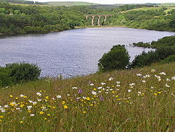
Reservoirs
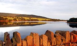
The Anglezarke
Anglezarke Reservoir
Anglezarke Reservoir is the largest reservoir in the Rivington chain to the west of Anglezarke in Lancashire, England. Anglezarke Reservoir has three embankments, the longest, the Charnock Embankment is 777 metres long and 9.45 metres high, the Knowsley Embankment is 219.5 metres long and 14...
, Upper Rivington
Upper Rivington Reservoir
Upper Rivington Reservoir is situated centrally in the Rivington chain of reservoirs, on the West Pennine Moors in Lancashire, England between Rivington and Anglezarke. The engineer for the Rivington reservoirs was Thomas Hawksley and construction took place between 1852 and 1857...
, Lower Rivington
Lower Rivington Reservoir
Lower Rivington Reservoir is at the end of the Rivington chain of reservoirs, with Upper Rivington Reservoir to the north, and Rivington Water Treatment Works to the south....
and Yarrow
Yarrow Reservoir
Yarrow Reservoir - named after the River Yarrow - is a reservoir in the Rivington chain in Anglezarke, Lancashire, England, and has a storage capacity second to Anglezarke Reservoir...
reservoirs were built to provide Liverpool
Liverpool
Liverpool is a city and metropolitan borough of Merseyside, England, along the eastern side of the Mersey Estuary. It was founded as a borough in 1207 and was granted city status in 1880...
with clean water. The 'Rivington Pike Scheme' was undertaken by Thomas Hawksley
Thomas Hawksley
Thomas Hawksley was an English civil engineer of the 19th century, particularly associated with water and gas engineering projects.The son of John Hawksley and Mary Whittle, and born in Arnold, near Nottingham on , Hawksley was largely self-taught from the age of 15 onwards, having at that point...
between 1850 and 1857 to construct five reservoirs. Water from two higher-level reservoirs, Rake Brook and Lower Ruddlesworth, was carried south in 'The Goit', a man-made channel through Heapey and White Coppice
White Coppice
White Coppice is a hamlet near Chorley, Lancashire, England. It was the most populated part of the township of Anglezarke in the 19th century. Close to the settlement in the early 19th century were quarries and small coal mines. The hamlet lies to the north of Anglezarke Reservoir in the Rivington...
connecting them to the reservoirs. The scheme was expanded in 1856 to include High Bullough Reservoir
High Bullough Reservoir
High Bullough reservoir is the oldest of all the reservoirs in the Rivington chain. Popular with walkers, it forms part of the Anglezarke trail, although it is also accessible from Manor House. Originally named as Chorley reservoir, it has since been disconnected from the rest of the system and...
, built in 1850 supplying water to Chorley. The Upper Roddlesworth Reservoir was built in 1867–75. Yarrow Reservoir
Yarrow Reservoir
Yarrow Reservoir - named after the River Yarrow - is a reservoir in the Rivington chain in Anglezarke, Lancashire, England, and has a storage capacity second to Anglezarke Reservoir...
was begun in 1867 and designed by Thomas Duncan, the Liverpool Borough Engineer.
The Rivington watershed
Drainage basin
A drainage basin is an extent or an area of land where surface water from rain and melting snow or ice converges to a single point, usually the exit of the basin, where the waters join another waterbody, such as a river, lake, reservoir, estuary, wetland, sea, or ocean...
comprises 10,000 acres (40 km²) of land and the average flow rate through the filter beds at Horwich
Horwich
Horwich is a town and civil parish within the Metropolitan Borough of Bolton, in Greater Manchester, England. It is southeast of Chorley, northwest of Bolton and northwest from the city of Manchester. It lies at the southern edge of the West Pennine Moors with the M61 motorway close to the...
is 8.96 million litres/day (2.24 million gallons/day).
To the east of the area can be found the separate chains of Belmont
Belmont Reservoir
Belmont Reservoir is a reservoir north of the small moorland village of Belmont, Lancashire, England fed by the Belmont Brook. It was built in 1826 by the Bolton Waterworks to supply water to the rapidly expanding town of Bolton. Belmont was once a thriving industrial centre for stone quarrying...
, Delph, Turton and Entwistle
Turton and Entwistle Reservoir
Turton and Entwistle Reservoir is a water reservoir in the town of Edgworth, Lancashire. The reservoir's existence is due to the Entwistle Dam. When constructed in 1832 the Entwistle Dam was the highest in Britain; it rises 108 feet from the base...
, Wayoh
Wayoh Reservoir
Wayoh Reservoir is a water reservoir in the town of Edgworth, Lancashire, England. It was completed on 28 April 1876 to supply water to Bolton. Wayoh, together with the Turton and Entwistle Reservoir, make up 50% of Bolton's drinking water....
and Jumbles
Jumbles Reservoir
The Jumbles Reservoir is a heavily modified, high alkalinity, shallow reservoir in North West England. It lies in Jumbles Country Park, in the valley of Bradshaw Brook, partly in the Metropolitan Borough of Bolton, Greater Manchester, and partly in Blackburn with Darwen, Lancashire...
reservoirs.
Situated in the northeast is Haslingden Grane
Haslingden Grane
thumb|right|300px|Lower Ogden Reservoir from Musbury HeightsHaslingden Grane is a glaciated valley lying to the west of Haslingden and in the north east of the West Pennine Moors. It is easily accessible via the B6232/A6077 Grane Road which links to the M65 motorway and the A56...
, a glaciated valley with three reservoirs, Calf Hey, Ogden and Holden Wood. There is a car park and information centre at Clough Head.
Access land
In 1896, a mass trespass took place on the moors following the sale of land to Colonel Ainsworth for shooting. He tried to prevent members of the public from using the public rights of way. Reports claim a crowd of 10,000 people gathered to be confronted by a barrier and the police, but the crowd literally threw the police officers over the fence and proceeded to march across the land. A large amount of open moorlandMoorland
Moorland or moor is a type of habitat, in the temperate grasslands, savannas, and shrublands biome, found in upland areas, characterised by low-growing vegetation on acidic soils and heavy fog...
has been made accessible due to the Countryside and Rights of Way Act 2000
Countryside and Rights of Way Act 2000
The Countryside and Rights of Way Act 2000 is a UK Act of Parliament which came into force on 30 November 2000.As of September 2007, not all sections of the Countryside and Rights of Way Act have yet come into force...
giving walkers the right to roam over the moorland. Much of this area is boggy and makes for difficult walking.
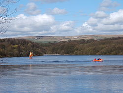
The area around High Bullough reservoir is a nature reserve on the Anglezarke trail. Mountain biking
Mountain biking
Mountain biking is a sport which consists of riding bicycles off-road, often over rough terrain, using specially adapted mountain bikes. Mountain bikes share similarities with other bikes, but incorporate features designed to enhance durability and performance in rough terrain.Mountain biking can...
has become popular since 2002, when the area was the setting for the biking events of the 2002 Commonwealth Games
2002 Commonwealth Games
The 2002 Commonwealth Games were held in Manchester, England from 25 July to 4 August 2002. The XVII Commonwealth Games was the largest multi-sport event ever to be held in the UK, eclipsing London's 1948 Summer Olympics in numbers of teams and athletes participating.After the 1996 Manchester...
.
Landmarks
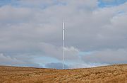
Winter Hill transmitting station
The Winter Hill transmitting station is a broadcasting and telecommunications site situated on Winter Hill, at the southern boundary of the Borough of Chorley, and above Bolton in Greater Manchester, England...
on Winter Hill extends to a height of 1014 feet (309.1 m) and is owned by Arqiva
Arqiva
Arqiva is a telecommunications company which provides infrastructure and broadcast transmission facilities in the United Kingdom and Republic of Ireland. The present company, with headquarters located at Crawley Court in the village of Crawley, Hampshire, was formed by National Grid Wireless...
. It carries analogue and digital radio transmissions and digital television transmissions of BBC TV, ITV, CH4, CH5, FREEVIEW, BBC radio and commercial radio services. This mast serves the North West region.
Most other masts and towers on the site are for mobile phones base stations, emergency services communications and PMR
Professional Mobile Radio
Professional mobile radio are field radio communications systems which use portable, mobile, base station, and dispatch console radios...
services and various microwave
Microwave
Microwaves, a subset of radio waves, have wavelengths ranging from as long as one meter to as short as one millimeter, or equivalently, with frequencies between 300 MHz and 300 GHz. This broad definition includes both UHF and EHF , and various sources use different boundaries...
links.
Rivington
Rivington is a small village and civil parish of the Borough of Chorley, Lancashire, England, occupying . It is about southeast of Chorley and about northwest of Bolton. Rivington is situated on the fringe of the West Pennine Moors, at the foot of Rivington Pike...
Pike was used as a beacon
Beacon
A beacon is an intentionally conspicuous device designed to attract attention to a specific location.Beacons can also be combined with semaphoric or other indicators to provide important information, such as the status of an airport, by the colour and rotational pattern of its airport beacon, or of...
on 19 July 1588, when it was lit to warn the population that the Spanish Armada
Spanish Armada
This article refers to the Battle of Gravelines, for the modern navy of Spain, see Spanish NavyThe Spanish Armada was the Spanish fleet that sailed against England under the command of the Duke of Medina Sidonia in 1588, with the intention of overthrowing Elizabeth I of England to stop English...
had been sighted off The Lizard
The Lizard
The Lizard is a peninsula in south Cornwall, England, United Kingdom. The most southerly point of the British mainland is near Lizard Point at ....
in Cornwall
Cornwall
Cornwall is a unitary authority and ceremonial county of England, within the United Kingdom. It is bordered to the north and west by the Celtic Sea, to the south by the English Channel, and to the east by the county of Devon, over the River Tamar. Cornwall has a population of , and covers an area of...
. A beacon was lit to mark the end of the Great War in 1918, the coronations of George V
George V of the United Kingdom
George V was King of the United Kingdom and the British Dominions, and Emperor of India, from 6 May 1910 through the First World War until his death in 1936....
and Elizabeth II and the Royal wedding in 1981. The tower on top of the Pike was built as a shelter commissioned by John Andrews of Rivington Hall
Rivington Hall
Rivington Hall is a Grade II* Listed building located in Rivington, Lancashire, England. It was the manor house for the Lords of the Manor of Rivington. The hall is of various builds as successor to a fifteenth-century timber-framed courtyard house that was built near to the present building of...
in 1733. It fell out of use when the estate was bought by William Lever in 1900. It is a Grade-II-listed building.
The octagonal Jubilee Tower
Jubilee Tower
The octagonal Jubilee Tower at grid reference 53°41'22.75"N 2°29'16.72"W on Beacon Hill overlooking the town of Darwen in Lancashire, England, was completed in 1898 to commemorate Queen Victoria's Diamond Jubilee and also to celebrate the victory of the local people for the right to access the moor...
on Beacon Hill overlooking the town of Darwen was completed in 1898 to commemorate Queen Victoria's Diamond Jubilee and to celebrate the victory of the local people for the right to access the moor. The tower is often referred to as "Darwen Tower". It is 85 ft (25.9 m) in height, and there is access to the top via the internal staircase from where Yorkshire
Yorkshire
Yorkshire is a historic county of northern England and the largest in the United Kingdom. Because of its great size in comparison to other English counties, functions have been increasingly undertaken over time by its subdivisions, which have also been subject to periodic reform...
, Morecambe Bay
Morecambe Bay
Morecambe Bay is a large bay in northwest England, nearly due east of the Isle of Man and just to the south of the Lake District National Park. It is the largest expanse of intertidal mudflats and sand in the United Kingdom, covering a total area of 310 km².-Natural features:The rivers Leven,...
, Lancashire
Lancashire
Lancashire is a non-metropolitan county of historic origin in the North West of England. It takes its name from the city of Lancaster, and is sometimes known as the County of Lancaster. Although Lancaster is still considered to be the county town, Lancashire County Council is based in Preston...
, Cumbria
Cumbria
Cumbria , is a non-metropolitan county in North West England. The county and Cumbria County Council, its local authority, came into existence in 1974 after the passage of the Local Government Act 1972. Cumbria's largest settlement and county town is Carlisle. It consists of six districts, and in...
, and surrounding moorland can be seen. On rare occasions, in favourable weather conditions, it is possible see the Isle of Man
Isle of Man
The Isle of Man , otherwise known simply as Mann , is a self-governing British Crown Dependency, located in the Irish Sea between the islands of Great Britain and Ireland, within the British Isles. The head of state is Queen Elizabeth II, who holds the title of Lord of Mann. The Lord of Mann is...
to the northwest.
The Peel Tower
Peel Monument
The memorial tower to Sir Robert Peel high above Ramsbottom was planned and erected at the same time as Bury was preparing its statue to the then recently deceased statesman who was born in Bury....
stands on Holcombe Hill as a memorial to the former Prime Minister. It is visible from miles around and its 148 steps can be climbed when the tower is open.
Wildlife and habitats
The West Pennine Moors and surrounding farmland have a rich and often undervalued level of biodiversityBiodiversity
Biodiversity is the degree of variation of life forms within a given ecosystem, biome, or an entire planet. Biodiversity is a measure of the health of ecosystems. Biodiversity is in part a function of climate. In terrestrial habitats, tropical regions are typically rich whereas polar regions...
.
On the unenclosed moorland
Moorland
Moorland or moor is a type of habitat, in the temperate grasslands, savannas, and shrublands biome, found in upland areas, characterised by low-growing vegetation on acidic soils and heavy fog...
, there are extensive areas of blanket bog
Blanket bog
Blanket bog or blanket mire is an area of peatland, forming where there is a climate of high rainfall and a low level of evapotranspiration, allowing peat to develop not only in wet hollows but over large expanses of undulating ground. The blanketing of the ground with a variable depth of peat...
on deep peat
Peat
Peat is an accumulation of partially decayed vegetation matter or histosol. Peat forms in wetland bogs, moors, muskegs, pocosins, mires, and peat swamp forests. Peat is harvested as an important source of fuel in certain parts of the world...
soils. Although much modified by grazing, burning and drainage, and in places dominated by purple moor-grass, characteristic species such as cotton-grass, heather, cross-leaved heath, cranberry and many species of Sphagnum
Sphagnum
Sphagnum is a genus of between 151 and 350 species of mosses commonly called peat moss, due to its prevalence in peat bogs and mires. A distinction is made between sphagnum moss, the live moss growing on top of a peat bog on one hand, and sphagnum peat moss or sphagnum peat on the other, the...
moss are well represented along with restricted plants such as bog rosemary. Elsewhere on the moorland there are areas of upland heath, acid grassland and upland flushes. Moorland birds include Peregrine Falcon
Peregrine Falcon
The Peregrine Falcon , also known as the Peregrine, and historically as the Duck Hawk in North America, is a widespread bird of prey in the family Falconidae. A large, crow-sized falcon, it has a blue-gray back, barred white underparts, and a black head and "moustache"...
, Merlin
Merlin (bird)
The Merlin is a small species of falcon from the Northern Hemisphere. A bird of prey once known colloquially as a pigeon hawk in North America, the Merlin breeds in the northern Holarctic; some migrate to subtropical and northern tropical regions in winter.-European and North American...
, Dunlin
Dunlin
The Dunlin, Calidris alpina, is a small wader, sometimes separated with the other "stints" in Erolia. It is a circumpolar breeder in Arctic or subarctic regions. Birds that breed in northern Europe and Asia are long-distance migrants, wintering south to Africa, southeast Asia and the Middle East...
, Wheatear
Northern Wheatear
The Northern Wheatear or Wheatear is a small passerine bird that was formerly classed as a member of the thrush family Turdidae, but is now more generally considered to be an Old World flycatcher, Muscicapidae...
, Short-eared Owl
Short-eared Owl
The Short-eared Owl is a species of typical owl . In Scotland this species of owl is often referred to as a cataface, grass owl or short-horned hootlet. Owls belonging to genus Asio are known as the eared owls, as they have tufts of feathers resembling mammalian ears. These "ear" tufts may or may...
and Golden Plover
Eurasian Golden Plover
The European Golden Plover is a largish plover. This species is similar to two other golden plovers. American Golden Plover, Pluvialis dominiica, and Pacific Golden Plover, Pluvialis fulva, are both smaller, slimmer and relatively longer-legged than European Golden Plover, and both have grey...
. The moorlands of the West Pennine Moors have largely escaped the extensive planting of conifers suffered in some other parts of the northern uplands.
At lower altitudes, the landscape is characterised by pasture
Pasture
Pasture is land used for grazing. Pasture lands in the narrow sense are enclosed tracts of farmland, grazed by domesticated livestock, such as horses, cattle, sheep or swine. The vegetation of tended pasture, forage, consists mainly of grasses, with an interspersion of legumes and other forbs...
and meadows enclosed by dry stone
Dry stone
Dry stone is a building method by which structures are constructed from stones without any mortar to bind them together. Dry stone structures are stable because of their unique construction method, which is characterized by the presence of a load-bearing facade of carefully selected interlocking...
walls. Species-rich grassland is now restricted in both area and distribution, mostly to steeper valleys or cloughs where there are also some species-rich flushes, such as those at Oak Field SSSI. Some of the more improved pastures still retain populations of breeding wading birds such as Peewit or Northern Lapwing
Northern Lapwing
The Northern Lapwing , also known as the Peewit, Green Plover or just Lapwing, is a bird in the plover family. It is common through temperate Eurasia....
, Snipe
Common Snipe
The Common Snipe is a small, stocky wader native to the Old World. The breeding habitat is marshes, bogs, tundra and wet meadows throughout northern Europe and northern Asia...
and Curlew
Eurasian Curlew
The Eurasian Curlew, Numenius arquata, is a wader in the large family Scolopacidae. It is one of the most widespread of the curlews, breeding across temperate Europe and Asia...
, and particularly in the fields and margins around Belmont Reservoir there are Oystercatcher
Eurasian Oystercatcher
The Eurasian Oystercatcher Haematopus ostralegus, also known as the Common Pied Oystercatcher, or just Oystercatcher, is a wader in the oystercatcher bird family Haematopodidae. It is the most widespread of the oystercatchers, with three races breeding in western Europe, central Eurasia,...
, Redshank
Common Redshank
The Common Redshank or simply Redshank is an Eurasian wader in the large family Scolopacidae.- Description and systematics :...
and Common Sandpiper
Common Sandpiper
The Common Sandpiper is a small Palearctic wader. This bird and its American sister species, the Spotted Sandpiper , make up the genus Actitis. They are parapatric and replace each other geographically; stray birds of either species may settle down with breeders of the other and hybridize...
. The Reservoir itself has nationally important populations of Black-headed
Black-headed Gull
The Black-headed Gull is a small gull which breeds in much of Europe and Asia, and also in coastal eastern Canada. Most of the population is migratory, wintering further south, but some birds in the milder westernmost areas of Europe are resident...
and Mediterranean Gull
Mediterranean Gull
The Mediterranean Gull, Ichthyaetus melanocephalus, is a small gull which breeds almost entirely in Europe, mainly in the south east, especially around the Black Sea, and in central Turkey. There are colonies elsewhere in southern Europe, and this species has undergone a dramatic range expansion in...
s.
Native broad-leaved woodland is also a habitat restricted almost entirely to valleys (cloughs), though there are examples of upland oak woodland, ash woodland and wet woodland dominated by alder and/or willow, such as at Longworth Clough SSSI. Along many of the reservoir valleys there are extensive areas of broad-leaved and conifer plantation such as around Roddlesworth Reservoir and Turton and Entwistle Reservoirs.