
Chiltern Hills
Encyclopedia
The Chiltern Hills form a chalk
escarpment
in South East England. They are known locally as "the Chilterns". A large portion of the hill
s was designated officially as an Area of Outstanding Natural Beauty
in 1965.
in Oxfordshire
, through Buckinghamshire
, via Dunstable Downs
and Deacon Hill
in Bedfordshire
, to near Hitchin
in Hertfordshire
.
The boundary of the hills is clearly defined on the northwest side by the scarp
slope. The dip slope
, by its nature, merges with the landscape to the southeast. Similarly, the Thames provides a clear terminal to the southwest, whereas northeast of Luton
the hills decline slowly in prominence.
of the Chiltern Hills overlooks the Vale of Aylesbury, and approximately coincides with the southernmost extent of the ice sheet
during the last glacial maximum. The Chilterns are part of the Southern England Chalk Formation
which also includes Salisbury Plain
, Cranborne Chase
, the Isle of Wight
and the South Downs
, in the south. In the north, the chalk formations continue northeastwards across north Hertfordshire
, Norfolk
and the Lincolnshire Wolds
, finally ending as the Yorkshire Wolds
in a prominent escarpment, south of the Vale of Pickering
. The Southern England Chalk Formation
was deposited over the buried northwestern margin of the Anglo-Brabant Massif during the Upper Cretaceous. During this time, sources for siliciclastic
sediment had been eliminated due to the exceptionally high sea level. The formation is thinner though the Chiltern Hills than the chalk strata to the north and south and deposition was tectonically controlled, with the Lilley
Bottom structure playing a significant role at times. The Southern England Chalk Formation
, like the underlying Gault Clay
and Upper Greensand, is diachronous
.
During the late stages of the Alpine Orogeny
, as the African Plate
collided with Eurasian Plate
, Mesozoic
extensional structures, such as the Weald Basin
of southern England underwent structural inversion
. This phase of deformation tilted the chalk strata to the southeast in the area of the Chiltern Hills. The gently dipping beds of rock were eroded, forming an escarpment
.
Peak altitude is reached at 275 metres above sea level.
The chalk strata
are frequently interspersed with layers of flint
nodules
which apparently replaced chalk and infilled pore spaces early in the diagenetic history. Flint has been mined for millennia from the Chiltern Hills. They were first extracted for fabrication into flint axe
s in the Neolithic
period, then for knapping into flintlocks. Nodules are to be seen everywhere in the older houses as a construction material for walls.
 Their highest point is 267 m (876 ft) at Haddington Hill
near Wendover
in Buckinghamshire; a stone monument marks the summit
. The nearby Ivinghoe Beacon
is a more prominent hill, although it only stands 249 m (817 ft) above sea level
. It is the starting point of the Icknield Way Path
and the Ridgeway
long distance path, which follows the line of the Chilterns for many miles to the west, where they merge with the Wiltshire
downs and southern Cotswolds
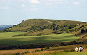
. To the east of Ivinghoe Beacon is Dunstable Downs, a steep section of the Chiltern scarp that is the site of the famous London Gliding Club
and Whipsnade Zoo. Near Wendover is Coombe Hill
which is 260 m (853 ft) above sea level.
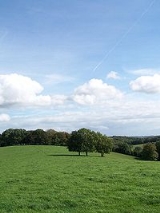
The more gently sloping country – the dip slope – to the southeast of the Chiltern scarp is also generally referred to as the Chilterns, containing much beech
woodland
and many village
s.
River
s that drain from the Chiltern Hills include the River Mimram
, River Lea, River Ver
, River Gade
, River Bulbourne
, River Chess
, River Misbourne
and River Wye
. These are classified as chalk stream
s, although the River Lea is degraded by water from road drains and sewage treatment works.
The opening credits of the BBC
sitcom The Vicar of Dibley
feature an aerial shot of the Stokenchurch Gap
. This is a major excavation which eases the M40 motorway
from the Chilterns into the Vale of Oxford
. It is between junctions 5 and 6. The chalk that forms the hills can clearly be seen on both sides of the cutting when driving on the motorway.
times, the Chiltern ridge provided a relatively safe and easily negotiable route across southern Iron Age England
, thus the Icknield Way
(one of England's ancient prehistoric trackways) follows the line of the hills. Its name comes from that of the Cilternsæte
, a tribe that occupied the area in early Anglo-Saxon period.
One of the principal Roman
settlements in the Roman province
of Britannia Superior
was sited at Verulamium
(now St Albans
) and there are significant Roman and Romano-British
remains in the area.
The Tudor
s had a hunting lodge in the Hemel Hempstead
area.
, rail
and canal
routes. These were funnelled through convenient valley
s (e.g., High Wycombe
, Hemel Hempstead
) and encouraged settlement and, later, commuter
housing.
The western edge of the Chilterns is notable for its ancient strip parishes, elongated parishes with villages in the flatter land below the escarpment and woodland and summer pastures in the higher land.
for millennia. The chalk has been quarried for the manufacture of cement
, and flint
for local building material. Beech
woods supplied furniture makers with quality hardwood
. The area was once (and still is to a lesser degree) renowned for its chair
-making industry, centred on the towns of Chesham
and High Wycombe (the nickname of Wycombe Wanderers Football Club is the Chairboys). The clean water
from the aquifer
is still used for public supply and the rivers and stream
s have fed watercress
beds. The chalk of the hills is an important aquifer, exploited to provide water supplies in the area; it has been suggested that over-exploitation has led to the disappearance of some streams.
.jpg) In a region short of building stone, local clay
In a region short of building stone, local clay
deposits and timber
provided the raw materials for brick
manufacture. Where available, flint
was also used for construction
; it is still used in modern building
s, although restricted to decoration to give a vernacular appearance.
Mediaeval strip parishes reflected the diversity of land from clay farmland
, through wooded slopes to downland. Their boundaries were often drawn to include a section of each type of land, resulting in an irregular county boundary between, say, Bedfordshire and Hertfordshire. These have tended to be smoothed out by successive reorganisations.
In modern times, as people have come to appreciate open country, the area has become a visitor destination and the National Trust
has acquired land to preserve its character, for example at Ashridge
, near Tring
. In places, with the reduction of sheep grazing
, action has been taken to maintain open downland by suppressing the natural growth of scrub and birch
woodland. In the 1920s and 1930s, the Youth Hostels Association established several youth hostels for people visiting the hills.
The hills have been used as a location for telecommunication relay stations such as Stokenchurch BT Tower
and that at Zouches Farm
.
and so enjoys special protection from major developments, which should not take place in such areas except in exceptional circumstances. This protection applies to major development proposals that raise issues of
national significance. In 2000 the government confirmed that the landscape qualities of AONBs are equivalent to those of National Parks, and that the protection given to both types of area by the land use planning system should also be equivalent.
In October 2010 the government confirmed proposals for the High Speed 2
rail link from London to Birmingham with a recommended route through the Chilterns AONB.
, the Chilterns - as other AONBs - do not possess their own planning authority
. The Chilterns Conservation Board has an advisory role on planning and development matters and seeks to influence the actions of local government by commenting upon planning application
s.
The local authorities (four County Councils, one Unitary Authority and ten District and Borough Councils) are expected to respect the area's status as a designated Area of Outstanding Natural Beauty.
. By established custom, Members of the British Parliament
, who are prohibited from resigning their seats directly, may apply for the Stewardship of the Chiltern Hundreds as a device to enable their departure from the House (see Resignation from the House of Commons).
Chalk
Chalk is a soft, white, porous sedimentary rock, a form of limestone composed of the mineral calcite. Calcite is calcium carbonate or CaCO3. It forms under reasonably deep marine conditions from the gradual accumulation of minute calcite plates shed from micro-organisms called coccolithophores....
escarpment
Escarpment
An escarpment is a steep slope or long cliff that occurs from erosion or faulting and separates two relatively level areas of differing elevations.-Description and variants:...
in South East England. They are known locally as "the Chilterns". A large portion of the hill
Hill
A hill is a landform that extends above the surrounding terrain. Hills often have a distinct summit, although in areas with scarp/dip topography a hill may refer to a particular section of flat terrain without a massive summit A hill is a landform that extends above the surrounding terrain. Hills...
s was designated officially as an Area of Outstanding Natural Beauty
Area of Outstanding Natural Beauty
An Area of Outstanding Natural Beauty is an area of countryside considered to have significant landscape value in England, Wales or Northern Ireland, that has been specially designated by the Countryside Agency on behalf of the United Kingdom government; the Countryside Council for Wales on...
in 1965.
Location
The Chilterns stretch in a 76 km (47.2 mi) southwest to northeast diagonal from Goring-on-ThamesGoring-On-Thames
Goring-on-Thames is a large village and civil parish on the River Thames in South Oxfordshire, about south of Wallingford.-Geography:...
in Oxfordshire
Oxfordshire
Oxfordshire is a county in the South East region of England, bordering on Warwickshire and Northamptonshire , Buckinghamshire , Berkshire , Wiltshire and Gloucestershire ....
, through Buckinghamshire
Buckinghamshire
Buckinghamshire is a ceremonial and non-metropolitan home county in South East England. The county town is Aylesbury, the largest town in the ceremonial county is Milton Keynes and largest town in the non-metropolitan county is High Wycombe....
, via Dunstable Downs
Dunstable Downs
Dunstable Downs are part of the Chiltern Hills, in southern Bedfordshire in England. They are a chalk escarpment forming the north-eastern reaches of the Chilterns...
and Deacon Hill
Pegsdon Hills
Pegsdon Hills are situated south and east of the hamlet of Pegsdon in the parish of Shillington in the English county of Bedfordshire. They form the north-eastern end of the Chiltern Hills. The most prominent hill is Deacon Hill....
in Bedfordshire
Bedfordshire
Bedfordshire is a ceremonial county of historic origin in England that forms part of the East of England region.It borders Cambridgeshire to the north-east, Northamptonshire to the north, Buckinghamshire to the west and Hertfordshire to the south-east....
, to near Hitchin
Hitchin
Hitchin is a town in Hertfordshire, England, with an estimated population of 30,360.-History:Hitchin is first noted as the central place of the Hicce people mentioned in a 7th century document, the Tribal Hidage. The tribal name is Brittonic rather than Old English and derives from *siccā, meaning...
in Hertfordshire
Hertfordshire
Hertfordshire is a ceremonial and non-metropolitan county in the East region of England. The county town is Hertford.The county is one of the Home Counties and lies inland, bordered by Greater London , Buckinghamshire , Bedfordshire , Cambridgeshire and...
.
The boundary of the hills is clearly defined on the northwest side by the scarp
Escarpment
An escarpment is a steep slope or long cliff that occurs from erosion or faulting and separates two relatively level areas of differing elevations.-Description and variants:...
slope. The dip slope
Dip slope
A dip slope is a geological formation often created by erosion of tilted strata. Dip slopes are found on homoclinal ridges with one side that is steep and irregular and another side, the dip slope, that is generally planar with a dip parallel to the bedding...
, by its nature, merges with the landscape to the southeast. Similarly, the Thames provides a clear terminal to the southwest, whereas northeast of Luton
Luton
Luton is a large town and unitary authority of Bedfordshire, England, 30 miles north of London. Luton and its near neighbours, Dunstable and Houghton Regis, form the Luton/Dunstable Urban Area with a population of about 250,000....
the hills decline slowly in prominence.
Geology
The chalk escarpmentEscarpment
An escarpment is a steep slope or long cliff that occurs from erosion or faulting and separates two relatively level areas of differing elevations.-Description and variants:...
of the Chiltern Hills overlooks the Vale of Aylesbury, and approximately coincides with the southernmost extent of the ice sheet
Ice sheet
An ice sheet is a mass of glacier ice that covers surrounding terrain and is greater than 50,000 km² , thus also known as continental glacier...
during the last glacial maximum. The Chilterns are part of the Southern England Chalk Formation
Southern England Chalk Formation
The Chalk Formation of Southern England is a system of chalk downland in the south of England. The formation is perhaps best known for Salisbury Plain, the location of Stonehenge, the Isle of Wight and the twin ridgeways of the North Downs and South Downs....
which also includes Salisbury Plain
Salisbury Plain
Salisbury Plain is a chalk plateau in central southern England covering . It is part of the Southern England Chalk Formation and largely lies within the county of Wiltshire, with a little in Hampshire. The plain is famous for its rich archaeology, including Stonehenge, one of England's best known...
, Cranborne Chase
Cranborne Chase
Cranborne Chase is a Chalk plateau in central southern England, straddling the counties Dorset, Hampshire and Wiltshire. The plateau is part of the English Chalk Formation and is adjacent to Salisbury Plain and the West Wiltshire Downs in the north, the Dorset Downs to the south west and the...
, the Isle of Wight
Isle of Wight
The Isle of Wight is a county and the largest island of England, located in the English Channel, on average about 2–4 miles off the south coast of the county of Hampshire, separated from the mainland by a strait called the Solent...
and the South Downs
South Downs
The South Downs is a range of chalk hills that extends for about across the south-eastern coastal counties of England from the Itchen Valley of Hampshire in the west to Beachy Head, near Eastbourne, East Sussex, in the east. It is bounded on its northern side by a steep escarpment, from whose...
, in the south. In the north, the chalk formations continue northeastwards across north Hertfordshire
Hertfordshire
Hertfordshire is a ceremonial and non-metropolitan county in the East region of England. The county town is Hertford.The county is one of the Home Counties and lies inland, bordered by Greater London , Buckinghamshire , Bedfordshire , Cambridgeshire and...
, Norfolk
Norfolk
Norfolk is a low-lying county in the East of England. It has borders with Lincolnshire to the west, Cambridgeshire to the west and southwest and Suffolk to the south. Its northern and eastern boundaries are the North Sea coast and to the north-west the county is bordered by The Wash. The county...
and the Lincolnshire Wolds
Lincolnshire Wolds
The Lincolnshire Wolds is a range of hills in the county of Lincolnshire, England. It is a designated Area of Outstanding Natural Beauty , and the highest area of land in eastern England between Yorkshire and Kent...
, finally ending as the Yorkshire Wolds
Yorkshire Wolds
The Yorkshire Wolds are low hills in the counties of East Riding of Yorkshire and North Yorkshire in northeastern England. The name also applies to the district in which the hills lie....
in a prominent escarpment, south of the Vale of Pickering
Vale of Pickering
The Vale of Pickering is a low-lying flat area of land in North Yorkshire, England. It is drained by the River Derwent. The landscape is rural with scattered villages and small market towns. It has been inhabited continuously from the Mesolithic period...
. The Southern England Chalk Formation
Southern England Chalk Formation
The Chalk Formation of Southern England is a system of chalk downland in the south of England. The formation is perhaps best known for Salisbury Plain, the location of Stonehenge, the Isle of Wight and the twin ridgeways of the North Downs and South Downs....
was deposited over the buried northwestern margin of the Anglo-Brabant Massif during the Upper Cretaceous. During this time, sources for siliciclastic
Siliciclastic
Siliciclastic rocks are clastic noncarbonate sedimentary rocks that are almost exclusively silica-bearing, either as forms of quartz or other silicate minerals. All siliciclastic rocks are formed by inorganic processes, or deposited through some mechanical process, such as stream deposits that are...
sediment had been eliminated due to the exceptionally high sea level. The formation is thinner though the Chiltern Hills than the chalk strata to the north and south and deposition was tectonically controlled, with the Lilley
Lilley, Hertfordshire
Lilley is a small village and civil parish in Hertfordshire which stands between Hitchin and Luton in England, on the highest ground and within some of the most striking scenery in the area. Telegraph Hill is just over 600 feet above sea level....
Bottom structure playing a significant role at times. The Southern England Chalk Formation
Southern England Chalk Formation
The Chalk Formation of Southern England is a system of chalk downland in the south of England. The formation is perhaps best known for Salisbury Plain, the location of Stonehenge, the Isle of Wight and the twin ridgeways of the North Downs and South Downs....
, like the underlying Gault Clay
Gault Clay
Gault is a clay formation of stiff blue clay deposited in a calm, fairly deep water marine environment during the Lower Cretaceous Period...
and Upper Greensand, is diachronous
Diachronous
A diachronous deposit in Geology is a sedimentary rock formation in which apparently similar material varies in age from place to place....
.
During the late stages of the Alpine Orogeny
Alpine orogeny
The Alpine orogeny is an orogenic phase in the Late Mesozoic and Tertiary that formed the mountain ranges of the Alpide belt...
, as the African Plate
African Plate
The African Plate is a tectonic plate which includes the continent of Africa, as well as oceanic crust which lies between the continent and various surrounding ocean ridges.-Boundaries:...
collided with Eurasian Plate
Eurasian Plate
The Eurasian Plate is a tectonic plate which includes most of the continent of Eurasia , with the notable exceptions of the Indian subcontinent, the Arabian subcontinent, and the area east of the Chersky Range in East Siberia...
, Mesozoic
Mesozoic
The Mesozoic era is an interval of geological time from about 250 million years ago to about 65 million years ago. It is often referred to as the age of reptiles because reptiles, namely dinosaurs, were the dominant terrestrial and marine vertebrates of the time...
extensional structures, such as the Weald Basin
Weald Basin
The Weald Basin was a major topographic feature of southern England and northern France from the Triassic to the late Cretaceous, its uplift in the late Cretaceous marked the formation of the Wealden Anticline....
of southern England underwent structural inversion
Inversion (geology)
In structural geology inversion or basin inversion relates to the relative uplift of a sedimentary basin or similar structure as a result of crustal shortening. This normally excludes uplift developed in the footwalls of later extensional faults, or uplift caused by mantle plumes...
. This phase of deformation tilted the chalk strata to the southeast in the area of the Chiltern Hills. The gently dipping beds of rock were eroded, forming an escarpment
Escarpment
An escarpment is a steep slope or long cliff that occurs from erosion or faulting and separates two relatively level areas of differing elevations.-Description and variants:...
.
Peak altitude is reached at 275 metres above sea level.
The chalk strata
Stratum
In geology and related fields, a stratum is a layer of sedimentary rock or soil with internally consistent characteristics that distinguish it from other layers...
are frequently interspersed with layers of flint
Flint
Flint is a hard, sedimentary cryptocrystalline form of the mineral quartz, categorized as a variety of chert. It occurs chiefly as nodules and masses in sedimentary rocks, such as chalks and limestones. Inside the nodule, flint is usually dark grey, black, green, white, or brown in colour, and...
nodules
Nodule (geology)
A nodule in petrology or mineralogy is a secondary structure, generally spherical or irregularly rounded in shape. Nodules are typically solid replacement bodies of chert or iron oxides formed during diagenesis of a sedimentary rock...
which apparently replaced chalk and infilled pore spaces early in the diagenetic history. Flint has been mined for millennia from the Chiltern Hills. They were first extracted for fabrication into flint axe
Flint axe
A flint axe was a Flint tool used during prehistoric times to perform a variety of tasks. These were at first just a cut piece of flint stone used as a hand axe but later wooden handles were attached to these axe heads. The stone exhibits a glass-like fracture similar to obsidian, and can be...
s in the Neolithic
Neolithic
The Neolithic Age, Era, or Period, or New Stone Age, was a period in the development of human technology, beginning about 9500 BC in some parts of the Middle East, and later in other parts of the world. It is traditionally considered as the last part of the Stone Age...
period, then for knapping into flintlocks. Nodules are to be seen everywhere in the older houses as a construction material for walls.
Physical characteristics
Haddington Hill
Haddington Hill is a hill in The Chilterns, and the highest point in the English county of Buckinghamshire. On the north-eastern flank is Coombe Hill, not to be confused with another Coombe Hill 4 kilometres to the south-west....
near Wendover
Wendover
Wendover is a market town that sits at the foot of the Chiltern Hills in Buckinghamshire, England. It is also a civil parish within Aylesbury Vale district...
in Buckinghamshire; a stone monument marks the summit
Summit (topography)
In topography, a summit is a point on a surface that is higher in elevation than all points immediately adjacent to it. Mathematically, a summit is a local maximum in elevation...
. The nearby Ivinghoe Beacon
Ivinghoe Beacon
Ivinghoe Beacon is a prominent hill and landmark in the Chiltern Hills, standing 233 m above sea level. It is situated close to the villages of Ivinghoe, Aldbury in Buckinghamshire, the Ashridge Estate, and the village of Little Gaddesden in Hertfordshire, and is managed and owned by the...
is a more prominent hill, although it only stands 249 m (817 ft) above sea level
Sea level
Mean sea level is a measure of the average height of the ocean's surface ; used as a standard in reckoning land elevation...
. It is the starting point of the Icknield Way Path
Icknield Way Path
Icknield Way Path is a long distance footpath in East Anglia, England.It connects with: Angles Way, , Chiltern Way, , Hertfordshire Chain Walk, Hertfordshire Way, Lea Valley Walk, Peddars Way, Ridgeway, Roman Road Link, Stour Valley Path and Swan's Way....
and the Ridgeway
The Ridgeway
thumb|right|thumb|The ancient tree-lined path winds over the downs countrysideThe Ridgeway is a ridgeway or ancient trackway described as Britain's oldest road...
long distance path, which follows the line of the Chilterns for many miles to the west, where they merge with the Wiltshire
Wiltshire
Wiltshire is a ceremonial county in South West England. It is landlocked and borders the counties of Dorset, Somerset, Hampshire, Gloucestershire, Oxfordshire and Berkshire. It contains the unitary authority of Swindon and covers...
downs and southern Cotswolds
Cotswolds
The Cotswolds are a range of hills in west-central England, sometimes called the Heart of England, an area across and long. The area has been designated as the Cotswold Area of Outstanding Natural Beauty...
. To the east of Ivinghoe Beacon is Dunstable Downs, a steep section of the Chiltern scarp that is the site of the famous London Gliding Club
London Gliding Club
The London Gliding Club is a private members' club, and was set up primarily to train pilots in powerless flight, and the skills necessary to fly cross country using nature's sources of energy. Aerobatics and instructor training is also available. The club provides gliding courses, one day courses...
and Whipsnade Zoo. Near Wendover is Coombe Hill
Coombe Hill, Buckinghamshire
Coombe Hill is a hill in The Chilterns, located next to the hamlet of Dunsmore, Buckinghamshire, England, near the small town of Wendover, and overlooking Aylesbury Vale...
which is 260 m (853 ft) above sea level.
The more gently sloping country – the dip slope – to the southeast of the Chiltern scarp is also generally referred to as the Chilterns, containing much beech
Beech
Beech is a genus of ten species of deciduous trees in the family Fagaceae, native to temperate Europe, Asia and North America.-Habit:...
woodland
Woodland
Ecologically, a woodland is a low-density forest forming open habitats with plenty of sunlight and limited shade. Woodlands may support an understory of shrubs and herbaceous plants including grasses. Woodland may form a transition to shrubland under drier conditions or during early stages of...
and many village
Village
A village is a clustered human settlement or community, larger than a hamlet with the population ranging from a few hundred to a few thousand , Though often located in rural areas, the term urban village is also applied to certain urban neighbourhoods, such as the West Village in Manhattan, New...
s.
River
River
A river is a natural watercourse, usually freshwater, flowing towards an ocean, a lake, a sea, or another river. In a few cases, a river simply flows into the ground or dries up completely before reaching another body of water. Small rivers may also be called by several other names, including...
s that drain from the Chiltern Hills include the River Mimram
River Mimram
The Mimram Valley is named after the River Mimram, which rises from a spring to the north of Whitwell, in North Hertfordshire, England, and makes its confluence with the River Lea near Horn's Mill in Hertford. At Whitwell there are cress beds which have existed since Roman times and these are fed...
, River Lea, River Ver
River Ver
The Ver is a river in Hertfordshire, England. The river begins in the grounds of Markyate Cell, and flows south for 12 miles alongside Watling Street through Flamstead, Redbourn, St Albans and Park Street, and joins the River Colne at Bricket Wood....
, River Gade
River Gade
The River Gade is a river running almost entirely though Hertfordshire. It rises from a spring in the chalk of the Chiltern Hills at Dagnall, Buckinghamshire and flows through Hemel Hempstead, Kings Langley and Croxley Green to Rickmansworth where it joins the The River Colne...
, River Bulbourne
River Bulbourne
The River Bulbourne is a river in Hertfordshire, England. It runs from Dudswell in Northchurch, through Berkhamsted , Bourne End and Boxmoor to where it joins the River Gade at Two Waters in Apsley near Hemel Hempstead. The total length of the river is 11 Km....
, River Chess
River Chess
The River Chess is a chalk stream which springs from Chesham, Buckinghamshire and runs through Buckinghamshire and Hertfordshire, in south-eastern England. The Chess, along with the Colne and Gade, gives rise to the name of the district of Three Rivers, in which it forms its confluence with the...
, River Misbourne
River Misbourne
The River Misbourne rises in a field on the outskirts of Great Missenden, Buckinghamshire, and flows down the Misbourne valley to join the River Colne just north of where the latter is crossed by the A40 Western Avenue....
and River Wye
River Wye, Buckinghamshire
The River Wye in Buckinghamshire is a river in England that rises in the Chiltern Hills of Buckinghamshire. It flows for around , through High Wycombe on its way down to Bourne End, where it meets the River Thames on the reach above Cookham Lock....
. These are classified as chalk stream
Chalk stream
Chalk streams have characteristics which set them apart from watercourses associated with other rock types.Aside from those with an interest in the geological and ecological disciplines, the term chalk stream is most widely used among a small group of fly fishermen ,...
s, although the River Lea is degraded by water from road drains and sewage treatment works.
The opening credits of the BBC
BBC
The British Broadcasting Corporation is a British public service broadcaster. Its headquarters is at Broadcasting House in the City of Westminster, London. It is the largest broadcaster in the world, with about 23,000 staff...
sitcom The Vicar of Dibley
The Vicar of Dibley
The Vicar of Dibley is a British sitcom created by Richard Curtis and written for its lead actress, Dawn French, by Curtis and Paul Mayhew-Archer, with contributions from Kit Hesketh-Harvey. It aired from 1994 to 2007...
feature an aerial shot of the Stokenchurch Gap
Stokenchurch Gap
The Stokenchurch Gap, also known as the Aston Rowant Cutting or Aston Hill cutting , or locally "The Canyon" is a steep chalk cutting, constructed through the Chiltern Hills in Oxfordshire, England during the early 1970s for the M40 motorway...
. This is a major excavation which eases the M40 motorway
M40 motorway
The M40 motorway is a motorway in the British transport network that forms a major part of the connection between London and Birmingham. Part of this road forms a section of the unsigned European route E05...
from the Chilterns into the Vale of Oxford
Oxford
The city of Oxford is the county town of Oxfordshire, England. The city, made prominent by its medieval university, has a population of just under 165,000, with 153,900 living within the district boundary. It lies about 50 miles north-west of London. The rivers Cherwell and Thames run through...
. It is between junctions 5 and 6. The chalk that forms the hills can clearly be seen on both sides of the cutting when driving on the motorway.
History
In pre-RomanRoman Britain
Roman Britain was the part of the island of Great Britain controlled by the Roman Empire from AD 43 until ca. AD 410.The Romans referred to the imperial province as Britannia, which eventually comprised all of the island of Great Britain south of the fluid frontier with Caledonia...
times, the Chiltern ridge provided a relatively safe and easily negotiable route across southern Iron Age England
British Iron Age
The British Iron Age is a conventional name used in the archaeology of Great Britain, referring to the prehistoric and protohistoric phases of the Iron-Age culture of the main island and the smaller islands, typically excluding prehistoric Ireland, and which had an independent Iron Age culture of...
, thus the Icknield Way
Icknield Way
The Icknield Way is an ancient trackway in southern England. It follows the chalk escarpment that includes the Berkshire Downs and Chiltern Hills.-Background:...
(one of England's ancient prehistoric trackways) follows the line of the hills. Its name comes from that of the Cilternsæte
Cilternsæte
The Cilternsæte was an Anglian tribe that occupied the Chilterns, probably in the 6th century AD.The Tribal Hidage valued their territory at 4,000 hides. This assessment is relatively large compared with those of some other tribes or central England, being 4% of the whole of Wessex...
, a tribe that occupied the area in early Anglo-Saxon period.
One of the principal Roman
Roman Empire
The Roman Empire was the post-Republican period of the ancient Roman civilization, characterised by an autocratic form of government and large territorial holdings in Europe and around the Mediterranean....
settlements in the Roman province
Roman province
In Ancient Rome, a province was the basic, and, until the Tetrarchy , largest territorial and administrative unit of the empire's territorial possessions outside of Italy...
of Britannia Superior
Britannia Superior
Britannia Superior was one of the provinces of Roman Britain created around 197 AD by Emperor Septimus Severus immediately after winning a civil war against Clodius Albinus, a war fought to determine who would be the next emperor. Albinus was the governor of Britannia during that civil war...
was sited at Verulamium
Verulamium
Verulamium was an ancient town in Roman Britain. It was sited in the southwest of the modern city of St Albans in Hertfordshire, Great Britain. A large portion of the Roman city remains unexcavated, being now park and agricultural land, though much has been built upon...
(now St Albans
St Albans
St Albans is a city in southern Hertfordshire, England, around north of central London, which forms the main urban area of the City and District of St Albans. It is a historic market town, and is now a sought-after dormitory town within the London commuter belt...
) and there are significant Roman and Romano-British
Romano-British
Romano-British culture describes the culture that arose in Britain under the Roman Empire following the Roman conquest of AD 43 and the creation of the province of Britannia. It arose as a fusion of the imported Roman culture with that of the indigenous Britons, a people of Celtic language and...
remains in the area.
The Tudor
Tudor dynasty
The Tudor dynasty or House of Tudor was a European royal house of Welsh origin that ruled the Kingdom of England and its realms, including the Lordship of Ireland, later the Kingdom of Ireland, from 1485 until 1603. Its first monarch was Henry Tudor, a descendant through his mother of a legitimised...
s had a hunting lodge in the Hemel Hempstead
Hemel Hempstead
Hemel Hempstead is a town in Hertfordshire in the East of England, to the north west of London and part of the Greater London Urban Area. The population at the 2001 Census was 81,143 ....
area.
Settlement
Until the coming of the railways and, later, the motor-car, the Chilterns were largely rural with country towns situated on the main routes through the hills. The position of the hills, northwest of London, has affected the routing of major roadRoad
A road is a thoroughfare, route, or way on land between two places, which typically has been paved or otherwise improved to allow travel by some conveyance, including a horse, cart, or motor vehicle. Roads consist of one, or sometimes two, roadways each with one or more lanes and also any...
, rail
Rail transport
Rail transport is a means of conveyance of passengers and goods by way of wheeled vehicles running on rail tracks. In contrast to road transport, where vehicles merely run on a prepared surface, rail vehicles are also directionally guided by the tracks they run on...
and canal
Canal
Canals are man-made channels for water. There are two types of canal:#Waterways: navigable transportation canals used for carrying ships and boats shipping goods and conveying people, further subdivided into two kinds:...
routes. These were funnelled through convenient valley
Valley
In geology, a valley or dale is a depression with predominant extent in one direction. A very deep river valley may be called a canyon or gorge.The terms U-shaped and V-shaped are descriptive terms of geography to characterize the form of valleys...
s (e.g., High Wycombe
High Wycombe
High Wycombe , commonly known as Wycombe and formally called Chepping Wycombe or Chipping Wycombe until 1946,is a large town in Buckinghamshire, England. It is west-north-west of Charing Cross in London; this figure is engraved on the Corn Market building in the centre of the town...
, Hemel Hempstead
Hemel Hempstead
Hemel Hempstead is a town in Hertfordshire in the East of England, to the north west of London and part of the Greater London Urban Area. The population at the 2001 Census was 81,143 ....
) and encouraged settlement and, later, commuter
Commuting
Commuting is regular travel between one's place of residence and place of work or full time study. It sometimes refers to any regular or often repeated traveling between locations when not work related.- History :...
housing.
The western edge of the Chilterns is notable for its ancient strip parishes, elongated parishes with villages in the flatter land below the escarpment and woodland and summer pastures in the higher land.
List of towns and villages within the overall Chilterns Hills area
- AldburyAldburyAldbury is a village and civil parish in Hertfordshire, England, near the borders of Bedfordshire and Buckinghamshire, in a valley close to Ashridge Park. The nearest town is Tring; Tring railway station, 1 mile west, is in the parish of Aldbury...
, AmershamAmershamAmersham is a market town and civil parish within Chiltern district in Buckinghamshire, England, 27 miles north west of London, in the Chiltern Hills. It is part of the London commuter belt....
, ApsleyApsleyApsley is a 19th century mill town in the county of Hertfordshire, England. It is a historic industrial site situated in a valley of the Chiltern Hills. It is positioned below the confluence of two permanent rivers, the Gade and Bulbourne. In an area of little surface water this was an obvious site...
, AshridgeAshridgeAshridge is an estate and house in Hertfordshire, England; part of the land stretches into Buckinghamshire and it is close to the Bedfordshire border. It is situated in the Chiltern Hills, an Area of Outstanding Natural Beauty, about two miles north of Berkhamsted and twenty miles north west of... - Barton-le-ClayBarton-le-ClayBarton-le-Clay is a large village and a civil parish located in Bedfordshire, England. The village has existed since at least 1066 and is mentioned in the Domesday Book...
, BeaconsfieldBeaconsfieldBeaconsfield is a market town and civil parish operating as a town council within the South Bucks district in Buckinghamshire, England. It lies northwest of Charing Cross in Central London, and south-east of the county town of Aylesbury...
, BellingdonBellingdonBellingdon the name deriving from the Anglo Saxon Bellingdenu or Bella's Valley is a village in the parish of Chartridge, in Buckinghamshire, England...
, BerkhamstedBerkhamsted-Climate:Berkhamsted experiences an oceanic climate similar to almost all of the United Kingdom.-Castle:...
, Bledlow RidgeBledlow RidgeBledlow Ridge is a village in the civil parish of Bledlow-cum-Saunderton in Buckinghamshire, England, population 940 . It is situated in the Chiltern Hills, about 4 miles SSW of Princes Risborough and on the road between the High Wycombe and Chinnor....
, BovingdonBovingdonBovingdon is a large village in the Chiltern Hills, in Hertfordshire, England, four miles south-west of Hemel Hempstead and it is a civil parish within the local authority area of Dacorum...
, BradenhamBradenham, BuckinghamshireBradenham is a village and civil parish within Wycombe district in Buckinghamshire, England. It is near Saunderton, off the main A4010 road between Princes Risborough and High Wycombe.- Village :...
, Breachwood Green, Buckland CommonBuckland CommonBuckland Common is a hamlet in Buckinghamshire, England. It is located in the Chiltern Hills, east of Wendover and the same distance south of Tring in Hertfordshire with which it shares a boundary... - CaddingtonCaddingtonCaddington is a village and civil parish in the Central Bedfordshire district of Bedfordshire, England. It is between the Dunstable/Luton urban area , and Hertfordshire ....
, Chalfont St GilesChalfont St GilesChalfont St Giles is a village and civil parish within Chiltern district in south east Buckinghamshire, England, on the edge of the Chilterns, 25 miles from London, and near Seer Green, Jordans, Chalfont St Peter, Little Chalfont and Amersham....
, Chalfont St PeterChalfont St PeterChalfont St Peter is a village and civil parish in Chiltern district in south-east Buckinghamshire, England. It is in a group of villages called The Chalfonts which also includes Chalfont St Giles and Little Chalfont. The villages lie between High Wycombe and Rickmansworth. Chalfont St Peter is...
, ChartridgeChartridgeChartridge is a village in Buckinghamshire, England situated 2 miles North West of Chesham.Chartridge is also the name of a civil parish in Chiltern District which also includes the village of Bellingdon and the hamlets of Pednor, Hundridge and Asheridge...
, CheshamCheshamChesham is a market town in the Chiltern Hills, Buckinghamshire, England. It is located 11 miles south-east of the county town of Aylesbury. Chesham is also a civil parish designated a town council within Chiltern district. It is situated in the Chess Valley and surrounded by farmland, as well as...
, ChinnorChinnorChinnor is a village and civil parish in South Oxfordshire about southeast of Thame. The village is a Spring line settlement on the Icknield Way below the Chiltern escarpment...
, Chiltern GreenChiltern GreenChiltern Green is a hamlet located in Bedfordshire, England.The settlement lent its name to Chiltern Green railway station, which was located in nearby New Mill End. The railway station closed in 1952. Today, London Luton Airport is located to the north west of Chiltern Green....
, Christmas CommonChristmas CommonChristmas Common is a hamlet in Watlington civil parish about south of Thame in Oxfordshire, close to the boundary with Buckinghamshire. The hamlet is above sea level on an escarpment of the Chiltern Hills. Because of its elevation, Christmas Common has two radio masts that are prominent local...
, CholesburyCholesburyCholesbury is a village in Buckinghamshire, England, on the border with Hertfordshire. It is situated in the Chiltern Hills, about east of Wendover, north of Chesham and from Berkhamsted.... - DunsmoreDunsmore, BuckinghamshireDunsmore is a hamlet in the parish of Ellesborough, in Buckinghamshire, England. It occupies a hilltop position in the Chiltern Hills about 2 miles south of Wendover...
, DunstableDunstableDunstable is a market town and civil parish located in Bedfordshire, England. It lies on the eastward tail spurs of the Chiltern Hills, 30 miles north of London. These geographical features form several steep chalk escarpments most noticeable when approaching Dunstable from the north.-Etymology:In... - EdlesboroughEdlesboroughEdlesborough is a village and is also a civil parish within Aylesbury Vale district in Buckinghamshire, England. It is adjacent to the village of Eaton Bray over the county boundary in Bedfordshire, about three miles WSW of Dunstable....
, EllesboroughEllesboroughEllesborough is a village and civil parish in Wycombe district in Buckinghamshire, England. The village is at the foot of the Chiltern Hills just to the south of the Vale of Aylesbury, two miles from Wendover and five miles from Aylesbury. It lies between Wendover and the village of Little Kimble... - FawleyFawley, BuckinghamshireFawley is a village and civil parish in Wycombe district in the south-western corner of Buckinghamshire, England. It is on the boundary between Buckinghamshire and Oxfordshire, about seven miles west of Great Marlow and north of Henley-on-Thames....
, FingestFingestFingest is a village in Buckinghamshire, England. It is in the Chiltern Hills near the border with Oxfordshire, about six miles WSW of High Wycombe. It lies in the civil parish of Hambleden....
, Flackwell HeathFlackwell HeathFlackwell Heath is a village in the civil parish of Chepping Wycombe on the outskirts of High Wycombe, Buckinghamshire England. It is at an elevation of about 150m as it sits on the top of one of the Chiltern Hills. It has a population of around 6000.-History:...
, FriethFriethFrieth is a village in the parish of Hambleden, in Buckinghamshire, England. It lies on the top of 'Frieth Hill', which is part of the chalk escarpments of the Chiltern Hills.... - Gerrards CrossGerrards CrossGerrards Cross is a village in Buckinghamshire, England. It is in the south of the county, near the border with Greater London, south of Chalfont St Peter. Gerrards Cross is also a civil parish within South Bucks district, which was known as the Beaconsfield district from 1974 to 1980...
, Goring-On-ThamesGoring-On-ThamesGoring-on-Thames is a large village and civil parish on the River Thames in South Oxfordshire, about south of Wallingford.-Geography:...
, Great KingshillGreat KingshillGreat Kingshill and Little Kingshill are small villages in the parishes of Hughenden and Little Missenden respectively in Buckinghamshire, England. They are located in the Chiltern Hills, about five miles west of Amersham and two and a half miles south of Great Missenden.The village name...
, Great MissendenGreat MissendenGreat Missenden is a large village in the Misbourne Valley in the Chiltern Hills in Buckinghamshire, England, situated between the towns of Amersham and Wendover. It closely adjoins the villages of Little Missenden and Prestwood. The narrow High Street is bypassed by the main A413 London to...
, Great HampdenGreat HampdenGreat and Little Hampden is a civil parish in Buckinghamshire, England, about three miles south-east of Princes Risborough. It incorporates the villages of Great Hampden and Little Hampden, and the hamlets of Green Hailey and Hampden Row...
, Great Offley - HaltonHalton, BuckinghamshireHalton is a small village and is also a civil parish within Aylesbury Vale district in Buckinghamshire, England about 2 miles from Wendover and 5 miles from Aylesbury. It lies just outside the Metropolitan Green Belt so it has not been protected from postwar housing development...
, HambledenHambledenHambleden is a small village and civil parish within Wycombe district in the south of Buckinghamshire, England. It is about four miles west of Marlow, and about three miles north east of Henley-on-Thames in Oxfordshire....
, HawridgeHawridgeHawridge, is a small village in the Chilterns in the county of Buckinghamshire, England and bordering the county boundary with Hertfordshire. It is from Chesham, from both Tring and Berkhamsted....
, Hemel HempsteadHemel HempsteadHemel Hempstead is a town in Hertfordshire in the East of England, to the north west of London and part of the Greater London Urban Area. The population at the 2001 Census was 81,143 ....
, Henley-on-ThamesHenley-on-ThamesHenley-on-Thames is a town and civil parish on the River Thames in South Oxfordshire, England, about 10 miles downstream and north-east from Reading, 10 miles upstream and west from Maidenhead...
, HextonHextonHexton is a small village and civil parish about six miles west of Hitchin in Hertfordshire, England.It stands in well wooded and hilly country adjacent to the Bedfordshire border. The church, dedicated to St Faith, is mediaeval with heavy 19th century restoration...
, High WycombeHigh WycombeHigh Wycombe , commonly known as Wycombe and formally called Chepping Wycombe or Chipping Wycombe until 1946,is a large town in Buckinghamshire, England. It is west-north-west of Charing Cross in London; this figure is engraved on the Corn Market building in the centre of the town...
, HitchinHitchinHitchin is a town in Hertfordshire, England, with an estimated population of 30,360.-History:Hitchin is first noted as the central place of the Hicce people mentioned in a 7th century document, the Tribal Hidage. The tribal name is Brittonic rather than Old English and derives from *siccā, meaning...
, HughendenHughenden ValleyHughenden Valley is an extensive village and civil parish within Wycombe district in Buckinghamshire, England, just to the north of High Wycombe... - IbstoneIbstoneIbstone is a village and civil parish within Wycombe district in Buckinghamshire, England. It is in the Chiltern Hills on the border with Oxfordshire, about two miles south of Stokenchurch....
- Jordans
- KensworthKensworthKensworth is a village and civil parish located in the Central Bedfordshire district of Bedfordshire, England. The parish is located on the edge of Dunstable Downs, and includes the hamlets of California and Kensworth Lynch....
- Lane EndLane End, BuckinghamshireLane End is a village and civil parish within Wycombe district in Buckinghamshire, England. It is just south of the M40 from High Wycombe, about two miles west of Booker. The village is twinned with Saint-Pierre-d'Oléron in France....
, Ley HillLey HillFor the area in Birmingham, England see Ley Hill, BirminghamLey Hill is a Chiltern village on the Bucks/Herts border near the town of Chesham in the south-east England. It is part of the civil parish of Latimer, and comes under Chiltern District Council in the County of Buckinghamshire. Ley Hill...
, Little ChalfontLittle ChalfontLittle Chalfont is a village and civil parish in Chiltern district in south east Buckinghamshire, England. It is situated in a small group of villages called The Chalfonts which also consists of Chalfont St Giles and Chalfont St Peter...
, Little Kingshill, Little MissendenLittle MissendenLittle Missenden is a village in Buckinghamshire, England. It is in the Chiltern Hills, about three miles south east of Great Missenden, three miles west of Amersham.The toponym "Missenden" is derived from the Old English for "valley where marsh plants grow"...
, Little GaddesdenLittle GaddesdenLittle Gaddesden is a village and civil parish in the English county of Hertfordshire three miles north of Berkhamsted. As well as Little Gaddesden village , the parish contains the settlements of Ashridge , Hudnall , and part of Ringshall .Part of the parish was formerly in Buckinghamshire...
, LilleyLilley, HertfordshireLilley is a small village and civil parish in Hertfordshire which stands between Hitchin and Luton in England, on the highest ground and within some of the most striking scenery in the area. Telegraph Hill is just over 600 feet above sea level....
, LutonLutonLuton is a large town and unitary authority of Bedfordshire, England, 30 miles north of London. Luton and its near neighbours, Dunstable and Houghton Regis, form the Luton/Dunstable Urban Area with a population of about 250,000.... - MarkyateMarkyateMarkyate is a village and civil parish in north-west Hertfordshire close to the border with Bedfordshire and Buckinghamshire.-Geography:Having a number of former names, including Markyate Street and Mergyate, it has been a part of all three counties since it was first founded as the county...
, MarlowMarlow, BuckinghamshireMarlow is a town and civil parish within Wycombe district in south Buckinghamshire, England...
, MedmenhamMedmenhamMedmenham is a village and civil parish in the Wycombe district of Buckinghamshire, England. It is on the River Thames, about three and a half miles southwest of Marlow and three miles east of Henley-on-Thames.... - NaphillNaphillNaphill is a village in the parish of Hughenden Valley, in Buckinghamshire, England. It is north-west of Hughenden, on the ridge of one of the Chiltern Hills, and is adjacent to the village of Walter's Ash.The origin of its name is obscure...
, NettlebedNettlebedNettlebed is a village in England in the Chiltern Hills about northwest of Henley-on-Thames in Oxfordshire and southeast of Wallingford.-History:Archaeological finds show that the area around Nettlebed has been inhabited since Palaeolithic times....
, Nuffield, OxfordshireNuffield, OxfordshireNuffield is a village and civil parish in the Chiltern Hills in South Oxfordshire, just over east of Wallingford.-History:The ancient Ridgeway path runs through the village. The section of the Ridgeway west of the village follows the ancient Grim's Ditch.... - PishillPishillPishill is a hamlet in Pishill with Stonor civil parish about north of Henley-on-Thames in South Oxfordshire. It is in the Stonor valley in the Chiltern Hills about above sea level.-History:...
, Princes RisboroughPrinces RisboroughPrinces Risborough is a small town in Buckinghamshire, England, about 9 miles south of Aylesbury and 8 miles north west of High Wycombe. Bledlow lies to the west and Monks Risborough to the east. It lies at the foot of the Chiltern Hills, at the north end of a gap or pass through the Chilterns,...
, PrestwoodPrestwoodPrestwood is a village in Buckinghamshire, England. It is located in the Chiltern Hills, about a mile west of Great Missenden, four miles north of High Wycombe.-Early history and creation of parish:...
, RedbournRedbournRedbourn is a village and civil parish in Hertfordshire, United Kingdom, lying on Watling Street, 3 miles from Harpenden, 4 miles from St Albans and 5 miles from Hemel Hempstead. It has a population of around 6,000.-History:... - SkirmettSkirmettSkirmett is a hamlet in the parish of Hambleden, in Buckinghamshire, England. It lies in the Hambleden Valley in the Chiltern Hills, between the villages of Hambleden and Fingest....
, SharpenhoeSharpenhoeSharpenhoe is a small village in Bedfordshire, England, at the foot of the hills known as the Sharpenhoe Clappers, which are within the Chilterns AONB.- Transport :...
, ShiplakeShiplakeShiplake is a village and civil parish about south of Henley-on-Thames in Oxfordshire, England on the River Thames.-History:The Church of England parish church of St. Peter and St. Paul dates from at least the 13th century, but in 1869 the Gothic Revival architect G.E. Street rebuilt the chancel,...
, SouthendSouthend, BuckinghamshireSouthend is a hamlet, in the civil parish of Turville near to the village of the same name in Buckinghamshire, England. It lies in the Chiltern Hills at an elevation of 188m near the Oxfordshire border above and to the west of the Hambleden Valley....
, SpeenSpeen, BuckinghamshireSpeen is a village in the parish of Princes Risborough, in Buckinghamshire, England. It is located in the Chiltern Hills, about three miles south east of the main town.The village name is Anglo Saxon in origin, and means 'wood chips'...
, St LeonardsSt Leonards, BuckinghamshireSt Leonards is a small village in the Chiltern Hills in Buckinghamshire, England. It is 3 miles east of Wendover and 4 miles south of Tring, Hertfordshire...
, StokenchurchStokenchurchStokenchurch is a village and civil parish within Wycombe district in Buckinghamshire England. It is in the Chiltern Hills, about south of Chinnor in Oxfordshire and west of High Wycombe. The village is a popular place to live, due to its rural location and ease of access to London and Birmingham...
, StonorStonorStonor Park is a private park and historic country house at Stonor, about north of Henley-on-Thames in Oxfordshire, England, close to the county boundary with Buckinghamshire.-Setting:...
, Streatley (Beds)Streatley, BedfordshireStreatley is a village and civil parish in the Central Bedfordshire district of Bedfordshire, England.-Geography:Streatley is situated just to the west of the A6, and is the first village on the A6 north of Luton, being about north of central Luton...
.StudhamStudhamStudham is a village and civil parish in the county of Bedfordshire. It has a population of 1,125. The parish bounds to the south the Buckinghamshire border, and to the east is the Hertfordshire border. The village lies in the wooded south facing rolls of the Chiltern Hills... - ThameThameThame is a town and civil parish in Oxfordshire, about southwest of the Buckinghamshire town of Aylesbury. It derives its toponym from the River Thame which flows past the north side of the town....
, TringTringTring is a small market town and also a civil parish in the Chiltern Hills in Hertfordshire, England. Situated north-west of London and linked to London by the old Roman road of Akeman Street, by the modern A41, by the Grand Union Canal and by rail lines to Euston Station, Tring is now largely a...
, TurvilleTurvilleTurville is a village and civil parish within Wycombe district in Buckinghamshire, England. It is located in the Chiltern Hills, about five miles west of High Wycombe and five miles north of Henley-on-Thames.... - Walter's Ash, WatlingtonWatlington, OxfordshireWatlington is a market town and civil parish about south of Thame in Oxfordshire. The parish includes the hamlets of Christmas Common and Greenfield, both of which are in the Chiltern Hills. The M40 motorway is from Watlington.-History:...
, WendoverWendoverWendover is a market town that sits at the foot of the Chiltern Hills in Buckinghamshire, England. It is also a civil parish within Aylesbury Vale district...
, West WycombeWest WycombeWest Wycombe is a small village situated along the A40 road, due three miles west of High Wycombe, Buckinghamshire, England.The historic village is largely a National Trust property and receives a large annual influx of tourists - being the site of West Wycombe Park, West Wycombe Caves and the...
, WhitwellWhitwell, HertfordshireWhitwell is a village in the parish of St Paul's Walden about six miles south of Hitchin in Hertfordshire, England. Situated on a tableland, a spur of the Chilterns, Whitwell is about 400 feet above sea level. The soil is mostly clay with flints....
, WhipsnadeWhipsnadeWhipsnade is a small village and civil parish in the county of Bedfordshire. It lies on the eastward tail spurs of the Chiltern Hills, about 2.5 miles South-South-West of Dunstable...
, WiggintonWigginton, HertfordshireWigginton is a large village and civil parish running north-south and perched at on the edge of the Chiltern Hills in the county of Hertfordshire and aside the border with Buckinghamshire...
, WoodcoteWoodcoteWoodcote is a village in the civil parish in South Oxfordshire, about southeast of Wallingford and about northwest of Reading, Berkshire. It is in the Chiltern Hills, and the highest part of the village is above sea level....
Strip parishes partly in the Chilterns
- Bedfordshire: Eaton Bray, ToddingtonToddington, BedfordshireToddington is a large village and civil parish in the county of Bedfordshire, England which is situated 5 miles NNW of Luton, north of Dunstable, south west of Woburn and 35 miles NNW of London on the A5120 and B579. It is 0.5 miles from Junction 12 of the M1 motorway and lends its...
, TotternhoeTotternhoeTotternhoe is a village and civil parish in the Manshead hundred of the county of Bedfordshire, England.-Overview:Totternhoe is an ancient village in southern Bedfordshire, near Dunstable and Leighton Buzzard. Totternhoe Knolls has been a fort for many peoples including Romans and Normans... - Buckinghamshire: Aston ClintonAston ClintonAston Clinton is a village and civil parish close to the main A41 road in Buckinghamshire, England between Tring and Aylesbury. The parish covers and is about east of Aylesbury. The village is at the foot of the chalk escarpment of the Chiltern Hills at the junction of the pre-historic track the...
, BledlowBledlowBledlow is a village in the civil parish of Bledlow-cum-Saunderton in Buckinghamshire, England. It is situated about a mile and a half WSW of Princes Risborough, and on the border with Oxfordshire....
, BucklandBuckland, BuckinghamshireBuckland is a village and civil parish in Aylesbury Vale district in Buckinghamshire, England. The village near the boundary with Hertfordshire, close to Aston Clinton.-History:...
, Drayton BeauchampDrayton BeauchampDrayton Beauchamp is a village and civil parish within Aylesbury Vale district in Buckinghamshire, England. It is in the east of the county, near the border boundary Hertfordshire, about six miles from Aylesbury and two miles from Tring.-History:...
, Great Kimble, HorsendenHorsendenHorsenden is a hamlet in Wycombe district, Buckinghamshire, England and is in the civil parish of Longwick-cum-Ilmer. It is one mile from Princes Risborough and seven miles south of Aylesbury and three miles east of Chinnor in Oxfordshire...
, The Lee, MarsworthMarsworthMarsworth is a village and also a civil parish within Aylesbury Vale district in Buckinghamshire, England. It is about two miles north of Tring, in Hertfordshire and six miles east of Aylesbury.-Early history:...
, Monks RisboroughMonks RisboroughMonks Risborough is a village and ecclesiastical parish in Buckinghamshire, England, lying between Princes Risborough and Great Kimble. The village lies at the foot of the northern scarp of the Chiltern Hills...
, PitstonePitstonePitstone is a village and civil parish within the Aylesbury Vale district of Buckinghamshire, England. It is located at the foot of the Chiltern Hills, about seven miles east of Aylesbury and six miles south of Leighton Buzzard...
, Princes RisboroughPrinces RisboroughPrinces Risborough is a small town in Buckinghamshire, England, about 9 miles south of Aylesbury and 8 miles north west of High Wycombe. Bledlow lies to the west and Monks Risborough to the east. It lies at the foot of the Chiltern Hills, at the north end of a gap or pass through the Chilterns,...
, SaundertonSaundertonSaunderton is a village in Buckinghamshire, England. It is located in a valley of the Chiltern Hills, about three and a half miles north west of High Wycombe, four miles south of Princes Risborough. It lies on the main A4010 road, and has a station on the Chiltern Main Line between the two...
, Stoke MandevilleStoke MandevilleStoke Mandeville is a village and also a civil parish within Aylesbury Vale district to the south-east of Aylesbury in the county of Buckinghamshire, England. Although a separate civil parish, the village falls within the Aylesbury Urban Area...
, Weston TurvilleWeston TurvilleWeston Turville is a village and also a civil parish within Aylesbury Vale district in Buckinghamshire, England. It is located about a mile and a half south east of Aylesbury and the parish is bisected across the top by Akeman Street.... - Hertfordshire: TringTringTring is a small market town and also a civil parish in the Chiltern Hills in Hertfordshire, England. Situated north-west of London and linked to London by the old Roman road of Akeman Street, by the modern A41, by the Grand Union Canal and by rail lines to Euston Station, Tring is now largely a...
, WiggintonWigginton, HertfordshireWigginton is a large village and civil parish running north-south and perched at on the edge of the Chiltern Hills in the county of Hertfordshire and aside the border with Buckinghamshire... - Oxfordshire: Aston RowantAston RowantAston Rowant is a village and civil parish about south of Thame in South Oxfordshire, England. The parish includes the villages of Aston Rowant and Kingston Blount, and adjoins Buckinghamshire to the southeast....
, CheckendonCheckendonCheckendon is a village and civil parish about west of Henley-on-Thames in South Oxfordshire, England.-Parish church:The Church of England parish church of Saint Peter and Saint Paul is a 12th century Norman building...
, ChinnorChinnorChinnor is a village and civil parish in South Oxfordshire about southeast of Thame. The village is a Spring line settlement on the Icknield Way below the Chiltern escarpment...
, IpsdenIpsdenIpsden is a village and civil parish in the Chiltern Hills in South Oxfordshire, about southeast of Wallingford.-Parish church:The Church of England parish church of Saint Mary the Virgin was built late in the 12th century as a chapelry of North Stoke...
, LewknorLewknorLewknor is a village and civil parish south of Thame in Oxfordshire. The civil parish includes the village of Postcombe.-Iron Age and Roman periods:...
, MongewellMongewellMongewell is a village in the civil parish of Crowmarsh, about south of Wallingford in Oxfordshire. Mongewell is on the east bank of the Thames, linked with the west bank at Winterbrook by the nearby Winterbrook Bridge...
, Newnham MurrenNewnham MurrenNewnham Murren is a village in the Thames Valley in South Oxfordshire, about east of the market town of Wallingford. Newnham Murren is in the civil parish of Crowmarsh and is now contiguous with the village of Crowmarsh Gifford.-History:...
, NuffieldNuffield, OxfordshireNuffield is a village and civil parish in the Chiltern Hills in South Oxfordshire, just over east of Wallingford.-History:The ancient Ridgeway path runs through the village. The section of the Ridgeway west of the village follows the ancient Grim's Ditch....
, PyrtonPyrtonPyrton is a village and civil parish in Oxfordshire about north of the small town of Watlington and south of Thame.The toponym is from Old English meaning "pear-tree farm".-Archaeology:...
, ShirburnShirburnShirburn is a village and civil parish about south of Thame in Oxfordshire. The eastern part of the parish is in the Chiltern Hills.-Manor:Shirburn is a spring line settlement at the foot of the Chiltern escarpment...
, South StokeSouth Stoke, OxfordshireSouth Stoke is a village and civil parish on the River Thames, about north of Goring-on-Thames in South Oxfordshire.The parish includes the hamlet and manor house of Littlestoke, north of the village.-Manor:...
, WatlingtonWatlington, OxfordshireWatlington is a market town and civil parish about south of Thame in Oxfordshire. The parish includes the hamlets of Christmas Common and Greenfield, both of which are in the Chiltern Hills. The M40 motorway is from Watlington.-History:...
Use
The hills have been exploited for their natural resourcesNatural Resources
Natural Resources is a soul album released by Motown girl group Martha Reeves and the Vandellas in 1970 on the Gordy label. The album is significant for the Vietnam War ballad "I Should Be Proud" and the slow jam, "Love Guess Who"...
for millennia. The chalk has been quarried for the manufacture of cement
Cement
In the most general sense of the word, a cement is a binder, a substance that sets and hardens independently, and can bind other materials together. The word "cement" traces to the Romans, who used the term opus caementicium to describe masonry resembling modern concrete that was made from crushed...
, and flint
Flint
Flint is a hard, sedimentary cryptocrystalline form of the mineral quartz, categorized as a variety of chert. It occurs chiefly as nodules and masses in sedimentary rocks, such as chalks and limestones. Inside the nodule, flint is usually dark grey, black, green, white, or brown in colour, and...
for local building material. Beech
Beech
Beech is a genus of ten species of deciduous trees in the family Fagaceae, native to temperate Europe, Asia and North America.-Habit:...
woods supplied furniture makers with quality hardwood
Hardwood
Hardwood is wood from angiosperm trees . It may also be used for those trees themselves: these are usually broad-leaved; in temperate and boreal latitudes they are mostly deciduous, but in tropics and subtropics mostly evergreen.Hardwood contrasts with softwood...
. The area was once (and still is to a lesser degree) renowned for its chair
Chair
A chair is a stable, raised surface used to sit on, commonly for use by one person. Chairs are most often supported by four legs and have a back; however, a chair can have three legs or could have a different shape depending on the criteria of the chair specifications. A chair without a back or...
-making industry, centred on the towns of Chesham
Chesham
Chesham is a market town in the Chiltern Hills, Buckinghamshire, England. It is located 11 miles south-east of the county town of Aylesbury. Chesham is also a civil parish designated a town council within Chiltern district. It is situated in the Chess Valley and surrounded by farmland, as well as...
and High Wycombe (the nickname of Wycombe Wanderers Football Club is the Chairboys). The clean water
Water
Water is a chemical substance with the chemical formula H2O. A water molecule contains one oxygen and two hydrogen atoms connected by covalent bonds. Water is a liquid at ambient conditions, but it often co-exists on Earth with its solid state, ice, and gaseous state . Water also exists in a...
from the aquifer
Aquifer
An aquifer is a wet underground layer of water-bearing permeable rock or unconsolidated materials from which groundwater can be usefully extracted using a water well. The study of water flow in aquifers and the characterization of aquifers is called hydrogeology...
is still used for public supply and the rivers and stream
Stream
A stream is a body of water with a current, confined within a bed and stream banks. Depending on its locale or certain characteristics, a stream may be referred to as a branch, brook, beck, burn, creek, "crick", gill , kill, lick, rill, river, syke, bayou, rivulet, streamage, wash, run or...
s have fed watercress
Watercress
Watercresses are fast-growing, aquatic or semi-aquatic, perennial plants native from Europe to central Asia, and one of the oldest known leaf vegetables consumed by human beings...
beds. The chalk of the hills is an important aquifer, exploited to provide water supplies in the area; it has been suggested that over-exploitation has led to the disappearance of some streams.
Clay
Clay is a general term including many combinations of one or more clay minerals with traces of metal oxides and organic matter. Geologic clay deposits are mostly composed of phyllosilicate minerals containing variable amounts of water trapped in the mineral structure.- Formation :Clay minerals...
deposits and timber
Timber
Timber may refer to:* Timber, a term common in the United Kingdom and Australia for wood materials * Timber, Oregon, an unincorporated community in the U.S...
provided the raw materials for brick
Brick
A brick is a block of ceramic material used in masonry construction, usually laid using various kinds of mortar. It has been regarded as one of the longest lasting and strongest building materials used throughout history.-History:...
manufacture. Where available, flint
Flint
Flint is a hard, sedimentary cryptocrystalline form of the mineral quartz, categorized as a variety of chert. It occurs chiefly as nodules and masses in sedimentary rocks, such as chalks and limestones. Inside the nodule, flint is usually dark grey, black, green, white, or brown in colour, and...
was also used for construction
Construction
In the fields of architecture and civil engineering, construction is a process that consists of the building or assembling of infrastructure. Far from being a single activity, large scale construction is a feat of human multitasking...
; it is still used in modern building
Building
In architecture, construction, engineering, real estate development and technology the word building may refer to one of the following:...
s, although restricted to decoration to give a vernacular appearance.
Mediaeval strip parishes reflected the diversity of land from clay farmland
Arable land
In geography and agriculture, arable land is land that can be used for growing crops. It includes all land under temporary crops , temporary meadows for mowing or pasture, land under market and kitchen gardens and land temporarily fallow...
, through wooded slopes to downland. Their boundaries were often drawn to include a section of each type of land, resulting in an irregular county boundary between, say, Bedfordshire and Hertfordshire. These have tended to be smoothed out by successive reorganisations.
In modern times, as people have come to appreciate open country, the area has become a visitor destination and the National Trust
National Trust for Places of Historic Interest or Natural Beauty
The National Trust for Places of Historic Interest or Natural Beauty, usually known as the National Trust, is a conservation organisation in England, Wales and Northern Ireland...
has acquired land to preserve its character, for example at Ashridge
Ashridge
Ashridge is an estate and house in Hertfordshire, England; part of the land stretches into Buckinghamshire and it is close to the Bedfordshire border. It is situated in the Chiltern Hills, an Area of Outstanding Natural Beauty, about two miles north of Berkhamsted and twenty miles north west of...
, near Tring
Tring
Tring is a small market town and also a civil parish in the Chiltern Hills in Hertfordshire, England. Situated north-west of London and linked to London by the old Roman road of Akeman Street, by the modern A41, by the Grand Union Canal and by rail lines to Euston Station, Tring is now largely a...
. In places, with the reduction of sheep grazing
Grazing
Grazing generally describes a type of feeding, in which a herbivore feeds on plants , and also on other multicellular autotrophs...
, action has been taken to maintain open downland by suppressing the natural growth of scrub and birch
Birch
Birch is a tree or shrub of the genus Betula , in the family Betulaceae, closely related to the beech/oak family, Fagaceae. The Betula genus contains 30–60 known taxa...
woodland. In the 1920s and 1930s, the Youth Hostels Association established several youth hostels for people visiting the hills.
The hills have been used as a location for telecommunication relay stations such as Stokenchurch BT Tower
Stokenchurch BT Tower
Stokenchurch BT Tower is a telecommunication tower built of reinforced concrete at Stokenchurch, UK. It is one of the few British towers built of reinforced concrete. It dates from 1963 and is 97.5 metres tall.-External links:* *...
and that at Zouches Farm
Zouches Farm
Zouches Farm is a microwave radio link site located near the top of Blows Downs at Zouches Farm, Caddington, Bedfordshire, England . It was part of the London to Birmingham chain designed in the 1940s, and is now owned and maintained by BT Group....
.
Protection
The Chilterns is an Area of Outstanding Natural BeautyArea of Outstanding Natural Beauty
An Area of Outstanding Natural Beauty is an area of countryside considered to have significant landscape value in England, Wales or Northern Ireland, that has been specially designated by the Countryside Agency on behalf of the United Kingdom government; the Countryside Council for Wales on...
and so enjoys special protection from major developments, which should not take place in such areas except in exceptional circumstances. This protection applies to major development proposals that raise issues of
national significance. In 2000 the government confirmed that the landscape qualities of AONBs are equivalent to those of National Parks, and that the protection given to both types of area by the land use planning system should also be equivalent.
In October 2010 the government confirmed proposals for the High Speed 2
High Speed 2
High Speed 2 is a proposed high-speed railway between London and the Midlands, the North of England, and potentially at a later stage the central belt of Scotland. The project is being developed by High Speed Two Ltd, a company established by the British government...
rail link from London to Birmingham with a recommended route through the Chilterns AONB.
Administration
In contrast to National ParksNational parks of England and Wales
The national parks of England and Wales are areas of relatively undeveloped and scenic landscape that are designated under the National Parks and Access to the Countryside Act 1949...
, the Chilterns - as other AONBs - do not possess their own planning authority
Planning permission
Planning permission or planning consent is the permission required in the United Kingdom in order to be allowed to build on land, or change the use of land or buildings. Within the UK the occupier of any land or building will need title to that land or building , but will also need "planning...
. The Chilterns Conservation Board has an advisory role on planning and development matters and seeks to influence the actions of local government by commenting upon planning application
Planning permission
Planning permission or planning consent is the permission required in the United Kingdom in order to be allowed to build on land, or change the use of land or buildings. Within the UK the occupier of any land or building will need title to that land or building , but will also need "planning...
s.
The local authorities (four County Councils, one Unitary Authority and ten District and Borough Councils) are expected to respect the area's status as a designated Area of Outstanding Natural Beauty.
Chiltern Hundreds
The Chilterns includes the Chiltern HundredsChiltern Hundreds
Appointment to the office of Crown Steward and Bailiff of the three Chiltern Hundreds of Stoke, Desborough and Burnham is a sinecure appointment which is used as a device allowing a Member of the United Kingdom Parliament to resign his or her seat...
. By established custom, Members of the British Parliament
Member of Parliament
A Member of Parliament is a representative of the voters to a :parliament. In many countries with bicameral parliaments, the term applies specifically to members of the lower house, as upper houses often have a different title, such as senate, and thus also have different titles for its members,...
, who are prohibited from resigning their seats directly, may apply for the Stewardship of the Chiltern Hundreds as a device to enable their departure from the House (see Resignation from the House of Commons).