

South Downs
Encyclopedia
- For the 2011 play of this title, see South Downs (play)South Downs (play)South Downs is a 2011 play by the British playwright and author David Hare. It is set in 1962 in a public school, similar to Hare's own school, Lancing, in the South Downs...
.
The South Downs is a range of chalk hills that extends for about 260 square mile across the south-eastern coastal counties of England from the Itchen Valley
Itchen Valley
Itchen Valley is a civil parish in the English county of Hampshire.Forming part of the City of Winchester district, it comprises the villages of Avington, Easton, Itchen Abbas and Martyr Worthy, with a population of 1,267 at the time of the 2001 Census....
of Hampshire in the west to Beachy Head
Beachy Head
Beachy Head is a chalk headland on the south coast of England, close to the town of Eastbourne in the county of East Sussex, immediately east of the Seven Sisters. The cliff there is the highest chalk sea cliff in Britain, rising to 162 m above sea level. The peak allows views of the south...
, near Eastbourne
Eastbourne
Eastbourne is a large town and borough in East Sussex, on the south coast of England between Brighton and Hastings. The town is situated at the eastern end of the chalk South Downs alongside the high cliff at Beachy Head...
, East Sussex, in the east. It is bounded on its northern side by a steep escarpment, from whose crest there are extensive views northwards across the Weald
Weald
The Weald is the name given to an area in South East England situated between the parallel chalk escarpments of the North and the South Downs. It should be regarded as three separate parts: the sandstone "High Weald" in the centre; the clay "Low Weald" periphery; and the Greensand Ridge which...
. The South Downs National Park
South Downs National Park
The South Downs National Park is England's newest National Park, having become fully operational on 1 April 2011. The park, covering an area of in southern England, stretches for from Winchester in the west to Eastbourne in the east through the counties of Hampshire, West Sussex and East Sussex...
forms a much larger area than the chalk range of the South Downs and includes large parts of the Weald.
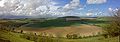
The South Downs is characterised by rolling chalk downland with close-cropped turf and dry valley
Dry valley
A dry valley is a valley found in either karst or chalk terrain that no longer has a surface flow of water.There are many examples of the latter along the North and South Downs in southern England...
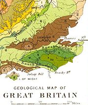
s, and is recognised as one of the most important chalk landscapes in England. It is one of the four main areas of chalk
Southern England Chalk Formation
The Chalk Formation of Southern England is a system of chalk downland in the south of England. The formation is perhaps best known for Salisbury Plain, the location of Stonehenge, the Isle of Wight and the twin ridgeways of the North Downs and South Downs....
downland
Downland
A downland is an area of open chalk hills. This term is especially used to describe the chalk countryside in southern England. Areas of downland are often referred to as Downs....
in southern England
England
England is a country that is part of the United Kingdom. It shares land borders with Scotland to the north and Wales to the west; the Irish Sea is to the north west, the Celtic Sea to the south west, with the North Sea to the east and the English Channel to the south separating it from continental...
.
The South Downs is relatively unpopulated, although in Sussex
Sussex
Sussex , from the Old English Sūþsēaxe , is an historic county in South East England corresponding roughly in area to the ancient Kingdom of Sussex. It is bounded on the north by Surrey, east by Kent, south by the English Channel, and west by Hampshire, and is divided for local government into West...
there has been large-scale urban encroachment onto the chalk downland by major seaside resorts, including most notably Brighton and Hove.
The South Downs has been inhabited since ancient times and at periods the area has supported a large population, particularly during Romano-British times. There is a rich heritage of historical features and archaeological remains, including defensive sites, burial mounds and field boundaries. Within the South Downs Environmentally Sensitive Area there are thirty-seven Sites of Special Scientific Interest, including large areas of chalk grassland.
The grazing of sheep on the thin, well-drained chalk soils of the Downs over many centuries and browsing by rabbits resulted in the fine, short, springy turf, known as old chalk grassland, that has come to epitomise the South Downs today. Until the middle of the 20th century, an agricultural system operated by downland farmers known as 'sheep-and-corn farming' underpinned this: the sheep (most famously the Southdown
Southdown (sheep)
The Southdown is a small, dual purpose British sheep but is raised primarily for meat. The Southdown breed was originally bred by John Ellman of Glynde, near Lewes, East Sussex about 200 years ago. His work was continued by Jonas Webb of Babraham in Cambridgeshire who developed the larger animal...
breed) of villagers would be systematically confined to certain corn fields to improve their fertility with their droppings and then they would be let out onto the downland to graze. However, starting in 1940 with government measures during World War II
World War II
World War II, or the Second World War , was a global conflict lasting from 1939 to 1945, involving most of the world's nations—including all of the great powers—eventually forming two opposing military alliances: the Allies and the Axis...
to increase domestic food production and continuing into the 1950s, much grassland was ploughed up for arable farming, fundamentally changing the landscape and ecology, with the loss of much biodiversity. As a result, while old chalk grassland accounted for 40-50% of the eastern Downs before the war, only 3-4% survives. This and development pressures from the surrounding population centres ultimately led to the decision to create the South Downs National Park
South Downs National Park
The South Downs National Park is England's newest National Park, having become fully operational on 1 April 2011. The park, covering an area of in southern England, stretches for from Winchester in the west to Eastbourne in the east through the counties of Hampshire, West Sussex and East Sussex...
, which came into full operation on 1 April 2011, to protect and restore the Downs.
The downland is an extremely popular recreational destination, particularly for walkers, horseriders and mountain bikers. A long distance footpath and bridleway, the South Downs Way
South Downs Way
The South Downs Way is a long distance footpath and bridleway running along the South Downs in southern England, and is one of 15 National Trails in England and Wales...
, follows the entire length of the chalk ridge from Winchester to Eastbourne, complemented by many interconnecting public footpaths and bridleways.
Toponymy
'Downs' is from Old English dün, meaning 'hill'. The word acquired the sense of 'elevated rolling grassland' around the fourteenth century. These hills are prefixed 'south' to distinguish them from another chalk escarpment, the North DownsNorth Downs
The North Downs are a ridge of chalk hills in south east England that stretch from Farnham in Surrey to the White Cliffs of Dover in Kent. The North Downs lie within two Areas of Outstanding Natural Beauty , the Surrey Hills and the Kent Downs...
, which runs roughly parallel to them about 30 miles (48 km) away on the northern edge of the Weald.
Geology
Rock (geology)
In geology, rock or stone is a naturally occurring solid aggregate of minerals and/or mineraloids.The Earth's outer solid layer, the lithosphere, is made of rock. In general rocks are of three types, namely, igneous, sedimentary, and metamorphic...
is composed of the microscopic skeletons of plankton
Plankton
Plankton are any drifting organisms that inhabit the pelagic zone of oceans, seas, or bodies of fresh water. That is, plankton are defined by their ecological niche rather than phylogenetic or taxonomic classification...
which lived in the sea, hence its colour. The chalk has many fossil
Fossil
Fossils are the preserved remains or traces of animals , plants, and other organisms from the remote past...
s, and bands of flint
Flint
Flint is a hard, sedimentary cryptocrystalline form of the mineral quartz, categorized as a variety of chert. It occurs chiefly as nodules and masses in sedimentary rocks, such as chalks and limestones. Inside the nodule, flint is usually dark grey, black, green, white, or brown in colour, and...
occur throughout the formation. The Chalk is divided into the Lower, Middle and Upper Chalk, a thin band of cream-coloured nodular chalk known as the Melbourn Rock marking the boundary between the Lower and Middle units.
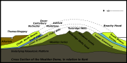
The strata of southeast England, including the Chalk, were gently folded during a phase of the Alpine Orogeny
Alpine orogeny
The Alpine orogeny is an orogenic phase in the Late Mesozoic and Tertiary that formed the mountain ranges of the Alpide belt...
to produce the Weald-Artois Anticline
Weald-Artois Anticline
The Weald–Artois anticline is a large anticline, a geological structure running between the regions of the Weald in southern England and the Artois in northeastern France. The fold formed during the Alpine orogeny, from the late Oligocene to middle Miocene as an uplifted form of the Weald basin...
, a dome-like structure with a long east-west axis. Erosion
Erosion
Erosion is when materials are removed from the surface and changed into something else. It only works by hydraulic actions and transport of solids in the natural environment, and leads to the deposition of these materials elsewhere...
has removed the central part of the dome, leaving the north-facing escarpment
Escarpment
An escarpment is a steep slope or long cliff that occurs from erosion or faulting and separates two relatively level areas of differing elevations.-Description and variants:...
of the South Downs along its southern margin with the south-facing chalk escarpment of the North Downs
North Downs
The North Downs are a ridge of chalk hills in south east England that stretch from Farnham in Surrey to the White Cliffs of Dover in Kent. The North Downs lie within two Areas of Outstanding Natural Beauty , the Surrey Hills and the Kent Downs...
as its counterpart on the northern side, as shown on the diagram. Between these two escarpments the anticline has been subject to differential erosion so that geologically distinct areas of hills and vales lie in roughly concentric circles towards the centre; these comprise the Greensand Ridge
Greensand Ridge
The Greensand Ridge is an extensive, prominent, often heavily wooded, sandstone escarpment and range of hills in south-east England. It runs in a horseshoe shape around the Weald of Surrey, Sussex and Kent. It reaches its highest elevation, , at Leith Hill in Surrey—the second highest point...
, most prominent on the north side of the Weald, where it includes Leith Hill
Leith Hill
Leith Hill to the south west of Dorking, Surrey, England, reaches above sea level, the highest point on the Greensand Ridge, and is the second highest point in south-east England, after Walbury Hill near Hungerford, West Berkshire, high....
, the highest hill in south-east England, the low-lying clay vales of the Low Weald, formed of less resistant Weald Clay
Weald Clay
Weald Clay is a Lower Cretaceous sedimentary rock underlying areas of South East England. It is part of the Wealden Group of rocks. The clay is named after the Weald, an area of Sussex. It varies from orange and grey in colour and is used in brickmaking....
, and finally the more highly resistant sandstones of the High Weald at the centre of the anticline, whose elevated forest ridge includes most notably Ashdown Forest
Ashdown Forest
Ashdown Forest is an ancient area of tranquil open heathland occupying the highest sandy ridge-top of the High Weald Area of Outstanding Natural Beauty. It is situated some south of London in the county of East Sussex, England...
.
The chalk, being porous, allows water to soak through; as a result there are many winterbournes
Winterbourne (stream)
A winterbourne is a stream or river that is dry through the summer months. A winterbourne is sometimes simply called a bourne, from the Anglo-Saxon for a stream flowing from a spring, although this term can also be used for all-year water courses....
along the northern edge.
Geography
The South Downs is a long chalk escarpmentEscarpment
An escarpment is a steep slope or long cliff that occurs from erosion or faulting and separates two relatively level areas of differing elevations.-Description and variants:...
that stretches for over 70 miles (112.7 km), rising from the valley of the River Itchen
River Itchen, Hampshire
The River Itchen is a river in Hampshire, England. It flows from mid-Hampshire to join with Southampton Water below the Itchen Bridge in the city of Southampton. The river has a total length of , and is noted as one of England's - if not one of the World's - premier chalk streams for fly fishing,...
near Winchester, Hampshire
Hampshire
Hampshire is a county on the southern coast of England in the United Kingdom. The county town of Hampshire is Winchester, a historic cathedral city that was once the capital of England. Hampshire is notable for housing the original birthplaces of the Royal Navy, British Army, and Royal Air Force...
, in the west to Beachy Head
Beachy Head
Beachy Head is a chalk headland on the south coast of England, close to the town of Eastbourne in the county of East Sussex, immediately east of the Seven Sisters. The cliff there is the highest chalk sea cliff in Britain, rising to 162 m above sea level. The peak allows views of the south...
near Eastbourne
Eastbourne
Eastbourne is a large town and borough in East Sussex, on the south coast of England between Brighton and Hastings. The town is situated at the eastern end of the chalk South Downs alongside the high cliff at Beachy Head...
, East Sussex
East Sussex
East Sussex is a county in South East England. It is bordered by the counties of Kent, Surrey and West Sussex, and to the south by the English Channel.-History:...
, in the east. Behind the steep north-facing scarp slope, the gently inclined dip slope
Dip slope
A dip slope is a geological formation often created by erosion of tilted strata. Dip slopes are found on homoclinal ridges with one side that is steep and irregular and another side, the dip slope, that is generally planar with a dip parallel to the bedding...
of undulating chalk downland extends for a distance of up to 7 miles (11.3 km) southwards. Viewed from high points further north in the High Weald and on the North Downs, the scarp of the South Downs presents itself as a steep wall that bounds the horizon, with its grassland heights punctuated with clumps of trees (such as Chanctonbury Ring
Chanctonbury Ring
Chanctonbury Ring is a hill fort based ring of trees atop Chanctonbury Hill on the South Downs, on the border of the civil parishes of Washington and Wiston in the English county of West Sussex. A ridgeway, now part of the South Downs Way, runs along the hill...
).
In the west, the chalk ridge of the South Downs merges with the North Downs
North Downs
The North Downs are a ridge of chalk hills in south east England that stretch from Farnham in Surrey to the White Cliffs of Dover in Kent. The North Downs lie within two Areas of Outstanding Natural Beauty , the Surrey Hills and the Kent Downs...
to form the Hampshire Downs. In the east, the escarpment terminates at the English Channel
English Channel
The English Channel , often referred to simply as the Channel, is an arm of the Atlantic Ocean that separates southern England from northern France, and joins the North Sea to the Atlantic. It is about long and varies in width from at its widest to in the Strait of Dover...
coast between Seaford
Seaford, East Sussex
Seaford is a coastal town in the county of East Sussex, on the south coast of England. Lying east of Newhaven and Brighton and west of Eastbourne, it is the largest town in Lewes district, with a population of about 23,000....
and Eastbourne
Eastbourne
Eastbourne is a large town and borough in East Sussex, on the south coast of England between Brighton and Hastings. The town is situated at the eastern end of the chalk South Downs alongside the high cliff at Beachy Head...
, where it produces the spectacular white cliffs of Seaford Head, the Seven Sisters
Seven Sisters, Sussex
The Seven Sisters are a series of chalk cliffs by the English Channel. They form part of the South Downs in East Sussex, between the towns of Seaford and Eastbourne in southern England. They are within the Seven Sisters Country Park...
, whose undulations reveal a cross-section through a pre-existing landscape of parallel ridges and dry valleys that has been exposed as the high chalk headland has receded through erosion by the sea, and Beachy Head
Beachy Head
Beachy Head is a chalk headland on the south coast of England, close to the town of Eastbourne in the county of East Sussex, immediately east of the Seven Sisters. The cliff there is the highest chalk sea cliff in Britain, rising to 162 m above sea level. The peak allows views of the south...
, the highest chalk sea cliff in Britain at 162 metres (531.5 ft) above sea level.
The South Downs may be said to have three main component parts: the East Hampshire Downs, the Western Downs and the Eastern Downs, together with the river valleys that cut across them and the land immediately below them, the scarpfoot. The Western and Eastern Downs are often collectively referred to as the Sussex Downs. The Western Downs, lying west of the River Arun
River Arun
The Arun is a river in the English county of West Sussex. Its source is a series of small streams in the St Leonard's Forest area, to the east of Horsham...
, are much more wooded, particularly on the scarp face, than the Eastern Downs. It is the bare Eastern Downs - the only part of the chalk escarpment to which, until the late 19th century, the term "South Downs" was usually applied - that has come to epitomise, in literature and art, the South Downs as a whole and which has been the subject matter of such celebrated writers and artists as Rudyard Kipling
Rudyard Kipling
Joseph Rudyard Kipling was an English poet, short-story writer, and novelist chiefly remembered for his celebration of British imperialism, tales and poems of British soldiers in India, and his tales for children. Kipling received the 1907 Nobel Prize for Literature...
(the "blunt, bow-headed, whale-backed downs") and Eric Ravilious
Eric Ravilious
Eric William Ravilious was an English painter, designer, book illustrator and wood engraver.-Career:Ravilious studied at Eastbourne School of Art, and at the Royal College of Art, where he studied under Paul Nash and became close friends with Edward Bawden.He began his working life as a muralist,...
.
Four river valleys cut through the South Downs, namely those of the rivers Arun, Adur
River Adur
The Adur is a river in Sussex, England; it gives its name to the Adur district of West Sussex. The river was formerly navigable for large vessels up as far as Steyning, where there was a large port, but over time the river valley became silted up and the port moved down to the deeper waters nearer...
, Ouse
River Ouse, Sussex
The River Ouse is a river in the counties of West and East Sussex in England.-Course:The river rises near Lower Beeding and runs eastwards into East Sussex, meandering narrowly and turning slowly southward...
and Cuckmere
River Cuckmere
The River Cuckmere rises near Heathfield in East Sussex, England on the southern slopes of the Weald. The name of the river probably comes from an Old English word meaning fast-flowing, since it descends over 100 m in its initial four miles...
, providing a contrasting landscape. Chalk aquifer
Aquifer
An aquifer is a wet underground layer of water-bearing permeable rock or unconsolidated materials from which groundwater can be usefully extracted using a water well. The study of water flow in aquifers and the characterization of aquifers is called hydrogeology...
s and to a lesser extent winterbourne streams
Winterbourne (stream)
A winterbourne is a stream or river that is dry through the summer months. A winterbourne is sometimes simply called a bourne, from the Anglo-Saxon for a stream flowing from a spring, although this term can also be used for all-year water courses....
supply much of the water required by the surrounding settlements. Dew pond
Dew pond
A dew pond is an artificial pond usually sited on the top of a hill, intended for watering livestock. Dew ponds are used in areas where a natural supply of surface water may not be readily available. The name dew pond is first found in the Journal of the Royal Agricultural Society in 1865...
s, artificial ponds for watering livestock, are a characteristic feature on the downland.
The highest point on the South Downs is Butser Hill
Butser Hill
Butser Hill is a chalk hill and one of the highest points in Hampshire. It is also the highest point on the chalk ridge of the South Downs and the second highest point in the South Downs National Park after Blackdown in the Western Weald. Although only high, it qualifies as one of England's...
, whose summit is 270 metres (885.8 ft) above sea level. The plateau-like top of this vast, irregularly shaped hill, which lies just south of Petersfield, Hampshire
Petersfield, Hampshire
Petersfield is a market town and civil parish in the East Hampshire district of Hampshire, England. It is north of Portsmouth, on the A3 road. The town has its own railway station on the Portsmouth Direct Line, the mainline rail link connecting Portsmouth and London. The town is situated on the...
, was in regular use through prehistory. It has been designated as a National Nature Reserve
National Nature Reserves in England
National Nature Reserves in England are managed by Natural England and are key places for wildlife and natural features in England. They were established to protect the most important areas of habitat and of geological formations...
.
Within the boundary of the South Downs National Park, which includes parts of the western Weald to the north of the South Downs, the highest point is Blackdown, West Sussex, which rises to 280 metres (919 ft) above sea level. However, Blackdown geologically is not part of the South Downs but instead forms part of the Greensand Ridge
Greensand Ridge
The Greensand Ridge is an extensive, prominent, often heavily wooded, sandstone escarpment and range of hills in south-east England. It runs in a horseshoe shape around the Weald of Surrey, Sussex and Kent. It reaches its highest elevation, , at Leith Hill in Surrey—the second highest point...
on the Weald
Weald
The Weald is the name given to an area in South East England situated between the parallel chalk escarpments of the North and the South Downs. It should be regarded as three separate parts: the sandstone "High Weald" in the centre; the clay "Low Weald" periphery; and the Greensand Ridge which...
's western margins.
A list of those points on the South Downs above 700 feet (213.4 m), going from west to east, is given below.
| Name of hill | Nearest settlement | Height | Notes |
|---|---|---|---|
| Butser Hill Butser Hill Butser Hill is a chalk hill and one of the highest points in Hampshire. It is also the highest point on the chalk ridge of the South Downs and the second highest point in the South Downs National Park after Blackdown in the Western Weald. Although only high, it qualifies as one of England's... |
Petersfield Petersfield, Hampshire Petersfield is a market town and civil parish in the East Hampshire district of Hampshire, England. It is north of Portsmouth, on the A3 road. The town has its own railway station on the Portsmouth Direct Line, the mainline rail link connecting Portsmouth and London. The town is situated on the... |
270 m (886 ft) | Highest point in the South Downs proper. |
| West Harting Down | South Harting South Harting South Harting is a village in the Chichester district of West Sussex, England. It lies within the civil parish of Harting. The village sits on the B2146 Road four miles southeast of Petersfield, Hampshire.... |
215 m (707 ft) | |
| Beacon Hill | South Harting | 242 m (793 ft) | |
| Linch Down | Bepton Bepton Bepton is a village and civil parish in the Chichester district of West Sussex, England. According to the 2001 census it had 104 households with a population of 249 of whom 117 were economically active. The village is about three miles south-west of Midhurst.-History:In 1086 Bepton was recorded... |
248 m (814 ft) | |
| Littleton Down | East Lavington East Lavington East Lavington is a village and civil parish in the District of Chichester in West Sussex, England located six kilometres south of Petworth, west of the A285 road.... |
255 m (836 ft) | The summit, Crown Teglease, is the highest point on the Sussex Downs. |
| Glatting Beacon | Sutton Sutton, West Sussex Sutton is a village and civil parish in the District of Chichester in West Sussex, England, located six kilometres south of Petworth and east of the A285 road.The parish has a land area of 920 hectares... |
245 m (803 ft) | |
| Chanctonbury Hill Chanctonbury Hill Chanctonbury Hill is a Site of Special Scientific Interest in West Sussex, England. The site is an uncommon woodland type on a chalk escarpment, making it an important area for flora and fauna, including the protected Great Crested Newt.... |
Washington Washington, West Sussex Washington is a village and civil parish in the Horsham District of West Sussex, England. It is located five miles west of Steyning and three miles east of Storrington on the A24 between Horsham and Worthing. The parish covers an area of 1,276 hectares... |
238 m (782 ft) | Site of Chanctonbury Ring Chanctonbury Ring Chanctonbury Ring is a hill fort based ring of trees atop Chanctonbury Hill on the South Downs, on the border of the civil parishes of Washington and Wiston in the English county of West Sussex. A ridgeway, now part of the South Downs Way, runs along the hill... hill fort |
| Truleigh Hill | Upper Beeding Upper Beeding Upper Beeding is a village and civil parish in the Horsham District of West Sussex, England. It is located at the northern end of the River Adur gap in the South Downs four miles north of Shoreham-by-Sea and has a land area of 1877 hectares... |
216 m (708 ft) | |
| Ditchling Beacon Ditchling Beacon Ditchling Beacon is the third-highest point on the South Downs in south-east England, behind Butser Hill and Crown Tegleaze . It consists of a large chalk hill with a particularly steep northern face, covered with open grassland and sheep-grazing areas... |
Ditchling Ditchling Ditchling is a village and civil parish in the Lewes District of East Sussex, England. The village is contained within the boundaries of the South Downs National Park; the order confirming the establishment of the park was signed in Ditchling.... |
248 m (814 ft) | |
| Firle Beacon Firle Beacon Firle Beacon is a hill in the South Downs of southern England. It is 217 metres high and is a Marilyn. It commands a far-reaching view.-References:... |
Firle Firle For the suburb of Adelaide, South Australia, see Firle, South Australia.Firle is a village and civil parish in the Lewes District of East Sussex, England. Firle refers to an old-English/Anglo-Saxon word fierol meaning overgrown with oak... |
217 m (713 ft) | |
History
Neolithic
The Neolithic Age, Era, or Period, or New Stone Age, was a period in the development of human technology, beginning about 9500 BC in some parts of the Middle East, and later in other parts of the world. It is traditionally considered as the last part of the Stone Age...
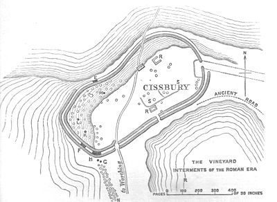
flint mines such as Cissbury
Cissbury
Cissbury is the name of a prehistoric site near the village of Findon around 5 miles north of Worthing in the English county of West Sussex. The site is managed by the National Trust....
, burial mounds such as the Devil's Jumps
Devil's Jumps, Treyford
The Devil's Jumps are a group of five large bell barrows situated on the South Downs south-east of Treyford in the county of West Sussex in southern England. The Devil's Jumps site is listed as a Scheduled Ancient Monument and as a Local Nature Reserve...
and Devil's Humps
Devil's Humps, Stoughton
The Devil's Humps are four Bronze Age barrows situated on Bow Hill on the South Downs near Stoughton, West Sussex. They are situated on a downland ridgeway crossed by an ancient trackway, above Kingley Vale. The Devil's Humps are counted among the most impressive round barrows surviving on the...
, and hill forts like Chanctonbury Ring
Chanctonbury Ring
Chanctonbury Ring is a hill fort based ring of trees atop Chanctonbury Hill on the South Downs, on the border of the civil parishes of Washington and Wiston in the English county of West Sussex. A ridgeway, now part of the South Downs Way, runs along the hill...
are strong features in the landscape.
It has been estimated that the tree cover of the downs was cleared over 3000 years ago, and the present closely grazed turf is the result of continual grazing
Grazing
Grazing generally describes a type of feeding, in which a herbivore feeds on plants , and also on other multicellular autotrophs...
by sheep.
National park
Proposals to create a national park for the South Downs date back to the 1940s. However, it was not until 1999 that the idea received firm government support. After a public enquiry that took place between 2003 and 2009, the government announced its decision to make the South Downs a national park on 31 March 2009. The South Downs National ParkSouth Downs National Park
The South Downs National Park is England's newest National Park, having become fully operational on 1 April 2011. The park, covering an area of in southern England, stretches for from Winchester in the west to Eastbourne in the east through the counties of Hampshire, West Sussex and East Sussex...
finally came into operation on 1 April 2011. Within its boundary are included not only the South Downs proper but also part of the western Weald
Western Weald
The western Weald is an area of undulating countryside in Hampshire and West Sussex containing a mixture of woodland and heathland areas.It lies to the south of the towns of Bordon, Haslemere and Rake and to the west of the town of Pulborough. It includes the towns of Liss and Petersfield on its...
, a geologically and ecologically quite different district.
The South Downs National Park has replaced two Areas of Outstanding Natural Beauty (AONB)
Area of Outstanding Natural Beauty
An Area of Outstanding Natural Beauty is an area of countryside considered to have significant landscape value in England, Wales or Northern Ireland, that has been specially designated by the Countryside Agency on behalf of the United Kingdom government; the Countryside Council for Wales on...
s: East Hampshire AONB
East Hampshire AONB
East Hampshire Area of Outstanding Natural Beauty in England was designated in 1962. The designation was revoked in March 2010, together with the neighbouring Sussex Downs AONB, upon the establishment of the South Downs National Park. The southern part of the area is mainly rolling chalk...
and Sussex Downs AONB
Sussex Downs AONB
Sussex Downs Area of Outstanding Natural Beauty in England was designated in 1966. The designation was revoked in March 2010, together with the neighbouring East Hampshire AONB, upon the establishment of the South Downs National Park ....
. During the enquiry process a number of boundary questions were considered, so that the National Park contains areas not in the former AONBs, and vice versa.
National Nature Reserves
The South Downs contains a number of National Nature ReservesNational Nature Reserves in England
National Nature Reserves in England are managed by Natural England and are key places for wildlife and natural features in England. They were established to protect the most important areas of habitat and of geological formations...
(NNRs).
The NNRs on the Sussex Downs comprise Kingley Vale, near Chichester
Chichester
Chichester is a cathedral city in West Sussex, within the historic County of Sussex, South-East England. It has a long history as a settlement; its Roman past and its subsequent importance in Anglo-Saxon times are only its beginnings...
, said by Natural England
Natural England
Natural England is the non-departmental public body of the UK government responsible for ensuring that England's natural environment, including its land, flora and fauna, freshwater and marine environments, geology and soils, are protected and improved...
to contain one of the finest yew forests in Europe, including a grove of ancient trees which are among the oldest living things in Britain (the reserve is also one of the most important archaeological sites in southern England, with 14 Scheduled Ancient Monuments); Castle Dean, between Brighton and Lewes, an important example of ancient, traditionally managed grassland; Lewes Downs (Mount Caburn
Mount Caburn
Mount Caburn is a 480-foot isolated peak, one of the highest landmarks in East Sussex, England, about one mile east of Lewes overlooking the village of Glynde. It is an isolated part of the South Downs, separated by Glynde Reach, a tributary of the River Ouse.-Enclosure:On the summit of Caburn...
), a traditionally managed chalk downland (and also an important archaeological site); and Lullington Heath
Lullington Heath
Lullington Heath is a Site of Special Scientific Interest and National Nature Reserve within the South Downs Area of Outstanding Natural Beauty, in the county of East Sussex, England. It is of interest because of its uncommon habitat of chalk grassland and chalk heath....
, on the northern fringe of Friston Forest north-west of Eastbourne, one the largest areas of chalk heath in Britain.
The NNRs on the East Hampshire Downs comprise Butser Hill
Butser Hill
Butser Hill is a chalk hill and one of the highest points in Hampshire. It is also the highest point on the chalk ridge of the South Downs and the second highest point in the South Downs National Park after Blackdown in the Western Weald. Although only high, it qualifies as one of England's...
, near Petersfield, a large area of chalk grassland on the highest point in the South Downs (a large area is also designated as a Scheduled Ancient Monument reflecting its historical significance, particularly in the Bronze and Iron Ages); Old Winchester Hill
Old Winchester Hill
Old Winchester Hill is a chalk hill in Hampshire, England surmounted by an Iron Age hill fort and a Bronze Age cemetery. It is a Site of Special Scientific Interest and a National Nature Reserve. The hill fort has never been fully excavated.-Location:...
, a lowland grassland on the west and south facing scarp slopes of the Meon valley; and Beacon Hill, a high quality chalk grassland 5km west of Old Winchester Hill.
Tourism, leisure and sport
In 1923 the Society of Sussex Downsmen (now the South Downs Society) was formed with the aim of protecting the area's unique landscape.The South Downs is a popular area for ramblers with a network of over 2000 miles (3,218.7 km) of well-managed, well-signed and easily accessible trails. The principal bridleway, and longest of them, is the South Downs Way
South Downs Way
The South Downs Way is a long distance footpath and bridleway running along the South Downs in southern England, and is one of 15 National Trails in England and Wales...
. The Monarch's Way
Monarch's Way
The Monarch's Way is a long-distance footpath in England that approximates the escape route taken by King Charles II in 1651 after being defeated in the Battle of Worcester.Most of the footpath is waymarked...
, having originated at Worcester
Worcester
The City of Worcester, commonly known as Worcester, , is a city and county town of Worcestershire in the West Midlands of England. Worcester is situated some southwest of Birmingham and north of Gloucester, and has an approximate population of 94,000 people. The River Severn runs through the...
, crosses the South Downs and ends at Shoreham-by-Sea
Shoreham-by-Sea
Shoreham-by-Sea is a small town, port and seaside resort in West Sussex, England. Shoreham-by-Sea railway station is located less than a mile from the town centre and London Gatwick Airport is away...
.
Sports undertaken on the Downs include paragliding
Paragliding
Paragliding is the recreational and competitive adventure sport of flying paragliders: lightweight, free-flying, foot-launched glider aircraft with no rigid primary structure...
, mountain-biking, horse riding and walking
Walking
Walking is one of the main gaits of locomotion among legged animals, and is typically slower than running and other gaits. Walking is defined by an 'inverted pendulum' gait in which the body vaults over the stiff limb or limbs with each step...
. The popular Beachy Head Marathon (formerly Seven Sisters Marathon), a hilly cross-country marathon, takes place each autumn on the eastern Downs, starting and finishing in Eastbourne.
Landmarks
Two of the landmarks on the Downs are the Long Man of WilmingtonLong Man of Wilmington
The Long Man of Wilmington is a hill figure located in Wilmington, East Sussex, England on the steep slopes of Windover Hill, northwest of Eastbourne. The Long Man is tall and designed to look in proportion when viewed from below....
, a chalk carved figure, and Clayton Windmills
Clayton Windmills
The Clayton Windmills, known locally as Jack and Jill, stand on the South Downs above the village of Clayton, West Sussex, England. They comprise a post mill and a tower mill, and the roundhouse of a former post mill. All three are Grade II* listed buildings....
. There is also a war memorial
War memorial
A war memorial is a building, monument, statue or other edifice to celebrate a war or victory, or to commemorate those who died or were injured in war.-Historic usage:...
, The Chattri, dedicated to Indian soldiers who died in the Brighton
Brighton
Brighton is the major part of the city of Brighton and Hove in East Sussex, England on the south coast of Great Britain...
area, having been brought there for treatment after being injured fighting on the Western Front
Western Front (World War I)
Following the outbreak of World War I in 1914, the German Army opened the Western Front by first invading Luxembourg and Belgium, then gaining military control of important industrial regions in France. The tide of the advance was dramatically turned with the Battle of the Marne...
in the First World War.
South Downs in literature
Rudyard KiplingRudyard Kipling
Joseph Rudyard Kipling was an English poet, short-story writer, and novelist chiefly remembered for his celebration of British imperialism, tales and poems of British soldiers in India, and his tales for children. Kipling received the 1907 Nobel Prize for Literature...
who lived at Rottingdean
Rottingdean
Rottingdean is a coastal village next to the town of Brighton and technically within the city of Brighton and Hove, in East Sussex, on the south coast of England...
described the South Downs as "Our blunt, bow-headed whale-backed Downs". Writing in 1920 in his poem The South Country, poet Hilaire Belloc
Hilaire Belloc
Joseph Hilaire Pierre René Belloc was an Anglo-French writer and historian who became a naturalised British subject in 1902. He was one of the most prolific writers in England during the early twentieth century. He was known as a writer, orator, poet, satirist, man of letters and political activist...
describes the South Downs as "the great hills of the South Country". In On The South Coast, poet Algernon Charles Swinburne
Algernon Charles Swinburne
Algernon Charles Swinburne was an English poet, playwright, novelist, and critic. He invented the roundel form, wrote several novels, and contributed to the famous Eleventh Edition of the Encyclopaedia Britannica...
describes the South Downs as "the green smooth-swelling unending downs".
The naturalist-writer William Henry Hudson
William Henry Hudson
William Henry Hudson was an author, naturalist, and ornithologist.- Life and work :Hudson was born in the Quilmes, a borough of the greater Buenos Aires, in Buenos Aires Province, Argentina, son of settlers of U.S. origin...
wrote that "during the whole fifty-three mile length from Beachy Head to Harting the ground never rises above a height of 850 feet, but we feel on top of the world".
Poet Francis William Bourdillon
Francis William Bourdillon
Francis William Bourdillon was a British poet and translator.-Life:Born in Runcorn, Cheshire, Bourdillon was educated at Worcester College, Oxford. He acted as tutor to the sons of Prince Christian of Schleswig-Holstein...
also wrote a poem "On the South Downs". The South Downs have been home to several writers including Jane Austen
Jane Austen
Jane Austen was an English novelist whose works of romantic fiction, set among the landed gentry, earned her a place as one of the most widely read writers in English literature, her realism and biting social commentary cementing her historical importance among scholars and critics.Austen lived...
who lived at Chawton
Chawton
Chawton is a village and civil parish in the East Hampshire district of Hampshire, England. It is 1.6 miles southwest of Alton, just south of the A31 which runs between Farnham and Winchester. The village is famous as the home of Jane Austen for the last eight years of her life...
on the edge of the Downs in Hampshire. The Bloomsbury Group
Bloomsbury Group
The Bloomsbury Group or Bloomsbury Set was a group of writers, intellectuals, philosophers and artists who held informal discussions in Bloomsbury throughout the 20th century. This English collective of friends and relatives lived, worked or studied near Bloomsbury in London during the first half...
often visited Monk's House
Monk's House
Monk's House is an 18th century weatherboarded cottage located in the village of Rodmell, three miles south-east of Lewes, East Sussex, England. The writer Virginia Woolf and her husband, the political activist, journalist and editor Leonard Woolf, purchased the house in 1919, and received many...
in Rodmell
Rodmell
Rodmell is a small village and civil parish in the Lewes District of East Sussex, England. It is located three miles south-west of Lewes, on the Lewes to Newhaven road and is situated by the west banks of the River Ouse...
, the home of Virginia Woolf
Virginia Woolf
Adeline Virginia Woolf was an English author, essayist, publisher, and writer of short stories, regarded as one of the foremost modernist literary figures of the twentieth century....
in the Ouse valley. Alfred, Lord Tennyson had a second home at Aldworth, on Blackdown
Blackdown, Sussex
Blackdown, or Black Down, is the highest hill in the historic county of Sussex, at 280 metres , and is second only to Leith Hill in southeastern England....
; geologically part of the Weald
Weald
The Weald is the name given to an area in South East England situated between the parallel chalk escarpments of the North and the South Downs. It should be regarded as three separate parts: the sandstone "High Weald" in the centre; the clay "Low Weald" periphery; and the Greensand Ridge which...
, Blackdown lies north of the South Downs but is included in the South Downs National Park.