

White Peak
Encyclopedia
Peak District
The Peak District is an upland area in central and northern England, lying mainly in northern Derbyshire, but also covering parts of Cheshire, Greater Manchester, Staffordshire, and South and West Yorkshire....
in England
England
England is a country that is part of the United Kingdom. It shares land borders with Scotland to the north and Wales to the west; the Irish Sea is to the north west, the Celtic Sea to the south west, with the North Sea to the east and the English Channel to the south separating it from continental...
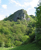
. In contrast to the Dark Peak
Dark Peak
The Dark Peak is the higher, wilder northern part of the Peak District in England.It gets its name because , the underlying limestone is covered by a cap of Millstone Grit which means that in winter the soil is almost always saturated with water...
, the underlying limestone
Limestone
Limestone is a sedimentary rock composed largely of the minerals calcite and aragonite, which are different crystal forms of calcium carbonate . Many limestones are composed from skeletal fragments of marine organisms such as coral or foraminifera....
is not capped by impervious millstone grit, so cave
Cave
A cave or cavern is a natural underground space large enough for a human to enter. The term applies to natural cavities some part of which is in total darkness. The word cave also includes smaller spaces like rock shelters, sea caves, and grottos.Speleology is the science of exploration and study...
s and dry river valleys are common features of the area. The soils are poor and calcareous, creating grazing land for both sheep and cattle.
Broadly speaking, the White Peak covers the Staffordshire
Staffordshire
Staffordshire is a landlocked county in the West Midlands region of England. For Eurostat purposes, the county is a NUTS 3 region and is one of four counties or unitary districts that comprise the "Shropshire and Staffordshire" NUTS 2 region. Part of the National Forest lies within its borders...
Peaks, the Cheshire
Cheshire
Cheshire is a ceremonial county in North West England. Cheshire's county town is the city of Chester, although its largest town is Warrington. Other major towns include Widnes, Congleton, Crewe, Ellesmere Port, Runcorn, Macclesfield, Winsford, Northwich, and Wilmslow...
Peaks around Macclesfield
Macclesfield
Macclesfield is a market town within the unitary authority of Cheshire East, the county palatine of Chester, also known as the ceremonial county of Cheshire, England. The population of the Macclesfield urban sub-area at the time of the 2001 census was 50,688...
and the Derbyshire
Derbyshire
Derbyshire is a county in the East Midlands of England. A substantial portion of the Peak District National Park lies within Derbyshire. The northern part of Derbyshire overlaps with the Pennines, a famous chain of hills and mountains. The county contains within its boundary of approx...
Peaks from the Hope Valley
Hope Valley, Derbyshire
The Hope Valley is a rural area centred on the village of Hope, Derbyshire in the Peak District in the northern Midlands of England.The name also applies to the Post Town which includes the surrounding villages.-The Valley:...
southwards.
The largest towns in the White Peak are outside the area of the Peak District national park
National park
A national park is a reserve of natural, semi-natural, or developed land that a sovereign state declares or owns. Although individual nations designate their own national parks differently A national park is a reserve of natural, semi-natural, or developed land that a sovereign state declares or...
. These towns include Matlock and Buxton
Buxton
Buxton is a spa town in Derbyshire, England. It has the highest elevation of any market town in England. Located close to the county boundary with Cheshire to the west and Staffordshire to the south, Buxton is described as "the gateway to the Peak District National Park"...
, while Bakewell
Bakewell
Bakewell is a small market town in the Derbyshire Dales district of Derbyshire, England, deriving its name from 'Beadeca's Well'. It is the only town included in the Peak District National Park, and is well known for the local confection Bakewell Pudding...
and most of the villages in the park are in the White Peak area. Round the areas of Tideswell
Tideswell
Tideswell is a village and civil parish in the Peak District of Derbyshire, in England. It lies east of Buxton on the B6049, in a wide dry valley on a limestone plateau, at an altitude of above sea level, and is within the District of Derbyshire Dales...
, Flagg
Flagg
Flagg is a small Peak District village, set in the Derbyshire Dales, halfway between the small market town of Bakewell and the spa town of Buxton, in the area officially known as "The White Peak"...
, Chelmorton
Chelmorton
Chelmorton is a village situated in the Peak National Park, the Derbyshire Dales and the White Peak. The village is often described as linear with medieval strip fields radiating horizontally from a main street, rising up a gradual hill....
and Youlgrave, you can see long thin fields created by the enclosure of medieval strip fields. The region is rich in footpaths, bridleways and green tracks that give access to the area. Longer distance ones include the Limestone Way
Limestone Way
The Limestone Way is a long-distance bridleway in Derbyshire, England. It runs through the White Peak of the Peak District National Park, from Castleton south east to Rocester over the county boundary in Staffordshire. It originally ran to Matlock, but was diverted to its current, longer route to...
and the Pennine Bridleway
Pennine Bridleway
The Pennine Bridleway is a new National Trail under designation in Northern England.It runs roughly parallel with the Pennine Way but provides access for horseback riders and cyclists as well as walkers. The trail is around long; through Derbyshire to the South Pennines, the Mary Towneley Loop...
, and former railway trackbeds such as the Monsal Trail
Monsal Trail
The Monsal Trail is a cycle, horse riding and walking trail in the Derbyshire Peak District.-Route description:It follows a section of the former Manchester, Buxton, Matlock and Midlands Junction Railway, built by the Midland Railway in 1863 to link Manchester with London...
, the High Peak Trail, the Tissington Trail
Tissington Trail
right|thumb|200px|The Trail at the site of the former Tissington station, now a picnic site.The Tissington Trail is a bridleway and walk/cycle path in Derbyshire, England...
and the Manifold Way.
The area is of interest to geologists, since much of the underlying strata have been exposed by extensive quarrying, and can be seen in the old railway cuttings along the Monsal Trail through Monsal Dale
Monsal Dale
Monsal Dale is a valley in the Peak District of Derbyshire in England.In geological history this area of Derbyshire was long ago under water, and is formed from a subsequent uplift of resultant sedimentary deposits, known as the Derbyshire Dome...
and Millers Dale
Millers Dale
Millers Dale is a valley on the River Wye in Derbyshire.It is a popular beauty spot in the Peak District of England, much of the area being preserved as a Site of Special Scientific Interest. Nearby is Ravenstor and Cheedale, both popular with rock-climbers...
.
External links
- More information about the White Peak.