
Old Red Sandstone
Encyclopedia
Rock formation
This is a list of rock formations that include isolated, scenic, or spectacular surface rock outcrops. These formations are usually the result of weathering and erosion sculpting the existing rock...
of considerable importance to early paleontology
Paleontology
Paleontology "old, ancient", ὄν, ὀντ- "being, creature", and λόγος "speech, thought") is the study of prehistoric life. It includes the study of fossils to determine organisms' evolution and interactions with each other and their environments...
. For convenience the short version of the term, 'ORS' is often used in literature on the subject.
Sedimentology
Devonian
The Devonian is a geologic period and system of the Paleozoic Era spanning from the end of the Silurian Period, about 416.0 ± 2.8 Mya , to the beginning of the Carboniferous Period, about 359.2 ± 2.5 Mya...
but extending back into the late Silurian
Silurian
The Silurian is a geologic period and system that extends from the end of the Ordovician Period, about 443.7 ± 1.5 Mya , to the beginning of the Devonian Period, about 416.0 ± 2.8 Mya . As with other geologic periods, the rock beds that define the period's start and end are well identified, but the...
and on into the earliest part of the Carboniferous
Carboniferous
The Carboniferous is a geologic period and system that extends from the end of the Devonian Period, about 359.2 ± 2.5 Mya , to the beginning of the Permian Period, about 299.0 ± 0.8 Mya . The name is derived from the Latin word for coal, carbo. Carboniferous means "coal-bearing"...
. The body of rock
Rock (geology)
In geology, rock or stone is a naturally occurring solid aggregate of minerals and/or mineraloids.The Earth's outer solid layer, the lithosphere, is made of rock. In general rocks are of three types, namely, igneous, sedimentary, and metamorphic...
, or facies
Facies
In geology, facies are a body of rock with specified characteristics. Ideally, a facies is a distinctive rock unit that forms under certain conditions of sedimentation, reflecting a particular process or environment....
, is dominated by alluvial sediment
Sediment
Sediment is naturally occurring material that is broken down by processes of weathering and erosion, and is subsequently transported by the action of fluids such as wind, water, or ice, and/or by the force of gravity acting on the particle itself....
s and conglomerates
Conglomerate (geology)
A conglomerate is a rock consisting of individual clasts within a finer-grained matrix that have become cemented together. Conglomerates are sedimentary rocks consisting of rounded fragments and are thus differentiated from breccias, which consist of angular clasts...
at its base, and progresses to a combination of dune
Dune
In physical geography, a dune is a hill of sand built by wind. Dunes occur in different forms and sizes, formed by interaction with the wind. Most kinds of dunes are longer on the windward side where the sand is pushed up the dune and have a shorter "slip face" in the lee of the wind...
s, lake
Lake
A lake is a body of relatively still fresh or salt water of considerable size, localized in a basin, that is surrounded by land. Lakes are inland and not part of the ocean and therefore are distinct from lagoons, and are larger and deeper than ponds. Lakes can be contrasted with rivers or streams,...
s and river
River
A river is a natural watercourse, usually freshwater, flowing towards an ocean, a lake, a sea, or another river. In a few cases, a river simply flows into the ground or dries up completely before reaching another body of water. Small rivers may also be called by several other names, including...
sediments.
The familiar red colour of these rocks arises from the presence of iron oxide
Iron oxide
Iron oxides are chemical compounds composed of iron and oxygen. All together, there are sixteen known iron oxides and oxyhydroxides.Iron oxides and oxide-hydroxides are widespread in nature, play an important role in many geological and biological processes, and are widely utilized by humans, e.g.,...
but not all the Old Red Sandstone is red or sandstone — the sequence also includes conglomerates
Conglomerate (geology)
A conglomerate is a rock consisting of individual clasts within a finer-grained matrix that have become cemented together. Conglomerates are sedimentary rocks consisting of rounded fragments and are thus differentiated from breccias, which consist of angular clasts...
, mudstones, siltstones and thin limestones and colours can range from grey and green through red to purple. These deposits are closely associated with the erosion of the Caledonian Mountain chain which was thrown up by the collision of the former continents of Avalonia
Avalonia
Avalonia was a microcontinent in the Paleozoic era. Crustal fragments of this former microcontinent underlie south-west Great Britain, and the eastern coast of North America. It is the source of many of the older rocks of Western Europe, Atlantic Canada, and parts of the coastal United States...
, Baltica
Baltica
Baltica is a name applied by geologists to a late-Proterozoic, early-Palaeozoic continent that now includes the East European craton of northwestern Eurasia. Baltica was created as an entity not earlier than 1.8 billion years ago. Before this time, the three segments/continents that now comprise...
and Laurentia
Laurentia
Laurentia is a large area of continental craton, which forms the ancient geological core of the North American continent...
to form the Old Red Sandstone Continent- an event known as the Caledonian Orogeny
Caledonian orogeny
The Caledonian orogeny is a mountain building era recorded in the northern parts of the British Isles, the Scandinavian Mountains, Svalbard, eastern Greenland and parts of north-central Europe. The Caledonian orogeny encompasses events that occurred from the Ordovician to Early Devonian, roughly...
.
Many fossils are found within the rocks, including early fishes, arthropods and plants. The rocks may appear paleontologically barren to amateur geologists but careful study, particularly with an accomplished fossil hunter, can uncover pockets of fossils. Rocks of this age were also laid down in south-west England (hence the name 'Devonian') though these are of true marine origin and are not included within the Old Red Sandstone.
Stratigraphy
Since the Old Red Sandstone consists predominantly of rocks of terrestrial origin, it does not generally contain marine fossilFossil
Fossils are the preserved remains or traces of animals , plants, and other organisms from the remote past...
s which would otherwise prove useful in correlating one occurrence of the rock with another, both between and within individual sedimentary basin
Sedimentary basin
The term sedimentary basin is used to refer to any geographical feature exhibiting subsidence and consequent infilling by sedimentation. As the sediments are buried, they are subjected to increasing pressure and begin the process of lithification...
s. Accordingly local stage names were devised and these remain in use to some extent today though there is an increasing use of international stage names. Thus in the Anglo-Welsh Basin, there are frequent references to the Downtonian, Dittonian, Breconian and Farlovian stages in the literature. The existence of a number of distinct sedimentary basins throughout Britain has been established.
The Orcadian Basin
The Orcadian Basin extends over a wide area of North East Scotland and the neighbouring seas. It encompasses the Moray FirthMoray Firth
The Moray Firth is a roughly triangular inlet of the North Sea, north and east of Inverness, which is in the Highland council area of north of Scotland...
and adjoining land areas, Caithness, Orkney and parts of Shetland. South of the Moray Firth, two distinct sub-basins are recognised at Turriff
Turriff
Turriff is a town and civil parish in Aberdeenshire in Scotland. It is approximately above sea level, and has a population of 5,708.Turriff is known locally as Turra in the Doric dialect of Scots...
and at Rhynie. The sequence is more than 4 km thick in parts of Shetland. The main basin is considered to be an intramontane basin resulting from crustal rifting associated with post-Caledonian extension
Extensional tectonics
Extensional tectonics is concerned with the structures formed, and the tectonic processes associated with, the stretching of the crust or lithosphere.-Deformation styles:...
, possibly accompanied by strike-slip faulting along the Great Glen Fault
Great Glen Fault
The Great Glen Fault is a long strike-slip fault that runs through its namesake the Great Glen in Scotland. However, the fault is actually much longer and over 400 million years old.-Location:...
system.
The Midland Valley of Scotland
The Midland ValleyCentral Lowlands
The Central Lowlands or Midland Valley is a geologically defined area of relatively low-lying land in southern Scotland. It consists of a rift valley between the Highland Boundary Fault to the north and the Southern Uplands Fault to the south...
graben
Graben
In geology, a graben is a depressed block of land bordered by parallel faults. Graben is German for ditch. Graben is used for both the singular and plural....
defined by the Highland Boundary Fault
Highland Boundary Fault
The Highland Boundary Fault is a geological fault that traverses Scotland from Arran and Helensburgh on the west coast to Stonehaven in the east...
in the north and the Southern Uplands Fault
Southern Uplands Fault
The Southern Uplands Fault is a fault in Scotland that runs from Girvan to Dunbar on the East coast. It marks the southern boundary of the Scottish Midland Valley....
in the south harbours not only a considerable amount of Old Red Sandstone sedimentary rocks but also igneous rocks of this age assciated with extensive volcanism
Volcanism
Volcanism is the phenomenon connected with volcanoes and volcanic activity. It includes all phenomena resulting from and causing magma within the crust or mantle of a planet to rise through the crust and form volcanic rocks on the surface....
. There is a continuous outcrop along the Highland Boundary Fault from Stonehaven
Stonehaven
Stonehaven is a town in Aberdeenshire, Scotland. It lies on Scotland's northeast coast and had a population of 9,577 in 2001 census.Stonehaven, county town of Kincardineshire, grew around an Iron Age fishing village, now the "Auld Toon" , and expanded inland from the seaside...
on the North Sea
North Sea
In the southwest, beyond the Straits of Dover, the North Sea becomes the English Channel connecting to the Atlantic Ocean. In the east, it connects to the Baltic Sea via the Skagerrak and Kattegat, narrow straits that separate Denmark from Norway and Sweden respectively...
coast to Helensburgh
Helensburgh
Helensburgh is a town in Argyll and Bute, Scotland. It lies on the north shore of the Firth of Clyde and the eastern shore of the entrance to the Gareloch....
and beyond to Arran
Isle of Arran
Arran or the Isle of Arran is the largest island in the Firth of Clyde, Scotland, and with an area of is the seventh largest Scottish island. It is in the unitary council area of North Ayrshire and the 2001 census had a resident population of 5,058...
. A more disconnected series of outcrops occur along the line of the Southern Uplands Fault from Edinburgh
Edinburgh
Edinburgh is the capital city of Scotland, the second largest city in Scotland, and the eighth most populous in the United Kingdom. The City of Edinburgh Council governs one of Scotland's 32 local government council areas. The council area includes urban Edinburgh and a rural area...
to Girvan
Girvan
Girvan is a burgh in Carrick, South Ayrshire, Scotland, with a population of about 8000 people. Originally a fishing port, it is now also a seaside resort with beaches and cliffs. Girvan dates back to 1668 when is became a municipal burgh incorporated by by charter...
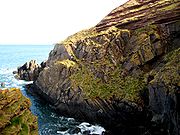
. Old Red Sandstone often occurs in conjunction with conglomerate formations, one such noteworthy cliff
Cliff
In geography and geology, a cliff is a significant vertical, or near vertical, rock exposure. Cliffs are formed as erosion landforms due to the processes of erosion and weathering that produce them. Cliffs are common on coasts, in mountainous areas, escarpments and along rivers. Cliffs are usually...
side exposure being the Fowlsheugh Nature Reserve, Kincardineshire
Kincardineshire
The County of Kincardine, also known as Kincardineshire or The Mearns was a local government county on the coast of northeast Scotland...
.
The Scottish Borders
A series of outcrops occur from East LothianEast Lothian
East Lothian is one of the 32 council areas of Scotland, and a lieutenancy Area. It borders the City of Edinburgh, Scottish Borders and Midlothian. Its administrative centre is Haddington, although its largest town is Musselburgh....
southwards through Berwickshire
Berwickshire
Berwickshire or the County of Berwick is a registration county, a committee area of the Scottish Borders Council, and a lieutenancy area of Scotland, on the border with England. The town after which it is named—Berwick-upon-Tweed—was lost by Scotland to England in 1482...
. Hutton's famous unconformity at Siccar Point occurs within this basin - see History of study below.
The Anglo-Welsh Basin
This relatively large basin extends across much of South WalesWales
Wales is a country that is part of the United Kingdom and the island of Great Britain, bordered by England to its east and the Atlantic Ocean and Irish Sea to its west. It has a population of three million, and a total area of 20,779 km²...
from southern Pembrokeshire
Pembrokeshire
Pembrokeshire is a county in the south west of Wales. It borders Carmarthenshire to the east and Ceredigion to the north east. The county town is Haverfordwest where Pembrokeshire County Council is headquartered....
in the west through Carmarthenshire
Carmarthenshire
Carmarthenshire is a unitary authority in the south west of Wales and one of thirteen historic counties. It is the 3rd largest in Wales. Its three largest towns are Llanelli, Carmarthen and Ammanford...
into Powys
Powys
Powys is a local-government county and preserved county in Wales.-Geography:Powys covers the historic counties of Montgomeryshire and Radnorshire, most of Brecknockshire , and a small part of Denbighshire — an area of 5,179 km², making it the largest county in Wales by land area.It is...
and Monmouthshire
Monmouthshire
Monmouthshire is a county in south east Wales. The name derives from the historic county of Monmouthshire which covered a much larger area. The largest town is Abergavenny. There are many castles in Monmouthshire .-Historic county:...
and through the southern Welsh Marches
Welsh Marches
The Welsh Marches is a term which, in modern usage, denotes an imprecisely defined area along and around the border between England and Wales in the United Kingdom. The precise meaning of the term has varied at different periods...
, notably into Herefordshire
Herefordshire
Herefordshire is a historic and ceremonial county in the West Midlands region of England. For Eurostat purposes it is a NUTS 3 region and is one of three counties that comprise the "Herefordshire, Worcestershire and Gloucestershire" NUTS 2 region. It also forms a unitary district known as the...
, Worcestershire
Worcestershire
Worcestershire is a non-metropolitan county, established in antiquity, located in the West Midlands region of England. For Eurostat purposes it is a NUTS 3 region and is one of three counties that comprise the "Herefordshire, Worcestershire and Warwickshire" NUTS 2 region...
and Gloucestershire
Gloucestershire
Gloucestershire is a county in South West England. The county comprises part of the Cotswold Hills, part of the flat fertile valley of the River Severn, and the entire Forest of Dean....
. Outliers in Somerset
Somerset
The ceremonial and non-metropolitan county of Somerset in South West England borders Bristol and Gloucestershire to the north, Wiltshire to the east, Dorset to the south-east, and Devon to the south-west. It is partly bounded to the north and west by the Bristol Channel and the estuary of the...
and north Devon
Devon
Devon is a large county in southwestern England. The county is sometimes referred to as Devonshire, although the term is rarely used inside the county itself as the county has never been officially "shired", it often indicates a traditional or historical context.The county shares borders with...
complete the extent of this basin.
With the exception of south Pembrokeshire, all parts of the basin are represented by a range of lithologies assigned to the Lower Devonian and to the Upper Devonian, the contact between the two being unconformable and representing the complete omission of any Middle Devonian sequence. The lowermost formations are of upper Silurian age, these being the Downton Castle Sandstone Formation and the overlying Raglan Mudstone Formation except in Pembrokeshire where a more complex series of formations is recognised. In the east of the basin, the top of the Raglan Mudstone is marked by a well-developed calcrete, the Bishop's Frome Limestone
Bishop's Frome Limestone
The Bishop's Frome Limestone is a rock unit within the Raglan Mudstone Formation of the Old Red Sandstone occurring in the border region between England and South Wales. This limestone is a calcrete, that is to say it originated as a soil during a break in deposition rather than than being an...
. The lowermost Devonian formation is the St Maughans Formation, itself overlain by the Brownstones Formation though with an intervening Senni Formation over much of the area. The Upper Devonian sequence is rather thinner and comprises a series of formations which are more laterally restricted. In the Brecon Beacons, the Plateau Beds Formation is unconformably overlain by the Grey Grits Formation though further east these divisions are replaced by the Quartz Conglomerate Group which is itself subdivided into a variety of different formations.
Anglesey
A small and separate basin where both alluvial and lacustrineLake
A lake is a body of relatively still fresh or salt water of considerable size, localized in a basin, that is surrounded by land. Lakes are inland and not part of the ocean and therefore are distinct from lagoons, and are larger and deeper than ponds. Lakes can be contrasted with rivers or streams,...
deposits are recorded. Calcretes are also recorded representing carbonate-rich soils developed between periods of sediment deposition. The present day outcrop occupies a narrow zone from Dulas Bay
Dulas Bay
Dulas Bay is a small bay on the north east coast of Anglesey , north Wales. The bay is bordered by three beaches.- Overview :...
on Anglesey's northeast coast, southwards to the town of Llangefni
Llangefni
Llangefni is the county town of Anglesey in Wales and contains the principal offices of the Isle of Anglesey County Council. According to the United Kingdom Census 2001, the population of Llangefni was 4,662 people and it is the second largest settlement on the island...
.
History of study
In 1787 James HuttonJames Hutton
James Hutton was a Scottish physician, geologist, naturalist, chemical manufacturer and experimental agriculturalist. He is considered the father of modern geology...
noted what is now known as Hutton's Unconformity
Hutton's Unconformity
Hutton's Unconformity is any of various famous geological sites in Scotland. These are places identified by 18th-century Scottish geologist James Hutton as an unconformity, which provided evidence for his Plutonist theories of uniformitarianism and about the age of the Earth.-Theory of rock...
at Inchbonny, Jedburgh
Jedburgh
Jedburgh is a town and former royal burgh in the Scottish Borders and historically in Roxburghshire.-Location:Jedburgh lies on the Jed Water, a tributary of the River Teviot, it is only ten miles from the border with England and is dominated by the substantial ruins of Jedburgh Abbey...
, and in the Spring of 1788 he set off with John Playfair
John Playfair
John Playfair FRSE, FRS was a Scottish scientist and mathematician, and a professor of natural philosophy at the University of Edinburgh. He is perhaps best known for his book Illustrations of the Huttonian Theory of the Earth , which summarized the work of James Hutton...
to the Berwickshire
Berwickshire
Berwickshire or the County of Berwick is a registration county, a committee area of the Scottish Borders Council, and a lieutenancy area of Scotland, on the border with England. The town after which it is named—Berwick-upon-Tweed—was lost by Scotland to England in 1482...
coast and found more examples of this sequence in the valleys of the Tour and Pease Burns near Cockburnspath
Cockburnspath
Cockburnspath is a village in the Scottish Borders area of Scotland. It lies near the North Sea coast between Berwick-upon-Tweed and Edinburgh. It is at the eastern extremity of the Southern Upland Way, a long-distance footpath from the west to east coast of Scotland, and it is also the terminus...
. They then took a boat trip from Dunglass Burn east along the coast with the geologist Sir James Hall of Dunglass
Dunglass
Dunglass is a location in East Lothian, Scotland, lying east of the Lammermuir Hills on the North Sea coast. It has a 15th century Dunglass Collegiate Church, now in the care of Historic Scotland...
and at Siccar Point
Siccar Point
Siccar Point is a rocky promontory in the county of Berwickshire on the east coast of Scotland.It is famous in the history of geology for Hutton's Unconformity found in 1788, which James Hutton regarded as conclusive proof of his uniformitarian theory of geological development.-History:Siccar...
found what Hutton called "a beautiful picture of this junction washed bare by the sea", where 345 million year old Devonian
Devonian
The Devonian is a geologic period and system of the Paleozoic Era spanning from the end of the Silurian Period, about 416.0 ± 2.8 Mya , to the beginning of the Carboniferous Period, about 359.2 ± 2.5 Mya...
Old Red Sandstone overlies 425 million year old Silurian
Silurian
The Silurian is a geologic period and system that extends from the end of the Ordovician Period, about 443.7 ± 1.5 Mya , to the beginning of the Devonian Period, about 416.0 ± 2.8 Mya . As with other geologic periods, the rock beds that define the period's start and end are well identified, but the...
greywacke
Greywacke
Greywacke or Graywacke is a variety of sandstone generally characterized by its hardness, dark color, and poorly sorted angular grains of quartz, feldspar, and small rock fragments or lithic fragments set in a compact, clay-fine matrix. It is a texturally immature sedimentary rock generally found...
.
In the early 19th century, the paleontology of the formation was studied intensively by Hugh Miller
Hugh Miller
Hugh Miller was a self-taught Scottish geologist and writer, folklorist and an evangelical Christian.- Life and work :Born in Cromarty, he was educated in a parish school where he reportedly showed a love of reading. At 17 he was apprenticed to a stonemason, and his work in quarries, together with...
, Henry Thomas De la Beche
Henry De la Beche
Sir Henry Thomas De la Beche FRS was an English geologist and palaeontologist who helped pioneer early geological survey methods.-Biography:...
, Roderick Murchison
Roderick Murchison
Sir Roderick Impey Murchison, 1st Baronet KCB DCL FRS FRSE FLS PRGS PBA MRIA was a Scottish geologist who first described and investigated the Silurian system.-Early life and work:...
, and Adam Sedgwick
Adam Sedgwick
Adam Sedgwick was one of the founders of modern geology. He proposed the Devonian period of the geological timescale...
-- Sedgwick's interpretation was the one that placed it in the Devonian
Devonian
The Devonian is a geologic period and system of the Paleozoic Era spanning from the end of the Silurian Period, about 416.0 ± 2.8 Mya , to the beginning of the Carboniferous Period, about 359.2 ± 2.5 Mya...
: in fact it was he who coined the name of that period. The term 'Old Red Sandstone' was originally used in 1821 by Scottish naturalist
Naturalist
Naturalist may refer to:* Practitioner of natural history* Conservationist* Advocate of naturalism * Naturalist , autobiography-See also:* The American Naturalist, periodical* Naturalism...
and mineralogist Robert Jameson
Robert Jameson
thumb|Robert JamesonProfessor Robert Jameson, FRS FRSE was a Scottish naturalist and mineralogist.As Regius Professor at the University of Edinburgh for fifty years, Jameson is notable for his advanced scholarship in natural history, his superb museum collection, and for his tuition of Charles...
to refer to the red rocks which underlay the 'Mountain Limestone' i.e. the Carboniferous Limestone. They were thought at that time to be the British version of Germany's Rotliegendes, which is in fact of Permian
Permian
The PermianThe term "Permian" was introduced into geology in 1841 by Sir Sir R. I. Murchison, president of the Geological Society of London, who identified typical strata in extensive Russian explorations undertaken with Edouard de Verneuil; Murchison asserted in 1841 that he named his "Permian...
age. Many of the science
Science
Science is a systematic enterprise that builds and organizes knowledge in the form of testable explanations and predictions about the universe...
of stratigraphy
Stratigraphy
Stratigraphy, a branch of geology, studies rock layers and layering . It is primarily used in the study of sedimentary and layered volcanic rocks....
's early debates were about the Old Red Sandstone.
Note that in older geological works predating theories of plate tectonics
Plate tectonics
Plate tectonics is a scientific theory that describes the large scale motions of Earth's lithosphere...
, the United States
United States
The United States of America is a federal constitutional republic comprising fifty states and a federal district...
' Catskill Delta
Catskill Delta
The Devonian Catskill Formation or the Catskill clastic wedge is a unit of mostly terrestrial sedimentary rock found in Pennsylvania and New York. Minor marine layers exist in this thick rock unit...
formation is sometimes referred to as part of the Old Red Sandstone. In the modern day, however, it is recognized that the two are not stratigraphically continuous but are very similar due to being formed at approximately the same time by the same processes.
Use as a Building Stone
Stonehaven
Stonehaven is a town in Aberdeenshire, Scotland. It lies on Scotland's northeast coast and had a population of 9,577 in 2001 census.Stonehaven, county town of Kincardineshire, grew around an Iron Age fishing village, now the "Auld Toon" , and expanded inland from the seaside...
http://www.geograph.org.uk/photo/257397, Perth
Perth, Scotland
Perth is a town and former city and royal burgh in central Scotland. Located on the banks of the River Tay, it is the administrative centre of Perth and Kinross council area and the historic county town of Perthshire...
http://www.geograph.org.uk/photo/12129, and Tayside
Tayside
Tayside Region was a local government region of Scotland from 15 May 1975 to 31 March 1996. It was created by the 1973 Act following recommendations made by the 1969 Wheatley Report which attempted to replace the mishmash of counties, cities, burghs and districts, with a uniform two-tier system...
. The inhabitants of Caithness
Caithness
Caithness is a registration county, lieutenancy area and historic local government area of Scotland. The name was used also for the earldom of Caithness and the Caithness constituency of the Parliament of the United Kingdom . Boundaries are not identical in all contexts, but the Caithness area is...
http://www.geograph.org.uk/photo/1064 at the northeastern tip of Scotland also used the stone to a considerable extent. Old Red Sandstone has also frequently been used in buildings in Herefordshire
Herefordshire
Herefordshire is a historic and ceremonial county in the West Midlands region of England. For Eurostat purposes it is a NUTS 3 region and is one of three counties that comprise the "Herefordshire, Worcestershire and Gloucestershire" NUTS 2 region. It also forms a unitary district known as the...
, Monmouthshire
Monmouthshire
Monmouthshire is a county in south east Wales. The name derives from the historic county of Monmouthshire which covered a much larger area. The largest town is Abergavenny. There are many castles in Monmouthshire .-Historic county:...
and the former Brecknockshire
Brecknockshire
Brecknockshire , also known as the County of Brecknock, Breconshire, or the County of Brecon is one of thirteen historic counties of Wales, and a former administrative county.-Geography:...
(now south Powys
Powys
Powys is a local-government county and preserved county in Wales.-Geography:Powys covers the historic counties of Montgomeryshire and Radnorshire, most of Brecknockshire , and a small part of Denbighshire — an area of 5,179 km², making it the largest county in Wales by land area.It is...
) of south Wales
Wales
Wales is a country that is part of the United Kingdom and the island of Great Britain, bordered by England to its east and the Atlantic Ocean and Irish Sea to its west. It has a population of three million, and a total area of 20,779 km²...
.
Notable buildings
- New York Life Insurance Building, Montreal
England
- Goodrich CastleGoodrich CastleGoodrich Castle is a now ruinous Norman medieval castle situated to the north of the village of Goodrich in Herefordshire, England, controlling a key location between Monmouth and Ross-on-Wye...
, HerefordshireHerefordshireHerefordshire is a historic and ceremonial county in the West Midlands region of England. For Eurostat purposes it is a NUTS 3 region and is one of three counties that comprise the "Herefordshire, Worcestershire and Gloucestershire" NUTS 2 region. It also forms a unitary district known as the... - Ross-on-WyeRoss-on-WyeRoss-on-Wye is a small market town with a population of 10,089 in southeastern Herefordshire, England, located on the River Wye, and on the northern edge of the Forest of Dean.-History:...
market hall, HerefordshireHerefordshireHerefordshire is a historic and ceremonial county in the West Midlands region of England. For Eurostat purposes it is a NUTS 3 region and is one of three counties that comprise the "Herefordshire, Worcestershire and Gloucestershire" NUTS 2 region. It also forms a unitary district known as the...
http://www.geograph.org.uk/photo/624370 - Shrewsbury CastleShrewsbury CastleShrewsbury Castle is a red sandstone castle in Shrewsbury, Shropshire, England. It stands on a hill in the neck of the meander of the River Severn on which the town originally developed. The castle is situated directly above Shrewsbury railway station....
, ShropshireShropshireShropshire is a county in the West Midlands region of England. For Eurostat purposes, the county is a NUTS 3 region and is one of four counties or unitary districts that comprise the "Shropshire and Staffordshire" NUTS 2 region. It borders Wales to the west...
http://www.geograph.org.uk/photo/42294
Scotland
- Arbroath AbbeyArbroath AbbeyArbroath Abbey, in the Scottish town of Arbroath, was founded in 1178 by King William the Lion for a group of Tironensian Benedictine monks from Kelso Abbey. It was consecrated in 1197 with a dedication to the deceased Saint Thomas Becket, whom the king had met at the English court...
, AngusAngusAngus is one of the 32 local government council areas of Scotland, a registration county and a lieutenancy area. The council area borders Aberdeenshire, Perth and Kinross and Dundee City... - Muchalls CastleMuchalls CastleMuchalls Castle stands overlooking the North Sea in the countryside of Kincardine and Mearns, Aberdeenshire, Scotland. The lower course is a well preserved double groined 13th century towerhouse structure, built by the Frasers of Muchalls. Upon this structure, the 17th century castle was begun by...
, AberdeenshireAberdeenshireAberdeenshire is one of the 32 unitary council areas in Scotland and a lieutenancy area.The present day Aberdeenshire council area does not include the City of Aberdeen, now a separate council area, from which its name derives. Together, the modern council area and the city formed historic...
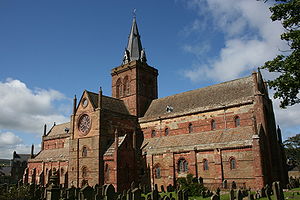
http://www.geograph.org.uk/photo/169537 - St Magnus Cathedral, Orkney
- Stonehaven TolboothStonehaven TolboothThe Stonehaven Tolbooth is a late 16th century stone building originally used as a courthouse and a prison in the town of Stonehaven, Aberdeenshire, Scotland...
, AberdeenshireAberdeenshireAberdeenshire is one of the 32 unitary council areas in Scotland and a lieutenancy area.The present day Aberdeenshire council area does not include the City of Aberdeen, now a separate council area, from which its name derives. Together, the modern council area and the city formed historic...
http://www.geograph.org.uk/photo/108003
Wales
- Raglan CastleRaglan CastleRaglan Castle is a late medieval castle located just north of the village of Raglan in the county of Monmouthshire in south east Wales. The modern castle dates from between the 15th and early 17th-centuries, when the successive ruling families of the Herberts and the Somersets created a luxurious,...
, MonmouthshireMonmouthshireMonmouthshire is a county in south east Wales. The name derives from the historic county of Monmouthshire which covered a much larger area. The largest town is Abergavenny. There are many castles in Monmouthshire .-Historic county:... - Tintern AbbeyTintern AbbeyTintern Abbey was founded by Walter de Clare, Lord of Chepstow, on 9 May 1131. It is situated in the village of Tintern, on the Welsh bank of the River Wye in Monmouthshire, which forms the border between Monmouthshire in Wales and Gloucestershire in England. It was only the second Cistercian...
, MonmouthshireMonmouthshireMonmouthshire is a county in south east Wales. The name derives from the historic county of Monmouthshire which covered a much larger area. The largest town is Abergavenny. There are many castles in Monmouthshire .-Historic county:...
http://www.geograph.org.uk/photo/483441 and http://www.geograph.org.uk/photo/337135