
Dartmoor
Encyclopedia
Dartmoor is an area of moorland
in south Devon
, England
. Protected by National Park
status, it covers 954 square kilometres (368.3 sq mi).
The granite
upland
dates from the Carboniferous
period of geological
history. The moorland is capped with many exposed granite hilltops known as tor
s, providing habitats for Dartmoor wildlife
. The highest point is High Willhays
, 621 m (2,037 ft) above sea level. The entire area is rich in antiquities and archaeology
.
Dartmoor is managed by the Dartmoor National Park Authority
whose 22 members are drawn from Devon County Council
, local district councils and Government.
Parts of Dartmoor have been used as military
firing ranges for over 200 years. The public enjoy extensive access rights to Dartmoor (including restricted access to the firing ranges) and it is a popular tourist
destination. The organisation responsible for tourism on Dartmoor is the Dartmoor Partnership.
in Britain, with about 625 square kilometre at the surface, though most of it is under superficial peat deposits. The granite (or more accurately adamellite) was intruded at depth as a pluton
into the surrounding sedimentary rocks during the Carboniferous
period, probably about 309 million years ago. It is generally accepted that the present surface is not far below the original top of the pluton; evidence for this includes partly digested shale
xenolith
s, contamination of the granite and the existence of two patches of altered sedimentary rock on top of the granite.
A considerable gravity anomaly
is associated with the Dartmoor pluton as with other such plutons
. Measurement of the anomaly has helped to determine the likely shape and extent of the rock mass at depth.
country such as this are usually rounded boulder-like formations. More than 160 of the hills of Dartmoor have the word tor in their name but quite a number do not. However this does not appear to relate to whether or not there is an outcrop of rock on their summit. The tors are the focus of an annual event known as the Ten Tors Challenge, when over 1000 people aged between 14 and 19 walk for distances of 56, 72 or 88 km (35, 45 or 55 mi) between ten tors on many differing routes.
 The highest points on Dartmoor are on the northern moor: High Willhays
, 621 m (2,037.4 ft), and Yes Tor
, 619 m (2,030.8 ft), The highest points on the southern moor are Ryder's Hill
, 515 m (1,689.6 ft), , Snowdon 495 m (1,624 ft), , and an unnamed point of 493 m (1,617.5 ft) at . Probably the best known tor on Dartmoor is Haytor (also spelt Hey Tor), 457 m (1,499.3 ft), . For a more complete list see List of Dartmoor tors and hills.
 The high ground of Dartmoor forms the catchment area
for many of Devon's rivers. As well as shaping the landscape, these have traditionally provided a source of power for moor industries such as tin mining
and quarrying.
The moor takes its name from the River Dart
, which starts as the East Dart and West Dart and then becomes a single river at Dartmeet
. It leaves the moor at Buckfastleigh
, flowing through Totnes
below where it opens up into a long ria
, reaching the sea at Dartmouth
.
For a full list, expand the Rivers of Dartmoor navigational box at the bottom of this page.
, the rain is usually absorbed quickly and distributed slowly, so the moor is rarely dry. In areas where water accumulates, dangerous bog
s or mires can result. Some of these, topped with bright green moss, are known to locals as "feather beds" or "quakers", because they shift (or 'quake') beneath your feet. Quakers result from sphagnum moss growing over the water that accumulates in the hollows in the granite.
The vegetation of the bogs depends on the type and location. Blanket bog
, which forms on the highest land where the rainfall exceeds 2,000 mm (80 in) a year, consists mainly of cotton-grass (Eriophorum species), sedges (Carex
and Rhynchospora
), Bog Asphodel
and Common Tormentil, with Sphagnum
thriving in the wettest patches. The valley bogs have lush growth of rushes
, with sphagnum, cross-leaved heath
, sundews and several other species.
Some of the bogs on Dartmoor have achieved notoriety, the most notable being Fox Tor Mires
, supposedly the inspiration for Great Grimpen Mire in Conan Doyle's novel The Hound of the Baskervilles
, although there is a waymarked footpath across it. Sabine Baring-Gould
, in his Book of Dartmoor (1900) related the story of a man who was making his way through Aune Mire at the head of the River Avon
when he came upon a top-hat brim down on the surface of the mire. He kicked it, whereupon a voice called out: "What be you a-doin' to my 'at?" The man replied, "Be there now a chap under'n?" "Ees, I reckon," was the reply, "and a hoss under me likewise."
, Dartmoor has a temperate climate
which is generally wetter and milder than locations at similar height in the rest of England. At Princetown
, near the centre of the moor at a height of 453 metres (1,486.2 ft), January and February are the coldest months with mean minimum temperatures around 1 °C (34 °F). July and August are the warmest months with mean daily maxima not reaching 18 °C (64 °F). Compared with Teignmouth
, which is on the coast about 22 miles (35.4 km) to the east, the average maximum and minimum temperatures are 3.0 °C and 2.6 °C lower respectively, and frost is at least five times as frequent. On the highest ground, in the north of the moor, the growing season
is less than 175 days - this contrasts with some 300 days along most of the south coast of the county.
Rainfall
tends to be associated with Atlantic depressions
or with convection. In summer, convection caused by solar surface heating sometimes forms shower cloud
s and a large proportion of rainfall falls from showers and thunderstorms at this time of year. The wettest months are November and December and on the highest parts of the moor the average annual total rainfall is over 2000 mm (about 80 in). This compares with less than 800 mm (31.5 in) in the lower land to the east around the Exe Estuary
, which is in the rain shadow
of the moor.
Between 1961 and 1990 Met Office
data shows that there was an average of 20 days when snow fell on the moor, and over 40 days a year with hail, which is as high as anywhere else in the country. This results when cold polar maritime air that has travelled over a large expanse of warmer ocean is forced to rise over high country.
When average temperatures at Princetown between 1961 and 2000 are compared, the average annual temperature in the decade 1990–2000 was up by 0.2 °C, and the late winter temperature increased by 0.5 °C.
and early Bronze Age
. Indeed, Dartmoor contains the largest concentration of Bronze Age remains in the United Kingdom, which suggests that this was when a larger population moved onto the hills of Dartmoor. The large systems of Bronze Age fields, divided by reave
s, cover an area of over 10000 hectare of the lower moors.
The climate at the time was warmer than today, and much of today's moorland was covered with trees. The prehistoric settlers began clearing the forest, and established the first farming communities. Fire was the main method of clearing land, creating pasture
and swidden types of fire-fallow farmland. Areas less suited for farming tended to be burned for livestock grazing. Over the centuries these Neolithic practices greatly expanded the upland moors, and contributed to the acidification of the soil and the accumulation of peat
and bog
s.
The highly acidic soil has ensured that no organic remains have survived, but the durability of the granite has meant that the remains of buildings, enclosures and monuments have survived well, as have flint tools. It should be noted that a number of remains were "restored" by enthusiastic Victorians and that, in some cases, they have placed their own interpretation on how an area may have looked.
s (more usually referred to locally as standing stone
s or longstones), stone circle
s, kistvaen
s, cairn
s and stone row
s are to be found on the moor. The most significant sites include:
Some have L-shaped porches to protect against wind and rain; some particularly good examples are to be found at Grimspound
. It is believed that they would have had a conical roof, supported by timbers and covered in turf or thatch.
There are also numerous kistvaens
, Neolithic stone box-like tombs.
Many ancient structures, including the hut circles at Grimspound, were reconstructed during the 19th century; most notably by civil engineer and historian Richard Hansford Worth. Some of this work was based more on speculation than archaeological expertise, and has since been criticised for its inaccuracy.
 The climate worsened over the course of a thousand years from around 1000 BC, so that much of high Dartmoor was largely abandoned by its early inhabitants.
It was not until the early mediaeval period that the weather again became warmer, and settlers moved back onto the moors. Like their ancient forebears, they also used the natural granite to build their homes, preferring a style known as the longhouse
— some of which are still inhabited today, although they have been clearly adapted over the centuries. Many are now being used as farm buildings, while others were abandoned and fell into ruin.
The earliest surviving farms, still in operation today, are known as the Ancient Tenements
. Most of these date back to the 14th century and sometimes earlier.
Some way into the moor stands the town of Princetown, the site of the notorious Dartmoor Prison
, which was originally built both by, and for, prisoners of war
from the Napoleonic Wars
. The prison has a (now misplaced) reputation for being escape-proof, due to both the buildings themselves and its physical location.
The Dartmoor landscape is scattered with the marks left by the many generations who have lived and worked there over the centuries — such as the remains of the once mighty Dartmoor tin-mining
industry, and farmhouses long since abandoned.
Indeed the industrial archaeology of Dartmoor
is a subject in its own right.
s, a headless horseman, a mysterious pack of 'spectral hounds', and a large black dog. During the Great Thunderstorm
of 1638, Dartmoor town of Widecombe-in-the-moor
was even said to have been visited by the Devil
.
Many landmarks have ancient legends and ghost stories associated with them, such as Jay's Grave
, the ancient burial site at Childe's Tomb
, the rock pile called Bowerman's Nose
, and the stone crosses
that mark mediaeval routes across the moor.
A few stories have emerged in recent decades, such as the 'hairy hands
', that are said to attack travellers on the B3212 near Two Bridges
; and the 'Beast of Dartmoor', a supposed large cat.
Dartmoor has inspired a number of artists and writers, such as Sir Arthur Conan Doyle in The Hound of the Baskervilles
and The Adventure of Silver Blaze, Eden Phillpotts
, Beatrice Chase
, Agatha Christie
, Rosamunde Pilcher
, Laurie King, and the Reverend Sabine Baring-Gould
.
being the major part of this, owned by the Duke of Cornwall
. The Ministry of Defence
owns 14% (see below), 3.8% is owned by water companies (see Dartmoor reservoirs
), 3.7% by the National Trust
, 1.8% by the Forestry Commission
and 1.4% by Dartmoor's national park authority
. About 37% of Dartmoor is common land
.
Dartmoor differs from some other National Parks in England and Wales
, in that since the Dartmoor Commons Act 1985 much of it has been designated as 'Access Land', which, although it remains privately owned, has no restrictions on where walkers can roam. In addition to this Access Land, there are about 730 km (454 mi) of public rights of way on Dartmoor, and many kilometres of permitted footpaths and bridleways where the owner allows access.
Because of the 1985 Act, Dartmoor was largely unaffected by the Countryside and Rights of Way Act 2000
, which established similar rights in other rural parts of the country, but in 2006, this Act opened up much of the remaining restricted land to walkers.
. There is still a large British Army
training camp at Okehampton
— also the site of an airbase during the Second World War
.
The Ministry of Defence
(MoD) uses three areas of the northern moor for manoeuvres and live-firing exercises, totalling 108.71 square kilometres (42 sq mi), or just over 11% of the National Park. Red and white posts mark the boundaries of these military areas (shown on Ordnance Survey
1:25,000 scale maps). Flagpoles on many tors in and around the ranges fly red flags when firing is taking place. At other times, members of the public are allowed access. Blank rounds may also be used, but the MoD does not notify the public of this in advance.
Some "challenge" and charitable
events take place with assistance of the military on Dartmoor including the long established Ten Tors
event and the more recent Dartmoor Beast
.
 Throughout human history, the landscape has been exploited for industrial purposes. In recent years, controversy has surrounded the work of industrial conglomerates Imerys
and Sibelco (formerly Watts Blake Bearne), who have used parts of the moor for china clay mining
. Licences were granted by the British Government but were recently renounced after sustained public pressure from bodies such as the Dartmoor Preservation Association
. Many of these licences pre-date much of the heavy machinery which is in use today. Imerys were singled out for particular criticism after work at Lee Moor destroyed a number of archaeologically significant sites.
The British government has made promises to protect the integrity of the moor; however, the cost of compensating companies for these licences, which may not have been granted in today's political climate, could prove prohibitive.
The military use of the moor has been another source of controversy, such as when training was extended in January 2003. The national park authority
received 1,700 objections before making the decision. Objectors claimed that Dartmoor should be an area for recreation, and that the training disturbs the peace.
Those who objected included the Open Spaces Society
and the Dartmoor Preservation Association
. During her lifetime, Lady Sayer
was another outspoken critic of the damage which she perceived that the army was doing to the moor.
of about 33,000, which swells considerably during holiday periods with incoming tourists. The largest settlements within the National Park are Ashburton
(the largest with population about 3,500), Buckfastleigh
, Moretonhampstead
, Princetown
, Yelverton
, Horrabridge
, South Brent
, Christow
and Chagford
.
For a full list, expand the Settlements of Dartmoor navigational box at the bottom of this page.
's opinion was that it is a "dreary mountainous tract". At the turn of the 19th century John Swete was one of the first people to visit Dartmoor for pleasure and his journals and watercolour paintings now provide a valuable historical resource.
The oldest leisure pursuit on the moor is hill walking. William Crossing
's definitive Guide to Dartmoor was published in 1909, and in 1938 a plaque and letterbox in his memory were placed at Duck's Pool
on the southern moor. Parts of the Two Moors Way
and the Templer Way are on Dartmoor.
Letterboxing
originated on Dartmoor in the 19th century and has become increasingly popular in recent decades. Watertight containers, or 'letterboxes', are hidden throughout the moor, each containing a visitor's book and a rubber stamp. Visitors take an impression of the letterbox's rubber stamp as proof of finding the box and record their visit by stamping their own personal stamp in the letterbox's logbook. A recent related development is geocaching
. Geocache clues make use of GPS
coordinates, whereas letterboxing clues tend to consist of grid references and compass bearings.
Whitewater kayaking
and canoeing
are popular on the rivers due to the high rainfall and their high quality, though for environmental reasons access is restricted to the winter months. The River Dart
is the most prominent meeting place, the section known as the Loop
being particularly popular. Other white water rivers are the Erme, Tavy, Plym and Meavy.
Other activities are rock climbing
on the granite tors and outcrops, some of the well-known venues being Haytor, Hound Tor
and The Dewerstone; horse riding, which can be undertaken on any of the common land
; cycling (but not on open moorland); and angling for wild brown trout
, sea trout and salmon
—although much of the river fishing on Dartmoor is privately owned, permits are available for some stretches.
Moorland
Moorland or moor is a type of habitat, in the temperate grasslands, savannas, and shrublands biome, found in upland areas, characterised by low-growing vegetation on acidic soils and heavy fog...
in south Devon
Devon
Devon is a large county in southwestern England. The county is sometimes referred to as Devonshire, although the term is rarely used inside the county itself as the county has never been officially "shired", it often indicates a traditional or historical context.The county shares borders with...
, England
England
England is a country that is part of the United Kingdom. It shares land borders with Scotland to the north and Wales to the west; the Irish Sea is to the north west, the Celtic Sea to the south west, with the North Sea to the east and the English Channel to the south separating it from continental...
. Protected by National Park
National parks of England and Wales
The national parks of England and Wales are areas of relatively undeveloped and scenic landscape that are designated under the National Parks and Access to the Countryside Act 1949...
status, it covers 954 square kilometres (368.3 sq mi).
The granite
Granite
Granite is a common and widely occurring type of intrusive, felsic, igneous rock. Granite usually has a medium- to coarse-grained texture. Occasionally some individual crystals are larger than the groundmass, in which case the texture is known as porphyritic. A granitic rock with a porphyritic...
upland
Highland (geography)
The term highland or upland is used to denote any mountainous region or elevated mountainous plateau. Generally speaking, the term upland tends to be used for ranges of hills, typically up to 500-600m, and highland for ranges of low mountains.The Scottish Highlands refers to the mountainous...
dates from the Carboniferous
Carboniferous
The Carboniferous is a geologic period and system that extends from the end of the Devonian Period, about 359.2 ± 2.5 Mya , to the beginning of the Permian Period, about 299.0 ± 0.8 Mya . The name is derived from the Latin word for coal, carbo. Carboniferous means "coal-bearing"...
period of geological
Geology
Geology is the science comprising the study of solid Earth, the rocks of which it is composed, and the processes by which it evolves. Geology gives insight into the history of the Earth, as it provides the primary evidence for plate tectonics, the evolutionary history of life, and past climates...
history. The moorland is capped with many exposed granite hilltops known as tor
Tor (geography)
A tor is a large, free-standing residual mass that rises abruptly from the surrounding smooth and gentle slopes of a rounded hill summit or ridge crest...
s, providing habitats for Dartmoor wildlife
Dartmoor wildlife
Dartmoor and the fact that a great deal of it is undisturbed for much of the year is an encouragement to the wildlife.The more common mammals include: Dartmoor ponies, rabbits, foxes, otters, badgers, grey squirrels, weasels, stoats, hares and deer...
. The highest point is High Willhays
High Willhays
High Willhays or, according to some authors, High Willes is the highest point on Dartmoor, Devon, at 621 metres above sea level, and the highest point in Great Britain south of the Brecon Beacons.-Toponymy:...
, 621 m (2,037 ft) above sea level. The entire area is rich in antiquities and archaeology
Archaeology
Archaeology, or archeology , is the study of human society, primarily through the recovery and analysis of the material culture and environmental data that they have left behind, which includes artifacts, architecture, biofacts and cultural landscapes...
.
Dartmoor is managed by the Dartmoor National Park Authority
National Park Authority
A national park authority is a special term used in the United Kingdom for the legal body in charge of a national park. The powers and duties of the authorities are all similar, but do vary somewhat depending on the country in which they are situated....
whose 22 members are drawn from Devon County Council
Devon County Council
Devon County Council is the county council administering the English county of Devon. Based in the city of Exeter, the council covers the non-metropolitan county area of Devon...
, local district councils and Government.
Parts of Dartmoor have been used as military
Military
A military is an organization authorized by its greater society to use lethal force, usually including use of weapons, in defending its country by combating actual or perceived threats. The military may have additional functions of use to its greater society, such as advancing a political agenda e.g...
firing ranges for over 200 years. The public enjoy extensive access rights to Dartmoor (including restricted access to the firing ranges) and it is a popular tourist
Tourism
Tourism is travel for recreational, leisure or business purposes. The World Tourism Organization defines tourists as people "traveling to and staying in places outside their usual environment for not more than one consecutive year for leisure, business and other purposes".Tourism has become a...
destination. The organisation responsible for tourism on Dartmoor is the Dartmoor Partnership.
Geology
Dartmoor includes the largest area of graniteGranite
Granite is a common and widely occurring type of intrusive, felsic, igneous rock. Granite usually has a medium- to coarse-grained texture. Occasionally some individual crystals are larger than the groundmass, in which case the texture is known as porphyritic. A granitic rock with a porphyritic...
in Britain, with about 625 square kilometre at the surface, though most of it is under superficial peat deposits. The granite (or more accurately adamellite) was intruded at depth as a pluton
Pluton
A pluton in geology is a body of intrusive igneous rock that crystallized from magma slowly cooling below the surface of the Earth. Plutons include batholiths, dikes, sills, laccoliths, lopoliths, and other igneous bodies...
into the surrounding sedimentary rocks during the Carboniferous
Carboniferous
The Carboniferous is a geologic period and system that extends from the end of the Devonian Period, about 359.2 ± 2.5 Mya , to the beginning of the Permian Period, about 299.0 ± 0.8 Mya . The name is derived from the Latin word for coal, carbo. Carboniferous means "coal-bearing"...
period, probably about 309 million years ago. It is generally accepted that the present surface is not far below the original top of the pluton; evidence for this includes partly digested shale
Shale
Shale is a fine-grained, clastic sedimentary rock composed of mud that is a mix of flakes of clay minerals and tiny fragments of other minerals, especially quartz and calcite. The ratio of clay to other minerals is variable. Shale is characterized by breaks along thin laminae or parallel layering...
xenolith
Xenolith
A xenolith is a rock fragment which becomes enveloped in a larger rock during the latter's development and hardening. In geology, the term xenolith is almost exclusively used to describe inclusions in igneous rock during magma emplacement and eruption...
s, contamination of the granite and the existence of two patches of altered sedimentary rock on top of the granite.
A considerable gravity anomaly
Gravity anomaly
A gravity anomaly is the difference between the observed acceleration of Earth's gravity and a value predicted from a model.-Geodesy and geophysics:...
is associated with the Dartmoor pluton as with other such plutons
Gravity anomalies of Britain and Ireland
Variations in the strength of gravity occur from place to place according to the density distribution of the rocks beneath the surface. Such gravity anomalies have been mapped across the British Isles and the surrounding seas and they reveal aspects of these islands’ geological structure.-Negative...
. Measurement of the anomaly has helped to determine the likely shape and extent of the rock mass at depth.
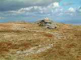
Tors
Dartmoor is known for its tors — hills topped with outcrops of bedrock, which in graniteGranite
Granite is a common and widely occurring type of intrusive, felsic, igneous rock. Granite usually has a medium- to coarse-grained texture. Occasionally some individual crystals are larger than the groundmass, in which case the texture is known as porphyritic. A granitic rock with a porphyritic...
country such as this are usually rounded boulder-like formations. More than 160 of the hills of Dartmoor have the word tor in their name but quite a number do not. However this does not appear to relate to whether or not there is an outcrop of rock on their summit. The tors are the focus of an annual event known as the Ten Tors Challenge, when over 1000 people aged between 14 and 19 walk for distances of 56, 72 or 88 km (35, 45 or 55 mi) between ten tors on many differing routes.
High Willhays
High Willhays or, according to some authors, High Willes is the highest point on Dartmoor, Devon, at 621 metres above sea level, and the highest point in Great Britain south of the Brecon Beacons.-Toponymy:...
, 621 m (2,037.4 ft), and Yes Tor
Yes Tor
Yes Tor is the second highest point on Dartmoor, Devon, South West England, at above sea level. Together with nearby High Willhays they are the only two peaks above south of the English Peak District National Park....
, 619 m (2,030.8 ft), The highest points on the southern moor are Ryder's Hill
Ryder's Hill
At 515 m, Ryder's Hill is one of the highest points on the southern part of Dartmoor, Devon, England. On its summit there are two standing stones and a low cairn, on top of which is a triangulation pillar....
, 515 m (1,689.6 ft), , Snowdon 495 m (1,624 ft), , and an unnamed point of 493 m (1,617.5 ft) at . Probably the best known tor on Dartmoor is Haytor (also spelt Hey Tor), 457 m (1,499.3 ft), . For a more complete list see List of Dartmoor tors and hills.
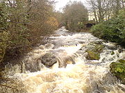
Rivers
Drainage basin
A drainage basin is an extent or an area of land where surface water from rain and melting snow or ice converges to a single point, usually the exit of the basin, where the waters join another waterbody, such as a river, lake, reservoir, estuary, wetland, sea, or ocean...
for many of Devon's rivers. As well as shaping the landscape, these have traditionally provided a source of power for moor industries such as tin mining
Dartmoor tin-mining
The Dartmoor tin mining industry is thought to have originated in pre-Roman times, and continued right through to the 20th century. From the 12th century onwards tin mining was regulated by a Stannary Parliament which had its own laws....
and quarrying.
The moor takes its name from the River Dart
River Dart
The River Dart is a river in Devon, England which rises high on Dartmoor, and releases to the sea at Dartmouth. Its valley and surrounding area is a place of great natural beauty.-Watercourse:...
, which starts as the East Dart and West Dart and then becomes a single river at Dartmeet
Dartmeet
Dartmeet is a popular tourist spot in the centre of Dartmoor, Devon, England at .It lies at the end of the B3351 road, about east of Two Bridges. From here, the road continues eastwards as a minor road with restrictions on the size of vehicles, past Poundsgate and over Holne Bridge and New Bridge...
. It leaves the moor at Buckfastleigh
Buckfastleigh
Buckfastleigh is a small market town and civil parish in Devon, England situated beside the Devon Expressway at the edge of the Dartmoor National Park. It is part of Teignbridge District and, for ecclesiastical purposes lies within the Totnes Deanery. It has a population of 3,661...
, flowing through Totnes
Totnes
Totnes is a market town and civil parish at the head of the estuary of the River Dart in Devon, England within the South Devon Area of Outstanding Natural Beauty...
below where it opens up into a long ria
Ria
A ria is a coastal inlet formed by the partial submergence of an unglaciated river valley. It is a drowned river valley that remains open to the sea. Typically, rias have a dendritic, treelike outline although they can be straight and without significant branches. This pattern is inherited from the...
, reaching the sea at Dartmouth
Dartmouth, Devon
Dartmouth is a town and civil parish in the English county of Devon. It is a tourist destination set on the banks of the estuary of the River Dart, which is a long narrow tidal ria that runs inland as far as Totnes...
.
For a full list, expand the Rivers of Dartmoor navigational box at the bottom of this page.
Bogs
Much more rain falls on Dartmoor than in the surrounding lowlands. As much of the national park is covered in thick layers of peatPeat
Peat is an accumulation of partially decayed vegetation matter or histosol. Peat forms in wetland bogs, moors, muskegs, pocosins, mires, and peat swamp forests. Peat is harvested as an important source of fuel in certain parts of the world...
, the rain is usually absorbed quickly and distributed slowly, so the moor is rarely dry. In areas where water accumulates, dangerous bog
Bog
A bog, quagmire or mire is a wetland that accumulates acidic peat, a deposit of dead plant material—often mosses or, in Arctic climates, lichens....
s or mires can result. Some of these, topped with bright green moss, are known to locals as "feather beds" or "quakers", because they shift (or 'quake') beneath your feet. Quakers result from sphagnum moss growing over the water that accumulates in the hollows in the granite.
The vegetation of the bogs depends on the type and location. Blanket bog
Blanket bog
Blanket bog or blanket mire is an area of peatland, forming where there is a climate of high rainfall and a low level of evapotranspiration, allowing peat to develop not only in wet hollows but over large expanses of undulating ground. The blanketing of the ground with a variable depth of peat...
, which forms on the highest land where the rainfall exceeds 2,000 mm (80 in) a year, consists mainly of cotton-grass (Eriophorum species), sedges (Carex
Carex
Carex is a genus of plants in the family Cyperaceae, commonly known as sedges. Other members of the Cyperaceae family are also called sedges, however those of genus Carex may be called "true" sedges, and it is the most species-rich genus in the family. The study of Carex is known as...
and Rhynchospora
Rhynchospora
Rhynchospora is a genus of about 250-300 species of sedges with a cosmopolitan distribution. The genus includes both annual and perennial species, mostly with erect 3-sided stems and 3-ranked leaves...
), Bog Asphodel
Bog Asphodel
Narthecium ossifragum, commonly known as bog-, Lancashire- or bastard asphodel, is a plant of Western Europe, found on wet, boggy moorlands up to about 1000 m. It produces spikes of bright yellow flowers in summer. The bright orange fruits have been used as a colourant to replace saffron by...
and Common Tormentil, with Sphagnum
Sphagnum
Sphagnum is a genus of between 151 and 350 species of mosses commonly called peat moss, due to its prevalence in peat bogs and mires. A distinction is made between sphagnum moss, the live moss growing on top of a peat bog on one hand, and sphagnum peat moss or sphagnum peat on the other, the...
thriving in the wettest patches. The valley bogs have lush growth of rushes
Juncaceae
Juncaceae, the rush family, are a monocotyledonous family of flowering plants. There are eight genera and about 400 species. Members of the Juncaceae are slow-growing, rhizomatous, herbaceous plants, and they may superficially resemble grasses. They often grow on infertile soils in a wide range...
, with sphagnum, cross-leaved heath
Erica tetralix
Erica tetralix is a species of heather found in Atlantic areas of Europe, from southern Portugal to central Norway, as well as a number of boggy regions further from the coast in Central Europe. In bogs, wet heaths and damp coniferous woodland, Erica tetralix can become a dominant part of the flora...
, sundews and several other species.
Some of the bogs on Dartmoor have achieved notoriety, the most notable being Fox Tor Mires
Fox Tor
Fox Tor is a relatively minor tor on Dartmoor in the United Kingdom. It is probably best known for the swampy land that lies beneath it, Fox Tor Mires. This is said to have been the inspiration for the fictional Grimpen Mire in the novel The Hound of the Baskervilles by Sir Arthur Conan Doyle...
, supposedly the inspiration for Great Grimpen Mire in Conan Doyle's novel The Hound of the Baskervilles
The Hound of the Baskervilles
The Hound of the Baskervilles is the third of four crime novels by Sir Arthur Conan Doyle featuring the detective Sherlock Holmes. Originally serialised in The Strand Magazine from August 1901 to April 1902, it is set largely on Dartmoor in Devon in England's West Country and tells the story of an...
, although there is a waymarked footpath across it. Sabine Baring-Gould
Sabine Baring-Gould
The Reverend Sabine Baring-Gould was an English hagiographer, antiquarian, novelist and eclectic scholar. His bibliography consists of more than 1240 publications, though this list continues to grow. His family home, Lew Trenchard Manor near Okehampton, Devon, has been preserved as he had it...
, in his Book of Dartmoor (1900) related the story of a man who was making his way through Aune Mire at the head of the River Avon
River Avon, Devon
The River Avon, also known as the River Aune, is a river in the county of Devon in the south of England. It rises in the southern half of Dartmoor National Park in an area of bog to the west of Ryder's Hill. Close to where the river leaves Dartmoor a dam was built in 1957 to form the Avon reservoir...
when he came upon a top-hat brim down on the surface of the mire. He kicked it, whereupon a voice called out: "What be you a-doin' to my 'at?" The man replied, "Be there now a chap under'n?" "Ees, I reckon," was the reply, "and a hoss under me likewise."
Climate
Along with the rest of South West EnglandSouth West England
South West England is one of the regions of England defined by the Government of the United Kingdom for statistical and other purposes. It is the largest such region in area, covering and comprising Bristol, Gloucestershire, Somerset, Dorset, Wiltshire, Devon, Cornwall and the Isles of Scilly. ...
, Dartmoor has a temperate climate
Temperate
In geography, temperate or tepid latitudes of the globe lie between the tropics and the polar circles. The changes in these regions between summer and winter are generally relatively moderate, rather than extreme hot or cold...
which is generally wetter and milder than locations at similar height in the rest of England. At Princetown
Princetown
Princetown is a town situated on Dartmoor in the English county of Devon.In 1785, Sir Thomas Tyrwhitt, Secretary to the Prince of Wales, leased a large area of moorland from the Duchy of Cornwall estate, hoping to convert it into good farmland. He encouraged people to live in the area and suggested...
, near the centre of the moor at a height of 453 metres (1,486.2 ft), January and February are the coldest months with mean minimum temperatures around 1 °C (34 °F). July and August are the warmest months with mean daily maxima not reaching 18 °C (64 °F). Compared with Teignmouth
Teignmouth
Teignmouth is a town and civil parish in Teignbridge in the English county of Devon, situated on the north bank of the estuary mouth of the River Teign about 14 miles south of Exeter. It has a population of 14,413. In 1690, it was the last place in England to be invaded by a foreign power...
, which is on the coast about 22 miles (35.4 km) to the east, the average maximum and minimum temperatures are 3.0 °C and 2.6 °C lower respectively, and frost is at least five times as frequent. On the highest ground, in the north of the moor, the growing season
Growing season
In botany, horticulture, and agriculture the growing season is the period of each year when native plants and ornamental plants grow; and when crops can be grown....
is less than 175 days - this contrasts with some 300 days along most of the south coast of the county.
Rainfall
Precipitation (meteorology)
In meteorology, precipitation In meteorology, precipitation In meteorology, precipitation (also known as one of the classes of hydrometeors, which are atmospheric water phenomena is any product of the condensation of atmospheric water vapor that falls under gravity. The main forms of precipitation...
tends to be associated with Atlantic depressions
Low pressure area
A low-pressure area, or "low", is a region where the atmospheric pressure at sea level is below that of surrounding locations. Low-pressure systems form under areas of wind divergence which occur in upper levels of the troposphere. The formation process of a low-pressure area is known as...
or with convection. In summer, convection caused by solar surface heating sometimes forms shower cloud
Cloud
A cloud is a visible mass of liquid droplets or frozen crystals made of water and/or various chemicals suspended in the atmosphere above the surface of a planetary body. They are also known as aerosols. Clouds in Earth's atmosphere are studied in the cloud physics branch of meteorology...
s and a large proportion of rainfall falls from showers and thunderstorms at this time of year. The wettest months are November and December and on the highest parts of the moor the average annual total rainfall is over 2000 mm (about 80 in). This compares with less than 800 mm (31.5 in) in the lower land to the east around the Exe Estuary
Exe Estuary
The Exe Estuary is an estuary on the south coast of Devon, England.The estuary starts just to the south of the city of Exeter, and extends south for approximately eight miles to meet the English Channel...
, which is in the rain shadow
Rain shadow
A rain shadow is a dry area on the lee side of a mountainous area. The mountains block the passage of rain-producing weather systems, casting a "shadow" of dryness behind them. As shown by the diagram to the right, the warm moist air is "pulled" by the prevailing winds over a mountain...
of the moor.
Between 1961 and 1990 Met Office
Met Office
The Met Office , is the United Kingdom's national weather service, and a trading fund of the Department for Business, Innovation and Skills...
data shows that there was an average of 20 days when snow fell on the moor, and over 40 days a year with hail, which is as high as anywhere else in the country. This results when cold polar maritime air that has travelled over a large expanse of warmer ocean is forced to rise over high country.
When average temperatures at Princetown between 1961 and 2000 are compared, the average annual temperature in the decade 1990–2000 was up by 0.2 °C, and the late winter temperature increased by 0.5 °C.
Pre-history
The majority of the prehistoric remains on Dartmoor date back to the late NeolithicNeolithic
The Neolithic Age, Era, or Period, or New Stone Age, was a period in the development of human technology, beginning about 9500 BC in some parts of the Middle East, and later in other parts of the world. It is traditionally considered as the last part of the Stone Age...
and early Bronze Age
Bronze Age
The Bronze Age is a period characterized by the use of copper and its alloy bronze as the chief hard materials in the manufacture of some implements and weapons. Chronologically, it stands between the Stone Age and Iron Age...
. Indeed, Dartmoor contains the largest concentration of Bronze Age remains in the United Kingdom, which suggests that this was when a larger population moved onto the hills of Dartmoor. The large systems of Bronze Age fields, divided by reave
Reave
A reave is a long and generally straight boundary wall made of stone that was built during the Bronze Age. Reaves were identified as prehistoric features on Dartmoor in Devon, England in 1972, and although they had been described by antiquarians in the 1820s, the knowledge of their origins had been...
s, cover an area of over 10000 hectare of the lower moors.
The climate at the time was warmer than today, and much of today's moorland was covered with trees. The prehistoric settlers began clearing the forest, and established the first farming communities. Fire was the main method of clearing land, creating pasture
Pasture
Pasture is land used for grazing. Pasture lands in the narrow sense are enclosed tracts of farmland, grazed by domesticated livestock, such as horses, cattle, sheep or swine. The vegetation of tended pasture, forage, consists mainly of grasses, with an interspersion of legumes and other forbs...
and swidden types of fire-fallow farmland. Areas less suited for farming tended to be burned for livestock grazing. Over the centuries these Neolithic practices greatly expanded the upland moors, and contributed to the acidification of the soil and the accumulation of peat
Peat
Peat is an accumulation of partially decayed vegetation matter or histosol. Peat forms in wetland bogs, moors, muskegs, pocosins, mires, and peat swamp forests. Peat is harvested as an important source of fuel in certain parts of the world...
and bog
Bog
A bog, quagmire or mire is a wetland that accumulates acidic peat, a deposit of dead plant material—often mosses or, in Arctic climates, lichens....
s.
The highly acidic soil has ensured that no organic remains have survived, but the durability of the granite has meant that the remains of buildings, enclosures and monuments have survived well, as have flint tools. It should be noted that a number of remains were "restored" by enthusiastic Victorians and that, in some cases, they have placed their own interpretation on how an area may have looked.
Standing stones
Numerous menhirMenhir
A menhir is a large upright standing stone. Menhirs may be found singly as monoliths, or as part of a group of similar stones. Their size can vary considerably; but their shape is generally uneven and squared, often tapering towards the top...
s (more usually referred to locally as standing stone
Standing stone
Standing stones, orthostats, liths, or more commonly megaliths are solitary stones set vertically in the ground and come in many different varieties....
s or longstones), stone circle
Stone circle
A stone circle is a monument of standing stones arranged in a circle. Such monuments have been constructed across the world throughout history for many different reasons....
s, kistvaen
Dartmoor kistvaens
Dartmoor kistvaens are burial tombs or cists from the Neolithic age, i.e. they are approximately 4,000 years old. Kistvaens have been found in many places, including Dartmoor, a 954 square kilometre area of moorland in south Devon, England. The box-like stone tombs were created when the ancient...
s, cairn
Cairn
Cairn is a term used mainly in the English-speaking world for a man-made pile of stones. It comes from the or . Cairns are found all over the world in uplands, on moorland, on mountaintops, near waterways and on sea cliffs, and also in barren desert and tundra areas...
s and stone row
Stone row
A stone row , is a linear arrangement of upright, parallel megalithic standing stones set at intervals along a common axis or series of axes, usually dating from the later Neolithic or Bronze Age. Rows may be individual or grouped, and three or more stones aligned can constitute a stone row...
s are to be found on the moor. The most significant sites include:
- Upper Erme stone row is the longest on Dartmoor and in fact in the world at 3300 m (10,826.8 ft)
- Beardown Man, near Devil's Tor — isolated standing stone 3.5 metre high, said to have another 1 metre below ground.
- Challacombe, near the prehistoric settlement of GrimspoundGrimspoundGrimspound is a late Bronze Age settlement, situated on Dartmoor in Devon, England. It consists of a set of 24 hut circles surrounded by a low stone wall...
— triple stone row. - DrizzlecombeDrizzlecombeDrizzlecombe or Thrushelcombe is an area of Dartmoor in the county of Devon, England. It is located on the western side of the moor about east of the village of Yelverton, to the west of the upper reaches of the River Plym....
, east of SheepstorSheepstorSheepstor is a village and civil parish on the western side of Dartmoor in the county of Devon, England. In 2001 its population was 53, down from 95 in 1901. For administrative purposes the parish is grouped with the parishes of Meavy and Walkhampton to form Burrator Parish Council, and for...
village — stone circles, rows, standing stones, kistvaens and cairns. - Grey WethersGrey WethersGrey Wethers consists of a pair of prehistoric stone circles, situated on grassy plateau to the north of Postbridge, Dartmoor, in the United Kingdom....
, near PostbridgePostbridge, DevonPostbridge is a hamlet in the heart of Dartmoor in the English county of Devon. It is situated on the B3212, roughly midway between Princetown and Moretonhampstead....
— double circle, aligned almost exactly north south. - Laughter Tor, near Two BridgesTwo BridgesTwo Bridges is an isolated location in the heart of Dartmoor National Park in Devon, England. It is situated around north east of Princetown on the old turnpike road which was built across Dartmoor in the late 18th century ....
— standing stone 2.4 m (7.9 ft) high and two double stone rows, one 164 m (538.1 ft) long. - MerrivaleMerrivale, DevonMerrivale is a locality in western Dartmoor, in the West Devon district of Devon, England. It is best known for the nearby series of Bronze Age megalithic monuments to the south and a former granite quarry.-Merrivale hamlet:...
, between PrincetownPrincetownPrincetown is a town situated on Dartmoor in the English county of Devon.In 1785, Sir Thomas Tyrwhitt, Secretary to the Prince of Wales, leased a large area of moorland from the Duchy of Cornwall estate, hoping to convert it into good farmland. He encouraged people to live in the area and suggested...
and Tavistock — includes a double stone row 182 m (597.1 ft) long, 1.1 m (3.6 ft) wide, aligned almost exactly east-west), stone circles and a kistvaen. - Scorhill , west of ChagfordChagfordChagford is a small town and civil parish on the north-east edge of Dartmoor, in Devon, England, close to the River Teign. It is located off the A382, about 4 miles west of Moretonhampstead. The name Chagford is derived from the word chag, meaning gorse or broom, and the ford suffix indicates its...
— circle, 26.8 m (87.9 ft) in circumference, and stone rows. - Shovel Down, north of Fernworthy reservoirDartmoor reservoirsOver the course of the 19th and 20th centuries, a number of reservoirs and dams were built in the area now covered by Dartmoor National Park in Devon, England to supply drinking water to the rapidly growing towns in the surrounding lowlands. With its deep valleys and high rainfall, Dartmoor was an...
— double stone row approximately 120 m (393.7 ft) long. - Yellowmead DownYellowmead DownYellowmead Down near Sheepstor in Devon, England, is a Bronze Age concentric stone circle consisting of four rings of stones set within one another. The largest is 20m wide and the smallest, 6m....
, a quadruple concentric stone circle and stone rows.
Hut circles and kistvaens
There are also an estimated 5,000 hut circles still surviving, despite the fact that many have been raided over the centuries by the builders of the traditional dry stone walls. These are the remnants of Bronze Age houses. The smallest are around 1.8 m (6 ft) in diameter, and the largest may be up to five times this size.Some have L-shaped porches to protect against wind and rain; some particularly good examples are to be found at Grimspound
Grimspound
Grimspound is a late Bronze Age settlement, situated on Dartmoor in Devon, England. It consists of a set of 24 hut circles surrounded by a low stone wall...
. It is believed that they would have had a conical roof, supported by timbers and covered in turf or thatch.
There are also numerous kistvaens
Dartmoor kistvaens
Dartmoor kistvaens are burial tombs or cists from the Neolithic age, i.e. they are approximately 4,000 years old. Kistvaens have been found in many places, including Dartmoor, a 954 square kilometre area of moorland in south Devon, England. The box-like stone tombs were created when the ancient...
, Neolithic stone box-like tombs.
Many ancient structures, including the hut circles at Grimspound, were reconstructed during the 19th century; most notably by civil engineer and historian Richard Hansford Worth. Some of this work was based more on speculation than archaeological expertise, and has since been criticised for its inaccuracy.
The historical period
It was not until the early mediaeval period that the weather again became warmer, and settlers moved back onto the moors. Like their ancient forebears, they also used the natural granite to build their homes, preferring a style known as the longhouse
Dartmoor longhouse
The Dartmoor longhouse is a type of traditional home, found on the high ground of Dartmoor, in Devon, England and belong to a wider tradition of combining human residences with those of livestock under a single roof. The earliest are thought to have been built in the 13th century, and they...
— some of which are still inhabited today, although they have been clearly adapted over the centuries. Many are now being used as farm buildings, while others were abandoned and fell into ruin.
The earliest surviving farms, still in operation today, are known as the Ancient Tenements
Ancient Tenements
The Ancient Tenements are the oldest surviving farms on Dartmoor, in England. They have been established here since 14th century, and possibly earlier....
. Most of these date back to the 14th century and sometimes earlier.
Some way into the moor stands the town of Princetown, the site of the notorious Dartmoor Prison
Dartmoor (HM Prison)
HM Prison Dartmoor is a Category C men's prison, located in Princetown, high on Dartmoor in the English county of Devon. Its high granite walls dominate this area of the moor...
, which was originally built both by, and for, prisoners of war
Prisoner of war
A prisoner of war or enemy prisoner of war is a person, whether civilian or combatant, who is held in custody by an enemy power during or immediately after an armed conflict...
from the Napoleonic Wars
Napoleonic Wars
The Napoleonic Wars were a series of wars declared against Napoleon's French Empire by opposing coalitions that ran from 1803 to 1815. As a continuation of the wars sparked by the French Revolution of 1789, they revolutionised European armies and played out on an unprecedented scale, mainly due to...
. The prison has a (now misplaced) reputation for being escape-proof, due to both the buildings themselves and its physical location.
The Dartmoor landscape is scattered with the marks left by the many generations who have lived and worked there over the centuries — such as the remains of the once mighty Dartmoor tin-mining
Dartmoor tin-mining
The Dartmoor tin mining industry is thought to have originated in pre-Roman times, and continued right through to the 20th century. From the 12th century onwards tin mining was regulated by a Stannary Parliament which had its own laws....
industry, and farmhouses long since abandoned.
Indeed the industrial archaeology of Dartmoor
Industrial archaeology of Dartmoor
The industrial archaeology of Dartmoor covers a number of the industries which have, over the ages, taken place on Dartmoor, and the remaining evidence surrounding them...
is a subject in its own right.
Myths and literature
Dartmoor abounds with myths and legends. It is reputedly the haunt of pixiePixie
Pixies are mythical creatures of folklore, considered to be particularly concentrated in the areas around Devon and Cornwall, suggesting some Celtic origin for the belief and name.They are usually depicted with pointed ears, and often wearing a green outfit and pointed...
s, a headless horseman, a mysterious pack of 'spectral hounds', and a large black dog. During the Great Thunderstorm
The Great Thunderstorm, Widecombe
The Great Thunderstorm of Widecombe-in-the-Moor in Dartmoor, Kingdom of England, took place on Sunday, 21 October 1638, when the church of St Pancras was apparently struck by a ball lightning during a severe thunderstorm. An afternoon service was taking place at the time, and the building was...
of 1638, Dartmoor town of Widecombe-in-the-moor
Widecombe-in-the-Moor
Widecombe-in-the-Moor is a small village located within the heart of the Dartmoor National Park in Devon, England. . The name is thought to derive from 'Withy-combe' which means Willow Valley....
was even said to have been visited by the Devil
Devil
The Devil is believed in many religions and cultures to be a powerful, supernatural entity that is the personification of evil and the enemy of God and humankind. The nature of the role varies greatly...
.
Many landmarks have ancient legends and ghost stories associated with them, such as Jay's Grave
Jay's Grave
Jay's Grave is supposedly the last resting place of a suicide victim who is thought to have died in the late 18th century...
, the ancient burial site at Childe's Tomb
Childe's Tomb
Childe's Tomb is a granite cross on Dartmoor, Devon, England. Although not in its original form, it is more elaborate than most of the crosses on Dartmoor, being raised upon a constructed base, and it is known that a kistvaen is underneath....
, the rock pile called Bowerman's Nose
Bowerman's Nose
Bowerman's Nose is a stack of weathered granite on Dartmoor, Devon, England. It is situated on the northern slopes of Hayne Down, about a mile from Hound Tor and close to the village of Manaton at...
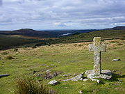
, and the stone crosses
Dartmoor crosses
The Dartmoor crosses are a series of stone crosses found in Dartmoor National Park in the centre of Devon, England. Many of them are old navigational aids, needed because of the remoteness of the moorland and its typically bad weather. Some mark medieval routes between abbeys...
that mark mediaeval routes across the moor.
A few stories have emerged in recent decades, such as the 'hairy hands
Hairy hands
The Hairy Hands is a ghost story/legend that built up around a stretch of road in Dartmoor, United Kingdom, which was purported to have seen an unusually high number of motor vehicle accidents during the early 20th century.-Location:...
', that are said to attack travellers on the B3212 near Two Bridges
Two Bridges
Two Bridges is an isolated location in the heart of Dartmoor National Park in Devon, England. It is situated around north east of Princetown on the old turnpike road which was built across Dartmoor in the late 18th century ....
; and the 'Beast of Dartmoor', a supposed large cat.
Dartmoor has inspired a number of artists and writers, such as Sir Arthur Conan Doyle in The Hound of the Baskervilles
The Hound of the Baskervilles
The Hound of the Baskervilles is the third of four crime novels by Sir Arthur Conan Doyle featuring the detective Sherlock Holmes. Originally serialised in The Strand Magazine from August 1901 to April 1902, it is set largely on Dartmoor in Devon in England's West Country and tells the story of an...
and The Adventure of Silver Blaze, Eden Phillpotts
Eden Phillpotts
Eden Phillpotts was an English author, poet and dramatist. He was born in India, educated in Plymouth, Devon, and worked as an insurance officer for 10 years before studying for the stage and eventually becoming a writer....
, Beatrice Chase
Beatrice Chase
Beatrice Chase was the pen name for a British writer, who became well known for her Dartmoor-based novels during the first half of the 20th century...
, Agatha Christie
Agatha Christie
Dame Agatha Christie DBE was a British crime writer of novels, short stories, and plays. She also wrote romances under the name Mary Westmacott, but she is best remembered for her 66 detective novels and 14 short story collections , and her successful West End plays.According to...
, Rosamunde Pilcher
Rosamunde Pilcher
Rosamunde Pilcher OBE is a British author of romance novels and mainstream women's fiction. Early in her career she was also published under the pen name Jane Fraser. Pilcher retired from writing in 2000.-Early years:...
, Laurie King, and the Reverend Sabine Baring-Gould
Sabine Baring-Gould
The Reverend Sabine Baring-Gould was an English hagiographer, antiquarian, novelist and eclectic scholar. His bibliography consists of more than 1240 publications, though this list continues to grow. His family home, Lew Trenchard Manor near Okehampton, Devon, has been preserved as he had it...
.
Ownership and access
Over half of Dartmoor National Park (57.3%) is private land; the Forest of DartmoorForest of Dartmoor
The Forest of Dartmoor is an ancient royal forest covering part of Dartmoor, Devon, England.A royal forest was an area reserved by the king for hunting, and William the Conqueror introduced the concept of forest law in England in the 11th century...
being the major part of this, owned by the Duke of Cornwall
Duke of Cornwall
The Duchy of Cornwall was the first duchy created in the peerage of England.The present Duke of Cornwall is The Prince of Wales, the eldest son of Queen Elizabeth II, the reigning British monarch .-History:...
. The Ministry of Defence
Ministry of Defence (United Kingdom)
The Ministry of Defence is the United Kingdom government department responsible for implementation of government defence policy and is the headquarters of the British Armed Forces....
owns 14% (see below), 3.8% is owned by water companies (see Dartmoor reservoirs
Dartmoor reservoirs
Over the course of the 19th and 20th centuries, a number of reservoirs and dams were built in the area now covered by Dartmoor National Park in Devon, England to supply drinking water to the rapidly growing towns in the surrounding lowlands. With its deep valleys and high rainfall, Dartmoor was an...
), 3.7% by the National Trust
National Trust for Places of Historic Interest or Natural Beauty
The National Trust for Places of Historic Interest or Natural Beauty, usually known as the National Trust, is a conservation organisation in England, Wales and Northern Ireland...
, 1.8% by the Forestry Commission
Forestry Commission
The Forestry Commission is a non-ministerial government department responsible for forestry in Great Britain. Its mission is to protect and expand Britain's forests and woodlands and increase their value to society and the environment....
and 1.4% by Dartmoor's national park authority
National Park Authority
A national park authority is a special term used in the United Kingdom for the legal body in charge of a national park. The powers and duties of the authorities are all similar, but do vary somewhat depending on the country in which they are situated....
. About 37% of Dartmoor is common land
Common land
Common land is land owned collectively or by one person, but over which other people have certain traditional rights, such as to allow their livestock to graze upon it, to collect firewood, or to cut turf for fuel...
.
Dartmoor differs from some other National Parks in England and Wales
National parks of England and Wales
The national parks of England and Wales are areas of relatively undeveloped and scenic landscape that are designated under the National Parks and Access to the Countryside Act 1949...
, in that since the Dartmoor Commons Act 1985 much of it has been designated as 'Access Land', which, although it remains privately owned, has no restrictions on where walkers can roam. In addition to this Access Land, there are about 730 km (454 mi) of public rights of way on Dartmoor, and many kilometres of permitted footpaths and bridleways where the owner allows access.
Because of the 1985 Act, Dartmoor was largely unaffected by the Countryside and Rights of Way Act 2000
Countryside and Rights of Way Act 2000
The Countryside and Rights of Way Act 2000 is a UK Act of Parliament which came into force on 30 November 2000.As of September 2007, not all sections of the Countryside and Rights of Way Act have yet come into force...
, which established similar rights in other rural parts of the country, but in 2006, this Act opened up much of the remaining restricted land to walkers.
Use by the Ministry of Defence
There is a tradition of military usage of Dartmoor dating back to the Napoleonic warsNapoleonic Wars
The Napoleonic Wars were a series of wars declared against Napoleon's French Empire by opposing coalitions that ran from 1803 to 1815. As a continuation of the wars sparked by the French Revolution of 1789, they revolutionised European armies and played out on an unprecedented scale, mainly due to...
. There is still a large British Army
British Army
The British Army is the land warfare branch of Her Majesty's Armed Forces in the United Kingdom. It came into being with the unification of the Kingdom of England and Scotland into the Kingdom of Great Britain in 1707. The new British Army incorporated Regiments that had already existed in England...
training camp at Okehampton
Okehampton
Okehampton is a town and civil parish in West Devon in the English county of Devon. It is situated at the northern edge of Dartmoor, and has an estimated population of 7,155.-History:...
— also the site of an airbase during the Second World War
World War II
World War II, or the Second World War , was a global conflict lasting from 1939 to 1945, involving most of the world's nations—including all of the great powers—eventually forming two opposing military alliances: the Allies and the Axis...
.
The Ministry of Defence
Ministry of Defence (United Kingdom)
The Ministry of Defence is the United Kingdom government department responsible for implementation of government defence policy and is the headquarters of the British Armed Forces....
(MoD) uses three areas of the northern moor for manoeuvres and live-firing exercises, totalling 108.71 square kilometres (42 sq mi), or just over 11% of the National Park. Red and white posts mark the boundaries of these military areas (shown on Ordnance Survey
Ordnance Survey
Ordnance Survey , an executive agency and non-ministerial government department of the Government of the United Kingdom, is the national mapping agency for Great Britain, producing maps of Great Britain , and one of the world's largest producers of maps.The name reflects its creation together with...
1:25,000 scale maps). Flagpoles on many tors in and around the ranges fly red flags when firing is taking place. At other times, members of the public are allowed access. Blank rounds may also be used, but the MoD does not notify the public of this in advance.
Some "challenge" and charitable
Charitable organization
A charitable organization is a type of non-profit organization . It differs from other types of NPOs in that it centers on philanthropic goals A charitable organization is a type of non-profit organization (NPO). It differs from other types of NPOs in that it centers on philanthropic goals A...
events take place with assistance of the military on Dartmoor including the long established Ten Tors
Ten Tors
Ten Tors is an annual weekend hike organised and run in early May for 2,400 young people by the British Army on Dartmoor. The majority of entrants are schools, colleges, Scout groups and Cadet squadrons from South West England, though groups from across the UK regularly take part, as do teams from...
event and the more recent Dartmoor Beast
Dartmoor Beast
The Dartmoor Beast is an annual charitable fundraising challenge run in aid of the charity Cancer Climber Association UK. The challenge takes the form of a daytime navigation exercise held in the Dartmoor National Park in the county of Devon, England. The challenge is usually held on a Saturday...
.
Preservation
Imerys
Imerys is a French multinational company. It is a constituent of the CAC Mid 60 index.-History:The Company was founded in 1880 and for many years was known as Imetal....
and Sibelco (formerly Watts Blake Bearne), who have used parts of the moor for china clay mining
Mining
Mining is the extraction of valuable minerals or other geological materials from the earth, from an ore body, vein or seam. The term also includes the removal of soil. Materials recovered by mining include base metals, precious metals, iron, uranium, coal, diamonds, limestone, oil shale, rock...
. Licences were granted by the British Government but were recently renounced after sustained public pressure from bodies such as the Dartmoor Preservation Association
Dartmoor Preservation Association
The Dartmoor Preservation Association, or DPA, was founded in 1883. It is a charity, which provides an independent viewpoint on the current issues affecting Dartmoor and performs valuable conservation work on archaeological sites...
. Many of these licences pre-date much of the heavy machinery which is in use today. Imerys were singled out for particular criticism after work at Lee Moor destroyed a number of archaeologically significant sites.
The British government has made promises to protect the integrity of the moor; however, the cost of compensating companies for these licences, which may not have been granted in today's political climate, could prove prohibitive.
The military use of the moor has been another source of controversy, such as when training was extended in January 2003. The national park authority
National Park Authority
A national park authority is a special term used in the United Kingdom for the legal body in charge of a national park. The powers and duties of the authorities are all similar, but do vary somewhat depending on the country in which they are situated....
received 1,700 objections before making the decision. Objectors claimed that Dartmoor should be an area for recreation, and that the training disturbs the peace.
Those who objected included the Open Spaces Society
Open Spaces Society
The Open Spaces Society , a registered charity, is a UK campaign group to protect public rights of way and common land. It was founded in 1865 as the Commons Preservation Society. It is Britain’s oldest national conservation body. Its founders and early members included John Stuart Mill, Lord...
and the Dartmoor Preservation Association
Dartmoor Preservation Association
The Dartmoor Preservation Association, or DPA, was founded in 1883. It is a charity, which provides an independent viewpoint on the current issues affecting Dartmoor and performs valuable conservation work on archaeological sites...
. During her lifetime, Lady Sayer
Sylvia Sayer
Sylvia Olive Pleadwell Sayer, Lady Sayer was one of the foremost early conservators of what is now Dartmoor National Park, in Devon in the south-west of England...
was another outspoken critic of the damage which she perceived that the army was doing to the moor.
Towns and villages
Dartmoor has a resident populationPopulation
A population is all the organisms that both belong to the same group or species and live in the same geographical area. The area that is used to define a sexual population is such that inter-breeding is possible between any pair within the area and more probable than cross-breeding with individuals...
of about 33,000, which swells considerably during holiday periods with incoming tourists. The largest settlements within the National Park are Ashburton
Ashburton, Devon
Ashburton is a small town on the edge of Dartmoor in Devon, adjacent to the A38 Devon Expressway.It was formerly important as a stannary town , and remains the largest town within the National Park, with a population of around 3,500...
(the largest with population about 3,500), Buckfastleigh
Buckfastleigh
Buckfastleigh is a small market town and civil parish in Devon, England situated beside the Devon Expressway at the edge of the Dartmoor National Park. It is part of Teignbridge District and, for ecclesiastical purposes lies within the Totnes Deanery. It has a population of 3,661...
, Moretonhampstead
Moretonhampstead
Moretonhampstead lies on the edge of Dartmoor and is notable for having the longest one-word name of any place in England. The parish church is dedicated to St. Andrew. George Oliver and John Pike Jones , 1828, Exeter: E. Woolmer. Moretonhampstead is twinned with Betton in France.-History:The...
, Princetown
Princetown
Princetown is a town situated on Dartmoor in the English county of Devon.In 1785, Sir Thomas Tyrwhitt, Secretary to the Prince of Wales, leased a large area of moorland from the Duchy of Cornwall estate, hoping to convert it into good farmland. He encouraged people to live in the area and suggested...
, Yelverton
Yelverton, Devon
Yelverton is a large village on the south-western edge of Dartmoor, Devon, in England.When the village's railway station opened in the 19th century, the village became a popular residence for Plymouth commuters...
, Horrabridge
Horrabridge
Horrabridge is a village in West Devon, England with a population of 2,115 people in 2006, down from 2,204 in 1991. It is located approximately 12 miles north of the city of Plymouth and 4 miles south of Tavistock and is within the Dartmoor National Park....
, South Brent
South Brent
South Brent is a large village on the southern edge of Dartmoor, England, in the valley of the River Avon, population 2998 , 8 km north-east of Ivybridge, and next to the Devon Expressway which connects Exeter to the north-east and Plymouth to the west.-History:It was originally a woollen...
, Christow
Christow
Christow is a village located on the edge of Dartmoor National Park, England. It has been around for hundreds of years nestled on the side of the Teign Valley. The village is presently home to around 850 people and grows slowly. It is situated 5 miles from the small town of Chudleigh and 8 miles...
and Chagford
Chagford
Chagford is a small town and civil parish on the north-east edge of Dartmoor, in Devon, England, close to the River Teign. It is located off the A382, about 4 miles west of Moretonhampstead. The name Chagford is derived from the word chag, meaning gorse or broom, and the ford suffix indicates its...
.
For a full list, expand the Settlements of Dartmoor navigational box at the bottom of this page.
Landmarks
- Black Tor Beare – remote woodland of stunted oaks over 305 m (1,000.7 ft) above sea level in West Okement valley
- Bowerman's NoseBowerman's NoseBowerman's Nose is a stack of weathered granite on Dartmoor, Devon, England. It is situated on the northern slopes of Hayne Down, about a mile from Hound Tor and close to the village of Manaton at...
– unusual rock formation - Brentor ChurchBrent TorBrent Tor is a tor on the western edge of Dartmoor, approximately five miles north of Tavistock, rising to 1100ft above sea level. The Tor is surmounted by the Church of St Michael, the parish church of the village of Brentor, which lies below the Tor.-Geology:Brent Tor is a unique example of an...
– remote church 344 m (1,128.6 ft) high on crag at western edge of moor - Burrator ReservoirDartmoor reservoirsOver the course of the 19th and 20th centuries, a number of reservoirs and dams were built in the area now covered by Dartmoor National Park in Devon, England to supply drinking water to the rapidly growing towns in the surrounding lowlands. With its deep valleys and high rainfall, Dartmoor was an...
– late Victorian reservoir - Castle DrogoCastle DrogoCastle Drogo is a country house near Drewsteignton, Devon, England. It was built in the 1910s and 1920s for Julius Drewe to designs by architect Edwin Lutyens, and is a Grade I listed building...
– Edwardian faux castle built by Edwin LutyensEdwin LutyensSir Edwin Landseer Lutyens, OM, KCIE, PRA, FRIBA was a British architect who is known for imaginatively adapting traditional architectural styles to the requirements of his era...
on crag above Teign Gorge, Drewsteignton - Childe's Tomb – ancient burial site
- Church House, South TawtonChurch House, South TawtonThe Church House is a building in South Tawton in Devon, England. It is a small and robust late 15th - early 16th century building constructed of granite with a thatched roof...
– 15th century church ales house - Cosdon or Cawsand Beacon – prominent hill, northern extremity of moor, site of beacon fire for invasion warning
- Cranmere PoolCranmere PoolCranmere Pool is a small depression in the peat set in the northern half of Dartmoor at SX604858. It is approximately 0.5 km north west of the source of the East Dart and is effectively the head of the West Okement which feeds Meldon reservoir...
– original letterbox site and location of the legend of Cranmere Binjie - Crazywell PoolCrazywell PoolCrazywell Pool or Crazy Well Pool is a large pond situated about south of Princetown just off the path between Burrator and Whiteworks on the western side of Dartmoor, Devon, England at . It is about long and has a surface area of about ....
– artificial lake - DartmeetDartmeetDartmeet is a popular tourist spot in the centre of Dartmoor, Devon, England at .It lies at the end of the B3351 road, about east of Two Bridges. From here, the road continues eastwards as a minor road with restrictions on the size of vehicles, past Poundsgate and over Holne Bridge and New Bridge...
– meeting point of East and West Dart - Devonport LeatDevonport LeatThe Devonport Leat was a leat constructed in the 1790s to carry fresh drinking water from the high ground of Dartmoor to the expanding dockyards at Devonport, Devon, England. It is fed by three Dartmoor rivers: the West Dart, the Cowsic and the Blackabrook...
– man-made water channel - Duck's PoolDuck's Pool, DartmoorDuck's Pool is a small depression set in a remote location in the southern half of Dartmoor, Devon, England at . It lies between the sources of the River Plym and the River Erme....
– location of a memorial to local writer William CrossingWilliam CrossingWilliam Crossing was a writer and documenter of Dartmoor and Dartmoor life. He lived successively at South Brent, Brentor and at Mary Tavy but died at Plymouth.-Early life:... - Fernworthy Dam & ReservoirDartmoor reservoirsOver the course of the 19th and 20th centuries, a number of reservoirs and dams were built in the area now covered by Dartmoor National Park in Devon, England to supply drinking water to the rapidly growing towns in the surrounding lowlands. With its deep valleys and high rainfall, Dartmoor was an...
– granite-faced concrete dam and lake in Fernworthy Forest, nr. Chagford - Great Links TorGreat Links TorGreat Links Tor is a prominent tor on the north-western flank of Dartmoor, Devon, England. It is visible for a considerable distance on the approach to the moor from the west. It one of the highest points on Dartmoor, standing above sea level and is dominated by a monolithic outcropping of granite...
– dominant tor on NW scarp of moor - Grey WethersGrey WethersGrey Wethers consists of a pair of prehistoric stone circles, situated on grassy plateau to the north of Postbridge, Dartmoor, in the United Kingdom....
– pair of ancient stone circles - GrimspoundGrimspoundGrimspound is a late Bronze Age settlement, situated on Dartmoor in Devon, England. It consists of a set of 24 hut circles surrounded by a low stone wall...
– Bronze Age settlement - Haytor Granite TramwayHaytor Granite TramwayThe Haytor Granite Tramway was a unique granite-railed tramway running down from Haytor Down, Dartmoor, Devon. The tramway was built in 1820 to carry Haytor granite, which was of fine grain and high quality, down from the heights of Dartmoor for the construction of houses, bridges and other...
– remarkable early tramway with stone rails; ran from quarries at Haytor to Stover Canal - Haytor Rock – prominent tor and viewpoint between Bovey Tracey and Widecombe
- High WillhaysHigh WillhaysHigh Willhays or, according to some authors, High Willes is the highest point on Dartmoor, Devon, at 621 metres above sea level, and the highest point in Great Britain south of the Brecon Beacons.-Toponymy:...
– highest point on Dartmoor - Hound TorHound TorHound Tor is a tor on Dartmoor, Devon, England and is a good example of a heavily weathered granite outcrop. It is easily accessible, situated within a few minutes from the B3387 between Bovey Tracey and Widecombe-in-the-Moor...
– rugged tor with remains of Iron Age village - Jay's GraveJay's GraveJay's Grave is supposedly the last resting place of a suicide victim who is thought to have died in the late 18th century...
– mysterious burial site - Lydford Gorge – dramatic, very deep and narrow gorge with waterfalls
- Meldon dam & viaductMeldon, DevonMeldon is a village in West Devon in the English county of Devon. Situated close to Okehampton, its best known feature is the Meldon Quarry, from which granite is still extracted...
– 201 m (659.4 ft) wide and 45 m (147.6 ft) high concrete dam and dramatic Victorian iron bridge which itself is 165 m (541.3 ft) wide and 46 m (150.9 ft) high - Powdermills, Cherrybrook – remains of gunpowder grinding mill near Two Bridges
- Rattlebrook railway – remains of horse-worked railway track to peat works near Great Links Tor
- Scorhill stone circle – (Pronounced 'Scorill') well-preserved circle of standing stones near Teign-e-ver, Gidleigh
- Skaigh Valley – narrow, wooded valley leading up on to moor at Belstone; on famous Sticklepath geological fault
- Tavistock CanalTavistock CanalThe Tavistock Canal is a canal in the county of Devon in England. It was constructed early in the 19th century to link the town of Tavistock to Morwellham Quay on the River Tamar, where cargo could be loaded into ships...
– 19th century canal - Tavy Cleave – dramatic river gorge on western moor near Mary TavyMary TavyMary Tavy is a village with a population of around 600, located four miles north of Tavistock in Devon in south-west England; it is named after the River Tavy. It used to be home to the world's largest copper mine Wheal Friendship, as well as a number of lead and tin mines. It borders Dartmoor...
- Teign-e-ver – confluence of North Teign and Wallabrook; clapper bridges & tolmen stoneBullaunA bullaun is the term used for the depression in a stone which is often water filled. Natural rounded boulders or pebbles may sit in the bullaun...
- Two BridgesTwo BridgesTwo Bridges is an isolated location in the heart of Dartmoor National Park in Devon, England. It is situated around north east of Princetown on the old turnpike road which was built across Dartmoor in the late 18th century ....
– 18th century coaching inn - Warren House InnWarren House InnThe Warren House Inn is a remote and isolated public house in the heart of Dartmoor, Devon, England. It is the highest pub in southern England at 1,425 feet above sea level...
– highest inn in SW England - Wheal Betsy – engine house of mine on Blackdown, Marytavy
- Widgery Cross – granite cross atop Brat Tor, memorial erected by Dartmoor artist William WidgeryWilliam WidgeryWilliam Widgery was a U.S. Representative from Massachusetts.Born in Devonshire, England, Widgery immigrated to America with his parents, who settled in Philadelphia.He attended the common schools.He engaged in shipbuilding....
to commemorate the Golden Jubilee of Queen Victoria in 1887 - Wistman's WoodWistman's WoodWistman's Wood is one of three remote copses of stunted oaks on Dartmoor, Devon, England. It lies at an altitude of between 380–420 metres in the valley of the West Dart River near Two Bridges, at grid reference SX613770....
– remote copse of stunted oaks in valley of West Dart near Two Bridges
Leisure activities
Until the early 19th century Dartmoor was not considered to be a place worth visiting: in the 1540s John Leland wrote in his Itinerary that "Dartmore is muche a wilde Morish and forest Ground", and even by 1789 Richard GoughRichard Gough (antiquarian)
Richard Gough was an English antiquarian.He was born in London, where his father was a wealthy M.P. and director of the British East India Company. In 1751 he entered Corpus Christi College, Cambridge, where he began his work on British topography, published in 1768...
's opinion was that it is a "dreary mountainous tract". At the turn of the 19th century John Swete was one of the first people to visit Dartmoor for pleasure and his journals and watercolour paintings now provide a valuable historical resource.
The oldest leisure pursuit on the moor is hill walking. William Crossing
William Crossing
William Crossing was a writer and documenter of Dartmoor and Dartmoor life. He lived successively at South Brent, Brentor and at Mary Tavy but died at Plymouth.-Early life:...
's definitive Guide to Dartmoor was published in 1909, and in 1938 a plaque and letterbox in his memory were placed at Duck's Pool
Duck's Pool, Dartmoor
Duck's Pool is a small depression set in a remote location in the southern half of Dartmoor, Devon, England at . It lies between the sources of the River Plym and the River Erme....
on the southern moor. Parts of the Two Moors Way
Two Moors Way
The Two Moors Way is a long-distance path that runs from Ivybridge in South Devon to Lynmouth on the coast of North Devon, crossing parts of both Dartmoor and Exmoor along the way...
and the Templer Way are on Dartmoor.
Letterboxing
Letterboxing
Letterboxing is an outdoor hobby that combines elements of orienteering, art, and puzzle solving. Letterboxers hide small, weatherproof boxes in publicly-accessible places and distribute clues to finding the box in printed catalogs, on one of several web sites, or by word of mouth. Individual...
originated on Dartmoor in the 19th century and has become increasingly popular in recent decades. Watertight containers, or 'letterboxes', are hidden throughout the moor, each containing a visitor's book and a rubber stamp. Visitors take an impression of the letterbox's rubber stamp as proof of finding the box and record their visit by stamping their own personal stamp in the letterbox's logbook. A recent related development is geocaching
Geocaching
Geocaching is an outdoor sporting activity in which the participants use a Global Positioning System receiver or mobile device and other navigational techniques to hide and seek containers, called "geocaches" or "caches", anywhere in the world....
. Geocache clues make use of GPS
Global Positioning System
The Global Positioning System is a space-based global navigation satellite system that provides location and time information in all weather, anywhere on or near the Earth, where there is an unobstructed line of sight to four or more GPS satellites...
coordinates, whereas letterboxing clues tend to consist of grid references and compass bearings.
Whitewater kayaking
Whitewater kayaking
Whitewater kayaking is the sport of paddling a kayak on a moving body of water, typically a whitewater river. Whitewater kayaking can range from simple, carefree gently moving water, to demanding, dangerous whitewater. River rapids are graded like ski runs according to the difficulty, danger or...
and canoeing
Canoeing
Canoeing is an outdoor activity that involves a special kind of canoe.Open canoes may be 'poled' , sailed, 'lined and tracked' or even 'gunnel-bobbed'....
are popular on the rivers due to the high rainfall and their high quality, though for environmental reasons access is restricted to the winter months. The River Dart
River Dart
The River Dart is a river in Devon, England which rises high on Dartmoor, and releases to the sea at Dartmouth. Its valley and surrounding area is a place of great natural beauty.-Watercourse:...
is the most prominent meeting place, the section known as the Loop
The Loop, River Dart
The Loop is a section of the River Dart, Dartmoor, also known as the Dart Loop.It is perhaps the most popular section of whitewater for kayakers and canoeists in England...
being particularly popular. Other white water rivers are the Erme, Tavy, Plym and Meavy.
Other activities are rock climbing
Rock climbing
Rock climbing also lightly called 'The Gravity Game', is a sport in which participants climb up, down or across natural rock formations or artificial rock walls. The goal is to reach the summit of a formation or the endpoint of a pre-defined route without falling...
on the granite tors and outcrops, some of the well-known venues being Haytor, Hound Tor
Hound Tor
Hound Tor is a tor on Dartmoor, Devon, England and is a good example of a heavily weathered granite outcrop. It is easily accessible, situated within a few minutes from the B3387 between Bovey Tracey and Widecombe-in-the-Moor...
and The Dewerstone; horse riding, which can be undertaken on any of the common land
Common land
Common land is land owned collectively or by one person, but over which other people have certain traditional rights, such as to allow their livestock to graze upon it, to collect firewood, or to cut turf for fuel...
; cycling (but not on open moorland); and angling for wild brown trout
Brown trout
The brown trout and the sea trout are fish of the same species....
, sea trout and salmon
Salmon
Salmon is the common name for several species of fish in the family Salmonidae. Several other fish in the same family are called trout; the difference is often said to be that salmon migrate and trout are resident, but this distinction does not strictly hold true...
—although much of the river fishing on Dartmoor is privately owned, permits are available for some stretches.
See also
- Geology of the United Kingdom
- Haytor Granite TramwayHaytor Granite TramwayThe Haytor Granite Tramway was a unique granite-railed tramway running down from Haytor Down, Dartmoor, Devon. The tramway was built in 1820 to carry Haytor granite, which was of fine grain and high quality, down from the heights of Dartmoor for the construction of houses, bridges and other...
- Dartmoor DiscoveryDartmoor DiscoveryThe Dartmoor Discovery is an ultramarathon run around Dartmoor in early June . The race is entirely on roads. It starts and finishes in Princetown, famous as the home of Dartmoor Prison. The current distance is 52.115 km...
Ultramarathon Race - Rock-cut basinRock-cut basinA rock-cut basin, in this usage of the term, is a natural phenomenon. They are cylindrical depressions cut into stream or river beds, often filled with water. Such plucked-bedrock pits are created by kolks; powerful vortices within the water currents which spin small boulders around, eroding out...
The Tolmen stone - Dartmoor WayDartmoor WayThe Dartmoor Way is a long-distance footpath and cycle route centred on the Dartmoor National Park in southern Devon, England. It is a circular route of approximately 140km that encompasses upland and moorland walking, deep Devon lanes, and also passes through towns and villages such as...
long-distance footpath - Museum of Dartmoor LifeMuseum of Dartmoor LifeThe Museum of Dartmoor Life is a local museum in Okehampton, Devon, southwest England. It covers life in the Dartmoor area.The museum opened in 1981....
- Dartmoor Preservation AssociationDartmoor Preservation AssociationThe Dartmoor Preservation Association, or DPA, was founded in 1883. It is a charity, which provides an independent viewpoint on the current issues affecting Dartmoor and performs valuable conservation work on archaeological sites...
Sources
- Crossing, WilliamWilliam CrossingWilliam Crossing was a writer and documenter of Dartmoor and Dartmoor life. He lived successively at South Brent, Brentor and at Mary Tavy but died at Plymouth.-Early life:...
Crossing's Guide to Dartmoor, the 1912 edition reprinted with new introd. by Brian Le Messurier. Dawlish: David & Charles, 1965. - Hunt, P. J.; Wills, G. L. (eds) (1977), Devon Wetlands, Exeter: Devon County Council ISBN 0-903849-19-4.
- Pyne, Stephen J. (1997) Vestal Fire: an Environmental History, Told through Fire, of Europe and Europe's Encounter with the World. University of Washington Press, Seattle ISBN 0-295-97596-2.