
Urra Moor
Encyclopedia
Urra Moor is the highest moor in the North York Moors
at 454 metres (1,454 ft) above sea level, in the national park
in North Yorkshire
, England
. The name applies to the moor
as a whole; the summit itself is known as Round Hill.
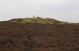
The summit is crowned by a trig point
, and a track passes about 100 metre to the south of this point. This track forms part of the route of both the Lyke Wake Walk
and the Cleveland Way
, and also forms the most commonly used route of ascent for Urra Moor. It is only 3 kilometres (1.9 mi) from the car park at Clay Bank to the summit via this route; total ascent is just under 200 metres (656.2 ft).
Urra Moor is noted for its prehistoric remains. There are a number of barrows
, and several carved rocks, including some cup and ring
carvings. Probably the most striking relic is the Face Stone, a carved stone about 1 metre in height into which has been carved the shape of a face
.
North York Moors
The North York Moors is a national park in North Yorkshire, England. The moors are one of the largest expanses of heather moorland in the United Kingdom. It covers an area of , and it has a population of about 25,000...
at 454 metres (1,454 ft) above sea level, in the national park
National parks of England and Wales
The national parks of England and Wales are areas of relatively undeveloped and scenic landscape that are designated under the National Parks and Access to the Countryside Act 1949...
in North Yorkshire
North Yorkshire
North Yorkshire is a non-metropolitan or shire county located in the Yorkshire and the Humber region of England, and a ceremonial county primarily in that region but partly in North East England. Created in 1974 by the Local Government Act 1972 it covers an area of , making it the largest...
, England
England
England is a country that is part of the United Kingdom. It shares land borders with Scotland to the north and Wales to the west; the Irish Sea is to the north west, the Celtic Sea to the south west, with the North Sea to the east and the English Channel to the south separating it from continental...
. The name applies to the moor
Moorland
Moorland or moor is a type of habitat, in the temperate grasslands, savannas, and shrublands biome, found in upland areas, characterised by low-growing vegetation on acidic soils and heavy fog...
as a whole; the summit itself is known as Round Hill.
The summit is crowned by a trig point
Trig point
A triangulation station, also known as a triangulation pillar, trigonometrical station, trigonometrical point, trig station, trig beacon or trig point, and sometimes informally as a trig, is a fixed surveying station, used in geodetic surveying and other surveying projects in its vicinity...
, and a track passes about 100 metre to the south of this point. This track forms part of the route of both the Lyke Wake Walk
Lyke Wake Walk
The Lyke Wake Walk was started by a local farmer, Bill Cowley, in the North Riding of Yorkshire, England, in 1955. He claimed that one could walk over the North York Moors from east to west on heather all the way except for crossing one or two roads and he issued a challenge that walkers took up...
and the Cleveland Way
Cleveland Way
The Cleveland Way is a National Trail in ancient Cleveland in Northern England. It runs 110 miles from Helmsley to Filey, skirting the North York Moors National Park.-History:The trail was opened in 1969...
, and also forms the most commonly used route of ascent for Urra Moor. It is only 3 kilometres (1.9 mi) from the car park at Clay Bank to the summit via this route; total ascent is just under 200 metres (656.2 ft).
Urra Moor is noted for its prehistoric remains. There are a number of barrows
Tumulus
A tumulus is a mound of earth and stones raised over a grave or graves. Tumuli are also known as barrows, burial mounds, Hügelgrab or kurgans, and can be found throughout much of the world. A tumulus composed largely or entirely of stones is usually referred to as a cairn...
, and several carved rocks, including some cup and ring
Cup and ring mark
Cup and ring marks or cup marks are a form of prehistoric art found mainly in Atlantic Europe and Mediterranean Europe although similar forms are also found throughout the world including Mexico, Brazil, Greece, and India, where...
carvings. Probably the most striking relic is the Face Stone, a carved stone about 1 metre in height into which has been carved the shape of a face
Face
The face is a central sense organ complex, for those animals that have one, normally on the ventral surface of the head, and can, depending on the definition in the human case, include the hair, forehead, eyebrow, eyelashes, eyes, nose, ears, cheeks, mouth, lips, philtrum, temple, teeth, skin, and...
.