
High Willhays
Encyclopedia
High Willhays or, according to some authors, High Willes is the highest point on Dartmoor
, Devon
, at 621 metres (2,039 ft) above sea level, and the highest point in Great Britain
south of the Brecon Beacons
.
, writer and documenter, said that the name High Willes had been thought to have derived from the word huel or wheal meaning mine, but he did not think that very likely as old mine workings were invariably located near to streams. He suggested instead that the name derived from gwylfa, a watching place, noting its similarity with Brown Willy
, the name of the highest hill on nearby Bodmin Moor
, and suggested that a watch for beacon fires used to be kept here. He also posited a possible link to the word gwili meaning winding or tortuous, but said it was unlikely this was where it originated from.
The Place-Names of Devon (1931) notes that the peak was named Hight Wyll in a document of 1532, and was known in 1827 as High Willows. The authors state that the name may simply be a compound of high and well (meaning spring), though they admit that the additional syllable at the end is hard to explain.
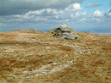
. Although it is the highest point of the moor, it is relatively insignificant in comparison to most of the moor's tors, consisting of no more than a few low outcrops of rock along a north-south ridge. The largest outcrop is crowned with a cairn. The more impressive, but slightly lower, Yes Tor
is about 1 km north along this ridge, which is known as "the roof of Devon".
High Willhays and Yes Tor are the only summits in England south of Kinder Scout
in the Peak District
to rise above 2000 feet (609.6 m), apart from Black Mountain which is on the Welsh
border. Before Ordnance Survey
measured accurately the heights of High Willhays and Yes Tor many people believed Yes Tor was the higher of the two, and it was only the local farmers and moormen that believed the contrary. However, the first topographical survey of the area carried out by Ordnance Survey suggested that High Willhays was twelve feet higher, although the difference has now been measured at just eight feet. William Crossing stated that High Willhays was the highest point in England south of Ingleborough
in the Yorkshire Dales, but since then surveys have shown that Kinder Scout is also higher.
The geology of High Willhays, like most of Dartmoor, consists of granite
intruded about 280 million years ago. However High Willhays is in an area of the northern plateau of the moor where the exposed rock has noticeably fewer of the large feldspar
megacrysts that are typical of most of Dartmoor's tors. Each of the outcrops displays lamellar bedding.
High Willhays is situated within one of Dartmoor's Danger Zones — areas used periodically by the British Army
for exercises. Red flags are raised around the perimeter when live-firing is due to take place.
Dartmoor
Dartmoor is an area of moorland in south Devon, England. Protected by National Park status, it covers .The granite upland dates from the Carboniferous period of geological history. The moorland is capped with many exposed granite hilltops known as tors, providing habitats for Dartmoor wildlife. The...
, Devon
Devon
Devon is a large county in southwestern England. The county is sometimes referred to as Devonshire, although the term is rarely used inside the county itself as the county has never been officially "shired", it often indicates a traditional or historical context.The county shares borders with...
, at 621 metres (2,039 ft) above sea level, and the highest point in Great Britain
Great Britain
Great Britain or Britain is an island situated to the northwest of Continental Europe. It is the ninth largest island in the world, and the largest European island, as well as the largest of the British Isles...
south of the Brecon Beacons
Brecon Beacons
The Brecon Beacons is a mountain range in South Wales. In a narrow sense, the name refers to the range of popular peaks south of Brecon, including South Wales' highest mountain, Pen y Fan, and which together form the central section of the Brecon Beacons National Park...
.
Toponymy
In 1912, William CrossingWilliam Crossing
William Crossing was a writer and documenter of Dartmoor and Dartmoor life. He lived successively at South Brent, Brentor and at Mary Tavy but died at Plymouth.-Early life:...
, writer and documenter, said that the name High Willes had been thought to have derived from the word huel or wheal meaning mine, but he did not think that very likely as old mine workings were invariably located near to streams. He suggested instead that the name derived from gwylfa, a watching place, noting its similarity with Brown Willy
Brown Willy
Brown Willy is a hill in Cornwall, United Kingdom. The summit is the highest point of Bodmin Moor and of Cornwall as a whole....
, the name of the highest hill on nearby Bodmin Moor
Bodmin Moor
Bodmin Moor is a granite moorland in northeastern Cornwall, England, United Kingdom. It is in size, and originally dates from the Carboniferous period of geological history....
, and suggested that a watch for beacon fires used to be kept here. He also posited a possible link to the word gwili meaning winding or tortuous, but said it was unlikely this was where it originated from.
The Place-Names of Devon (1931) notes that the peak was named Hight Wyll in a document of 1532, and was known in 1827 as High Willows. The authors state that the name may simply be a compound of high and well (meaning spring), though they admit that the additional syllable at the end is hard to explain.
Topography
High Willhays is near the north western edge of Dartmoor, about 2.5 km south east of Meldon Reservoir and about 5 km south of the town of OkehamptonOkehampton
Okehampton is a town and civil parish in West Devon in the English county of Devon. It is situated at the northern edge of Dartmoor, and has an estimated population of 7,155.-History:...
. Although it is the highest point of the moor, it is relatively insignificant in comparison to most of the moor's tors, consisting of no more than a few low outcrops of rock along a north-south ridge. The largest outcrop is crowned with a cairn. The more impressive, but slightly lower, Yes Tor
Yes Tor
Yes Tor is the second highest point on Dartmoor, Devon, South West England, at above sea level. Together with nearby High Willhays they are the only two peaks above south of the English Peak District National Park....
is about 1 km north along this ridge, which is known as "the roof of Devon".
High Willhays and Yes Tor are the only summits in England south of Kinder Scout
Kinder Scout
Kinder Scout is a moorland plateau in the Dark Peak of the Derbyshire Peak District in England. Part of the moor, at 636 m above sea level, is the highest point in the Peak District, the highest point in Derbyshire, and the highest point in the East Midlands. It is accessible from the villages of...
in the Peak District
Peak District
The Peak District is an upland area in central and northern England, lying mainly in northern Derbyshire, but also covering parts of Cheshire, Greater Manchester, Staffordshire, and South and West Yorkshire....
to rise above 2000 feet (609.6 m), apart from Black Mountain which is on the Welsh
Wales
Wales is a country that is part of the United Kingdom and the island of Great Britain, bordered by England to its east and the Atlantic Ocean and Irish Sea to its west. It has a population of three million, and a total area of 20,779 km²...
border. Before Ordnance Survey
Ordnance Survey
Ordnance Survey , an executive agency and non-ministerial government department of the Government of the United Kingdom, is the national mapping agency for Great Britain, producing maps of Great Britain , and one of the world's largest producers of maps.The name reflects its creation together with...
measured accurately the heights of High Willhays and Yes Tor many people believed Yes Tor was the higher of the two, and it was only the local farmers and moormen that believed the contrary. However, the first topographical survey of the area carried out by Ordnance Survey suggested that High Willhays was twelve feet higher, although the difference has now been measured at just eight feet. William Crossing stated that High Willhays was the highest point in England south of Ingleborough
Ingleborough
Ingleborough is the second highest mountain in the Yorkshire Dales. It is one of the Yorkshire Three Peaks, the other two being Whernside and Pen-y-ghent. Ingleborough is frequently climbed as part of the Yorkshire Three Peaks Challenge, which is a 24-mile circular challenge walk starting and...
in the Yorkshire Dales, but since then surveys have shown that Kinder Scout is also higher.
The geology of High Willhays, like most of Dartmoor, consists of granite
Granite
Granite is a common and widely occurring type of intrusive, felsic, igneous rock. Granite usually has a medium- to coarse-grained texture. Occasionally some individual crystals are larger than the groundmass, in which case the texture is known as porphyritic. A granitic rock with a porphyritic...
intruded about 280 million years ago. However High Willhays is in an area of the northern plateau of the moor where the exposed rock has noticeably fewer of the large feldspar
Feldspar
Feldspars are a group of rock-forming tectosilicate minerals which make up as much as 60% of the Earth's crust....
megacrysts that are typical of most of Dartmoor's tors. Each of the outcrops displays lamellar bedding.
High Willhays is situated within one of Dartmoor's Danger Zones — areas used periodically by the British Army
British Army
The British Army is the land warfare branch of Her Majesty's Armed Forces in the United Kingdom. It came into being with the unification of the Kingdom of England and Scotland into the Kingdom of Great Britain in 1707. The new British Army incorporated Regiments that had already existed in England...
for exercises. Red flags are raised around the perimeter when live-firing is due to take place.
External links
- Computer generated summit panorama High Willhays