

South Pennines
Encyclopedia
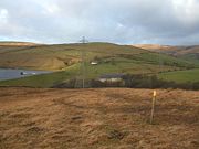
Moorland
Moorland or moor is a type of habitat, in the temperate grasslands, savannas, and shrublands biome, found in upland areas, characterised by low-growing vegetation on acidic soils and heavy fog...
and hill country in northern England
Northern England
Northern England, also known as the North of England, the North or the North Country, is a cultural region of England. It is not an official government region, but rather an informal amalgamation of counties. The southern extent of the region is roughly the River Trent, while the North is bordered...
lying towards the southern end of the Pennines
Pennines
The Pennines are a low-rising mountain range, separating the North West of England from Yorkshire and the North East.Often described as the "backbone of England", they form a more-or-less continuous range stretching from the Peak District in Derbyshire, around the northern and eastern edges of...
. It is bounded to the west by the Forest of Rossendale (sometimes referred to as the West Pennines) and the Yorkshire Dales
Yorkshire Dales
The Yorkshire Dales is the name given to an upland area in Northern England.The area lies within the historic county boundaries of Yorkshire, though it spans the ceremonial counties of North Yorkshire, West Yorkshire and Cumbria...
to the north. To the east it is fringed by the towns of West
West Yorkshire
West Yorkshire is a metropolitan county within the Yorkshire and the Humber region of England with a population of 2.2 million. West Yorkshire came into existence as a metropolitan county in 1974 after the passage of the Local Government Act 1972....
and South Yorkshire
South Yorkshire
South Yorkshire is a metropolitan county in the Yorkshire and the Humber region of England. It has a population of 1.29 million. It consists of four metropolitan boroughs: Barnsley, Doncaster, Rotherham, and City of Sheffield...
whilst to the south it is often considered to end at the northern edge of the Peak District
Peak District
The Peak District is an upland area in central and northern England, lying mainly in northern Derbyshire, but also covering parts of Cheshire, Greater Manchester, Staffordshire, and South and West Yorkshire....
national park
National park
A national park is a reserve of natural, semi-natural, or developed land that a sovereign state declares or owns. Although individual nations designate their own national parks differently A national park is a reserve of natural, semi-natural, or developed land that a sovereign state declares or...
. However some definitions of the region include the Peak District which extends to the eastern fringes of Greater Manchester
Greater Manchester
Greater Manchester is a metropolitan county in North West England, with a population of 2.6 million. It encompasses one of the largest metropolitan areas in the United Kingdom and comprises ten metropolitan boroughs: Bolton, Bury, Oldham, Rochdale, Stockport, Tameside, Trafford, Wigan, and the...
and Cheshire
Cheshire
Cheshire is a ceremonial county in North West England. Cheshire's county town is the city of Chester, although its largest town is Warrington. Other major towns include Widnes, Congleton, Crewe, Ellesmere Port, Runcorn, Macclesfield, Winsford, Northwich, and Wilmslow...
and into north Derbyshire
Derbyshire
Derbyshire is a county in the East Midlands of England. A substantial portion of the Peak District National Park lies within Derbyshire. The northern part of Derbyshire overlaps with the Pennines, a famous chain of hills and mountains. The county contains within its boundary of approx...
and a small part of north west Staffordshire
Staffordshire
Staffordshire is a landlocked county in the West Midlands region of England. For Eurostat purposes, the county is a NUTS 3 region and is one of four counties or unitary districts that comprise the "Shropshire and Staffordshire" NUTS 2 region. Part of the National Forest lies within its borders...
.
Within the South Pennines are a number of distinct upland areas including; Boulsworth Hill
Boulsworth Hill
Boulsworth Hill is a large expanse of moorland, the highest point of the South Pennines of south-eastern Lancashire, England, separating the District of Pendle from Calderdale....
, Hail Storm Hill
Hail Storm Hill
Hail Storm Hill, also known as Cowpe Moss, is the highest point of the Forest of Rossendale, an area of moorland and hill country situated between the West Pennine Moors and the South Pennines...
, Blackstone Edge
Blackstone Edge
Blackstone Edge is a gritstone escarpment at 1,549 feet above sea level in an area of moorland on the Greater Manchester–West Yorkshire county boundary, England....
and Hameldon. Kinder Scout
Kinder Scout
Kinder Scout is a moorland plateau in the Dark Peak of the Derbyshire Peak District in England. Part of the moor, at 636 m above sea level, is the highest point in the Peak District, the highest point in Derbyshire, and the highest point in the East Midlands. It is accessible from the villages of...
, Black Hill
Black Hill (Peak District)
Black Hill is a hill in the Peak District, England.It used to be the highest point in Cheshire, but now lies on the border between the boroughs of Kirklees in West Yorkshire and High Peak in Derbyshire, reaching above sea level....
and Bleaklow
Bleaklow
Bleaklow is a high, largely peat covered, gritstone moorland, just north of Kinder Scout, across the Snake Pass , in the Derbyshire High Peak near the town of Glossop...
all lie within the Peak District.
Settlement
A number of densely populated valleys are incised into these uplands, notably that of the River CalderRiver Calder, West Yorkshire
The River Calder is a river in West Yorkshire, in Northern England.The Calder rises on the green eastern slopes of the Pennines flows through alternating green countryside, former woollen-mill villages, and large and small towns before joining the River Aire near Castleford.The river's valley is...
which provides a low-level route for road, railway and canal
Leeds and Liverpool Canal
The Leeds and Liverpool Canal is a canal in Northern England, linking the cities of Leeds and Liverpool. Over a distance of , it crosses the Pennines, and includes 91 locks on the main line...
between Lancashire
Lancashire
Lancashire is a non-metropolitan county of historic origin in the North West of England. It takes its name from the city of Lancaster, and is sometimes known as the County of Lancaster. Although Lancaster is still considered to be the county town, Lancashire County Council is based in Preston...
and West Yorkshire
West Yorkshire
West Yorkshire is a metropolitan county within the Yorkshire and the Humber region of England with a population of 2.2 million. West Yorkshire came into existence as a metropolitan county in 1974 after the passage of the Local Government Act 1972....
. The towns of Hebden Bridge
Hebden Bridge
Hebden Bridge is a market town within the Metropolitan Borough of Calderdale, in West Yorkshire, England. It forms part of the Upper Calder Valley and lies 8 miles west of Halifax and 14 miles north east of Rochdale, at the confluence of the River Calder and the River Hebden .A 2004 profile of...
and Todmorden
Todmorden
Todmorden is a market town and civil parish, located 17 miles from Manchester, within the Metropolitan Borough of Calderdale, in West Yorkshire, England. It forms part of the Upper Calder Valley and has a total population of 14,941....
are situated within their confines. The region is surrounded by former mill towns such as Burnley
Burnley
Burnley is a market town in the Burnley borough of Lancashire, England, with a population of around 73,500. It lies north of Manchester and east of Preston, at the confluence of the River Calder and River Brun....
, Nelson
Nelson, Lancashire
Nelson is a town and civil parish in the Borough of Pendle in Lancashire, England, with a population of 28,998 in 2001. It lies 4 miles north of Burnley on the Leeds and Liverpool Canal....
, Colne
Colne
Colne is the second largest town and civil parish in the Borough of Pendle in Lancashire, England, with a population of 20,118. It lies at the eastern end of the M65, 6 miles north-east of Burnley, with Nelson immediately adjacent, in the Aire Gap with two main roads leading into the Yorkshire...
, Littleborough and Halifax
Halifax, West Yorkshire
Halifax is a minster town, within the Metropolitan Borough of Calderdale in West Yorkshire, England. It has an urban area population of 82,056 in the 2001 Census. It is well-known as a centre of England's woollen manufacture from the 15th century onward, originally dealing through the Halifax Piece...
.
Tourism
Walking, mountain-biking and horseriding are common pastimes enjoyed in the area. Numerous walking trails have been established including, amongst many others, the Calderdale WayCalderdale Way
The Calderdale Way is a long-distance footpath of about fifty miles in West Yorkshire. It was devised in the 1970s to draw attention to some of the attractions in the district of Calderdale, which was being established at that time....
and the Bronte Way
Brontë Way
The Brontë Way is a waymarked long-distance footpath in the northern counties of West Yorkshire and Lancashire, England, United Kingdom.-Length:The Brontë Way runs for 69 km...
. The long-established Pennine Way
Pennine Way
The Pennine Way is a National Trail in England. The trail runs from Edale, in the northern Derbyshire Peak District, north through the Yorkshire Dales and the Northumberland National Park and ends at Kirk Yetholm, just inside the Scottish border. The path runs along the Pennine hills, sometimes...
also runs through the area of course.
The South Pennines Walk & Ride Festival takes place annually in September and is a two-week long celebration of the area's landscape
Landscape
Landscape comprises the visible features of an area of land, including the physical elements of landforms such as mountains, hills, water bodies such as rivers, lakes, ponds and the sea, living elements of land cover including indigenous vegetation, human elements including different forms of...
. Typical events include guided walk
WALK
WALK may refer to:*WALK , a radio station licensed to East Patchogue, New York, United States*WALK-FM, a radio station licensed to Patchogue, New York, United States...
s, mountain bike
Mountain bike
A mountain bike or mountain bicycle is a bicycle created for off-road cycling. This activity includes traversing of rocks and washouts, and steep declines,...
rides, horse
Horse
The horse is one of two extant subspecies of Equus ferus, or the wild horse. It is a single-hooved mammal belonging to the taxonomic family Equidae. The horse has evolved over the past 45 to 55 million years from a small multi-toed creature into the large, single-toed animal of today...
rides, orienteering
Orienteering
Orienteering is a family of sports that requires navigational skills using a map and compass to navigate from point to point in diverse and usually unfamiliar terrain, and normally moving at speed. Participants are given a topographical map, usually a specially prepared orienteering map, which they...
events, evening talks by noted outdoors people and more. The event is overseen by Pennine Prospects (see external link, below) and has been organised on its behalf since 2008 by outdoor journalist and consultant John Manning (see external link, below).
External links
- Pennine Prospects South Pennines Regeneration Company
- Outdoor Festival South Pennines Walk & Ride Festival 2011