

Edale
Encyclopedia
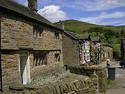
Edale is a small Derbyshire
village
and Civil parish
in the Peak District
, in the Midlands of England
. The Parish of Edale,
area 2844.8 hectares (7,029.6 acre),
is in the Borough of High Peak.
Edale is best known to walkers as the start (or southern end) of the Pennine Way
, and to less ambitious walkers as a good starting point for evening or day walks, accessible by public transport from Sheffield
or Manchester
and with two pub
s supplying real ale and food.
 As spelt, the name is first recorded in 1732. Earlier recorded versions of the name are Aidele (1086), Heydale (1251), Eydale (1275), Eydal (1285) and Edall (1550).
Historically, Edale was the name of the valley of the River Noe
. From the Norman Conquest it was within the royal Forest of High Peak
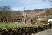
and at its centre is the Edale Cross, which marked the boundary of the three wards at the Forest, Campana, Hopedale and Longdendale. Settlement in the valley consists of several booths, originally established in the 13th century as 'vaccaries' (cattle farms) along the valley of the River Noe, which have since developed into the hamlets of Upper Booth (once Crowdenley Booth and Over Booth), Barber Booth (once Whitmorely Booth), Grindsbrook Booth, Ollerbrook Booth and Nether Booth (also known as Lady Booth and, formerly, Lower Booth).
 When the Sheffield to Manchester (Hope Valley
) line opened, the railway station
to the south of Grindsbrook Booth was named "Edale", and the name came to be used for the settlements in the parish, rather than the valley as a whole. The valley is usually now referred to as the "Vale of Edale" or, much less frequently, as the "Noe Valley".
mill built in 1795 on the site of a corn mill and tannery by Nicholas Cresswell in partnership with James Harrison, Robert Blackwell and Joseph Fletcher. Workers were brought in from the towns and accommodated in cottages and in a nearby house called Skinners Hall. Many of the women workers walked each day from Castleton over the thousand-foot Hollins Cross pass. The mill continued spinning cotton until around 1940 but then fell into disuse. It was restored in the early 1970s by the Landmark Trust
who sold off six of the apartments to fund the restoration. The Landmark Trust retain one apartment as holiday accommodation.
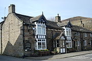
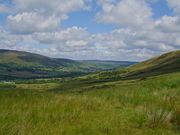 As well as being the start of the Pennine Way (the official start is the Old Nag's Head, a former smithy dating back to 1577), the village is surrounded by walking country which is excellent in its own right. The village is surrounded by hills: the plateau of Kinder Scout
to the north, where the highest point in the parish is found, the Great Ridge (running west to east between Rushup Edge
over Mam Tor
to Lose Hill
) to the south and east, Win Hill
to the east (outside the parish), and Dalehead (Brown Knoll, Horsehill Tor and Colborne) to the west. Almost the entire parish is over 200m above sea level; only along the River Noe east from Carr House does the elevation drop below this level.
The bed and banks of the River Noe from Barber Booth upstream to approximately the 320 metres (1,049.9 ft) contour constitute the Edale SSSI
, cited for geological interest. The "important exposures" of the Edale Shale
s here contain fossils of technical interest.
s, and both pubs also provide accommodation. The pubs also provide food, and there are two cafés. In 2006 a new information and visitor centre was opened at Fieldhead. It was developed by the Moors for the Future Partnership and is owned and operated by the Peak District National Park Authority. Edale is also a popular camping village with two major campsites and numerous others in the surrounding area.
The train service is reasonably frequent for such a rural area, and there is a limited bus service. The short but narrow, twisting and dead-end road to the village centre is not suitable for visitors' cars, and parking in the village centre is almost impossible. However, there is a large pay-and-display car park near the village hall, and parking for rail users at the railway station. Additional parking near the station is provided at busy times by the Parish Council.
Derbyshire
Derbyshire is a county in the East Midlands of England. A substantial portion of the Peak District National Park lies within Derbyshire. The northern part of Derbyshire overlaps with the Pennines, a famous chain of hills and mountains. The county contains within its boundary of approx...
village
Village
A village is a clustered human settlement or community, larger than a hamlet with the population ranging from a few hundred to a few thousand , Though often located in rural areas, the term urban village is also applied to certain urban neighbourhoods, such as the West Village in Manhattan, New...
and Civil parish
Civil parish
In England, a civil parish is a territorial designation and, where they are found, the lowest tier of local government below districts and counties...
in the Peak District
Peak District
The Peak District is an upland area in central and northern England, lying mainly in northern Derbyshire, but also covering parts of Cheshire, Greater Manchester, Staffordshire, and South and West Yorkshire....
, in the Midlands of England
England
England is a country that is part of the United Kingdom. It shares land borders with Scotland to the north and Wales to the west; the Irish Sea is to the north west, the Celtic Sea to the south west, with the North Sea to the east and the English Channel to the south separating it from continental...
. The Parish of Edale,
area 2844.8 hectares (7,029.6 acre),
is in the Borough of High Peak.
Edale is best known to walkers as the start (or southern end) of the Pennine Way
Pennine Way
The Pennine Way is a National Trail in England. The trail runs from Edale, in the northern Derbyshire Peak District, north through the Yorkshire Dales and the Northumberland National Park and ends at Kirk Yetholm, just inside the Scottish border. The path runs along the Pennine hills, sometimes...
, and to less ambitious walkers as a good starting point for evening or day walks, accessible by public transport from Sheffield
Sheffield
Sheffield is a city and metropolitan borough of South Yorkshire, England. Its name derives from the River Sheaf, which runs through the city. Historically a part of the West Riding of Yorkshire, and with some of its southern suburbs annexed from Derbyshire, the city has grown from its largely...
or Manchester
Manchester
Manchester is a city and metropolitan borough in Greater Manchester, England. According to the Office for National Statistics, the 2010 mid-year population estimate for Manchester was 498,800. Manchester lies within one of the UK's largest metropolitan areas, the metropolitan county of Greater...
and with two pub
Public house
A public house, informally known as a pub, is a drinking establishment fundamental to the culture of Britain, Ireland, Australia and New Zealand. There are approximately 53,500 public houses in the United Kingdom. This number has been declining every year, so that nearly half of the smaller...
s supplying real ale and food.
History
Historically, Edale was the name of the valley of the River Noe
River Noe
The River Noe is a tributary of the River Derwent in Derbyshire, England. It flows approximately 7.5 miles from its source, the confluence of two streams running off Kinder Scout in the Peak District, east through Edale and then southeast through the village of Hope.The river flows into the River...
. From the Norman Conquest it was within the royal Forest of High Peak
Forest of High Peak
The Forest of High Peak was, in medieval times, a moorland forest covering most of the North West of Derbyshire, in England as far south as Tideswell and Buxton....
and at its centre is the Edale Cross, which marked the boundary of the three wards at the Forest, Campana, Hopedale and Longdendale. Settlement in the valley consists of several booths, originally established in the 13th century as 'vaccaries' (cattle farms) along the valley of the River Noe, which have since developed into the hamlets of Upper Booth (once Crowdenley Booth and Over Booth), Barber Booth (once Whitmorely Booth), Grindsbrook Booth, Ollerbrook Booth and Nether Booth (also known as Lady Booth and, formerly, Lower Booth).
Hope Valley Line
The Hope Valley Line is a railway line in England linking Sheffield with Manchester. It was completed in 1894.From Sheffield, trains head down the Midland Main Line to Dore, where the Hope Valley Line branches off to run through the Totley Tunnel .It emerges in the stunning scenery of the Hope...
) line opened, the railway station
Edale railway station
Edale railway station serves the Vale of Edale in the Derbyshire Peak District, in England. It was opened in 1894 on the Midland Railway's Dore and Chinley line , becoming an unstaffed halt in 1969....
to the south of Grindsbrook Booth was named "Edale", and the name came to be used for the settlements in the parish, rather than the valley as a whole. The valley is usually now referred to as the "Vale of Edale" or, much less frequently, as the "Noe Valley".
Cotton mill
Edale is the site of an historic cottonCotton
Cotton is a soft, fluffy staple fiber that grows in a boll, or protective capsule, around the seeds of cotton plants of the genus Gossypium. The fiber is almost pure cellulose. The botanical purpose of cotton fiber is to aid in seed dispersal....
mill built in 1795 on the site of a corn mill and tannery by Nicholas Cresswell in partnership with James Harrison, Robert Blackwell and Joseph Fletcher. Workers were brought in from the towns and accommodated in cottages and in a nearby house called Skinners Hall. Many of the women workers walked each day from Castleton over the thousand-foot Hollins Cross pass. The mill continued spinning cotton until around 1940 but then fell into disuse. It was restored in the early 1970s by the Landmark Trust
Landmark Trust
The Landmark Trust is a British building conservation charity, founded in 1965 by Sir John and Lady Smith, that rescues buildings of historic interest or architectural merit and then gives them a new life by making them available for holiday rental...
who sold off six of the apartments to fund the restoration. The Landmark Trust retain one apartment as holiday accommodation.
Countryside
Kinder Scout
Kinder Scout is a moorland plateau in the Dark Peak of the Derbyshire Peak District in England. Part of the moor, at 636 m above sea level, is the highest point in the Peak District, the highest point in Derbyshire, and the highest point in the East Midlands. It is accessible from the villages of...
to the north, where the highest point in the parish is found, the Great Ridge (running west to east between Rushup Edge
Rushup Edge
Rushup Edge is a ridge in the Derbyshire Peak District of England. The ridge's highest point is Lord's Seat at , while Mam Tor lies at its eastern end, beyond which the Great Ridge runs.-References:...
over Mam Tor
Mam Tor
Mam Tor is a hill near Castleton in the High Peak of Derbyshire, England. Its name literally translates as Heights of the Mother and it is also known as the Shivering Mountain on account of the instability of its lower shale layers...
to Lose Hill
Lose Hill
Lose Hill lies in the Derbyshire Peak District. It is the south-west corner of the parish of Edale and the end of the Great Ridge that runs from Rushup Edge to the west .Local access activist G. H. B...
) to the south and east, Win Hill
Win Hill
Win Hill lies north west of Bamford in the Derbyshire Peak District of England. At , it is almost surrounded by the River Derwent to the east, River Noe to the south west and Ladybower Reservoir to the north, but a ridge running north west links it to Kinder Scout...
to the east (outside the parish), and Dalehead (Brown Knoll, Horsehill Tor and Colborne) to the west. Almost the entire parish is over 200m above sea level; only along the River Noe east from Carr House does the elevation drop below this level.
The bed and banks of the River Noe from Barber Booth upstream to approximately the 320 metres (1,049.9 ft) contour constitute the Edale SSSI
Site of Special Scientific Interest
A Site of Special Scientific Interest is a conservation designation denoting a protected area in the United Kingdom. SSSIs are the basic building block of site-based nature conservation legislation and most other legal nature/geological conservation designations in Great Britain are based upon...
, cited for geological interest. The "important exposures" of the Edale Shale
Shale
Shale is a fine-grained, clastic sedimentary rock composed of mud that is a mix of flakes of clay minerals and tiny fragments of other minerals, especially quartz and calcite. The ratio of clay to other minerals is variable. Shale is characterized by breaks along thin laminae or parallel layering...
s here contain fossils of technical interest.
Amenities
There is a youth hostel about a mile from the village centre, several B&BBed and breakfast
A bed and breakfast is a small lodging establishment that offers overnight accommodation and breakfast, but usually does not offer other meals. Since the 1980s, the meaning of the term has also extended to include accommodations that are also known as "self-catering" establishments...
s, and both pubs also provide accommodation. The pubs also provide food, and there are two cafés. In 2006 a new information and visitor centre was opened at Fieldhead. It was developed by the Moors for the Future Partnership and is owned and operated by the Peak District National Park Authority. Edale is also a popular camping village with two major campsites and numerous others in the surrounding area.
The train service is reasonably frequent for such a rural area, and there is a limited bus service. The short but narrow, twisting and dead-end road to the village centre is not suitable for visitors' cars, and parking in the village centre is almost impossible. However, there is a large pay-and-display car park near the village hall, and parking for rail users at the railway station. Additional parking near the station is provided at busy times by the Parish Council.