

Purbeck Hills
Encyclopedia

Chalk
Chalk is a soft, white, porous sedimentary rock, a form of limestone composed of the mineral calcite. Calcite is calcium carbonate or CaCO3. It forms under reasonably deep marine conditions from the gradual accumulation of minute calcite plates shed from micro-organisms called coccolithophores....
downs
Downland
A downland is an area of open chalk hills. This term is especially used to describe the chalk countryside in southern England. Areas of downland are often referred to as Downs....
in Dorset
Dorset
Dorset , is a county in South West England on the English Channel coast. The county town is Dorchester which is situated in the south. The Hampshire towns of Bournemouth and Christchurch joined the county with the reorganisation of local government in 1974...
, England
England
England is a country that is part of the United Kingdom. It shares land borders with Scotland to the north and Wales to the west; the Irish Sea is to the north west, the Celtic Sea to the south west, with the North Sea to the east and the English Channel to the south separating it from continental...
. The hills extend from the Dorset Downs
Dorset Downs
The Dorset Downs are an area of Chalk downland in the centre of the county Dorset in south west England. The downs are the most western part of a larger Chalk Formation which also includes Cranborne Chase, Salisbury Plain, Hampshire Downs, Chiltern Hills, North Downs and South Downs.The Dorset...
west of Dorchester, where the River Frome
River Frome, Dorset
The River Frome is a river in Dorset in the south of England. At 30 miles long it is the major chalkstream in southwest England. It is navigable upstream from Poole Harbour as far as the town of Wareham.-Geography:...
begins to form a valley dividing them from the larger area of downland to the north. The ridge then runs east through the Isle of Purbeck
Isle of Purbeck
The Isle of Purbeck, not a true island but a peninsula, is in the county of Dorset, England. It is bordered by the English Channel to the south and east, where steep cliffs fall to the sea; and by the marshy lands of the River Frome and Poole Harbour to the north. Its western boundary is less well...
to Old Harry Rocks
Old Harry Rocks
The Old Harry Rocks are two chalk sea stacks located at Handfast Point, on the Isle of Purbeck in Dorset, southern England.- Location :Old Harry Rocks lie directly east of Studland, about 4 kilometres northeast of Swanage, and about 10 kilometres south of the large towns of Poole and...
where it meets the sea. The hills are part of the southern England
England
England is a country that is part of the United Kingdom. It shares land borders with Scotland to the north and Wales to the west; the Irish Sea is to the north west, the Celtic Sea to the south west, with the North Sea to the east and the English Channel to the south separating it from continental...
Chalk Formation
Chalk Formation
The Chalk Group is a lithostratigraphic unit in the northwestern part of Europe. It is characterised by thick deposits of chalk, a soft porous white limestone, deposited in a marine environment during the Upper Cretaceous period.Chalk is a limestone that consists of coccolith biomicrite...
which also includes Salisbury Plain
Salisbury Plain
Salisbury Plain is a chalk plateau in central southern England covering . It is part of the Southern England Chalk Formation and largely lies within the county of Wiltshire, with a little in Hampshire. The plain is famous for its rich archaeology, including Stonehenge, one of England's best known...
and the South Downs
South Downs
The South Downs is a range of chalk hills that extends for about across the south-eastern coastal counties of England from the Itchen Valley of Hampshire in the west to Beachy Head, near Eastbourne, East Sussex, in the east. It is bounded on its northern side by a steep escarpment, from whose...
, and would once have been continuous with the Isle of Wight
Isle of Wight
The Isle of Wight is a county and the largest island of England, located in the English Channel, on average about 2–4 miles off the south coast of the county of Hampshire, separated from the mainland by a strait called the Solent...
to the east. For most of their length the chalk is protected from coast
Coast
A coastline or seashore is the area where land meets the sea or ocean. A precise line that can be called a coastline cannot be determined due to the dynamic nature of tides. The term "coastal zone" can be used instead, which is a spatial zone where interaction of the sea and land processes occurs...
al erosion
Erosion
Erosion is when materials are removed from the surface and changed into something else. It only works by hydraulic actions and transport of solids in the natural environment, and leads to the deposition of these materials elsewhere...
by the a band of resistant Portland limestone, where this band ends, at Durlston Head, the clay
Clay
Clay is a general term including many combinations of one or more clay minerals with traces of metal oxides and organic matter. Geologic clay deposits are mostly composed of phyllosilicate minerals containing variable amounts of water trapped in the mineral structure.- Formation :Clay minerals...
and chalk behind has been eroded, creating Poole
Poole
Poole is a large coastal town and seaport in the county of Dorset, on the south coast of England. The town is east of Dorchester, and Bournemouth adjoins Poole to the east. The Borough of Poole was made a unitary authority in 1997, gaining administrative independence from Dorset County Council...
bay and the Solent
Solent
The Solent is a strait separating the Isle of Wight from the mainland of England.The Solent is a major shipping route for passengers, freight and military vessels. It is an important recreational area for water sports, particularly yachting, hosting the Cowes Week sailing event annually...
.
The height of the chalk ridge and proximity to Poole Harbour
Poole Harbour
Poole Harbour is a large natural harbour in Dorset, southern England, with the town of Poole on its shores. The harbour is a drowned valley formed at the end of the last ice age and is the estuary of several rivers, the largest being the Frome. The harbour has a long history of human settlement...
and the south coast have made the hills of strategic importance. There are a number of Iron Age
Iron Age
The Iron Age is the archaeological period generally occurring after the Bronze Age, marked by the prevalent use of iron. The early period of the age is characterized by the widespread use of iron or steel. The adoption of such material coincided with other changes in society, including differing...
, Roman
Roman Britain
Roman Britain was the part of the island of Great Britain controlled by the Roman Empire from AD 43 until ca. AD 410.The Romans referred to the imperial province as Britannia, which eventually comprised all of the island of Great Britain south of the fluid frontier with Caledonia...
and Saxon
Anglo-Saxons
Anglo-Saxon is a term used by historians to designate the Germanic tribes who invaded and settled the south and east of Great Britain beginning in the early 5th century AD, and the period from their creation of the English nation to the Norman conquest. The Anglo-Saxon Era denotes the period of...
archaeological sites, such as Nine Barrow Down
Nine Barrow Down
Nine Barrow Down is an elongated hill forming the northern ridge of the Purbeck Hills on the Isle of Purbeck in Dorset, England. The chalk down is part of the extensive Southern England Chalk Formation. The eastern end of the ridge, which carries the highest point, is also sometimes known as...
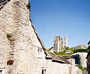
. At Corfe Castle
Corfe Castle
Corfe Castle is a village and civil parish in the English county of Dorset. It is the site of a ruined castle of the same name. The village and castle stand over a gap in the Purbeck Hills on the route between Wareham and Swanage. The village lies in the gap below the castle, and is some eight...
the hills are broken twice leaving a steep round hill between the ridges on which stood a medieval castle, guarding the only easy route through the hills, until the English Civil War
English Civil War
The English Civil War was a series of armed conflicts and political machinations between Parliamentarians and Royalists...
of the 17th century, when it was ruined.
Some of the ridge, around the village of Tyneham
Tyneham
Tyneham is a ghost village in south Dorset, England, near Lulworth on the Isle of Purbeck. It remains a civil parish.-Location:The village is situated northeast of Worbarrow Bay on the Jurassic Coast, about south of Wareham and about west of Swanage. It is part of the Lulworth Estate. Tyneham is...
, near Lulworth
Lulworth
Lulworth is the popular name for an area on the coast of Dorset, South West England notable for its castle and cove. However there is no actual place or feature called simply "Lulworth", the villages are East and West Lulworth and the coastal feature is Lulworth Cove.See:*East Lulworth *Lulworth...
, has been closed to the public for use by the army
British Army
The British Army is the land warfare branch of Her Majesty's Armed Forces in the United Kingdom. It came into being with the unification of the Kingdom of England and Scotland into the Kingdom of Great Britain in 1707. The new British Army incorporated Regiments that had already existed in England...
as a firing range. This has protected them from damage from farming and development, and these areas are now natural reserves. At the eastern end Ballard Down
Ballard Down
Ballard Down is an area of chalk downland in Dorset, southern England.The down forms a headland, Ballard Point, between Studland and Swanage bays in the English Channel, and once formed part of a continuous chalk ridge between what are now west Dorset and the Isle of Wight, part of the Southern...
is a National Trust
National Trust for Places of Historic Interest or Natural Beauty
The National Trust for Places of Historic Interest or Natural Beauty, usually known as the National Trust, is a conservation organisation in England, Wales and Northern Ireland...
nature reserve
Nature reserve
A nature reserve is a protected area of importance for wildlife, flora, fauna or features of geological or other special interest, which is reserved and managed for conservation and to provide special opportunities for study or research...
which is managed for its calcareous grassland
Calcareous grassland
Calcareous grassland is an ecosystem associated with thin basic soil, such as that on chalk and limestone downland. Plants on calcareous grassland are typically short and hardy, and include grasses and herbs such as clover...
habitat
Habitat (ecology)
A habitat is an ecological or environmental area that is inhabited by a particular species of animal, plant or other type of organism...
.
See also
- Isle of PurbeckIsle of PurbeckThe Isle of Purbeck, not a true island but a peninsula, is in the county of Dorset, England. It is bordered by the English Channel to the south and east, where steep cliffs fall to the sea; and by the marshy lands of the River Frome and Poole Harbour to the north. Its western boundary is less well...
- Geology of DorsetGeology of DorsetDorset, England, rests on a variety of different rock types which give the county its interesting landscapes and habitats. Dorset is particularly noted for its coastline, the Jurassic Coast, which in 2001 was designated a World Heritage Site because of the variety of landforms and fossils...
- Jurassic CoastJurassic CoastThe Jurassic Coast is a World Heritage Site on the English Channel coast of southern England. The site stretches from Orcombe Point near Exmouth in East Devon to Old Harry Rocks near Swanage in East Dorset, a distance of ....