
Walbury Hill
Encyclopedia
Walbury Hill is the highest point in the traditional county of Berkshire
in the UK at 297 metres (974 ft) above sea level. It is also the highest point in the South East of England, West Berkshire
being a constituent part of the South East of England. It is just 3 metres (10 ft) higher than Leith Hill
in Surrey
which is the second highest point in the South East.
It is situated on the border between the civil parish
es of Inkpen
and Combe
in southwestern Berkshire
(the latter formerly in Hampshire
). It is close to the Hampshire border and 7 kilometres (4.3 mi) southeast of Hungerford
, the closest town. On its summit is the Iron Age
hill fort
of Walbury Camp. Combe Gibbet
stands on the adjoining Gallows Down.
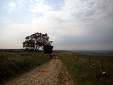
The true summit is marked by a triangulation pillar approximately 100 metres (328.1 ft) from the main Test Way. Walbury Hill is sometimes used by the BBC
as a temporary relay station during major sporting events. There is no metalled road across the hill, but the byway is open to all traffic and maintained with a hard gravel surface, probably because of its use by outside broadcast vehicles. The ridged summit is also popular with paragliding enthusiasts.
It is the start point for both the Test Way
and the Wayfarers Walk
.
There is also a small low level circular brick building, approximately 6 feet (1.8 metres) high, on the south side of the hill. This appears to be a disused reservoir.
Berkshire
Berkshire is a historic county in the South of England. It is also often referred to as the Royal County of Berkshire because of the presence of the royal residence of Windsor Castle in the county; this usage, which dates to the 19th century at least, was recognised by the Queen in 1957, and...
in the UK at 297 metres (974 ft) above sea level. It is also the highest point in the South East of England, West Berkshire
West Berkshire
West Berkshire is a local government district in the ceremonial county of Berkshire, England, governed by a unitary authority . Its administrative capital is Newbury, located almost equidistantly between Bristol and London.-Geography:...
being a constituent part of the South East of England. It is just 3 metres (10 ft) higher than Leith Hill
Leith Hill
Leith Hill to the south west of Dorking, Surrey, England, reaches above sea level, the highest point on the Greensand Ridge, and is the second highest point in south-east England, after Walbury Hill near Hungerford, West Berkshire, high....
in Surrey
Surrey
Surrey is a county in the South East of England and is one of the Home Counties. The county borders Greater London, Kent, East Sussex, West Sussex, Hampshire and Berkshire. The historic county town is Guildford. Surrey County Council sits at Kingston upon Thames, although this has been part of...
which is the second highest point in the South East.
It is situated on the border between the civil parish
Civil parish
In England, a civil parish is a territorial designation and, where they are found, the lowest tier of local government below districts and counties...
es of Inkpen
Inkpen
Inkpen is a village and civil parish in West Berkshire about southeast of Hungerford, close to the county boundaries with Wiltshire and Hampshire.-Amenities and landmarks:...
and Combe
Combe, Berkshire
Combe is a village and civil parish in the English county of Berkshire. It is situated in the district of West Berkshire,on the top of the downs near Walbury Hill and Combe Gibbet, overlooking the village of Inkpen and the valley of the River Kennet...
in southwestern Berkshire
Berkshire
Berkshire is a historic county in the South of England. It is also often referred to as the Royal County of Berkshire because of the presence of the royal residence of Windsor Castle in the county; this usage, which dates to the 19th century at least, was recognised by the Queen in 1957, and...
(the latter formerly in Hampshire
Hampshire
Hampshire is a county on the southern coast of England in the United Kingdom. The county town of Hampshire is Winchester, a historic cathedral city that was once the capital of England. Hampshire is notable for housing the original birthplaces of the Royal Navy, British Army, and Royal Air Force...
). It is close to the Hampshire border and 7 kilometres (4.3 mi) southeast of Hungerford
Hungerford
Hungerford is a market town and civil parish in Berkshire, England, 9 miles west of Newbury. It covers an area of and, according to the 2001 census, has a population of 5,559 .- Geography :...
, the closest town. On its summit is the Iron Age
Iron Age
The Iron Age is the archaeological period generally occurring after the Bronze Age, marked by the prevalent use of iron. The early period of the age is characterized by the widespread use of iron or steel. The adoption of such material coincided with other changes in society, including differing...
hill fort
Hill fort
A hill fort is a type of earthworks used as a fortified refuge or defended settlement, located to exploit a rise in elevation for defensive advantage. They are typically European and of the Bronze and Iron Ages. Some were used in the post-Roman period...
of Walbury Camp. Combe Gibbet
Combe Gibbet
Combe Gibbet is a gibbet at the top of Gallows Down, near the village and just within the civil parish of Combe in Berkshire .-Location:...
stands on the adjoining Gallows Down.
The true summit is marked by a triangulation pillar approximately 100 metres (328.1 ft) from the main Test Way. Walbury Hill is sometimes used by the BBC
BBC
The British Broadcasting Corporation is a British public service broadcaster. Its headquarters is at Broadcasting House in the City of Westminster, London. It is the largest broadcaster in the world, with about 23,000 staff...
as a temporary relay station during major sporting events. There is no metalled road across the hill, but the byway is open to all traffic and maintained with a hard gravel surface, probably because of its use by outside broadcast vehicles. The ridged summit is also popular with paragliding enthusiasts.
It is the start point for both the Test Way
Test Way
The Test Way is a long-distance footpath in England from Walbury Hill in West Berkshire to Eling in Hampshire.The northern end of the footpath starts in the car park on Walbury Hill...
and the Wayfarers Walk
Wayfarers Walk
The Wayfarer's Walk is a long distance footpath in England from Walbury Hill, Berkshire to Emsworth, Hampshire.The footpath can be walked in either direction...
.
There is also a small low level circular brick building, approximately 6 feet (1.8 metres) high, on the south side of the hill. This appears to be a disused reservoir.